Foster Wood

Wood, Forest in Yorkshire

England

Foster Wood

Willow pony A willow sculpture of what appears to be a Dales pony at Hardcastle Crags.
Willow pony Credit: Kathleen Illingworth

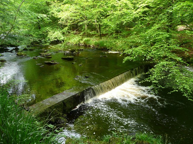
Foster Wood, located in Yorkshire, England, is a picturesque and serene forest area that covers a vast expanse of approximately 500 acres. The wood is situated in the heart of the county, surrounded by rolling hills and meandering streams, offering visitors a true escape into nature.

The woodland is predominantly made up of ancient oak and beech trees, some of which are believed to be over 300 years old. The dense canopy formed by these majestic trees provides shelter for a diverse range of flora and fauna, making it a haven for wildlife enthusiasts and nature lovers alike.

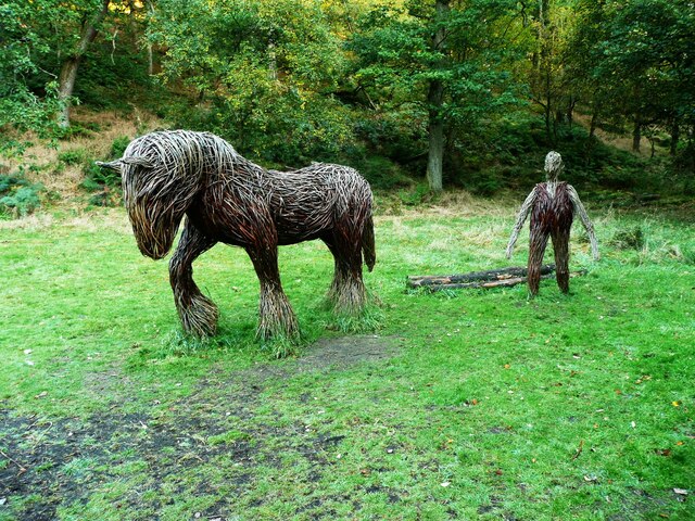
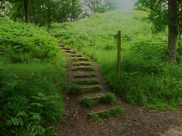
Walking trails wind their way through the wood, offering visitors the opportunity to explore its beauty at their own pace. As they meander through the forest, visitors will encounter a variety of wildlife, including deer, squirrels, and a wide array of bird species. The wood is also home to a number of rare and endangered species, such as the red kite and the white-clawed crayfish.

Foster Wood is not only a place of natural beauty but also holds historical significance. It is believed to have been a hunting ground for the ancient Vikings, and remnants of their presence can still be found in the form of archaeological sites and ancient burial mounds.

The wood is managed by a local conservation group, which ensures the preservation of its natural habitats and the promotion of sustainable practices. They organize guided walks, educational programs, and workshops to raise awareness about the importance of protecting this precious woodland ecosystem.

Overall, Foster Wood is a captivating destination that offers a unique blend of natural splendor, historical value, and environmental conservation. It is a must-visit for those seeking solace in the beauty of Yorkshire's countryside.

If you have any feedback on the listing, please let us know in the comments section below.

Foster Wood Images

Images are sourced within 2km of 53.750017/-2.0449103 or Grid Reference SD9728. Thanks to Geograph Open Source API. All images are credited.

Willow pony A willow sculpture of what appears to be a Dales pony at Hardcastle Crags.
Willow pony
A willow sculpture of what appears to be a Dales pony at Hardcastle Crags.
Weir on Hebden Water, Hardcastle Crags
Rock outcrop, Hardcastle Crags
Willow sculptures, Hardcastle Crags A carthorse and a farmer.
Willow sculptures, Hardcastle Crags
A carthorse and a farmer.
Path to the crags, Hardcastle crags
Weir on Hebden Water I don't know what was the purpose of this weir - perhaps water was piped down to one of the Gibson Mill ponds.
Weir on Hebden Water
I don't know what was the purpose of this weir - perhaps water was piped down to one of the Gibson Mill ponds.
Woodland near Hardcastle Crags The sign explains how the National Trust have a programme to remove non-native species of tree, to allow the native ones to grow back.
Woodland near Hardcastle Crags
The sign explains how the National Trust have a programme to remove non-native species of tree, to allow the native ones to grow back.
A felled trunk and bluebells near Hardcastle Crags Many bluebells are over for the year, but they are persisting in this sheltered valley.
A felled trunk and bluebells near Hardcastle Crags
Many bluebells are over for the year, but they are persisting in this sheltered valley.
Weir on Hebden Water, Hardcastle Crags Upstream from Gibson Mill
Weir on Hebden Water, Hardcastle Crags
Upstream from Gibson Mill
Widdop Road Boothroyd Farm
Widdop Road
Boothroyd Farm
Weir on Hebden Water No doubt installed as a part of the water-powered supply for nearby Gibson Mill.  The same weir as <a href="https://www.geograph.org.uk/photo/437854">SD9730 : Weir on Hebden Water, Hardcastle Crags</a> but with more water passing over.
Weir on Hebden Water
No doubt installed as a part of the water-powered supply for nearby Gibson Mill. The same weir as SD9730 : Weir on Hebden Water, Hardcastle Crags but with more water passing over.
Holding Pond, Hebden Dale The pond is a short way up stream from Gibsons Mill and would have been used as a back-up source of water to power the mill at times when the flow of Hebden Water was reduced.
Holding Pond, Hebden Dale
The pond is a short way up stream from Gibsons Mill and would have been used as a back-up source of water to power the mill at times when the flow of Hebden Water was reduced.
Open land north east of Gibson Mill, Hardcastle Crags In an otherwise steep narrow and heavily wooded valley this open area beside the main track through the estate is surprisingly flat and open.
Open land north east of Gibson Mill, Hardcastle Crags
In an otherwise steep narrow and heavily wooded valley this open area beside the main track through the estate is surprisingly flat and open.
Road to Boothroyd Farm
Hardcastle Crags trees Twisted and gnarled trees are a feature of the National Trust's Hardcastle Crags estate.
Hardcastle Crags trees
Twisted and gnarled trees are a feature of the National Trust's Hardcastle Crags estate.
Silver birch tree on Hardcastle Crags The crags are an outcrop of Millstone Grit over sandstone.
Silver birch tree on Hardcastle Crags
The crags are an outcrop of Millstone Grit over sandstone.
Clapper Bridge Bridge now repaired after collapse some time ago.
Clapper Bridge
Bridge now repaired after collapse some time ago.
Northgate View along Northgate towards the main village
Northgate
View along Northgate towards the main village
Show me another place!

Foster Wood is located at Grid Ref: SD9728 (Lat: 53.750017, Lng: -2.0449103)

Division: West Riding

Unitary Authority: Calderdale

Police Authority: West Yorkshire

What 3 Words

///perfectly.remind.tripling. Near Hebden Bridge, West Yorkshire

Related Wikis

Heptonstall

Heptonstall is a small village and civil parish within the Calderdale borough of West Yorkshire, England, historically part of the West Riding of Yorkshire...

Colden, West Yorkshire

Colden is a hamlet in the civil parish of Heptonstall in Calderdale, West Yorkshire, England. Historically part of the West Riding of Yorkshire, the hamlet...

South Pennines Regional Park

The South Pennines Regional Park (or South Pennines Park) is a proposed national park that would cover the South Pennines area in Northern England, encompassing...

Hardcastle Crags

Hardcastle Crags is a wooded Pennine valley in West Yorkshire, England, owned by the National Trust. Historically part of the West Riding of Yorkshire...

Hepton Rural District

Hepton was a rural district in the West Riding of Yorkshire, England, from 1894 to 1974. The district included four civil parishes: Heptonstall, Blackshaw...

Eastwood (L&Y) railway station

Eastwood Railway Station served the village of Eastwood in the civil parish of Todmorden, West Yorkshire, England. The station opened with the line on...

Hebden Bridge Town Hall

Hebden Bridge Town Hall, formerly Hebden Bridge Council Offices, is a municipal building in St George's Street, Hebden Bridge, West Yorkshire, England...

Battle of Heptonstall

The Battle of Heptonstall occurred in November 1643 during the First English Civil War at Hebden Bridge and Heptonstall, Yorkshire. During the battle,...

Nearby Amenities

Located within 500m of 53.750017,-2.0449103
Barrier: stile
Steps: 1
Stile: stepover
Lat/Long: 53.7509217/-2.0500519
Barrier: stile
Steps: 1
Stile: squeezer
Lat/Long: 53.7495108/-2.0500004
Barrier: stile
Steps: 1
Stile: squeezer
Lat/Long: 53.7494549/-2.0500004
Barrier: stile
Steps: 2
Stile: stepover
Lat/Long: 53.7524849/-2.0510484
Barrier: stile
Foot: yes
Lat/Long: 53.7504028/-2.046819
Barrier: stile
Foot: yes
Lat/Long: 53.750669/-2.045415
Barrier: stile
Foot: yes
Lat/Long: 53.7509794/-2.04214
Barrier: stile
Foot: yes
Lat/Long: 53.7513851/-2.0402024
Ele: 283.8
Lat/Long: 53.7525085/-2.0400511
Man Made: chimney
Lat/Long: 53.7502945/-2.0381665
Barrier: stile
Lat/Long: 53.7484447/-2.0393046
The data included in this document is from www.openstreetmap.org. The data is made available under ODbL.

Have you been to Foster Wood?

Leave your review of Foster Wood below (or comments, questions and feedback).