Little Wood

Wood, Forest in Wiltshire

England

Little Wood

Minor road outside Farnham
Minor road outside Farnham Credit: Helen Steed

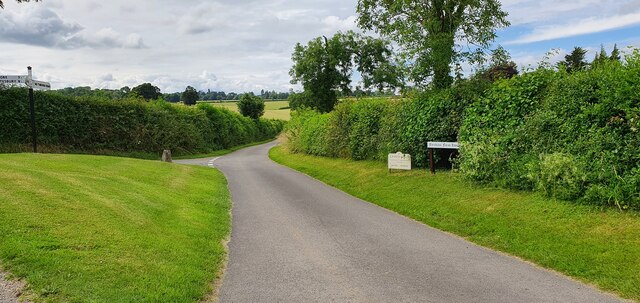
Little Wood is a picturesque forest located in the county of Wiltshire, England. Nestled within the rolling countryside, this woodland covers an area of approximately 50 acres. It is situated near the village of Wood, hence its name, and is a popular destination for nature enthusiasts and outdoor adventurers.

The forest boasts a diverse range of tree species, including oak, beech, and ash, creating a lush and vibrant ecosystem. The dense canopy provides a haven for various bird species, making it a haven for birdwatchers. Additionally, the forest floor is teeming with native flora, such as bluebells and wild garlic, adding to its natural beauty.

Little Wood offers a network of well-maintained footpaths and trails, allowing visitors to explore the forest at their leisure. These paths wind through the ancient trees, providing a tranquil and serene ambiance. Along the way, visitors may encounter wildlife, such as deer, squirrels, and even the occasional badger.

The forest is also home to a small pond, attracting a variety of aquatic creatures, including frogs and newts. This pond serves as a focal point for many visitors, as it offers a peaceful spot to relax and observe nature.

Little Wood is easily accessible, with a car park located nearby for visitors' convenience. The forest is open to the public throughout the year, providing a tranquil escape from the hustle and bustle of daily life. Whether it's a leisurely stroll, birdwatching, or simply enjoying the beauty of nature, Little Wood offers a delightful experience for all who visit.

If you have any feedback on the listing, please let us know in the comments section below.

Little Wood Images

Images are sourced within 2km of 50.956173/-2.0782829 or Grid Reference ST9417. Thanks to Geograph Open Source API. All images are credited.

Minor road outside Farnham
Parkland east of Oakley Lane Part of Rushmore Park.
Parkland east of Oakley Lane
Part of Rushmore Park.
B3081 looking east Heading towards Sixpenny Handley.
B3081 looking east
Heading towards Sixpenny Handley.
Rushmore Park, avenue The remains of a once fine avenue of beech trees, at the southern entrance to the estate.
Rushmore Park, avenue
The remains of a once fine avenue of beech trees, at the southern entrance to the estate.
Rushmore Park, timber Beech trunks, awaiting collection by the roadside.
Rushmore Park, timber
Beech trunks, awaiting collection by the roadside.
Rushmore Park, footpath Skirting woodland, towards Shermel Gate.
Rushmore Park, footpath
Skirting woodland, towards Shermel Gate.
Rushmore Park, avenue A once fine avenue of beech trees leading from South Lodge. Several have disappeared or are in poor condition.
Rushmore Park, avenue
A once fine avenue of beech trees leading from South Lodge. Several have disappeared or are in poor condition.
Rushmore Park, platform Possibly used for watching equestrian events.
Rushmore Park, platform
Possibly used for watching equestrian events.
Rushmore Park, gate Entering Pollards Wood, on the path to Shermel Gate.
Rushmore Park, gate
Entering Pollards Wood, on the path to Shermel Gate.
Rushmore Park, footpath Through Pollards Wood, on the way to Shermel Gate; part of Hardy Way.
Rushmore Park, footpath
Through Pollards Wood, on the way to Shermel Gate; part of Hardy Way.
Rushmore Park, bluebells Wild bluebells under, unusually, a screen of conifers in Uddens Coppice.
Rushmore Park, bluebells
Wild bluebells under, unusually, a screen of conifers in Uddens Coppice.
Rushmore Park, marker On the path through Uddens Coppice towards Shermel Gate; on Hardy Way.
Rushmore Park, marker
On the path through Uddens Coppice towards Shermel Gate; on Hardy Way.
Rushmore Park, bluebell wood Wild bluebells in Brookes Coppice.
Rushmore Park, bluebell wood
Wild bluebells in Brookes Coppice.
Rushmore Park, golf course Part of an extensive 18-hole course: <span class="nowrap"><a title="http://www.rushmoregolfclub.co.uk/cms/" rel="nofollow ugc noopener" href="http://www.rushmoregolfclub.co.uk/cms/">Link</a><img style="margin-left:2px;" alt="External link" title="External link - shift click to open in new window" src="https://s1.geograph.org.uk/img/external.png" width="10" height="10"/></span>
Rushmore Park, golf course
Part of an extensive 18-hole course: LinkExternal link
Rushmore Park, dewpond Used by the local sheep.
Rushmore Park, dewpond
Used by the local sheep.
Rushmore Park, bluebells Wild bluebells next to the golf course.
Rushmore Park, bluebells
Wild bluebells next to the golf course.
Rushmore Park, golf course An extensive 18-hole course: <span class="nowrap"><a title="http://www.rushmoregolfclub.co.uk/cms/" rel="nofollow ugc noopener" href="http://www.rushmoregolfclub.co.uk/cms/">Link</a><img style="margin-left:2px;" alt="External link" title="External link - shift click to open in new window" src="https://s1.geograph.org.uk/img/external.png" width="10" height="10"/></span>
Rushmore Park, golf course
An extensive 18-hole course: LinkExternal link
Rushmore Park, gateway Also on the Wiltshire/Dorset boundary.
Rushmore Park, gateway
Also on the Wiltshire/Dorset boundary.
Show me another place!

Little Wood is located at Grid Ref: ST9417 (Lat: 50.956173, Lng: -2.0782829)

Unitary Authority: Wiltshire

Police Authority: Wiltshire

What 3 Words

///peanut.suggested.sheep. Near Pimperne, Dorset

Related Wikis

King John's House, Tollard Royal

King John's House is a former manor house in the south Wiltshire village of Tollard Royal, England. Just south of the church, the building has at its core...

Tollard Royal

Tollard Royal is a village and civil parish on Cranborne Chase, Wiltshire, England. The parish is on Wiltshire's southern boundary with Dorset and the...

Larmer Tree Festival

Larmer Tree Festival was a three-day music, comedy and arts festival held annually from 1990 until 2019 at the Larmer Tree Gardens, near Tollard Royal...

Larmer Tree Gardens

The Larmer Tree Gardens near Tollard Royal in south Wiltshire, England, were created by landowner Augustus Pitt Rivers in 1880 as pleasure grounds for...

South Lodge Camp

South Lodge Camp is an archaeological site of the Bronze Age, about 0.6 miles (1.0 km) south-east of the village of Tollard Royal, in Wiltshire, England...

Sandroyd School

Sandroyd School is an independent co-educational preparatory school for day and boarding pupils aged 2 to 13 in the south of Wiltshire, England. The school...

Woodcutts Settlement

Woodcutts Settlement is an archaeological site of the late Iron Age and Romano-British period on Cranborne Chase, England. It is situated about 1 mile...

Rotherley Down Settlement

Rotherley Down Settlement is an archaeological site of the late Iron Age and Romano-British period on Cranborne Chase, England. It is about 1.5 miles...

Nearby Amenities

Located within 500m of 50.956173,-2.0782829
Tollard Royal
Place: village
Lat/Long: 50.9594291/-2.07987
Crossing
Lat/Long: 50.9589478/-2.0803908
Crossing
Lat/Long: 50.9589899/-2.0792593
Material: wood
Power: pole
Source: bing
Lat/Long: 50.9572291/-2.0850933
Material: wood
Poles: bipole
Power: pole
Source: bing
Lat/Long: 50.9579691/-2.0833928
Material: wood
Power: pole
Source: bing
Lat/Long: 50.953136/-2.0741821
Material: wood
Power: pole
Source: bing
Lat/Long: 50.9538085/-2.0746488
Material: wood
Power: pole
Source: bing
Lat/Long: 50.9539031/-2.0750833
Material: wood
Power: pole
Source: bing
Lat/Long: 50.954192/-2.0742921
Material: wood
Power: pole
Source: bing
Lat/Long: 50.9542005/-2.0753998
Material: wood
Power: pole
Source: bing
Lat/Long: 50.9545435/-2.0756547
Material: wood
Power: pole
Source: bing
Lat/Long: 50.9547496/-2.0743457
Material: wood
Power: pole
Source: bing
Lat/Long: 50.9548915/-2.075947
Material: wood
Power: pole
Source: bing
Lat/Long: 50.9551416/-2.0735035
Material: wood
Power: pole
Source: bing
Lat/Long: 50.9555285/-2.0726372
Material: wood
Power: pole
Source: bing
Lat/Long: 50.9555758/-2.0750377
Historic: memorial
Memorial: war_memorial
Lat/Long: 50.9596013/-2.0805706
Public Bookcase
Tollard Tardis
Defibrillator
Access: yes
Booth: K6
Covered: booth
Defibrillator Location: inside old red phone box in Tollard Royal
Disused Amenity: telephone
Emergency: defibrillator
Man Made: telephone_box
Public Bookcase Type: phone_box
Lat/Long: 50.9597026/-2.0807114
Post Box
Post Box Mounting: brick_pillar
Post Box Type: wall
Royal Cypher: GVIR
Royal Cypher Wikidata: Q33102169
Lat/Long: 50.9597778/-2.0805941
Bench
Lat/Long: 50.9597892/-2.0805699
The data included in this document is from www.openstreetmap.org. The data is made available under ODbL.

Have you been to Little Wood?

Leave your review of Little Wood below (or comments, questions and feedback).