Leys Coppice

Wood, Forest in Wiltshire

England

Leys Coppice

Minor road outside Farnham
Minor road outside Farnham Credit: Helen Steed

Leys Coppice is a woodland located in the county of Wiltshire, England. Situated near the village of Box, it covers an area of approximately 20 acres. The coppice is part of the larger Box Woodland complex, which extends over 100 acres in total.

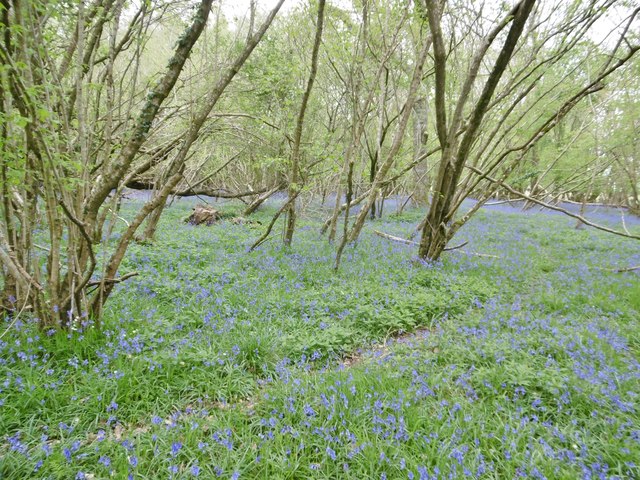
Leys Coppice is predominantly composed of native broadleaf trees, including oak, ash, beech, and hazel. The wood is characterized by its dense canopy and diverse undergrowth, providing a habitat for a wide range of flora and fauna. Bluebells, wild garlic, and wood anemones are common wildflowers found in the coppice during the spring season.

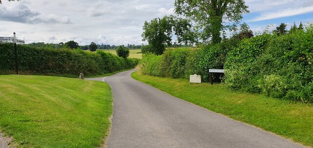
The woodland is crisscrossed by a network of footpaths, allowing visitors to explore its natural beauty. These paths lead to various points of interest, such as an old stone quarry and a small stream that runs through the wood. The tranquility and seclusion of the coppice make it a popular spot for nature enthusiasts, walkers, and birdwatchers.

Leys Coppice also has historical significance. It was once part of the Box Estate and was managed as a coppice woodland for timber production. Today, the wood is managed by local conservation organizations, with a focus on preserving its natural habitat and promoting biodiversity.

Overall, Leys Coppice is a picturesque woodland in Wiltshire, offering visitors a peaceful retreat in nature and a chance to experience the beauty and diversity of a traditional English woodland.

If you have any feedback on the listing, please let us know in the comments section below.

Leys Coppice Images

Images are sourced within 2km of 50.954919/-2.0846589 or Grid Reference ST9417. Thanks to Geograph Open Source API. All images are credited.

Minor road outside Farnham
Parkland east of Oakley Lane Part of Rushmore Park.
Parkland east of Oakley Lane
Part of Rushmore Park.
Rushmore Park, avenue The remains of a once fine avenue of beech trees, at the southern entrance to the estate.
Rushmore Park, avenue
The remains of a once fine avenue of beech trees, at the southern entrance to the estate.
Rushmore Park, timber Beech trunks, awaiting collection by the roadside.
Rushmore Park, timber
Beech trunks, awaiting collection by the roadside.
Rushmore Park, footpath Skirting woodland, towards Shermel Gate.
Rushmore Park, footpath
Skirting woodland, towards Shermel Gate.
Rushmore Park, avenue A once fine avenue of beech trees leading from South Lodge. Several have disappeared or are in poor condition.
Rushmore Park, avenue
A once fine avenue of beech trees leading from South Lodge. Several have disappeared or are in poor condition.
Rushmore Park, platform Possibly used for watching equestrian events.
Rushmore Park, platform
Possibly used for watching equestrian events.
Rushmore Park, gate Entering Pollards Wood, on the path to Shermel Gate.
Rushmore Park, gate
Entering Pollards Wood, on the path to Shermel Gate.
Rushmore Park, footpath Through Pollards Wood, on the way to Shermel Gate; part of Hardy Way.
Rushmore Park, footpath
Through Pollards Wood, on the way to Shermel Gate; part of Hardy Way.
Rushmore Park, bluebells Wild bluebells under, unusually, a screen of conifers in Uddens Coppice.
Rushmore Park, bluebells
Wild bluebells under, unusually, a screen of conifers in Uddens Coppice.
Rushmore Park, marker On the path through Uddens Coppice towards Shermel Gate; on Hardy Way.
Rushmore Park, marker
On the path through Uddens Coppice towards Shermel Gate; on Hardy Way.
Rushmore Park, bluebell wood Wild bluebells in Brookes Coppice.
Rushmore Park, bluebell wood
Wild bluebells in Brookes Coppice.
Rushmore Park, golf course Part of an extensive 18-hole course: <span class="nowrap"><a title="http://www.rushmoregolfclub.co.uk/cms/" rel="nofollow ugc noopener" href="http://www.rushmoregolfclub.co.uk/cms/">Link</a><img style="margin-left:2px;" alt="External link" title="External link - shift click to open in new window" src="https://s1.geograph.org.uk/img/external.png" width="10" height="10"/></span>
Rushmore Park, golf course
Part of an extensive 18-hole course: LinkExternal link
Rushmore Park, dewpond Used by the local sheep.
Rushmore Park, dewpond
Used by the local sheep.
Rushmore Park, bluebells Wild bluebells next to the golf course.
Rushmore Park, bluebells
Wild bluebells next to the golf course.
Rushmore Park, golf course An extensive 18-hole course: <span class="nowrap"><a title="http://www.rushmoregolfclub.co.uk/cms/" rel="nofollow ugc noopener" href="http://www.rushmoregolfclub.co.uk/cms/">Link</a><img style="margin-left:2px;" alt="External link" title="External link - shift click to open in new window" src="https://s1.geograph.org.uk/img/external.png" width="10" height="10"/></span>
Rushmore Park, golf course
An extensive 18-hole course: LinkExternal link
Woodcutts, sheep grazing
Woodcutts, bluebell wood Pollards Wood, also a good location for early purple orchids.
Woodcutts, bluebell wood
Pollards Wood, also a good location for early purple orchids.
Show me another place!

Leys Coppice is located at Grid Ref: ST9417 (Lat: 50.954919, Lng: -2.0846589)

Unitary Authority: Wiltshire

Police Authority: Wiltshire

What 3 Words

///belief.roofer.observers. Near Pimperne, Dorset

Related Wikis

Larmer Tree Festival

Larmer Tree Festival was a three-day music, comedy and arts festival held annually from 1990 until 2019 at the Larmer Tree Gardens, near Tollard Royal...

Larmer Tree Gardens

The Larmer Tree Gardens near Tollard Royal in south Wiltshire, England, were created by landowner Augustus Pitt Rivers in 1880 as pleasure grounds for...

King John's House, Tollard Royal

King John's House is a former manor house in the south Wiltshire village of Tollard Royal, England. Just south of the church, the building has at its core...

Tollard Royal

Tollard Royal is a village and civil parish on Cranborne Chase, Wiltshire, England. The parish is on Wiltshire's southern boundary with Dorset and the...

South Lodge Camp

South Lodge Camp is an archaeological site of the Bronze Age, about 0.6 miles (1.0 km) south-east of the village of Tollard Royal, in Wiltshire, England...

Sandroyd School

Sandroyd School is an independent co-educational preparatory school for day and boarding pupils aged 2 to 13 in the south of Wiltshire, England. The school...

Rotherley Down Settlement

Rotherley Down Settlement is an archaeological site of the late Iron Age and Romano-British period on Cranborne Chase, England. It is about 1.5 miles...

Woodcutts Settlement

Woodcutts Settlement is an archaeological site of the late Iron Age and Romano-British period on Cranborne Chase, England. It is situated about 1 mile...

Nearby Amenities

Located within 500m of 50.954919,-2.0846589
Leisure: playground
Lat/Long: 50.9513862/-2.0817376
Material: wood
Power: pole
Source: bing
Lat/Long: 50.954867/-2.0904712
Material: wood
Power: pole
Source: bing
Lat/Long: 50.9554432/-2.0890872
Material: wood
Power: pole
Source: bing
Lat/Long: 50.9559872/-2.087789
Material: wood
Power: pole
Source: bing
Lat/Long: 50.9564384/-2.0867992
Material: wood
Power: pole
Source: bing
Lat/Long: 50.9572291/-2.0850933
Material: wood
Poles: bipole
Power: pole
Source: bing
Lat/Long: 50.9579691/-2.0833928
Tollard Park Equestrian Centre
Source Name: OS_OpenData_StreetView
Lat/Long: 50.9560069/-2.0893849
Material: wood
Power: pole
Lat/Long: 50.9562743/-2.0891844
Material: wood
Power: pole
Lat/Long: 50.9567596/-2.0901413
Entrance: yes
Lat/Long: 50.9522112/-2.0833029
Cafe
Coffee Grove Café
Lat/Long: 50.951455/-2.0826565
Grotto
Man Made: yes
Lat/Long: 50.951185/-2.083782
Defibrillator
Emergency: defibrillator
Lat/Long: 50.9514034/-2.0826315
The data included in this document is from www.openstreetmap.org. The data is made available under ODbL.

Have you been to Leys Coppice?

Leave your review of Leys Coppice below (or comments, questions and feedback).