Angus Wood

Wood, Forest in Dorset

England

Angus Wood

Red Lion Yard Yard at the back of the former Red Lion Inn on Market Place.
Red Lion Yard Credit: Ian Capper

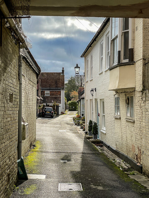
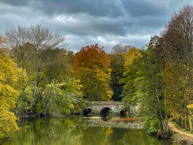
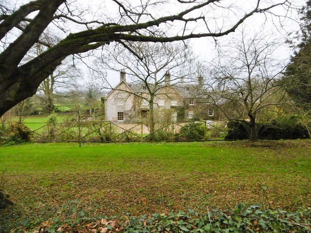
Angus Wood, located in Dorset, England, is a picturesque forest known for its natural beauty and diverse flora and fauna. Spanning over a vast area, the wood is a popular destination for nature enthusiasts, hikers, and wildlife lovers.

The forest is characterized by its dense woodland, consisting primarily of deciduous and conifer trees. The towering oak, beech, and birch trees create a stunning canopy that provides shade and shelter for the various species that call Angus Wood their home. The forest floor is adorned with a carpet of wildflowers, ferns, and mosses, offering a vibrant and colorful landscape.

Angus Wood is also home to a rich and diverse wildlife population. Birdwatchers flock to the area to catch a glimpse of the numerous species that inhabit the forest, including woodpeckers, owls, and various songbirds. Mammals such as deer, foxes, and badgers can also be spotted in their natural habitats.

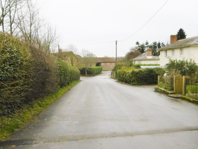
The wood offers a network of well-marked trails, making it an ideal location for outdoor activities such as hiking, cycling, and horseback riding. The serene atmosphere and stunning scenery provide visitors with a peaceful and immersive experience in nature.

Additionally, Angus Wood is a site of historical importance, with evidence of human habitation dating back centuries. Archaeological finds suggest that the area was occupied during the Iron Age and Roman periods. Ruins of ancient settlements and burial mounds can still be found within the wood, adding to its cultural significance.

Overall, Angus Wood in Dorset is a captivating destination that offers a unique blend of natural beauty, wildlife, and historical significance, making it an ideal spot for nature lovers and history enthusiasts alike.

If you have any feedback on the listing, please let us know in the comments section below.

Angus Wood Images

Images are sourced within 2km of 50.85848/-2.1580364 or Grid Reference ST8806. Thanks to Geograph Open Source API. All images are credited.

Red Lion Yard Yard at the back of the former Red Lion Inn on Market Place.
Red Lion Yard
Yard at the back of the former Red Lion Inn on Market Place.
River Stour River Stour at Blandford Forum, viewed from Mortain Bridge footbridge, with the 1783 Blandford Bridge in the background.
River Stour
River Stour at Blandford Forum, viewed from Mortain Bridge footbridge, with the 1783 Blandford Bridge in the background.
Remembrance display Remembrance display in front of the early 18th Century Church of St Peter and St Paul.
Remembrance display
Remembrance display in front of the early 18th Century Church of St Peter and St Paul.
Remembrance display Remembrance display in front of the early 18th Century Church of St Peter and St Paul.
Remembrance display
Remembrance display in front of the early 18th Century Church of St Peter and St Paul.
Legion House Mid 18th Century house in Church Lane, now occupied by the British Legion.  Grade I listed - see <span class="nowrap"><a title="www.historicengland.org.uk/listing/the-list/list-entry/1152976" rel="nofollow ugc noopener" href="http://www.historicengland.org.uk/listing/the-list/list-entry/1152976">Link</a><img style="margin-left:2px;" alt="External link" title="External link - shift click to open in new window" src="https://s1.geograph.org.uk/img/external.png" width="10" height="10"/></span>.  The gate and railings are separately grade II listed - see <span class="nowrap"><a title="www.historicengland.org.uk/listing/the-list/list-entry/1108652" rel="nofollow ugc noopener" href="http://www.historicengland.org.uk/listing/the-list/list-entry/1108652">Link</a><img style="margin-left:2px;" alt="External link" title="External link - shift click to open in new window" src="https://s1.geograph.org.uk/img/external.png" width="10" height="10"/></span>.
Legion House
Mid 18th Century house in Church Lane, now occupied by the British Legion. Grade I listed - see LinkExternal link. The gate and railings are separately grade II listed - see LinkExternal link.
1 Market Place 18th Century building in Market Place.  Grade II* listed - see <span class="nowrap"><a title="www.historicengland.org.uk/listing/the-list/list-entry/1108683" rel="nofollow ugc noopener" href="http://www.historicengland.org.uk/listing/the-list/list-entry/1108683">Link</a><img style="margin-left:2px;" alt="External link" title="External link - shift click to open in new window" src="https://s1.geograph.org.uk/img/external.png" width="10" height="10"/></span>.
1 Market Place
18th Century building in Market Place. Grade II* listed - see LinkExternal link.
Blandford Community Hospital
Hill Top Roundabout A350/A354
Badger  Roundabout A350/A354
Badger Roundabout A350/A354
Benchmark on #35 Salisbury Road, Blandford Forum Ordnance Survey benchmark on commercial building. More information can be found here: <span class="nowrap"><a title="https://www.bench-marks.org.uk/bm33527" rel="nofollow ugc noopener" href="https://www.bench-marks.org.uk/bm33527">Link</a><img style="margin-left:2px;" alt="External link" title="External link - shift click to open in new window" src="https://s1.geograph.org.uk/img/external.png" width="10" height="10"/></span>
Benchmark on #35 Salisbury Road, Blandford Forum
Ordnance Survey benchmark on commercial building. More information can be found here: LinkExternal link
Southover Close
Southover Close
Entrance to Blandford St Mary CE Primary School
Southover Close
Southover Close
Langton Long, All Saints C19 parish church, listed by Historic England (Grade II): <span class="nowrap"><a title="http://www.britishlistedbuildings.co.uk/en-103723-church-of-all-saints-langton-long-blandf" rel="nofollow ugc noopener" href="http://www.britishlistedbuildings.co.uk/en-103723-church-of-all-saints-langton-long-blandf">Link</a><img style="margin-left:2px;" alt="External link" title="External link - shift click to open in new window" src="https://s1.geograph.org.uk/img/external.png" width="10" height="10"/></span>
Langton Long, All Saints
C19 parish church, listed by Historic England (Grade II): LinkExternal link
Langton Long, former rectory C18/19 former rectory, behind the parish church <a href="https://www.geograph.org.uk/photo/4766217">ST8905 : Langton Long, All Saints</a>; listed by Historic England <span class="nowrap"><a title="http://www.imagesofengland.org.uk/Details/Default.aspx?id=103722&mode=adv" rel="nofollow ugc noopener" href="http://www.imagesofengland.org.uk/Details/Default.aspx?id=103722&mode=adv">Link</a><img style="margin-left:2px;" alt="External link" title="External link - shift click to open in new window" src="https://s1.geograph.org.uk/img/external.png" width="10" height="10"/></span>
Langton Long, former rectory
C18/19 former rectory, behind the parish church ST8905 : Langton Long, All Saints; listed by Historic England LinkExternal link
Langton Long, Langton Farm
Langton Long, South Lodge Former lodge to Langton House, now private; early C19, listed by Historic England: <span class="nowrap"><a title="http://www.imagesofengland.org.uk/Details/Default.aspx?id=103724&mode=adv" rel="nofollow ugc noopener" href="http://www.imagesofengland.org.uk/Details/Default.aspx?id=103724&mode=adv">Link</a><img style="margin-left:2px;" alt="External link" title="External link - shift click to open in new window" src="https://s1.geograph.org.uk/img/external.png" width="10" height="10"/></span>
Langton Long, South Lodge
Former lodge to Langton House, now private; early C19, listed by Historic England: LinkExternal link
Footbridge over A350, Blandford Forum by-pass
Show me another place!

Angus Wood is located at Grid Ref: ST8806 (Lat: 50.85848, Lng: -2.1580364)

Unitary Authority: Dorset

Police Authority: Dorset

What 3 Words

///funnels.clown.revealing. Near Blandford Forum, Dorset

Nearby Locations

Angus Wood Blandford Forum

Related Wikis

Blandford Forum railway station

Blandford Forum railway station was a station on the Somerset & Dorset Joint Railway which served the town of Blandford Forum. == History == Originally...

Coombs Ditch Hundred

Coombs Ditch Hundred was a hundred in the county of Dorset, England, containing the following parishes: Anderson Blandford Forum (borough from 1605) Blandford...

Pump House, Blandford Forum

The Pump House, Blandford Forum, Dorset, England, is an 18th-century water source erected in 1760 in commemoration of a fire which almost destroyed the...

Blandford Forum Town Hall

Blandford Forum Town Hall is a municipal building in the Market Place in Blandford Forum, Dorset, England. The 18th-century structure, which was the meeting...

Blandford Forum

Blandford Forum ( BLAN-fərd) is a market town in Dorset, England, by the River Stour 13 miles (21 kilometres) northwest of Poole. It had a population of...

The Blandford School

The Blandford School is a coeducational secondary school located in Blandford Forum in the English county of Dorset.It is a voluntary controlled school...

Langton Long Blandford

Langton Long Blandford is a small village and civil parish in the county of Dorset in southern England. It is sited by the River Stour, approximately 3...

Blandford St Mary

Blandford St Mary is a village and civil parish in the North Dorset district of Dorset, England. The village is on the south bank of the River Stour, immediately...

Nearby Amenities

Located within 500m of 50.85848,-2.1580364
Blandford Forum
Alt Name: Blandford
Is In: Dorset, England, UK
Place: town
Lat/Long: 50.8576197/-2.1631125
Fixme: This telephone box appears to be missing on Street Level Imagery. Please confirm.
Mapillary: 850983942198694
Operator: BT
Operator Wikidata: Q593786
Removed Amenity: telephone
Survey Date: 2021-08-16
Lat/Long: 50.8597892/-2.1634046
Post Box
Brand: Royal Mail
Brand Wikidata: Q638098
Operator: Royal Mail
Operator Wikidata: Q638098
Post Box Type: pillar
Ref GB Uprn: 10015277970
Lat/Long: 50.8597784/-2.1633425
Turning Circle
Lat/Long: 50.8595019/-2.1538613
Turning Circle
Lat/Long: 50.8596351/-2.1524925
Turning Circle
Lat/Long: 50.860071/-2.1525678
Turning Circle
Lat/Long: 50.8605256/-2.151793
Post Box
Brand: Royal Mail
Brand Wikidata: Q638098
Collection Times: Mo-Fr 09:00; Sa 07:00
Operator: Royal Mail
Operator Wikidata: Q638098
Post Box Type: pillar
Ref: DT11 21D
Ref GB Uprn: 10015709590
Royal Cypher: GR
Royal Cypher Wikidata: Q33102273
Lat/Long: 50.8571677/-2.1578265
Post Box
Brand: Royal Mail
Brand Wikidata: Q638098
Collection Times: Mo-Fr 09:00; Sa 07:00
Operator: Royal Mail
Operator Wikidata: Q638098
Post Box Type: lamp
Ref: DT11 170D
Ref GB Uprn: 10015459013
Royal Cypher: GVIR
Royal Cypher Wikidata: Q33102169
Lat/Long: 50.8553208/-2.1568667
Turning Circle
Lat/Long: 50.8565251/-2.1540991
Turning Circle
Lat/Long: 50.8563487/-2.1554831
Recycling
Location: overground
Recycling Type: container
Lat/Long: 50.8556794/-2.1606673
Taxi
Lat/Long: 50.8561456/-2.1632871
Traffic Signals
Crossing: traffic_signals
Crossing Ref: pelican
Cycleway: asl
Traffic Signals: signal
Lat/Long: 50.8569432/-2.1596309
Bicycle Parking
Covered: no
Lat/Long: 50.8568561/-2.1632471
Traffic Signals
Traffic Signals: signal
Lat/Long: 50.8570455/-2.1600854
Traffic Signals
Crossing: traffic_signals
Crossing Ref: pelican
Cycleway: asl
Traffic Signals: signal
Lat/Long: 50.8568205/-2.1593992
Traffic Signals
Button Operated: yes
Crossing: traffic_signals
Crossing Ref: pelican
Cycleway: asl
Tactile Paving: yes
Traffic Signals: signal
Traffic Signals Sound: no
Traffic Signals Vibration: no
Lat/Long: 50.8569884/-2.1591757
Traffic Signals
Crossing: traffic_signals
Crossing Ref: pelican
Cycleway: asl
Traffic Signals: signal
Lat/Long: 50.8571092/-2.1594004
Blandford Fashion Museum
Addr Postcode: DT11 7AA
Operator: Cavalcade Of Costume
Phone: +44 1258 453006
Tourism: museum
Website: http://www.theblandfordfashionmuseum.com
Wikidata: Q113370121
Lat/Long: 50.857047/-2.1645778
Give Way
Direction: backward
Lat/Long: 50.8599254/-2.1553709
Give Way
Direction: forward
Lat/Long: 50.859914/-2.1552194
Railway: crossing
Lat/Long: 50.8561821/-2.1596732
M&Co
Addr City: Blandford Forum
Addr Street: East Street
Brand: M&Co
Brand Wikidata: Q6711808
Brand Wikipedia: en:M&Co.
Shop: clothes
Lat/Long: 50.8560601/-2.16265
Pharmacy
Boots
Addr City: Blandford Forum
Addr Street: East Street
Brand: Boots
Brand Wikidata: Q6123139
Brand Wikipedia: en:Boots UK
Healthcare: pharmacy
Lat/Long: 50.8560025/-2.1628378
Cards & Things
Addr City: Blandford Forum
Addr Street: East Street
Shop: gift
Lat/Long: 50.8559771/-2.162937
Bus Stop
Blandford Market Place
Bench: no
Bin: no
Bus: yes
Lit: no
Local Ref: A
Public Transport: platform
Shelter: no
Tactile Paving: no
Lat/Long: 50.8559169/-2.1638419
Bus Stop
St Leonard's Court
Bench: no
Bin: no
Bus: yes
Naptan AtcoCode: 1200POA10393
Naptan Bearing: E
Naptan BusStopType: CUS
Naptan CommonName: Fishers Close
Naptan Indicator: E-bound
Naptan NaptanCode: dorawajd
Naptan Street: Wimborne Road
Naptan Verified: no
Public Transport: platform
Shelter: no
Tactile Paving: no
Lat/Long: 50.8572172/-2.1584335
Bus Stop
Fairfield Road
Bus: yes
Naptan AtcoCode: 1200POA10376
Naptan Bearing: NE
Naptan CommonName: Fairfield Road
Naptan Indicator: NE-bound
Naptan NaptanCode: dorawadj
Naptan Street: Salisbury Road
Naptan Verified: no
Public Transport: platform
Lat/Long: 50.8603919/-2.1624258
Bus Stop
Fairfield Road
Bus: yes
Naptan AtcoCode: 1200POA10375
Naptan Bearing: SW
Naptan CommonName: Fairfield Road
Naptan Indicator: opp
Naptan NaptanCode: dorawadm
Naptan Street: Salisbury Road
Naptan Verified: no
Public Transport: platform
Lat/Long: 50.860317/-2.1623598
Bus Stop
St Leonard's Avenue
Bus: yes
Naptan AtcoCode: 1200POA10385
Naptan Bearing: SW
Naptan CommonName: Queens Road
Naptan Indicator: SW-bound
Naptan NaptanCode: dorawata
Naptan Street: St Leonard's Avenue
Naptan Verified: no
Public Transport: platform
Lat/Long: 50.8601037/-2.154724
Bus Stop
Bayfran Way
Bench: no
Bin: no
Bus: yes
Lit: no
Naptan AtcoCode: 1200DOA91012
Naptan Bearing: SW
Naptan CommonName: Bayfran Way
Naptan Indicator: SW-bound
Naptan NaptanCode: dordtapj
Naptan Street: St Leonards Avenue
Naptan Verified: no
Public Transport: platform
Shelter: no
Tactile Paving: no
Lat/Long: 50.8585302/-2.1571787
Noexit: yes
Lat/Long: 50.860887/-2.1526653
Noexit: yes
Lat/Long: 50.8595079/-2.1546581
Noexit: yes
Lat/Long: 50.8606842/-2.1529908
Noexit: yes
Lat/Long: 50.86045/-2.1531981
Traffic Signals
Crossing: traffic_signals
Crossing Ref: pelican
Traffic Signals: signal
Lat/Long: 50.8563072/-2.1623358
Crossing
Traffic Calming: table
Lat/Long: 50.8560199/-2.1631966
Traffic Signals
Crossing: traffic_signals
Crossing Ref: pelican
Lat/Long: 50.8597075/-2.1632411
Give Way
Lat/Long: 50.8594393/-2.1630891
Traffic Signals
Crossing: traffic_signals
Crossing Ref: pelican
Lat/Long: 50.8595601/-2.1633197
Traffic Signals
Crossing: traffic_signals
Crossing Ref: pelican
Lat/Long: 50.8597417/-2.1633764
Traffic Signals
Crossing: traffic_signals
Crossing Ref: pelican
Lat/Long: 50.8597203/-2.163401
Give Way
Lat/Long: 50.8569211/-2.1601669
Traffic Signals
Crossing: traffic_signals
Crossing Ref: pelican
Traffic Signals: signal
Lat/Long: 50.8570254/-2.1601907
Traffic Signals
Crossing: traffic_signals
Crossing Ref: pelican
Traffic Signals: signal
Lat/Long: 50.857035/-2.1601323
Turning Circle
Lat/Long: 50.8615627/-2.162803
Entrance: main
Lat/Long: 50.8561784/-2.1641138
Library
Blandford Library
Wikidata: Q55173465
Lat/Long: 50.8567618/-2.1631086
Vending Machine
Vending: parking_tickets
Lat/Long: 50.8562063/-2.1634226
Bench
Lat/Long: 50.8573612/-2.1633698
Bench
Lat/Long: 50.8572211/-2.1632909
Bench
Lat/Long: 50.8573197/-2.1628167
Bench
Lat/Long: 50.857493/-2.1629268
Entrance: yes
Lat/Long: 50.857493/-2.1633328
Blandford Rugby Club
Leisure: pitch
Sport: rugby_union
Lat/Long: 50.8556333/-2.1630363
Noexit: yes
Lat/Long: 50.8602322/-2.1550139
Noexit: yes
Lat/Long: 50.8600595/-2.1534101
Noexit: yes
Lat/Long: 50.8599176/-2.1562999
Noexit: yes
Lat/Long: 50.8601373/-2.1572116
Noexit: yes
Lat/Long: 50.8598701/-2.1578337
Noexit: yes
Lat/Long: 50.8598574/-2.1580103
Noexit: yes
Lat/Long: 50.8597268/-2.1582694
Noexit: yes
Lat/Long: 50.8596848/-2.1580894
Noexit: yes
Lat/Long: 50.8595821/-2.1582316
Addr City: Blandford Forum
Addr Housenumber: 11
Addr Street: Barnes Close
Lat/Long: 50.8623996/-2.1545425
Addr City: Blandford Forum
Addr Housenumber: 1
Addr Street: Barnes Homes
Lat/Long: 50.8626163/-2.1581264
Addr City: Blandford Forum
Addr Housenumber: 7
Addr Street: Barnes Homes
Lat/Long: 50.862905/-2.1577545
Addr City: Blandford Forum
Addr Housenumber: 9
Addr Street: Barnes Homes
Lat/Long: 50.8627824/-2.1575158
Addr City: Blandford Forum
Addr Housenumber: 20
Addr Street: Barnes Homes
Lat/Long: 50.8624841/-2.1579002
Addr City: Blandford Forum
Addr Housenumber: 21
Addr Street: Barnes Homes
Lat/Long: 50.8625505/-2.1580296
Addr City: Blandford Forum
Addr Housenumber: 22
Addr Street: Barnes Homes
Lat/Long: 50.8625425/-2.1582325
Addr City: Blandford Forum
Addr Housenumber: 27
Addr Street: Barnes Homes
Lat/Long: 50.8626751/-2.1584865
Addr City: Blandford Forum
Addr Housenumber: 1
Addr Street: St Leonard's Court
Lat/Long: 50.8573405/-2.1581001
Addr City: Blandford Forum
Addr Housenumber: 7
Addr Street: St Leonard's Court
Lat/Long: 50.8575373/-2.1578041
Addr City: Blandford Forum
Addr Housenumber: 11
Addr Street: St Leonard's Court
Lat/Long: 50.8575573/-2.1582375
Addr City: Blandford Forum
Addr Housenumber: 1
Addr Street: Union Court
Lat/Long: 50.8620224/-2.1606202
Addr City: Blandford Forum
Addr Housenumber: 9
Addr Street: Union Court
Lat/Long: 50.8618933/-2.1607922
Addr City: Blandford Forum
Addr Housenumber: 1
Addr Street: Old Castleman House
Lat/Long: 50.861817/-2.1608828
Addr City: Blandford Forum
Addr Housenumber: 7
Addr Street: Old Castleman House
Lat/Long: 50.8619051/-2.1611687
Addr City: Blandford Forum
Addr Housenumber: 3
Addr Street: Darcy Court
Lat/Long: 50.8606927/-2.1616323
Addr City: Blandford Forum
Addr Housenumber: 1
Addr Street: Darcy Court
Lat/Long: 50.860645/-2.1615624
Addr City: Blandford Forum
Addr Housenumber: 4
Addr Street: Darcy Court
Lat/Long: 50.8607797/-2.1615114
Addr City: Blandford Forum
Addr Housenumber: 7
Addr Street: Darcy Court
Lat/Long: 50.8606379/-2.1612906
Noexit: yes
Lat/Long: 50.8590745/-2.155391
Addr City: Blandford Forum
Addr Housenumber: 1
Addr Street: The Cedars
Lat/Long: 50.8596341/-2.1635772
Addr City: Blandford Forum
Addr Housenumber: 6
Addr Street: The Cedars
Lat/Long: 50.8597268/-2.1637506
Addr City: Blandford Forum
Addr Housenumber: 7
Addr Street: The Cedars
Lat/Long: 50.8597631/-2.1638409
Addr City: Blandford Forum
Addr Housenumber: 12
Addr Street: The Cedars
Lat/Long: 50.8595944/-2.1640674
Access: no
Barrier: bollard
Bicycle: yes
Bollard: fixed
Foot: yes
Lat/Long: 50.8611143/-2.1580848
Addr City: Blandford Forum
Addr Housenumber: 1
Addr Street: Princess Court
Lat/Long: 50.8612295/-2.1587596
Addr City: Blandford Forum
Addr Housenumber: 6
Addr Street: Princess Court
Lat/Long: 50.8611668/-2.1590751
Addr City: Blandford Forum
Addr Housenumber: 1
Addr Street: Alfred Mews
Lat/Long: 50.8594253/-2.1588254
Addr City: Blandford Forum
Addr Housenumber: 3
Addr Street: Alfred Mews
Lat/Long: 50.8593418/-2.1589485
Noexit: yes
Lat/Long: 50.8591696/-2.1592679
Barrier: bollard
Foot: yes
Lat/Long: 50.8590849/-2.1611565
Barrier: bollard
Foot: yes
Lat/Long: 50.8593431/-2.1607192
Addr City: Blandford Forum
Addr Housenumber: 1
Addr Street: Barnack Courtyard
Lat/Long: 50.8598425/-2.1605314
Addr City: Blandford Forum
Addr Housenumber: 3
Addr Street: Barnack Courtyard
Lat/Long: 50.8597502/-2.1603999
Addr City: Blandford Forum
Addr Housenumber: 1
Addr Street: Oakfield Court
Lat/Long: 50.8575306/-2.160551
Addr City: Blandford Forum
Addr Housenumber: 6
Addr Street: Oakfield Court
Lat/Long: 50.8576341/-2.1606641
Addr City: Blandford Forum
Addr Housenumber: 20
Addr Street: Oakfield Court
Lat/Long: 50.8578687/-2.1603621
Addr City: Blandford Forum
Addr Housenumber: 15
Addr Street: Oakfield Court
Lat/Long: 50.8578043/-2.1604839
Addr City: Blandford Forum
Addr Housenumber: 7
Addr Street: Oakfield Court
Lat/Long: 50.8577078/-2.1606777
Addr City: Blandford Forum
Addr Housenumber: 1
Addr Street: Albert Powis House
Lat/Long: 50.8574951/-2.160482
Addr City: Blandford Forum
Addr Housenumber: 8
Addr Street: Albert Powis House
Lat/Long: 50.8574295/-2.1601735
Traffic Signals
Traffic Signals: signal
Lat/Long: 50.8569623/-2.1591239
Post Box
Brand: Royal Mail
Brand Wikidata: Q638098
Collection Times: Mo-Fr 09:00; Sa 07:00
Operator: Royal Mail
Operator Wikidata: Q638098
Post Box Mounting: pier
Post Box Type: lamp
Ref: DT11 117D
Ref GB Uprn: 10015328787
Royal Cypher: EIIR
Royal Cypher Wikidata: Q33102113
Lat/Long: 50.8591996/-2.1598746
Post Box
Brand: Royal Mail
Brand Wikidata: Q638098
Collection Times: Mo-Fr 09:00; Sa 07:00
Operator: Royal Mail
Operator Wikidata: Q638098
Post Box Mounting: brick_pillar
Post Box Type: wall
Ref: DT11 137D
Ref GB Uprn: 10015376279
Royal Cypher: GVIR
Royal Cypher Wikidata: Q33102169
Lat/Long: 50.8597769/-2.1552663
Post Box
Collection Times: Mo-Fr 09:00; Sa 07:00
Operator: Royal Mail
Operator Wikidata: Q638098
Post Box Mounting: stone_wall
Post Box Type: wall
Ref: DT11 17D
Ref GB Uprn: 10015428910
Royal Cypher: EIIR
Royal Cypher Wikidata: Q33102113
Lat/Long: 50.8620197/-2.1594656
Bus Stop
St Leonard's Court
Bench: yes
Bin: no
Bus: yes
Lit: no
Naptan AtcoCode: 1200POA10394
Naptan Bearing: W
Naptan CommonName: Fishers Close
Naptan Indicator: W-bound
Naptan NaptanCode: dorawajg
Naptan Street: Wimborne Road
Naptan Verified: no
Public Transport: platform
Shelter: yes
Tactile Paving: no
Lat/Long: 50.8570616/-2.1586821
Off Camber
Addr City: Blandford Forum
Addr Housenumber: 38
Addr Postcode: DT11 7PR
Addr Street: Salisbury Street
Opening Hours: Mo-Sa 08:30-17:30
Payment American Express: yes
Payment Cash: yes
Payment Coins: yes
Payment Contactless: yes
Payment Credit Cards: yes
Payment Debit Cards: yes
Payment Mastercard: yes
Payment Visa: yes
Phone: +44 1258 458677
Service Bicycle Bicycle Sales And Service: yes
Service Bicycle Bicycle: yes
Service Bicycle Bike: yes
Service Bicycle Parts: yes
Service Bicycle Repair: yes
Service Bicycle Retail: yes
Service Bicycle Sales: yes
Service Bicycle Service: yes
Shop: bicycle
Website: https://www.offcamber.co.uk/
Lat/Long: 50.8573846/-2.1648615
Addr City: Blandford Forum
Addr Street: East Street
Disused Amenity: restaurant
Old Name: Jack Rabbits
Lat/Long: 50.8561168/-2.1624962
Addr City: Blandford Forum
Addr Housenumber: 45
Addr Street: East Street
Lat/Long: 50.856016/-2.1627885
Bella Carousel
Addr City: Blandford Forum
Addr Street: East Street
Clothes: children
Shop: clothes
Lat/Long: 50.8559669/-2.1629964
Thirteen Twenty Two
Addr City: Blandford Forum
Addr Street: East Street
Shop: clothes
Lat/Long: 50.8559551/-2.1630728
The Sapling
Addr City: Blandford Forum
Addr Street: East Street
Shop: gift
Lat/Long: 50.8559474/-2.1631238
Naomi House & Jacksplace
Addr City: Blandford Forum
Addr Housename: Star House
Addr Housenumber: 53
Addr Street: East Street
Shop: charity
Lat/Long: 50.8559424/-2.1631975
Ganesh
Addr City: Blandford Forum
Addr Street: East Street
Shop: gift
Lat/Long: 50.8559237/-2.163335
Deck The Halls
Addr City: Blandford Forum
Addr Street: East Street
Shop: christmas
Lat/Long: 50.855914/-2.1634188
Cafe
The Gorge Cafe
Addr City: Blandford Forum
Addr Street: East Street
Lat/Long: 50.8559119/-2.1634731
Harrold Opticians
Addr City: Blandford Forum
Addr Street: East Street
Shop: optician
Lat/Long: 50.8559/-2.1635811
Best-one
Addr City: Blandford Forum
Addr Street: East Street
Brand: Best-one
Brand Wikidata: Q4896532
Shop: convenience
Lat/Long: 50.8558962/-2.1636515
Cafe
Brasserie
Addr City: Blandford Forum
Addr Street: East Street
Cuisine: italian
Lat/Long: 50.8558937/-2.1637112
Fast Food
Ottoman Takeaway
Addr City: Blandford Forum
Addr Housenumber: 67
Addr Street: East Street
Cuisine: kebab;burger;chicken
Lat/Long: 50.8558899/-2.1637722
The Dorset Bookshop
Addr City: Blandford Forum
Addr Housenumber: 69
Addr Street: East Street
Shop: books
Lat/Long: 50.8558856/-2.1638212
Fixme: Are there two new houses here?
Lat/Long: 50.8592694/-2.1586083
Entrance: yes
Lat/Long: 50.8560805/-2.1638863
The data included in this document is from www.openstreetmap.org. The data is made available under ODbL.

Have you been to Angus Wood?

Leave your review of Angus Wood below (or comments, questions and feedback).