Lagger's Covert

Wood, Forest in Gloucestershire Stroud

England

Lagger's Covert

Lane to Hazlecote Farm Lanes without fences are unusual around here. You can see a red car heading down the A46 which runs across the back of these fields. There is a fine display of wild poppies along the edge of the crops.
Lane to Hazlecote Farm Credit: Peter Kwan

Lagger's Covert is a picturesque woodland located in Gloucestershire, England. Covering an area of approximately 100 acres, it is nestled within the heart of the enchanting Forest of Dean. The woodland is renowned for its natural beauty and provides a tranquil retreat for nature lovers and outdoor enthusiasts alike.

The dense canopy of Lagger's Covert is predominantly composed of towering oak trees, which create a shaded and peaceful environment. These ancient trees, some of which are several hundred years old, provide a haven for a diverse range of wildlife, including birds, mammals, and insects.

Wandering through the woodland, visitors will discover a network of well-maintained paths and trails that wind their way through the trees. These pathways offer an opportunity to explore the forest at a leisurely pace, taking in the sights and sounds of nature along the way. The forest floor is adorned with a carpet of wildflowers during the spring and summer months, adding a burst of color to the already stunning landscape.

Lagger's Covert is also home to a small pond, which serves as a watering hole for the resident wildlife. Visitors may have the chance to spot various species of birds, such as woodpeckers and owls, as well as deer and foxes.

Overall, Lagger's Covert is a hidden gem within the Forest of Dean, offering a serene and idyllic setting for nature enthusiasts to explore and appreciate the beauty of the natural world.

If you have any feedback on the listing, please let us know in the comments section below.

Lagger's Covert Images

Images are sourced within 2km of 51.675003/-2.2325095 or Grid Reference ST8497. Thanks to Geograph Open Source API. All images are credited.

Lane to Hazlecote Farm Lanes without fences are unusual around here. You can see a red car heading down the A46 which runs across the back of these fields. There is a fine display of wild poppies along the edge of the crops.
Lane to Hazlecote Farm
Lanes without fences are unusual around here. You can see a red car heading down the A46 which runs across the back of these fields. There is a fine display of wild poppies along the edge of the crops.
Farmland This lane runs between the A46 and Chavenage house. The hay has been harvested and is lying ready to be collected. This part of the Cotswolds is exposed and this road is one of the windiest. Historic maps show a windmill nearby.
Farmland
This lane runs between the A46 and Chavenage house. The hay has been harvested and is lying ready to be collected. This part of the Cotswolds is exposed and this road is one of the windiest. Historic maps show a windmill nearby.
Cranmore Covert Neatly ploughed and harrowed fields occupy most of the square between the A46 and Cranmore Covert - the stand of trees seen to the right of the picture.
Cranmore Covert
Neatly ploughed and harrowed fields occupy most of the square between the A46 and Cranmore Covert - the stand of trees seen to the right of the picture.
Horsley Church St Martin's church, Horsley.
Horsley Church
St Martin's church, Horsley.
The Bell and Castle public house, Horsley
Horsley Cross/War Memorial
Hartley Bridge A view looking down on the wooded valley where Hartley bridge crosses a small spring fed stream, and many beautiful houses lay hidden amongst the trees. Horsley wood is behind.
Hartley Bridge
A view looking down on the wooded valley where Hartley bridge crosses a small spring fed stream, and many beautiful houses lay hidden amongst the trees. Horsley wood is behind.
Horsley Mill Originally a woollen mill built in the 1800s, Horsley Mill has been renovated and is now part of Ruskin Mill College.
Horsley Mill
Originally a woollen mill built in the 1800s, Horsley Mill has been renovated and is now part of Ruskin Mill College.
Fishpond Originally the stream and ponds in this Cotswold valley were used to power the woollen mills which abounded here.  Now, however, this area is a fish farm and is part of Ruskin Mill College.
Fishpond
Originally the stream and ponds in this Cotswold valley were used to power the woollen mills which abounded here. Now, however, this area is a fish farm and is part of Ruskin Mill College.
All Saints Church All Saints church is in Shortwood on the outskirts of Nailsworth.  It was completed in 1866, but its simple style is much earlier.
All Saints Church
All Saints church is in Shortwood on the outskirts of Nailsworth. It was completed in 1866, but its simple style is much earlier.
Across the valley A view from near the top of Hollingham lane looking across the valley towards Nupend and the western edge of Horsley.
Across the valley
A view from near the top of Hollingham lane looking across the valley towards Nupend and the western edge of Horsley.
Tipputs Inn, Tiltups End Tipputs Inn is situated on the A46.
Tipputs Inn, Tiltups End
Tipputs Inn is situated on the A46.
Cattle grazing near Upper Barton End Farmland to the east of Upper Barton End.
Cattle grazing near Upper Barton End
Farmland to the east of Upper Barton End.
Dry stone wall and bridleway to Tiltups End The bridleway to Tiltups End follows to the right of this wall.
Dry stone wall and bridleway to Tiltups End
The bridleway to Tiltups End follows to the right of this wall.
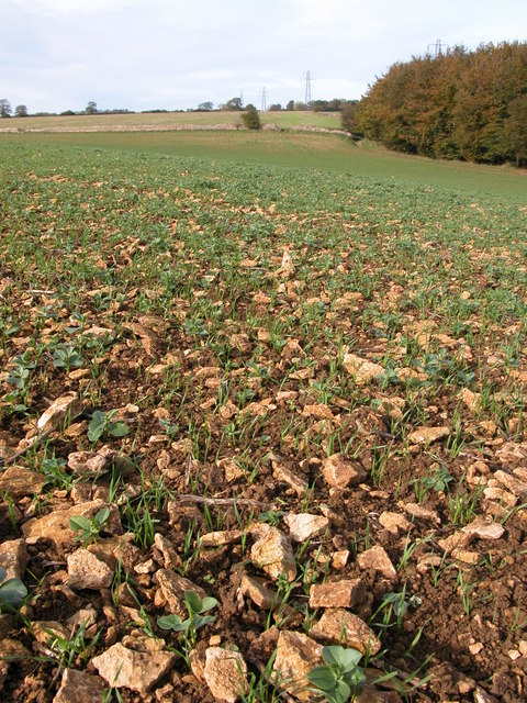
Stony ground near Cranmore Covert Ploughed fields on the Cotswolds can be extremely stony as can be seen here, pieces of oolitic limestone limit the crop. This is a winter cereal crop with broad bean from the previous crop germinating among the cereal.
Stony ground near Cranmore Covert
Ploughed fields on the Cotswolds can be extremely stony as can be seen here, pieces of oolitic limestone limit the crop. This is a winter cereal crop with broad bean from the previous crop germinating among the cereal.
Sheep grazing in a field by Shiptons Grave Lane A footpath crosses diagonally across this field to Shiptons Grave Lane. A salt lick for the sheep can be seen to the right of the electric fence post in the foreground.
Sheep grazing in a field by Shiptons Grave Lane
A footpath crosses diagonally across this field to Shiptons Grave Lane. A salt lick for the sheep can be seen to the right of the electric fence post in the foreground.
Upper Barton End Cotswold stone built houses at Barton End.
Upper Barton End
Cotswold stone built houses at Barton End.
A very large field Adjacent to the A46, from Bath to Gloucester.
A very large field
Adjacent to the A46, from Bath to Gloucester.
Show me another place!

Lagger's Covert is located at Grid Ref: ST8497 (Lat: 51.675003, Lng: -2.2325095)

Administrative County: Gloucestershire

District: Stroud

Police Authority: Gloucestershire

What 3 Words

///record.standard.freely. Near Nailsworth, Gloucestershire

Related Wikis

Horsley Priory

Horsley Priory was a medieval, monastic house in Gloucestershire, England. Goda owned an estate at Horsley, in 1066. It was granted to Troarn Abbey by...

Horsley, Gloucestershire

Horsley is a village and civil parish about one and a half miles south-west of the small Cotswold market town of Nailsworth. The origins of the name Horsley...

Barton End

Barton End is a village just south of Nailsworth, Gloucestershire, England.

Kingscote and Horsley Woods

Kingscote and Horsley Woods (grid reference ST831971) is a 43.79-hectare (108.2-acre) biological Site of Special Scientific Interest in Gloucestershire...

Nearby Amenities

Located within 500m of 51.675003,-2.2325095
Barrier: stile
Lat/Long: 51.6722242/-2.237779
Barrier: stile
Lat/Long: 51.6736365/-2.2353511
Barrier: stile
Lat/Long: 51.6754409/-2.2318835
Barrier: stile
Lat/Long: 51.67719/-2.2324037
Power: pole
Lat/Long: 51.6736144/-2.2337818
Power: pole
Lat/Long: 51.674453/-2.2338751
Power: pole
Lat/Long: 51.6751599/-2.2339985
Power: pole
Lat/Long: 51.6747857/-2.237649
Power: pole
Lat/Long: 51.6745262/-2.2364661
Power: pole
Lat/Long: 51.6742534/-2.2352886
Man Made: tower
Tower Construction: lattice
Lat/Long: 51.673954/-2.235404
Power: pole
Lat/Long: 51.6739499/-2.2339247
Power: pole
Lat/Long: 51.673485/-2.2319439
Power: pole
Lat/Long: 51.673129/-2.2303802
Power: pole
Lat/Long: 51.672482/-2.227993
Power: pole
Lat/Long: 51.6721326/-2.2269952
Barrier: stile
Lat/Long: 51.6783481/-2.2353283
Barrier: stile
Lat/Long: 51.6754621/-2.2382684
Fixme: line possibly incomplete - where does it go next? survey needed
Lat/Long: 51.6758887/-2.2306084
Power: pole
Lat/Long: 51.6755408/-2.2306933
Power: pole
Lat/Long: 51.674912/-2.2302916
Fixme: line possibly incomplete - where does it go next? survey needed
Power: pole
Lat/Long: 51.6735489/-2.2279343
Power: pole
Lat/Long: 51.6739683/-2.229481
Power: pole
Lat/Long: 51.6741307/-2.2305316
Power: pole
Lat/Long: 51.6743629/-2.2319921
Power: pole
Lat/Long: 51.6783109/-2.230069
Power: pole
Lat/Long: 51.6781305/-2.2311983
Power: pole
Lat/Long: 51.6779005/-2.2326339
Power: pole
Lat/Long: 51.6769145/-2.2335766
Power: pole
Lat/Long: 51.6759061/-2.2338185
Power: pole
Lat/Long: 51.6737715/-2.2331536
Power: pole
Lat/Long: 51.6733661/-2.2337778
Power: pole
Lat/Long: 51.6716643/-2.2338368
Barrier: stile
Lat/Long: 51.6772071/-2.2327836
Barrier: stile
Lat/Long: 51.6769906/-2.2327315
The data included in this document is from www.openstreetmap.org. The data is made available under ODbL.

Have you been to Lagger's Covert?

Leave your review of Lagger's Covert below (or comments, questions and feedback).