Five Acre Wood

Wood, Forest in Somerset Mendip

England

Five Acre Wood

2011 : Thrupe Lane heading south Past Rising Sun Cottage.
An overbridge on the old Radstock to Shepton Mallet railway crossed the road at the other end of the straight. The embankment is still there.
2011 : Thrupe Lane heading south Credit: Maurice Pullin

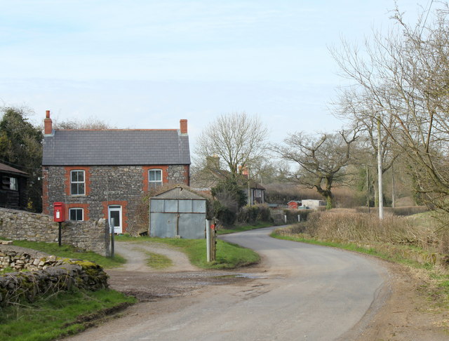
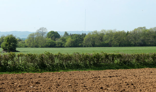
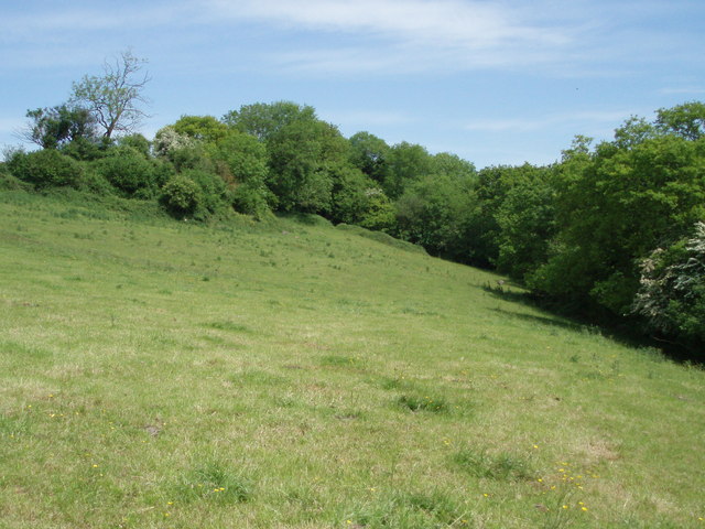
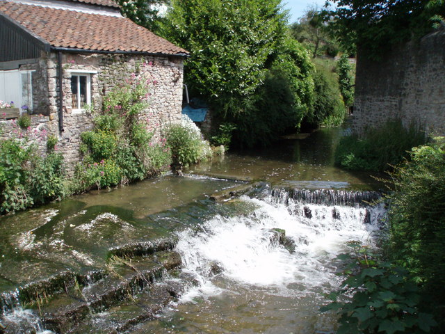
Five Acre Wood, located in Somerset, is a picturesque forest spanning approximately five acres of land. It is a popular destination for nature enthusiasts, hikers, and families seeking a serene and tranquil environment.

The woodland boasts a diverse range of trees, including oak, beech, and birch, which create a dense and lush canopy overhead. The forest floor is carpeted with an assortment of wildflowers, ferns, and mosses, adding to the enchanting atmosphere. Five Acre Wood is also home to a variety of wildlife, such as squirrels, rabbits, and a wide array of bird species.

The forest features well-maintained walking trails that wind through the wood, providing visitors with the opportunity to explore its natural beauty. These paths are suitable for all ages and fitness levels, making it an ideal destination for families with young children or elderly individuals.

A highlight of Five Acre Wood is a small stream that meanders through the forest, creating a peaceful ambiance and offering a spot for visitors to relax and enjoy the soothing sound of running water. There are also several benches strategically placed along the trails, allowing visitors to take in the stunning scenery and rest during their exploration.

The woodland is easily accessible, with ample parking available nearby. It is open year-round, offering visitors the chance to experience the changing seasons and witness the vibrant colors of autumn or the blooming flowers of spring.

Overall, Five Acre Wood is a hidden gem in Somerset, providing a tranquil retreat for nature lovers and a perfect setting for a leisurely walk or a family picnic.

If you have any feedback on the listing, please let us know in the comments section below.

Five Acre Wood Images

Images are sourced within 2km of 51.212594/-2.5903705 or Grid Reference ST5846. Thanks to Geograph Open Source API. All images are credited.

2011 : Thrupe Lane heading south Past Rising Sun Cottage.
An overbridge on the old Radstock to Shepton Mallet railway crossed the road at the other end of the straight. The embankment is still there.
2011 : Thrupe Lane heading south
Past Rising Sun Cottage. An overbridge on the old Radstock to Shepton Mallet railway crossed the road at the other end of the straight. The embankment is still there.
2011 : Thrupe, Somerset In Anglo-Saxon times a thrupe was a dairy farm. (from Wikipedia), not much has changed. <span class="nowrap"><a title="http://www.theoldmilkingparlour.co.uk/contact.html" rel="nofollow ugc noopener" href="http://www.theoldmilkingparlour.co.uk/contact.html">Link</a><img style="margin-left:2px;" alt="External link" title="External link - shift click to open in new window" src="https://s1.geograph.org.uk/img/external.png" width="10" height="10"/></span>
The limestone in this area is riddled with caves and swallets. More in <span class="nowrap"><a title="http://en.wikipedia.org/wiki/Thrupe_Lane_Swallet" rel="nofollow ugc noopener" href="http://en.wikipedia.org/wiki/Thrupe_Lane_Swallet">Link</a><img style="margin-left:2px;" alt="External link" title="External link - shift click to open in new window" src="https://s1.geograph.org.uk/img/external.png" width="10" height="10"/></span> and <span class="nowrap"><a title="http://www.absoluteastronomy.com/topics/Thrupe_Lane_Swallet" rel="nofollow ugc noopener" href="http://www.absoluteastronomy.com/topics/Thrupe_Lane_Swallet">Link</a><img style="margin-left:2px;" alt="External link" title="External link - shift click to open in new window" src="https://s1.geograph.org.uk/img/external.png" width="10" height="10"/></span> among others.
2011 : Thrupe, Somerset
In Anglo-Saxon times a thrupe was a dairy farm. (from Wikipedia), not much has changed. LinkExternal link The limestone in this area is riddled with caves and swallets. More in LinkExternal link and LinkExternal link among others.
2011 : The former Masbury Station On the equally former Somerset & Dorset line between Shepton Mallet and Paulton.
Seen in its glory days, 52 years previously, in <a href="https://www.geograph.org.uk/photo/2180927">ST6047 : Masbury Station, with Up express</a> from almost the same viewpoint.
2011 : The former Masbury Station
On the equally former Somerset & Dorset line between Shepton Mallet and Paulton. Seen in its glory days, 52 years previously, in ST6047 : Masbury Station, with Up express from almost the same viewpoint.
2011 : Thrupe Lane looking north The bank on the right is part of an embankment which carried the Somerset & Dorset Railway, or the Slow and Dirty as it was known locally.
2011 : Thrupe Lane looking north
The bank on the right is part of an embankment which carried the Somerset & Dorset Railway, or the Slow and Dirty as it was known locally.
2011 : Thrupe Main Street Thrupe is so small it only has outskirts, and just one of them.

Easy to sneer but we should remember, Thrupe has its own swallet.
<span class="nowrap"><a title="http://en.wikipedia.org/wiki/Thrupe_Lane_Swallet" rel="nofollow ugc noopener" href="http://en.wikipedia.org/wiki/Thrupe_Lane_Swallet">Link</a><img style="margin-left:2px;" alt="External link" title="External link - shift click to open in new window" src="https://s1.geograph.org.uk/img/external.png" width="10" height="10"/></span>
2011 : Thrupe Main Street
Thrupe is so small it only has outskirts, and just one of them. Easy to sneer but we should remember, Thrupe has its own swallet. LinkExternal link
2011 : Thrupe Lane at Thrupe Heading north near Lower Thrupe Farm.
2011 : Thrupe Lane at Thrupe
Heading north near Lower Thrupe Farm.
2011 : South on Thrupe Lane Passing through Thrupe.
A search of the internet reveals very little about Thrupe.
2011 : South on Thrupe Lane
Passing through Thrupe. A search of the internet reveals very little about Thrupe.
2011 : Plough and pasture north of Ham Lane Looking north of west, Ham Woods is beyond the pasture and beyond that, very faint, the Mendip TV Transmitter on Pen Hill north of Wells <a href="https://www.geograph.org.uk/gridref/ST5648">ST5648</a>
2011 : Plough and pasture north of Ham Lane
Looking north of west, Ham Woods is beyond the pasture and beyond that, very faint, the Mendip TV Transmitter on Pen Hill north of Wells ST5648
Masbury: site/remains of former station, 2001 View southward, towards Evercreech Junction, Templecombe and Bournemouth: ex-Somerset & Dorset Bath - Evercreech Junction - Bournemouth line. The station closed along with the whole line from 7/3/66. (Cf. <a href="https://www.geograph.org.uk/photo/2326538">ST6047 : 2011 : The former Masbury Station</a>).
Masbury: site/remains of former station, 2001
View southward, towards Evercreech Junction, Templecombe and Bournemouth: ex-Somerset & Dorset Bath - Evercreech Junction - Bournemouth line. The station closed along with the whole line from 7/3/66. (Cf. ST6047 : 2011 : The former Masbury Station).
Former Somerset and Dorset Railway Bridge At Maesbury The  former Somerset and Dorset Railway below the bridge is long gone but the Bridge is in fine shape though perhaps a coat of paint.
Former Somerset and Dorset Railway Bridge At Maesbury
The former Somerset and Dorset Railway below the bridge is long gone but the Bridge is in fine shape though perhaps a coat of paint.
Dismantled railway embankment This embankment, now home to horses, was once part of the Somerset and Dorset railway line. The dismantled line continues the north towards Norton-Radstock, and south to Shepton Mallet.  The nearest stop was Maesbury Halt, about a kilometre to the north.
Dismantled railway embankment
This embankment, now home to horses, was once part of the Somerset and Dorset railway line. The dismantled line continues the north towards Norton-Radstock, and south to Shepton Mallet. The nearest stop was Maesbury Halt, about a kilometre to the north.
Field on the north west side of Ham wood
Thrupe Houses and farm in this small Mendip hamlet.
Thrupe
Houses and farm in this small Mendip hamlet.
Fields near East Horrington The near field beside Crapnell Lane has recently been grazed by cattle.
Fields near East Horrington
The near field beside Crapnell Lane has recently been grazed by cattle.
Track near East Horrington This track is the footpath to Thrupemarsh Farm and Burnt House Farm.  It passes between the embankment of the disused railway.
Track near East Horrington
This track is the footpath to Thrupemarsh Farm and Burnt House Farm. It passes between the embankment of the disused railway.
Masbury Station, with Up express View southward, towards Shepton Mallet, Evercreech Junction, Templecombe and Bournemouth West. It is a Summer Saturday, when the difficult Somerset & Dorset line from Bath to Bournemouth was worked to capacity with holiday trains. This is the 11.40 Bournemouth West to Cleethorpes (!) (cf. <a href="https://www.geograph.org.uk/photo/2121992">ST6552 : Down S&D express approaching Chilcompton</a>), here with LMS 4F 0-6-0 piloting Southern Light Pacific No. 34041 'Wilton'. (See other S&D scenes at <a href="https://www.geograph.org.uk/photo/2118341">ST6244 : Northbound Somerset & Dorset train climbing up from Shepton Mallet at Windsor Hill</a>, 
<a href="https://www.geograph.org.uk/photo/2121861">ST6047 : Down S & D train at Masbury Summit</a>, 
<a href="https://www.geograph.org.uk/photo/2121957">ST6144 : Down S&D express near Shepton Mallet</a> and 
<a href="https://www.geograph.org.uk/photo/2122053">ST6653 : Midsomer Norton South Station, with Down express</a>).
Masbury Station, with Up express
View southward, towards Shepton Mallet, Evercreech Junction, Templecombe and Bournemouth West. It is a Summer Saturday, when the difficult Somerset & Dorset line from Bath to Bournemouth was worked to capacity with holiday trains. This is the 11.40 Bournemouth West to Cleethorpes (!) (cf. ST6552 : Down S&D express approaching Chilcompton), here with LMS 4F 0-6-0 piloting Southern Light Pacific No. 34041 'Wilton'. (See other S&D scenes at ST6244 : Northbound Somerset & Dorset train climbing up from Shepton Mallet at Windsor Hill, ST6047 : Down S & D train at Masbury Summit, ST6144 : Down S&D express near Shepton Mallet and ST6653 : Midsomer Norton South Station, with Down express).
Cyclist at the end of Crapnell Lane
Old Direction Sign - Signpost by Crapnell Lane, Croscombe Parish Pyramid finial - 1 arm; Somerset SCC pyramid by the UC road, in parish of Croscombe (Mendip District), at junction of Thrupe Lane with Crapnell Lane, in hedge.

Surveyed

Milestone Society National ID: SO_ST6046.
Old Direction Sign - Signpost by Crapnell Lane, Croscombe Parish
Pyramid finial - 1 arm; Somerset SCC pyramid by the UC road, in parish of Croscombe (Mendip District), at junction of Thrupe Lane with Crapnell Lane, in hedge. Surveyed Milestone Society National ID: SO_ST6046.
Show me another place!

Five Acre Wood is located at Grid Ref: ST5846 (Lat: 51.212594, Lng: -2.5903705)

Administrative County: Somerset

District: Mendip

Police Authority: Avon and Somerset

What 3 Words

///dishing.carpentry.darts. Near Mendip, Somerset

Related Wikis

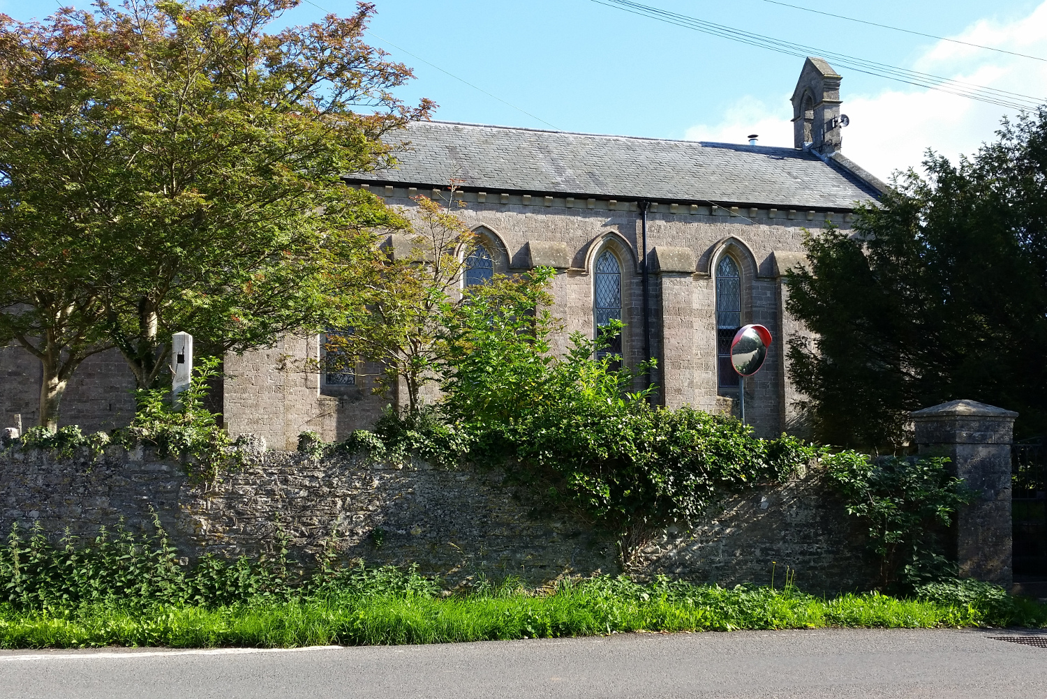
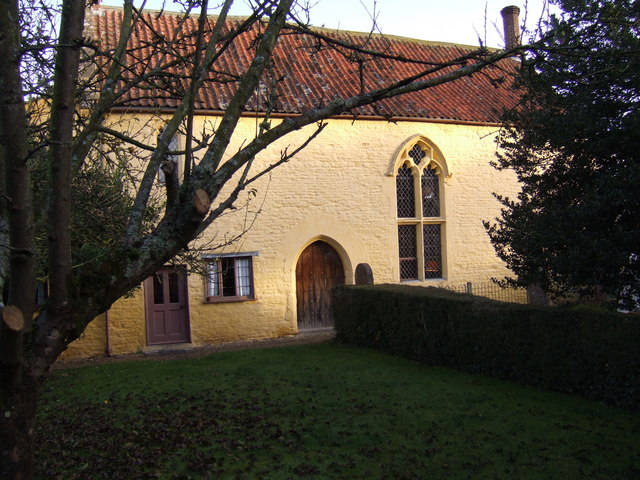
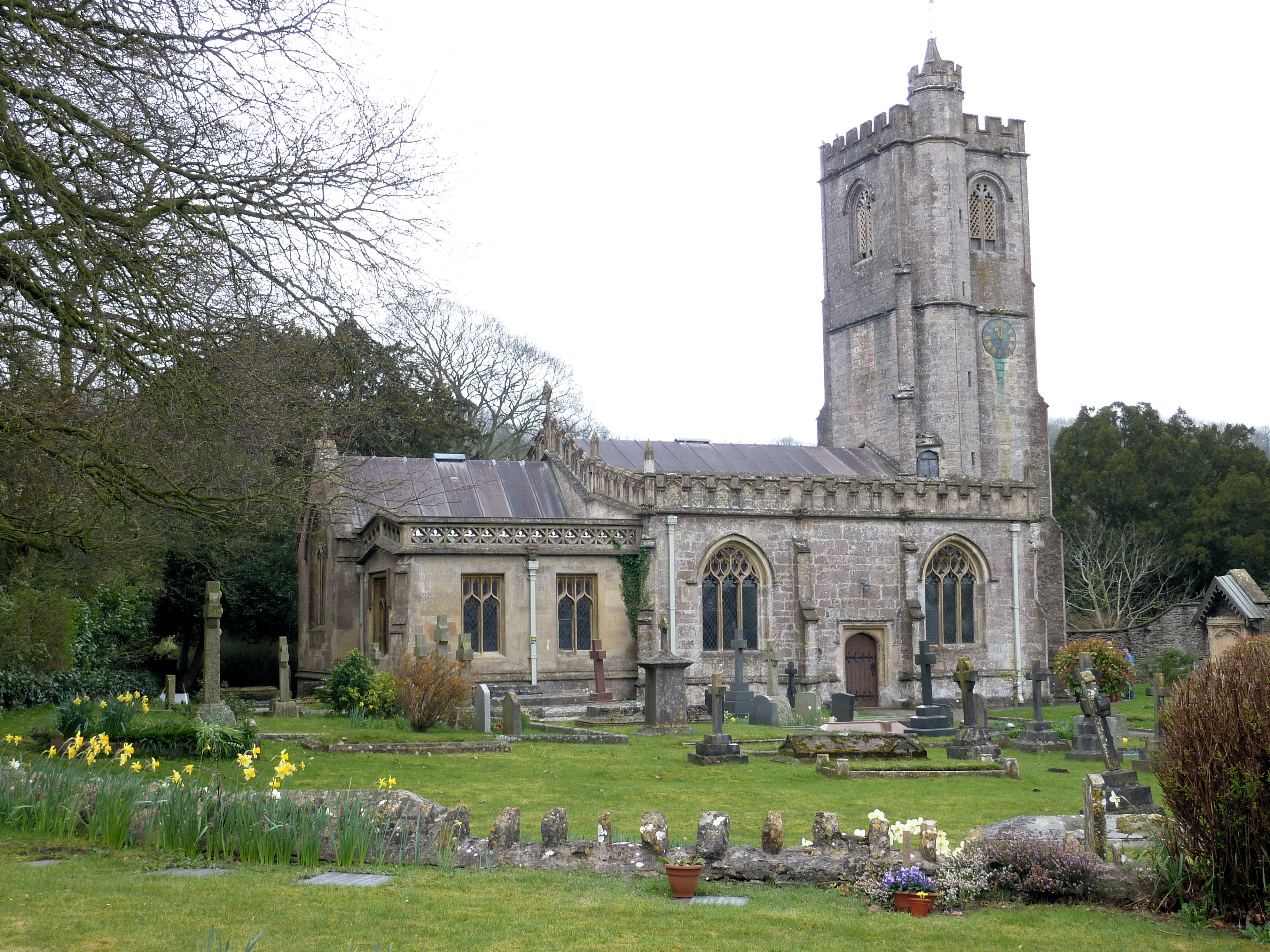
St John's Church, East Horrington

St John's Church is a former Church of England church in East Horrington, Somerset, England. It was built in 1838 to the designs of Richard Carver and...

Horrington

Horrington is a collection of three small villages (South Horrington, East Horrington and West Horrington) in the parish of St Cuthbert Out 1 mile (2 km...

Thrupe Lane Swallet

Thrupe Lane Swallet (grid reference ST603458) is a 0.5 hectares (1.2 acres) geological Site of Special Scientific Interest in Somerset, notified in 1992...

Croscombe

Croscombe is a village and civil parish 2 miles (3 km) west of Shepton Mallet and 4 miles (6 km) from Wells, in the Mendip district of Somerset, England...
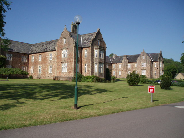
Mendip Hospital

Mendip Hospital opened in 1848 as the Somerset and Bath Pauper Lunatic Asylum at Horrington, near Wells, in the English county of Somerset. As a county...

The Old Rectory, Croscombe

The Old Rectory in the village of Croscombe within the English county of Somerset was built in the 17th century and rebuilt in the 18th. It is a Grade...

The Old Manor, Croscombe

The Old Manor in Croscombe, Somerset, England, was built around 1460–89 as a rectorial manor house for Hugh Sugar, the Treasurer of Wells Cathedral. It...

Dinder

Dinder (which means "the house in the valley") is a small village and former civil parish, now in the parish of St Cuthbert Out, in the Somerset district...

Have you been to Five Acre Wood?

Leave your review of Five Acre Wood below (or comments, questions and feedback).