Colwinston

Settlement in Glamorgan

Wales

Colwinston

Ordnance Survey Cut Mark This OS cut mark can be found on the NE parapet of the Stembridge Brook Bridge. It marks a point 40.654m above mean sea level.
Ordnance Survey Cut Mark Credit: Adrian Dust

Colwinston is a small village located in the Vale of Glamorgan, in South Wales, United Kingdom. Situated approximately 15 miles west of Cardiff, the village falls within the community of Llandow. It is known for its picturesque rural setting and charming countryside views.

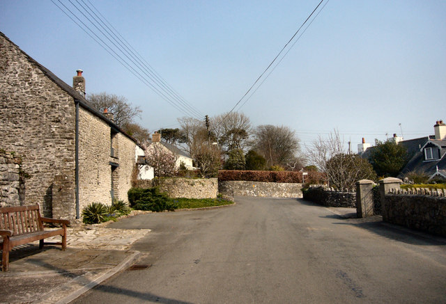
The village of Colwinston has a rich history that dates back to medieval times. It was once a bustling market town, and remnants of this past can still be seen in the form of the historic village square and the 13th-century church of St. Michael and All Angels.

Colwinston is surrounded by lush green fields and rolling hills, making it a popular destination for nature enthusiasts and hikers. The village itself is characterized by traditional stone cottages and well-preserved buildings, adding to its quaint and timeless atmosphere.

Despite its small size, Colwinston offers a range of amenities for its residents and visitors. These include a village hall, a primary school, a local pub, and a post office. The village also hosts various community events throughout the year, such as the Colwinston Flower Show and the annual Christmas fair.

Colwinston's convenient location allows for easy access to nearby towns and cities. The M4 motorway is just a short drive away, providing excellent transport links to Cardiff and other major destinations. Overall, Colwinston offers a peaceful and idyllic setting, making it a desirable place to live or visit for those seeking a slice of rural charm.

If you have any feedback on the listing, please let us know in the comments section below.

Colwinston Images

Images are sourced within 2km of 51.471713/-3.5256674 or Grid Reference SS9475. Thanks to Geograph Open Source API. All images are credited.

Ordnance Survey Cut Mark This OS cut mark can be found on the NE parapet of the Stembridge Brook Bridge. It marks a point 40.654m above mean sea level.
Ordnance Survey Cut Mark
This OS cut mark can be found on the NE parapet of the Stembridge Brook Bridge. It marks a point 40.654m above mean sea level.
Ordnance Survey Rivet This OS rivet can be found on the stile at the entrance to Parcau Farm. It marks a point 38.347m above mean sea level.
Ordnance Survey Rivet
This OS rivet can be found on the stile at the entrance to Parcau Farm. It marks a point 38.347m above mean sea level.
Ordnance Survey Rivet This OS rivet can be found on the wall of No5 Twyn Yr Eglwys. It marks a point 59.747m above mean sea level.
Ordnance Survey Rivet
This OS rivet can be found on the wall of No5 Twyn Yr Eglwys. It marks a point 59.747m above mean sea level.
Ordnance Survey Cut Mark This OS cut mark can be found on the barn conversion at Heol Fawr. It marks a point 75.761m above mean sea level.
Ordnance Survey Cut Mark
This OS cut mark can be found on the barn conversion at Heol Fawr. It marks a point 75.761m above mean sea level.
Ordnance Survey Rivet This OS rivet can be found on the stile NE side of the road. It marks a point 78.946m above mean sea level.
Ordnance Survey Rivet
This OS rivet can be found on the stile NE side of the road. It marks a point 78.946m above mean sea level.
St Michaels and All Angels, Colwinston The roots of this church are Norman with the nave, font and chancel arch dating from this period. The tower probably dates from the sixteenth century and was heightened in the late 17th or early 18th century. The windows largely date from the 16th century as well. There was a Victorian restoration and the church was re-roofed, redecorated and given the north vestry for the millennium.
The church is a grade 1 listed building.
St Michaels and All Angels, Colwinston
The roots of this church are Norman with the nave, font and chancel arch dating from this period. The tower probably dates from the sixteenth century and was heightened in the late 17th or early 18th century. The windows largely date from the 16th century as well. There was a Victorian restoration and the church was re-roofed, redecorated and given the north vestry for the millennium. The church is a grade 1 listed building.
Brocastle Brocastle, the lane from A48 to the residential home
Brocastle
Brocastle, the lane from A48 to the residential home
Brocastle Brocastle, the lane from the residential lane to A48
Brocastle
Brocastle, the lane from the residential lane to A48
A48 A48, view towards Crack Hill
A48
A48, view towards Crack Hill
Corntown Road/Crack Hill junction on A48
A48 looking east
A48 looking east
Pylon next to lane from Treoes
Corntown Farm
Corntown Farm
Corntown Farm
Corntown Farm
New roundabout on the A48, viewed from the B4524
Corntown Rd near the junction with the A48
Junction of Corntown Rd (B4524) with Crack Hill (A48)
The Church of St Michael and All Angels, Colwinston in the 1970s A view of the church from c. 1975. Parts of the church are thought to date from the Norman period. One internet source  (<span class="nowrap"><a title="http://www.coflein.gov.uk/en/site/307572/details/ST+MICHAEL+AND+ALL+ANGELS+CHURCH,+COLWINSTON/" rel="nofollow ugc noopener" href="http://www.coflein.gov.uk/en/site/307572/details/ST+MICHAEL+AND+ALL+ANGELS+CHURCH,+COLWINSTON/">Link</a><img style="margin-left:2px;" alt="External link" title="External link - shift click to open in new window" src="https://s1.geograph.org.uk/img/external.png" width="10" height="10"/></span> ) notes that the font and chancel arch are thought to be 12th century.  Another source (<span class="nowrap"><a title="http://www.valeofglamorgan.gov.uk/files/Living/Planning/Policy/County_Treasures/Colwinston.pdf" rel="nofollow ugc noopener" href="http://www.valeofglamorgan.gov.uk/files/Living/Planning/Policy/County_Treasures/Colwinston.pdf">Link</a><img style="margin-left:2px;" alt="External link" title="External link - shift click to open in new window" src="https://s1.geograph.org.uk/img/external.png" width="10" height="10"/></span> - see also <span class="nowrap"><a title="http://en.wikipedia.org/wiki/Colwinston" rel="nofollow ugc noopener" href="http://en.wikipedia.org/wiki/Colwinston">Link</a><img style="margin-left:2px;" alt="External link" title="External link - shift click to open in new window" src="https://s1.geograph.org.uk/img/external.png" width="10" height="10"/></span> ) notes that the church is reputed to have been originally built in 1111. According to this source, the church was restored in 1879 and suffered damage in a fire in 1971.

 It may be noted that at the time the photograph was taken only some of its exterior walls were rendered and limewashed, whereas more recent pictures of the church reveal that later they all came to be.

The church is a grade I listed building. It was listed in February 1963.
The Church of St Michael and All Angels, Colwinston in the 1970s
A view of the church from c. 1975. Parts of the church are thought to date from the Norman period. One internet source (LinkExternal link ) notes that the font and chancel arch are thought to be 12th century. Another source (LinkExternal link - see also LinkExternal link ) notes that the church is reputed to have been originally built in 1111. According to this source, the church was restored in 1879 and suffered damage in a fire in 1971. It may be noted that at the time the photograph was taken only some of its exterior walls were rendered and limewashed, whereas more recent pictures of the church reveal that later they all came to be. The church is a grade I listed building. It was listed in February 1963.
Show me another place!

Colwinston is located at Grid Ref: SS9475 (Lat: 51.471713, Lng: -3.5256674)

Unitary Authority: The Vale of Glamorgan

Police Authority: South Wales

Also known as: Tregolwyn

What 3 Words

///signature.suggested.handyman. Near Llangan, Vale of Glamorgan

Related Wikis

Colwinston

Colwinston (historically sometimes Colwinstone; Welsh: Tregolwyn) is both a village and a community in the Vale of Glamorgan, Wales, approximately 4 miles...

Llandow (electoral ward)

Llandow (between 1995 and 2022 known as Llandow/Ewenny or Llandow and Ewenny), is the name of an electoral ward in the west of the Vale of Glamorgan, Wales...

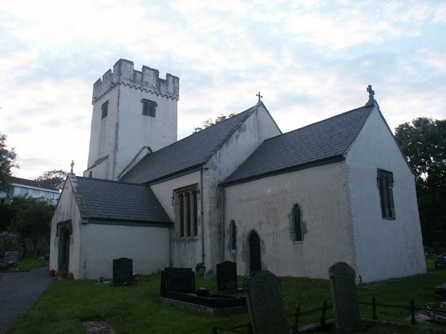
St Michael and All Angels Church, Colwinston

St Michael and All Angels Church is a Grade I listed church in Colwinston, in the Vale of Glamorgan, south Wales. It became a Grade I listed building on...

Llampha

Llampha (also Lampha, Welsh: Llanffa) is a hamlet in the Vale of Glamorgan, South Wales, near Bridgend. It mainly consists of farms and small holdings...

Llandow Halt railway station

Llandow Halt railway station served the village of Llandow in South Wales. == History == When the Vale of Glamorgan Railway opened in 1897, four of its...

Llangan

Llangan (Welsh: Llanganna) is a small village and community in the Vale of Glamorgan, Wales. It is located approximately 4 miles (6.4 km) outside the market...

Llandow

Llandow (Welsh: Llandŵ) is a village and community in the Vale of Glamorgan, Wales. The community population taken at the 2011 census was 726. The village...

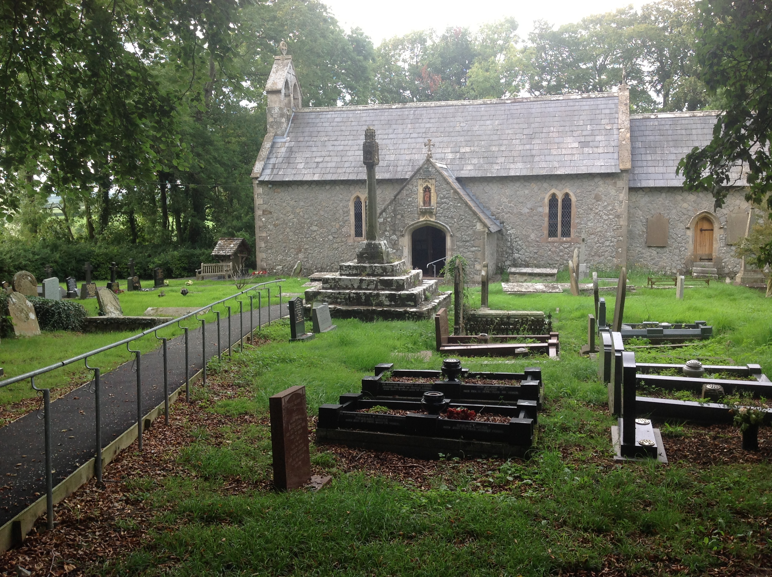
St Canna Church, Llangan

St Canna Church is a church in Llangan, in the Vale of Glamorgan, south Wales. Its churchyard cross is a Grade I listed building, listed on 22 July 2003...

Nearby Amenities

Located within 500m of 51.471713,-3.5256674
Colwinston
Created By: Potlatch 0.10b
Name Cy: Tregolwyn
Place: village
Wikidata: Q3403327
Lat/Long: 51.4686854/-3.5234572
Pub
The Sycamore Tree Inn
Addr City: Colwinston
Addr Postcode: CF71 7NG
Addr Street: Coed Marsarnen
Email: mark@thesycamoretree.co.uk
Fhrs Id: 1072099
Opening Hours: Mo-Tu off; We-Fr 17:00-22:00; Sa 12:00-22:00; Su 12:00-20:00
Phone: +44 1656 652 827
Source Addr: FHRS Open Data
Wikidata: Q80584866
Lat/Long: 51.4677196/-3.5266663
Place Of Worship
St. Michael and All Angels
Denomination: anglican
Name Cy: Eglwys Sant Mihangel a'r Holl Angylion
Religion: christian
Wikidata: Q17743800
Lat/Long: 51.4675654/-3.5279558
Colwinston Community Centre
Created By: Potlatch 0.10b
Leisure: sports_centre
Lat/Long: 51.4708722/-3.5266587
Cafe
Charlie's Cafe
Addr City: Colwinston
Addr Postcode: CF71 7NL
Fhrs Id: 1012558
Source Addr Postcode: FHRS Open Data
Lat/Long: 51.4728107/-3.5263305
Post Box
Collection Times: Mo-Fr 15:15; Sa 10:00
Operator: Royal Mail
Post Box Mounting: stone_wall
Post Box Type: wall
Ref: CF71 355
Royal Cypher: EIIR
Royal Cypher Wikidata: Q33102113
Lat/Long: 51.4679814/-3.5250221
Direction: SSE
Generator Method: photovoltaic
Generator Output Electricity: yes
Generator Solar Modules: 16
Generator Source: solar
Generator Type: solar_photovoltaic_panel
Location: roof
Power: generator
Lat/Long: 51.4673995/-3.5264209
Direction: SSE
Generator Method: photovoltaic
Generator Output Electricity: yes
Generator Solar Modules: 16
Generator Source: solar
Generator Type: solar_photovoltaic_panel
Location: roof
Power: generator
Lat/Long: 51.471274/-3.5245779
Direction: S
Generator Method: photovoltaic
Generator Output Electricity: yes
Generator Solar Modules: 12
Generator Source: solar
Generator Type: solar_photovoltaic_panel
Location: roof
Power: generator
Lat/Long: 51.4691404/-3.5254295
The data included in this document is from www.openstreetmap.org. The data is made available under ODbL.

Have you been to Colwinston?

Leave your review of Colwinston below (or comments, questions and feedback).