Cunswick Wood

Wood, Forest in Westmorland South Lakeland

England

Cunswick Wood

Footpath from Scout Scar to Underbarrow Road
Footpath from Scout Scar to Underbarrow Road Credit: Roger Templeman

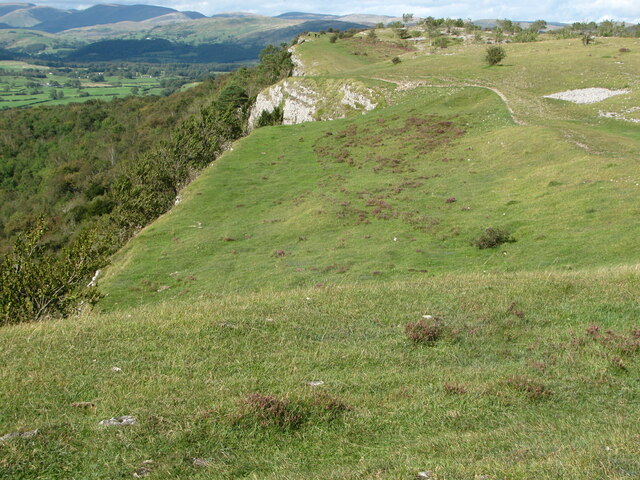
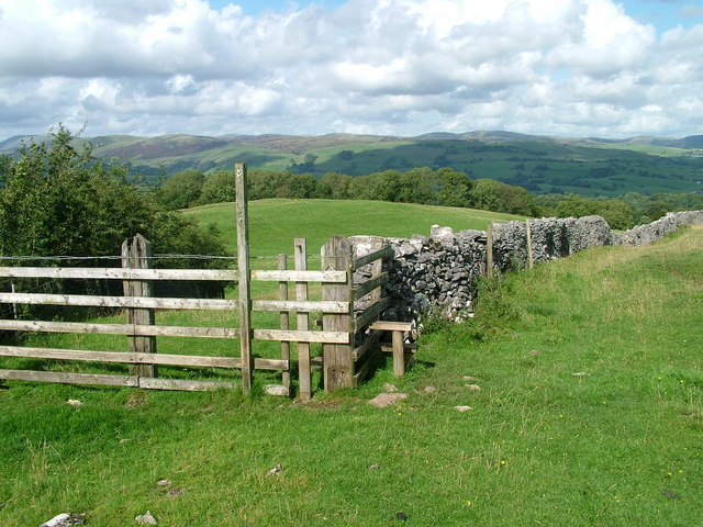
Cunswick Wood is a picturesque forest located in Westmorland, England. Situated near the village of Natland, the wood covers an area of approximately 90 acres. This ancient woodland is a nature lover's paradise, offering a tranquil escape from the hustle and bustle of everyday life.

The woodland is predominantly made up of native broad-leaved trees such as oak, birch, and beech, which provide a rich habitat for various species of flora and fauna. Bluebells carpet the forest floor in spring, creating a stunning display of vibrant colors. The wood is also home to a diverse range of bird species, including woodpeckers, owls, and warblers, making it a popular spot for birdwatchers.

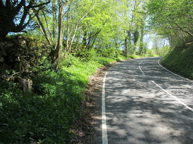
Cunswick Wood is crisscrossed with a network of well-maintained footpaths, allowing visitors to explore its beauty at their own pace. The wood offers a range of walking routes, from short strolls to longer hikes, catering to all abilities. Along the way, visitors can enjoy breathtaking views of the surrounding countryside, including the nearby rolling hills and the distant Lake District.

In addition to its natural beauty, Cunswick Wood is steeped in history. The wood is known to have been used by the local community for centuries, providing a source of timber and firewood. Today, it is managed by the Woodland Trust, ensuring its preservation for future generations to enjoy.

Cunswick Wood is a true gem of Westmorland, offering a peaceful retreat for nature enthusiasts and a glimpse into the region's rich natural and cultural heritage.

If you have any feedback on the listing, please let us know in the comments section below.

Cunswick Wood Images

Images are sourced within 2km of 54.327741/-2.7870515 or Grid Reference SD4892. Thanks to Geograph Open Source API. All images are credited.

Footpath from Scout Scar to Underbarrow Road
The view from Scout Scar A short way from Kendal town brings these fine views over the National Park.
The view from Scout Scar
A short way from Kendal town brings these fine views over the National Park.
Rivet benchmark on milestone in Underbarrow Road Ordnance Survey rivet benchmark on the top of an old milestone that once read 'Kendal 2'. The mark was levelled at 171.225m above Newlyn Datum, verified 1971. For a wider view see <a href="https://www.geograph.org.uk/photo/7456528">SD4892 : Underbarrow Road and a 'Kendal' milestone</a> and  <a href="https://www.geograph.org.uk/photo/2819112">SD4892 : Mile stone, Underbarrow Road</a>  <span class="nowrap"><a title="https://www.bench-marks.org.uk/bm190192" rel="nofollow ugc noopener" href="https://www.bench-marks.org.uk/bm190192">Link</a><img style="margin-left:2px;" alt="External link" title="External link - shift click to open in new window" src="https://s1.geograph.org.uk/img/external.png" width="10" height="10"/></span>
Rivet benchmark on milestone in Underbarrow Road
Ordnance Survey rivet benchmark on the top of an old milestone that once read 'Kendal 2'. The mark was levelled at 171.225m above Newlyn Datum, verified 1971. For a wider view see SD4892 : Underbarrow Road and a 'Kendal' milestone and SD4892 : Mile stone, Underbarrow Road LinkExternal link
Underbarrow Road and a 'Kendal' milestone Looking towards Kendal on Underbarrow Road, and on the left there is an old milestone that once read 'Kendal 2'. On top of the milestone there is an Ordnance Survey rivet benchmark <a href="https://www.geograph.org.uk/photo/7456523">SD4892 : Rivet benchmark on milestone in Underbarrow Road</a>

Milestone Society National ID: WE_KDCE02
Underbarrow Road and a 'Kendal' milestone
Looking towards Kendal on Underbarrow Road, and on the left there is an old milestone that once read 'Kendal 2'. On top of the milestone there is an Ordnance Survey rivet benchmark SD4892 : Rivet benchmark on milestone in Underbarrow Road Milestone Society National ID: WE_KDCE02
Trig point of Scout Scar, 229m
Gateway to Gamblesmire Lane from Underbarrow Road
Benchmark on Barrowfield triangulation pillar Ordnance Survey flush bracket (serial identifier S5672) levelled at 229.454m above Newlyn Datum in 1953
Benchmark on Barrowfield triangulation pillar
Ordnance Survey flush bracket (serial identifier S5672) levelled at 229.454m above Newlyn Datum in 1953
Barrowfield trig point above Scout Scar There is an Ordnance Survey benchmark <a href="https://www.geograph.org.uk/photo/7660251">SD4891 : Benchmark on Barrowfield triangulation pillar</a> set into the face of the pillar towards the camera. The pillar is described at <span class="nowrap"><a title="https://trigpointing.uk/trig/1062" rel="nofollow ugc noopener" href="https://trigpointing.uk/trig/1062">Link</a><img style="margin-left:2px;" alt="External link" title="External link - shift click to open in new window" src="https://s1.geograph.org.uk/img/external.png" width="10" height="10"/></span>
Barrowfield trig point above Scout Scar
There is an Ordnance Survey benchmark SD4891 : Benchmark on Barrowfield triangulation pillar set into the face of the pillar towards the camera. The pillar is described at LinkExternal link
Footpath Sign Brigsteer Road Footpath goes over Bradleyfield and Helsington Barrows
Footpath Sign Brigsteer Road
Footpath goes over Bradleyfield and Helsington Barrows
Stile and Milestone On the Brigsteer Road. Milestone is 1 mile from Kendal
Stile and Milestone
On the Brigsteer Road. Milestone is 1 mile from Kendal
Beech Brigsteer Road Brigsteer Road climbs out of Kendal towards Helsington Barrows
Beech Brigsteer Road
Brigsteer Road climbs out of Kendal towards Helsington Barrows
Leaving Kendal There is some great stonework in Kendal
Leaving Kendal
There is some great stonework in Kendal
Kendal Fell From the road to Burneside
Kendal Fell
From the road to Burneside
Golf Course above Kendal Course on Kendal Fell
Golf Course above Kendal
Course on Kendal Fell
Gateway to . . . . This gateway can be seen over the wall by where walkers park their cars.
Gateway to . . . .
This gateway can be seen over the wall by where walkers park their cars.
Brackenwood, Kendal A modern housing development off Brigsteer Road.
Brackenwood, Kendal
A modern housing development off Brigsteer Road.
A591 west of Kendal The A591 by-passes Kendal to the west providing a fast route into the Lake District for traffic off the M6. It is seen here from the Brigsteer Road bridge on a cold morning.
A591 west of Kendal
The A591 by-passes Kendal to the west providing a fast route into the Lake District for traffic off the M6. It is seen here from the Brigsteer Road bridge on a cold morning.
Sheep Pasture Near Bradleyfield Looking towards the bridge over the Kendal by-pass (<a href="https://www.geograph.org.uk/gridref/SD4992">SD4992</a>).
Sheep Pasture Near Bradleyfield
Looking towards the bridge over the Kendal by-pass (SD4992).
Show me another place!

Cunswick Wood is located at Grid Ref: SD4892 (Lat: 54.327741, Lng: -2.7870515)

Administrative County: Cumbria

District: South Lakeland

Police Authority: Cumbria

What 3 Words

///market.daisy.delay. Near Kendal, Cumbria

Related Wikis

Scout Scar

Scout Scar, also called Underbarrow Scar, is a hill in the English Lake District, west of Kendal, Cumbria and above the village of Underbarrow. It reaches...
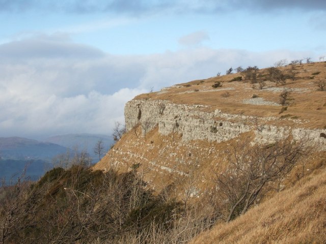
Cunswick Scar

Cunswick Scar is a limestone scar (cliff or steep rock face) in the Lake District, England. There are extensive views from the large cairn at the top...

Helsfell Hall

Helsfell Hall was a country house near Kentrigg in Cumbria. That part of the building which survives, and is now used as a barn, is a Grade II listed building...

Smooth Lake District

Smooth Lake District is an Independent Local Radio station for the Lakes, owned and operated by Global and part of the Smooth network. == Overview == Originally...

Underbarrow

Underbarrow is a small village in Cumbria, England, located 3 miles (4.8 km) west of Kendal. The village is in the Lake District National Park. It is in...

Castle Howe

Castle Howe is a motte and bailey castle in the town of Kendal, England. == History == Castle Howe was built after the Norman conquest of England, either...

St Thomas' Church, Kendal

St Thomas' Church is in Stricklandgate, Kendal, Cumbria, England. It is an active Anglican parish church in the deanery of Kendal, the archdeaconry of...

Strickland Ketel

Strickland Ketel (sometimes Strickland Kettle) is a civil parish in South Lakeland, Cumbria, England. In the 2001 census the parish had a population of...

Nearby Amenities

Located within 500m of 54.327741,-2.7870515
Barrier: kissing_gate
Lat/Long: 54.3259773/-2.7872417
Bradleyfield Radio Mast
Man Made: tower
Note: Name is associated with triangulation point. May not be official ref
Tower Construction: lattice
Tower Type: communication
Lat/Long: 54.325106/-2.7869197
Barrier: kissing_gate
Lat/Long: 54.3305861/-2.79167
Barrier: kissing_gate
Lat/Long: 54.3244257/-2.7885693
Bench
Lat/Long: 54.3243288/-2.789659
Bench
Lat/Long: 54.3241515/-2.7908803
Bench
Lat/Long: 54.3245398/-2.7901574
Hiking: yes
Information: guidepost
Tourism: information
Lat/Long: 54.3244215/-2.7885402
Note: There is a donation box, but no vending machine (Sep 2023)
Razed Amenity: vending_machine
Vending: parking_tickets
Lat/Long: 54.3244977/-2.7877646
Barrier: swing_gate
Foot: yes
Lat/Long: 54.3249853/-2.7863002
Hiking: yes
Information: guidepost
Tourism: information
Lat/Long: 54.3260158/-2.7872416
Material: wood
Power: pole
Lat/Long: 54.326374/-2.7857798
Material: wood
Power: pole
Lat/Long: 54.3268574/-2.7845138
Hiking: yes
Information: guidepost
Tourism: information
Lat/Long: 54.3277833/-2.7820254
Power: pole
Lat/Long: 54.3259489/-2.7869968
Power: pole
Lat/Long: 54.3273707/-2.7832639
Power: pole
Lat/Long: 54.3278845/-2.7819947
Power: pole
Lat/Long: 54.3280076/-2.7805762
The data included in this document is from www.openstreetmap.org. The data is made available under ODbL.

Have you been to Cunswick Wood?

Leave your review of Cunswick Wood below (or comments, questions and feedback).