West Knowles Wood

Wood, Forest in Shropshire

England

West Knowles Wood

Winter cereals, Whettleton
Winter cereals, Whettleton Credit: Richard Webb

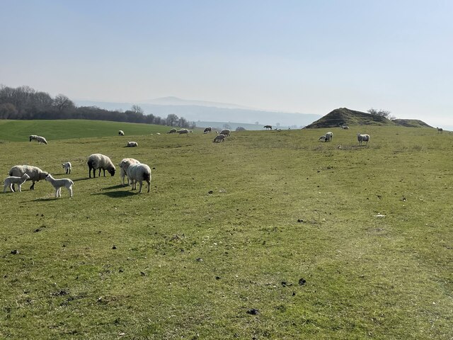
West Knowles Wood is a picturesque woodland located in the county of Shropshire, England. Situated in close proximity to the village of Knowles Wood, this forested area spans over an expansive 200 acres. The wood can be accessed via a network of well-maintained footpaths, allowing visitors to explore the beauty of the natural surroundings.

The woodland is predominantly composed of native broadleaf trees, including oak, birch, and beech. These tall and majestic trees form a dense canopy, providing shelter to an array of wildlife species. Among the wildlife that can be spotted in West Knowles Wood are deer, foxes, badgers, and an abundance of bird species.

The forest floor is adorned with a rich carpet of wildflowers, creating a vibrant and colorful display during the spring and summer months. This attracts numerous insects, butterflies, and bees, contributing to the overall biodiversity of the area.

West Knowles Wood is a popular destination for nature enthusiasts, walkers, and photographers. The tranquil atmosphere and stunning natural vistas make it an ideal spot for a leisurely stroll or a peaceful picnic. The wood offers a sense of serenity and escape from the hustle and bustle of everyday life.

Managed by a local conservation organization, West Knowles Wood is dedicated to preserving the natural habitat and promoting sustainable practices. Visitors are encouraged to respect the environment and adhere to the designated trails to minimize any disruption to the ecosystem.

In conclusion, West Knowles Wood in Shropshire is a delightful woodland retreat, offering a haven of tranquility and a chance to connect with nature in a truly breathtaking setting.

If you have any feedback on the listing, please let us know in the comments section below.

West Knowles Wood Images

Images are sourced within 2km of 52.442895/-2.8078867 or Grid Reference SO4583. Thanks to Geograph Open Source API. All images are credited.

Winter cereals, Whettleton
B4368, Whettleton Just east of Craven Arms.
B4368, Whettleton
Just east of Craven Arms.
Greenway Cross
Greenway Cross
Under Norton Camp Whettleton Woods and arable farmland.
Under Norton Camp
Whettleton Woods and arable farmland.
Almost Irish Signpost at Greenway Cross.  The National Cycle Network route is still shown after the network was severely degraded earlier in the year.
Almost Irish
Signpost at Greenway Cross. The National Cycle Network route is still shown after the network was severely degraded earlier in the year.
B4368, near Greenway Cross Craven Arms to Corve Dale road.
B4368, near Greenway Cross
Craven Arms to Corve Dale road.
Winter cereals, Whettleton Above Greenway Cross.
Winter cereals, Whettleton
Above Greenway Cross.
Road through Norton Norton is a common placename, but few of them have grown to any size.
Road through Norton
Norton is a common placename, but few of them have grown to any size.
River Onny from the White Bridge in Craven Arms Plenty of water still flowing under the bridge on a lovely Spring day.
River Onny from the White Bridge in Craven Arms
Plenty of water still flowing under the bridge on a lovely Spring day.
The White Bridge over the River Onny in Craven Arms Lovely old, unique and distinctive footbridge.
The White Bridge over the River Onny in Craven Arms
Lovely old, unique and distinctive footbridge.
Rocky outcrops on Halford Hill, north east of Craven Arms Peaceful and contented sheep on the hillside.
Rocky outcrops on Halford Hill, north east of Craven Arms
Peaceful and contented sheep on the hillside.
Lower Dinchope residence The building on the right is the old chapel, with a date plate of 1862 and an original stained glass window.
Lower Dinchope residence
The building on the right is the old chapel, with a date plate of 1862 and an original stained glass window.
Field of young rape seed north of Bache Believe it or not a public footpath lies through this field, unmarked by the farmer. In a month this will be inpassable unless the farmer intervenes.
Field of young rape seed north of Bache
Believe it or not a public footpath lies through this field, unmarked by the farmer. In a month this will be inpassable unless the farmer intervenes.
Bache Farm Magnificent farm house and attached buildings in this idyllic setting
Bache Farm
Magnificent farm house and attached buildings in this idyllic setting
Farm buildings at Norton Restored old long barn by the looks of it.
Farm buildings at Norton
Restored old long barn by the looks of it.
Grand old building in Norton Interesting extended buildings, very well manicured and now being used as apartments of some kind. Beautiful setting
Grand old building in Norton
Interesting extended buildings, very well manicured and now being used as apartments of some kind. Beautiful setting
Field of young wheat near Norton Another footpath crossing a planted field. Hopefully the farmer will delineate the footpath before the crop is fully grown.
Field of young wheat near Norton
Another footpath crossing a planted field. Hopefully the farmer will delineate the footpath before the crop is fully grown.
Show me another place!

West Knowles Wood is located at Grid Ref: SO4583 (Lat: 52.442895, Lng: -2.8078867)

Unitary Authority: Shropshire

Police Authority: West Mercia

What 3 Words

///cattle.smug.viewer. Near Craven Arms, Shropshire

Related Wikis

Halford, Shropshire

Halford is a hamlet and former civil parish, now in the parish of Craven Arms, in the Shropshire district, in south Shropshire, England. It lies just east...

Land of Lost Content (museum)

The Land of Lost Content is a museum in Craven Arms, Shropshire, that collects everyday objects such as toys, magazines and packaging.The museum's name...

Shropshire Hills Discovery Centre

Shropshire Hills Discovery Centre is a museum in southern Shropshire, just south of Craven Arms. == The Shropshire Hills Discovery Centre == The museum...

Craven Arms

Craven Arms is a market town and civil parish in Shropshire, England, on the A49 road and the Welsh Marches railway line, which link it north and south...

Nearby Amenities

Located within 500m of 52.442895,-2.8078867
Power: pole
Lat/Long: 52.438787/-2.8085142
Power: pole
Lat/Long: 52.4391892/-2.8097963
Power: pole
Lat/Long: 52.439665/-2.8113252
Power: pole
Lat/Long: 52.440149/-2.812905
Power: pole
Lat/Long: 52.4408881/-2.8013662
Power: pole
Lat/Long: 52.4405709/-2.8027394
Power: pole
Lat/Long: 52.4408128/-2.804153
Power: pole
Lat/Long: 52.4410287/-2.805427
Power: pole
Lat/Long: 52.4412625/-2.8068754
Power: pole
Lat/Long: 52.4415094/-2.8082621
Power: pole
Lat/Long: 52.4417644/-2.8097481
Power: pole
Lat/Long: 52.442044/-2.8112501
Power: pole
Lat/Long: 52.4422353/-2.8125644
Power: pole
Lat/Long: 52.4424593/-2.8138626
Power: pole
Lat/Long: 52.4426359/-2.8150347
Generator Method: photovoltaic
Generator Output Electricity: yes
Generator Source: solar
Generator Type: solar_photovoltaic_panel
Location: roof
Power: generator
Lat/Long: 52.4421094/-2.8138894
The data included in this document is from www.openstreetmap.org. The data is made available under ODbL.

Have you been to West Knowles Wood?

Leave your review of West Knowles Wood below (or comments, questions and feedback).