Cold Harbour

Settlement in Oxfordshire South Oxfordshire

England

Cold Harbour

K6 telephone box and bus shelter, Cray's Pond
K6 telephone box and bus shelter, Cray's Pond Credit: JThomas

Cold Harbour is a small village located in the county of Oxfordshire, England. Situated in the Cherwell Valley, it is nestled between the larger towns of Bicester and Banbury. The village is primarily residential, with a population of around 500 people.

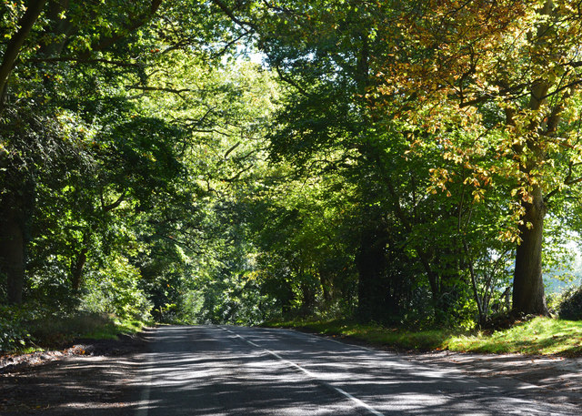
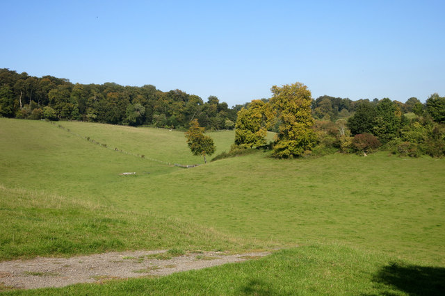
Cold Harbour is renowned for its picturesque countryside, with rolling green hills and charming rural landscapes. The village is surrounded by farmland, creating a tranquil and idyllic atmosphere. It is a popular destination for nature lovers and outdoor enthusiasts, offering numerous walking and cycling routes that showcase the area's natural beauty.

Despite its small size, Cold Harbour has a strong sense of community. The village has a vibrant social scene, with regular events and gatherings organized by local residents. These range from traditional festivals and fairs to community sports tournaments and charity fundraisers.

The village also benefits from its proximity to larger towns and cities. Bicester, a mere 5 miles away, provides residents with convenient access to a wide range of amenities, including shopping centers, restaurants, and schools. The nearby M40 motorway ensures easy connectivity to London and Birmingham, making Cold Harbour an attractive location for commuters.

In summary, Cold Harbour offers a peaceful and picturesque setting, ideal for those seeking a rural lifestyle without sacrificing the convenience of nearby urban centers. With its strong community spirit and beautiful surroundings, it remains a desirable place to call home in Oxfordshire.

If you have any feedback on the listing, please let us know in the comments section below.

Cold Harbour Images

Images are sourced within 2km of 51.515264/-1.091618 or Grid Reference SU6379. Thanks to Geograph Open Source API. All images are credited.

K6 telephone box and bus shelter, Cray's Pond
Bus shelter on the B4526, Cray's Pond
B4526, Cray's Pond
B4526, Cray's Pond
The White Lion, Cray's Pond Not currently open (2022).
See <a href="https://www.geograph.org.uk/photo/2829589">SU6380 : The White Lion, Crays Pond</a> for happier times.
The White Lion, Cray's Pond
Not currently open (2022). See SU6380 : The White Lion, Crays Pond for happier times.
Garage and car sales, Cray's Pond
Gated track and footpath off Goring Road
Goring Road The B471 towards Woodcote.
Goring Road
The B471 towards Woodcote.
House on Goring Road
Roadworks on Goring Road (B471)
George VI postbox on Goring Road, Woodcote Postbox No. RG8 356.
George VI postbox on Goring Road, Woodcote
Postbox No. RG8 356.
Grazing off the B471
B471 heading north Towards Woodcote.
B471 heading north
Towards Woodcote.
 St John the Baptist Church, Whitchurch Hill
St John the Baptist Church, Whitchurch Hill
Grazing and woodland, Whitchurch Hill
B471, Whitchurch Hill Heading north towards Woodcote.
B471, Whitchurch Hill
Heading north towards Woodcote.
Elizabeth II postbox, Whitchurch Hill Postbox No. RG8 216.
Elizabeth II postbox, Whitchurch Hill
Postbox No. RG8 216.
Country road, Crays Pond, Oxfordshire
Towards Merricroft's Wood Seen from the Thames Path, which despite being on one of the most up and down sections of its whole route, is quite short on views along this bit due to being mainly in the woods..
Towards Merricroft's Wood
Seen from the Thames Path, which despite being on one of the most up and down sections of its whole route, is quite short on views along this bit due to being mainly in the woods..
Show me another place!

Cold Harbour is located at Grid Ref: SU6379 (Lat: 51.515264, Lng: -1.091618)

Administrative County: Oxfordshire

District: South Oxfordshire

Police Authority: Thames Valley

What 3 Words

///rebounder.pulses.opts. Near Goring, Oxfordshire

Related Wikis

Goring Rural District

Goring was a rural district in Oxfordshire, England from 1894 to 1932. It was formed from that part of the Bradfield rural sanitary district which was...

Goring Heath

Goring Heath is a hamlet and civil parish in the Chiltern Hills in South Oxfordshire. The civil parish includes the villages of Whitchurch Hill and Crays...

Crays Pond

Crays Pond is a hamlet situated in the parish of Goring Heath in South Oxfordshire. Crays Pond is about 2.4 miles (3.9 km) northeast of Goring-on-Thames...

The Oratory Preparatory School

The Oratory Prep School is a Roman Catholic day and boarding school for some 330 boys and girls aged from two to thirteen, founded in 1925. The school...

Nearby Amenities

Located within 500m of 51.515264,-1.091618
Created By: Merkaartor 0.13
Lat/Long: 51.5169954/-1.0856079
Created By: Merkaartor 0.13
Lat/Long: 51.516931/-1.0875177
Created By: Merkaartor 0.13
Lat/Long: 51.5177679/-1.0887837
Created By: Merkaartor 0.13
Lat/Long: 51.5180367/-1.0892343
Created By: Merkaartor 0.13
Lat/Long: 51.5141505/-1.0897664
Created By: Merkaartor 0.13
Lat/Long: 51.5140771/-1.0890626
Created By: Merkaartor 0.13
Lat/Long: 51.5139484/-1.0901999
Created By: Merkaartor 0.13
Lat/Long: 51.5137767/-1.0906719
Created By: Merkaartor 0.13
Lat/Long: 51.5136909/-1.0914015
Created By: Merkaartor 0.13
Lat/Long: 51.5124893/-1.094191
Created By: Merkaartor 0.13
Lat/Long: 51.512566/-1.0941654
Created By: Merkaartor 0.13
Lat/Long: 51.5126824/-1.0941266
Created By: Merkaartor 0.13
Lat/Long: 51.5129828/-1.093955
Created By: Merkaartor 0.13
Lat/Long: 51.514635/-1.0939764
Created By: Merkaartor 0.13
Lat/Long: 51.5138626/-1.092275
Created By: Merkaartor 0.13
Lat/Long: 51.5142059/-1.0933112
Created By: Merkaartor 0.13
Lat/Long: 51.5144205/-1.0936545
Created By: Merkaartor 0.13
Lat/Long: 51.5145277/-1.0937404
Created By: Merkaartor 0.13
Lat/Long: 51.5139698/-1.0881185
Created By: Merkaartor 0.13
Lat/Long: 51.5139484/-1.0871958
Created By: Merkaartor 0.13
Lat/Long: 51.5140557/-1.0863589
Created By: Merkaartor 0.13
Lat/Long: 51.5183043/-1.0910367
Created By: Merkaartor 0.13
Lat/Long: 51.5180518/-1.0928605
Created By: Merkaartor 0.13
Lat/Long: 51.5176176/-1.0940193
Created By: Merkaartor 0.13
Lat/Long: 51.5174245/-1.0955643
Created By: Merkaartor 0.13
Lat/Long: 51.5153646/-1.0982894
Created By: Merkaartor 0.13
Lat/Long: 51.5154504/-1.0977315
Created By: Merkaartor 0.13
Lat/Long: 51.5156864/-1.0968947
Barrier: kissing_gate
Foot: yes
Lat/Long: 51.5158971/-1.0888471
Barrier: kissing_gate
Foot: yes
Lat/Long: 51.516186/-1.0880545
Barrier: kissing_gate
Foot: yes
Lat/Long: 51.5166396/-1.0868099
Entrance: main
Lat/Long: 51.514478/-1.0849316
Barrier: kissing_gate
Bicycle: no
Foot: yes
Lat/Long: 51.5136743/-1.0909031
Barrier: kissing_gate
Bicycle: no
Foot: yes
Lat/Long: 51.5113225/-1.0889996
Barrier: kissing_gate
Bicycle: no
Foot: yes
Lat/Long: 51.5126214/-1.0940129
Power: pole
Lat/Long: 51.5162508/-1.0849375
Power: pole
Lat/Long: 51.51574/-1.0856187
Power: pole
Lat/Long: 51.5149488/-1.0862893
Power: pole
Lat/Long: 51.5140608/-1.0869598
Power: pole
Lat/Long: 51.5132145/-1.0868606
The data included in this document is from www.openstreetmap.org. The data is made available under ODbL.

Have you been to Cold Harbour?

Leave your review of Cold Harbour below (or comments, questions and feedback).