Appleby

Settlement in Lincolnshire

England

Appleby

School Lane, Appleby
School Lane, Appleby Credit: David Brown

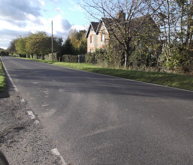
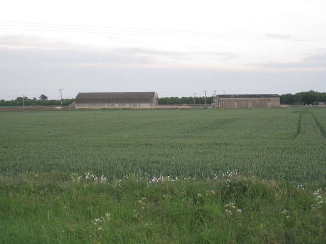
Appleby is a small village located in the county of Lincolnshire, England. Situated approximately 5 miles north of Scunthorpe, Appleby is nestled in a rural setting with picturesque countryside views. The village is surrounded by agricultural land, with rich farmland dominating the landscape.

Appleby is home to a close-knit community, with a population of around 500 residents. The village boasts a quaint charm, with traditional stone cottages and well-maintained gardens lining its streets. Despite its small size, Appleby offers a range of amenities, including a village hall, a primary school, and a local pub that serves as a popular gathering spot for locals.

The village is well-connected to nearby towns and cities, with regular bus services operating to Scunthorpe and other neighboring areas. The proximity to larger urban areas allows residents of Appleby to access a wider range of services and employment opportunities.

Appleby is also known for its natural beauty, with the River Trent running along its western boundary. This provides opportunities for leisurely walks and fishing. Additionally, the surrounding countryside offers ample green spaces for outdoor activities such as hiking and cycling.

In summary, Appleby is a charming village in Lincolnshire that offers a peaceful countryside lifestyle while still providing convenient access to nearby towns. With its close-knit community and picturesque surroundings, Appleby is an ideal place for those seeking a tranquil and idyllic setting.

If you have any feedback on the listing, please let us know in the comments section below.

Appleby Images

Images are sourced within 2km of 53.623139/-0.561626 or Grid Reference SE9515. Thanks to Geograph Open Source API. All images are credited.

School Lane, Appleby
St Bartholomew's Church, Appleby
B1207 in Appleby
B1207 in Appleby
Low Risby Farm
Low Risby Farm
Disused pumping station near Scotney Farm Even out here the vandals have struck.
Disused pumping station near Scotney Farm
Even out here the vandals have struck.
Mickleholme Farm Farm buildings but no farmhouse.
Mickleholme Farm
Farm buildings but no farmhouse.
Scotney Farm Lane The buildings are Scotney Farm.
Scotney Farm Lane
The buildings are Scotney Farm.
Poultry Unit at Mickleholme Farm A large unit but quite well screened.
Poultry Unit at Mickleholme Farm
A large unit but quite well screened.
Bridge over Sir Rowland Winn's Drain Sir Rowland Winn's Drain is vital for the drainage of Appleby Carrs. Thornholme Plantation is in the distance.
Bridge over Sir Rowland Winn's Drain
Sir Rowland Winn's Drain is vital for the drainage of Appleby Carrs. Thornholme Plantation is in the distance.
Track and plantation, Appleby Carrs Sir Rowland Winn's Drain is to the right of the farm track.
Track and plantation, Appleby Carrs
Sir Rowland Winn's Drain is to the right of the farm track.
Drain and plantation, Appleby Carrs The carrs of the Ancholme Valley are dotted with plantations most of which are used for pheasant rearing.
Drain and plantation, Appleby Carrs
The carrs of the Ancholme Valley are dotted with plantations most of which are used for pheasant rearing.
Farm track, Appleby Carrs The Lincolnshire Wolds can be seen in the background.
Farm track, Appleby Carrs
The Lincolnshire Wolds can be seen in the background.
Track to plantation near Low Risby Oilseed rape to the left, peas to the right.
Track to plantation near Low Risby
Oilseed rape to the left, peas to the right.
View towards South Ferriby A crop of peas in the foreground and South Ferriby cement works in the distance.
View towards South Ferriby
A crop of peas in the foreground and South Ferriby cement works in the distance.
New house, Carr Lane, Appleby
View alongside Thorne Holt towards Risby Warren Farm The spruce plantations give a good indication of the sandy nature of the soil.
View alongside Thorne Holt towards Risby Warren Farm
The spruce plantations give a good indication of the sandy nature of the soil.
General view, Low Risby The Lincolnshire Wolds form the horizon.
General view, Low Risby
The Lincolnshire Wolds form the horizon.
Farmland east of Ermine Street Roman Road
Show me another place!

Appleby is located at Grid Ref: SE9515 (Lat: 53.623139, Lng: -0.561626)

Division: Parts of Lindsey

Unitary Authority: North Lincolnshire

Police Authority: Humberside

What 3 Words

///fortified.renders.stags. Near Appleby, Lincolnshire

Related Wikis

Appleby, Lincolnshire

Appleby is a small village and civil parish in North Lincolnshire, England. The village is situated about 3 miles (5 km) north-east from Scunthorpe, and...

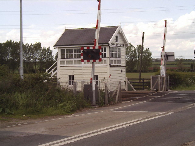
Appleby railway station (Lincolnshire)

Appleby railway station is a former railway station in Appleby, Lincolnshire, England. == History == The station was opened by the Trent, Ancholme and...

Thornholme Priory

Thornholme Priory was a priory in Lincolnshire, England, lying on the western side of the Ancholme carrs between the villages of Broughton and Appleby...

Roxby cum Risby

Roxby cum Risby is a civil parish forming part of the district of North Lincolnshire, England. The population of the civil parish at the 2011 census was...

Related Videos

POV | Forest Pines | Walking Trail

Produced for Forest Pines Hotel, Spa & Golf Resort | Broughton | North Lincolnshire.

Is this the most amazing experience Marshland Alpacas Campsite

Marshland Alpacas Campsite is located in New Holland, North Lincolnshire, which is just across the Humber Estuary for us.

Nearby Amenities

Located within 500m of 53.623139,-0.561626
Appleby
Place: village
Source: NPE
Wikidata: Q4781302
Lat/Long: 53.6216268/-0.5631518
Bus Stop
Beck Lane
Alt Name: Paul Lane
Naptan AltCommonName: Paul Lane
Naptan AltIndicator: adj
Naptan AltLandmark: Paul Lane
Naptan AltStreet: Beck Lane
Naptan AtcoCode: 227000010017
Naptan Bearing: NE
Naptan CommonName: Beck Lane
Naptan Indicator: o/s 9
Naptan NaptanCode: scuwgjd
Naptan Street: Beck Lane
Naptan Verified: no
Source: naptan_import
Lat/Long: 53.6208833/-0.5643252
Bus Stop
Beck Lane
Alt Name: Playing Field
Naptan AltCommonName: Playing Field
Naptan AltIndicator: adj
Naptan AltLandmark: Playing Field
Naptan AltStreet: Beck Lane
Naptan AtcoCode: 227000010018
Naptan Bearing: SW
Naptan CommonName: Beck Lane
Naptan Indicator: opp 9
Naptan NaptanCode: scuwmjd
Naptan Street: Beck Lane
Naptan Verified: no
Source: naptan_import
Lat/Long: 53.6208641/-0.56422
Bus Stop
Church
Naptan AtcoCode: 227000010019
Naptan Bearing: E
Naptan CommonName: Church
Naptan Indicator: o/s
Naptan NaptanCode: scuwpjd
Naptan Street: Church Lane
Naptan Verified: no
Source: naptan_import
Lat/Long: 53.6232235/-0.5608284
Bus Stop
Church
Alt Name: Haytons Lane
Naptan AltCommonName: Haytons Lane
Naptan AltIndicator: adj
Naptan AltStreet: Church Lane
Naptan AtcoCode: 227000010020
Naptan Bearing: W
Naptan CommonName: Church
Naptan Indicator: opp
Naptan NaptanCode: scuwtjd
Naptan Street: Church Lane
Naptan Verified: no
Source: naptan_import
Lat/Long: 53.6231053/-0.5614675
Bus Stop
Church Side
Alt Name: School Lane
Naptan AltCommonName: School Lane
Naptan AltIndicator: o/s 21
Naptan AltStreet: School Lane
Naptan AtcoCode: 227000010023
Naptan Bearing: E
Naptan CommonName: Church Side
Naptan Indicator: adj
Naptan NaptanCode: scuamjg
Naptan Street: School Lane
Naptan Verified: no
Source: naptan_import
Lat/Long: 53.6214601/-0.5592101
Bus Stop
Church Side
Alt Name: School Lane
Naptan AltCommonName: School Lane
Naptan AltIndicator: o/s 26
Naptan AltStreet: School Lane
Naptan AtcoCode: 227000010024
Naptan Bearing: W
Naptan CommonName: Church Side
Naptan Indicator: opp
Naptan NaptanCode: scuapjg
Naptan Street: School Lane
Naptan Verified: no
Source: naptan_import
Lat/Long: 53.6214054/-0.5591515
Ermine Farm
Place: farm
Source: Bing
Lat/Long: 53.6225383/-0.5672912
Keb Barn
Place: farm
Source: Bing
Lat/Long: 53.6231522/-0.56233
Keb Farm
Place: farm
Source: Bing
Lat/Long: 53.6254015/-0.5596448
Ermine House
Place: isolated_dwelling
Lat/Long: 53.6247141/-0.5685918
The data included in this document is from www.openstreetmap.org. The data is made available under ODbL.

Have you been to Appleby?

Leave your review of Appleby below (or comments, questions and feedback).