Birks Wood

Wood, Forest in Lancashire Fylde

England

Birks Wood

Lytham windmill and museum
Lytham windmill and museum Credit: Steve Daniels

Birks Wood is a picturesque woodland located in Lancashire, England. Nestled in the heart of the county, it covers an area of approximately 50 acres, making it a significant natural asset within the region. The wood is known for its tranquil ambiance and diverse range of flora and fauna, attracting both nature enthusiasts and casual visitors alike.

The woodland is primarily composed of broadleaf trees such as oak, beech, and birch, which create a dense canopy overhead, providing shade and shelter to the woodland floor. This rich vegetation provides a habitat for a variety of wildlife, including birds, squirrels, and deer. Bird watchers often flock to Birks Wood to catch glimpses of rare species such as the great spotted woodpecker and tawny owl.

Visitors can explore the wood via a network of well-maintained footpaths that wind through the trees, offering stunning views of the surrounding countryside. These paths are suitable for walkers of all abilities and are often used by locals for leisurely strolls or dog walking. Additionally, the wood features a small picnic area, allowing visitors to relax and enjoy the peaceful surroundings.

Birks Wood is managed by the local council, who prioritize its preservation and conservation. Regular maintenance activities, such as tree thinning and path clearing, are conducted to ensure the wood remains a safe and enjoyable environment for all. The wood is open to the public year-round, with no admission fee, making it a popular destination for families and nature enthusiasts seeking a slice of Lancashire's natural beauty.

If you have any feedback on the listing, please let us know in the comments section below.

Birks Wood Images

Images are sourced within 2km of 53.751184/-2.9534992 or Grid Reference SD3728. Thanks to Geograph Open Source API. All images are credited.

Lytham windmill and museum
Boardwalk to the jetty by Lytham RNLI Station
The boardwalk to the Lytham RNLI Station
Lytham Windmill Lytham Windmill.
Lytham Windmill
Lytham Windmill.
Lytham station, disused platform In the heyday of holiday trains to the seaside, Lytham had two platforms, of which only one is now in use.  The white notice on the wall explains that the planters, of which one is shown here, are to encourage biodiversity.  See <a href="https://www.geograph.org.uk/photo/4751426">SD3627 : A train leaving Lytham Station</a> for context.
Lytham station, disused platform
In the heyday of holiday trains to the seaside, Lytham had two platforms, of which only one is now in use. The white notice on the wall explains that the planters, of which one is shown here, are to encourage biodiversity. See SD3627 : A train leaving Lytham Station for context.
Windmill and Old Lifeboat House On Lytham Green with the former lifeboat house now having very large shelters each side
Windmill and Old Lifeboat House
On Lytham Green with the former lifeboat house now having very large shelters each side
Lytham Hall gatehouse This structure is the gatehouses (one on either side of the entrance way) marking the entrance on Ballam Road to Lytham Hall and its park. Lytham St Anne's, Lancashire.
Lytham Hall gatehouse
This structure is the gatehouses (one on either side of the entrance way) marking the entrance on Ballam Road to Lytham Hall and its park. Lytham St Anne's, Lancashire.
Lytham Hall (1) This was taken at the inner gates at Lytham Hall, Lytham St Anne's, Lancashire. Surrounded by its own woodland, Lytham Hall is a Grade I listed Georgian country house on land owned by the Clifton family since the early 17th century.
Lytham Hall (1)
This was taken at the inner gates at Lytham Hall, Lytham St Anne's, Lancashire. Surrounded by its own woodland, Lytham Hall is a Grade I listed Georgian country house on land owned by the Clifton family since the early 17th century.
To the formal garden, Lytham Hall I am on the edge of the woodland ranging to the south of Lytham Hall and looking northwards through the treeline towards the formal garden. Lytham St Anne's, Lancashire.
To the formal garden, Lytham Hall
I am on the edge of the woodland ranging to the south of Lytham Hall and looking northwards through the treeline towards the formal garden. Lytham St Anne's, Lancashire.
Curtains Pond This is Curtains Pond, located to the south west of the grounds at Lytham Hall, Lytham St Anne's, Lancashire. I am standing on the east side of the pond and the housing estate off Forest Drive can be glimpsed through the treeline.
Curtains Pond
This is Curtains Pond, located to the south west of the grounds at Lytham Hall, Lytham St Anne's, Lancashire. I am standing on the east side of the pond and the housing estate off Forest Drive can be glimpsed through the treeline.
Paradise Wall This is taken at the northern end of the Paradise Wall at Lytham Hall, built in the late 17th/early 18th century to shelter the garden from blown sand and screen the grounds from the main Heyhouses Road.
Paradise Wall
This is taken at the northern end of the Paradise Wall at Lytham Hall, built in the late 17th/early 18th century to shelter the garden from blown sand and screen the grounds from the main Heyhouses Road.
Lytham Hall (2) This is the west entrance to Lytham Hall, Lytham St Anne's, Lancashire. The main entrance faces north around the corner. The estate amenities (including café and retail) are located just beyond the north entrance as are the main Hall woods.
Lytham Hall (2)
This is the west entrance to Lytham Hall, Lytham St Anne's, Lancashire. The main entrance faces north around the corner. The estate amenities (including café and retail) are located just beyond the north entrance as are the main Hall woods.
Windmill on the Green Lytham Windmill, Lytham Green, Lytham St Anne's, Lancashire
Windmill on the Green
Lytham Windmill, Lytham Green, Lytham St Anne's, Lancashire
To Warton Bank Taken on Lytham Green, Lytham St Anne's, Lancashire, I am looking eastwards up the Ribble Estuary to Warton Bank and Warton Aerodrome and the BAE Systems manufacturing and assembly facility located at the aerodrome.
To Warton Bank
Taken on Lytham Green, Lytham St Anne's, Lancashire, I am looking eastwards up the Ribble Estuary to Warton Bank and Warton Aerodrome and the BAE Systems manufacturing and assembly facility located at the aerodrome.
Lodges and entrance gate, Lytham Hall These are the Grade II listed lodges and entrance gate to Lytham Hall, Lytham St Anne's, Lancashire.
Lodges and entrance gate, Lytham Hall
These are the Grade II listed lodges and entrance gate to Lytham Hall, Lytham St Anne's, Lancashire.
Lytham Hall This is Lytham Hall, the Grade I listed former ancestral home of the Clifton family and described as the finest Georgian house in Lancashire.
Lytham Hall
This is Lytham Hall, the Grade I listed former ancestral home of the Clifton family and described as the finest Georgian house in Lancashire.
Horse chestnut, Lytham Hall (south) This venerable horse chestnut is located on the south side of Lytham Hall, Lytham St Anne's, Lancashire.
Horse chestnut, Lytham Hall (south)
This venerable horse chestnut is located on the south side of Lytham Hall, Lytham St Anne's, Lancashire.
Lytham  Hall from the Mount I am atop The Mount, located in the grounds of Lytham Hall across the ornamental garden to the south of the house. The Mount was created in the 17th century using the soil excavated when digging Curtains Pond just to the west of the hillock.
Lytham Hall from the Mount
I am atop The Mount, located in the grounds of Lytham Hall across the ornamental garden to the south of the house. The Mount was created in the 17th century using the soil excavated when digging Curtains Pond just to the west of the hillock.
Show me another place!

Birks Wood is located at Grid Ref: SD3728 (Lat: 53.751184, Lng: -2.9534992)

Administrative County: Lancashire

District: Fylde

Police Authority: Lancashire

What 3 Words

///flushes.poetry.trifle. Near Lytham St Annes, Lancashire

Related Wikis

St Bede's Catholic High School, Lytham St Annes

St Bede's Catholic High School is a coeducational secondary school located in the Lytham area of Lytham St Annes in the English county of Lancashire.Established...

Lytham (Station Road) railway station

The original Lytham railway station was the Lytham terminus of a branch of the Preston and Wyre Joint Railway from Kirkham in Lancashire, England. It opened...
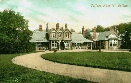
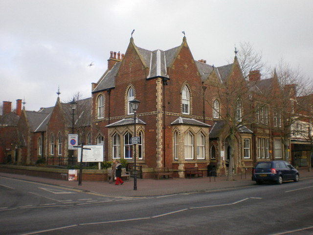
Lytham Hospital

Lytham Hospital is a health facility in Lytham St Annes, Lancashire. It is managed by Lancashire Care NHS Foundation Trust. == History == === Cottage... ===

Lytham railway station

Lytham railway station serves the Lytham area within Lytham St Annes, Lancashire, England, on the Blackpool South to Preston railway line. == Services... ==

Lytham Library

Lytham library was built originally as a Mechanics Institute. It included a small library of books and a reading room and opened on 30 August 1878. The...
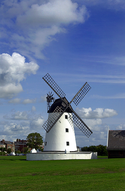
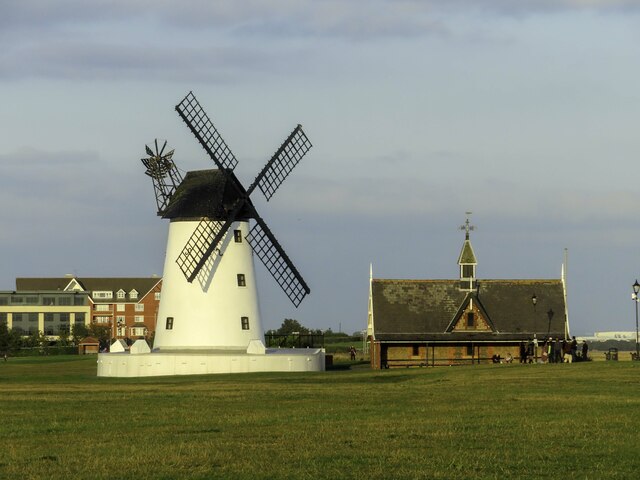
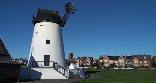
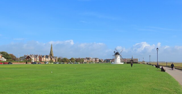
Lytham Windmill

Lytham Windmill is situated on Lytham Green in the coastal town of Lytham St Annes, Lancashire, England. It is of the type known as a tower mill and was...

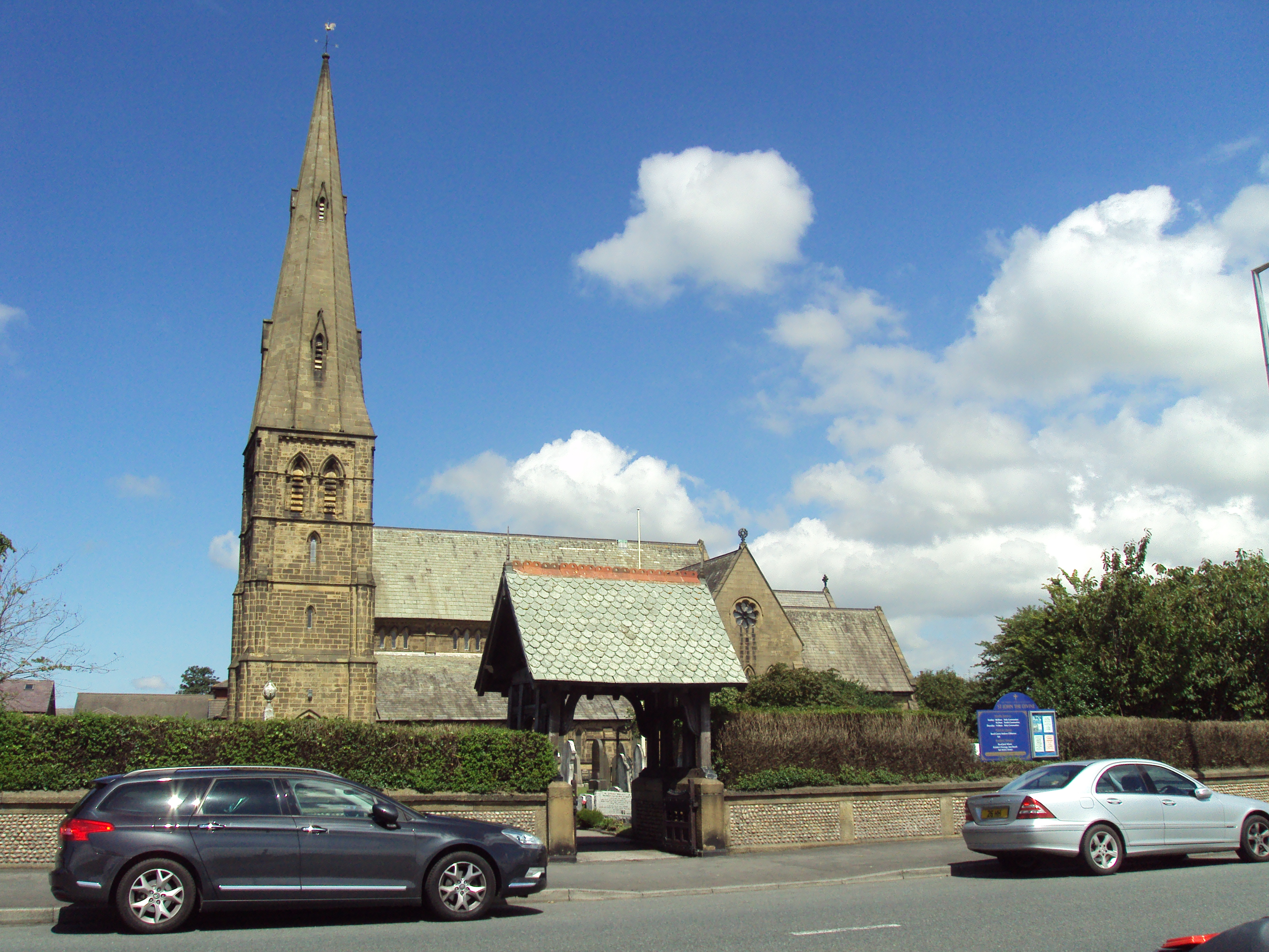
St John's Church, Lytham

St John's Church is in East Beach, Lytham St Annes, Lancashire, England. It is an active Anglican parish church in the deanery of Kirkham, the archdeaconry...

Moss Side railway station

Moss Side railway station is on the Blackpool South-to-Preston line, in Lancashire, England. It is located in Moss Side, a hamlet where the B5259 (Lytham...

Nearby Amenities

Located within 500m of 53.751184,-2.9534992
Golf: pin
Lat/Long: 53.7486658/-2.9489171
Golf: pin
Lat/Long: 53.7506517/-2.9519867
Golf: pin
Lat/Long: 53.7481363/-2.9533862
Golf: pin
Lat/Long: 53.7486251/-2.9575612
Golf: pin
Lat/Long: 53.7476104/-2.9539964
Golf: pin
Lat/Long: 53.7508989/-2.9606915
Golf: pin
Lat/Long: 53.7481733/-2.9579785
Golf: pin
Lat/Long: 53.7496236/-2.9535705
Golf: pin
Lat/Long: 53.7502553/-2.9528988
Golf: pin
Lat/Long: 53.7502156/-2.9581557
Golf: pin
Lat/Long: 53.7505616/-2.9565585
Golf: pin
Lat/Long: 53.750168/-2.9608077
The data included in this document is from www.openstreetmap.org. The data is made available under ODbL.

Have you been to Birks Wood?

Leave your review of Birks Wood below (or comments, questions and feedback).