Westmills Plantation
Wood, Forest in Dorset
England
Westmills Plantation
Westmills Plantation, located in Dorset, is a picturesque woodland area renowned for its lush greenery and serene ambiance. Spanning over several acres, this plantation is a haven for nature enthusiasts and those seeking tranquility amidst nature's beauty.
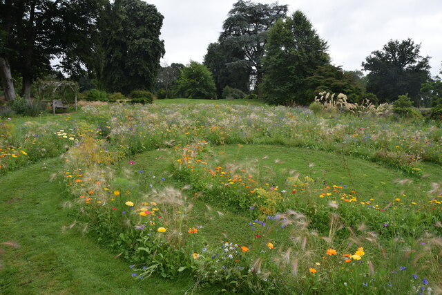
The plantation boasts a diverse range of trees, including oak, beech, and pine, which add to its scenic charm. These trees provide a dense canopy, creating a cool and refreshing atmosphere even on hot summer days. The forest floor is adorned with a vibrant carpet of moss and ferns, further enhancing the enchanting appeal of the woodland.
Westmills Plantation is home to a variety of wildlife, making it a popular spot for birdwatchers and animal lovers. Visitors can spot a range of species, including deer, foxes, squirrels, and a plethora of bird species, creating a wonderful opportunity for nature photography and observation.
Nature trails wind their way through the plantation, allowing visitors to explore and immerse themselves in the natural surroundings. These trails are well-maintained and offer stunning views of the surrounding countryside. The plantation also features picnic areas and benches, providing visitors with the perfect opportunity to relax and enjoy a peaceful picnic amidst the tranquil setting.
Westmills Plantation is easily accessible, with ample parking available for visitors. It is a popular destination for families, nature enthusiasts, and those seeking solace in nature. With its breathtaking beauty and abundant wildlife, Westmills Plantation is a must-visit for anyone looking to escape the hustle and bustle of city life and reconnect with nature.
If you have any feedback on the listing, please let us know in the comments section below.
Westmills Plantation Images
Images are sourced within 2km of 50.84043/-2.9207076 or Grid Reference ST3504. Thanks to Geograph Open Source API. All images are credited.
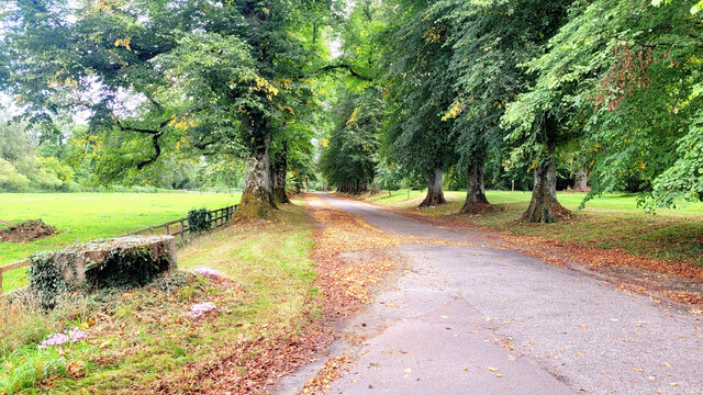
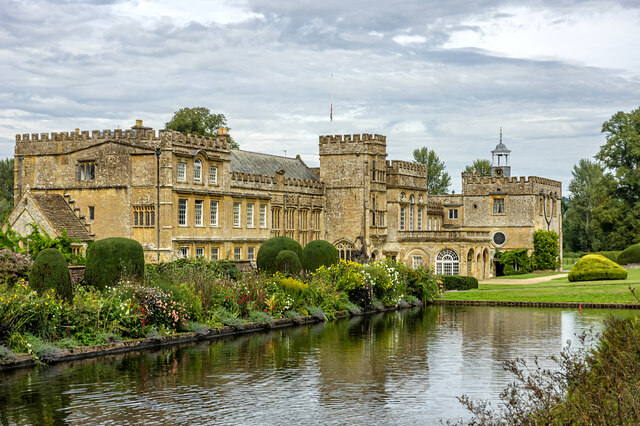

![Forde Abbey and Gardens [1] The entrance avenue, looking out towards the entrance gate.
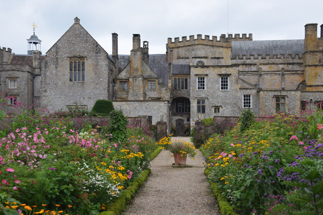
Forde Abbey and Gardens is situated in Dorset, on the south bank of the River Axe, some 5½ miles northeast of Axminster and about 3 miles southeast of Chard. A Cistercian Abbey was founded in 1136, and after dissolution in 1539, it was partly converted into a Country House. Parts of the monastic buildings of the 12th, 13th, 15th and 16th centuries survive with alterations, extensions and restorations in the 17th, 19th and 20th centuries. The house is constructed of rubble stone with Ham stone ashlar and dressings under roofs of slate and lead. The house is listed, grade I, with details at: <span class="nowrap"><a title="https://historicengland.org.uk/listing/the-list/list-entry/1153362" rel="nofollow ugc noopener" href="https://historicengland.org.uk/listing/the-list/list-entry/1153362">Link</a><img style="margin-left:2px;" alt="External link" title="External link - shift click to open in new window" src="https://s1.geograph.org.uk/img/external.png" width="10" height="10"/></span> Part of the gardens, in which the abbey church and northern cloister survive as buried structures, are a Scheduled Ancient Monument with details at: <span class="nowrap"><a title="https://historicengland.org.uk/listing/the-list/list-entry/1002347" rel="nofollow ugc noopener" href="https://historicengland.org.uk/listing/the-list/list-entry/1002347">Link</a><img style="margin-left:2px;" alt="External link" title="External link - shift click to open in new window" src="https://s1.geograph.org.uk/img/external.png" width="10" height="10"/></span> The site has some 15 acres of formal gardens and pleasure grounds, and about 65 acres of parkland. The grounds are on the Register of Historic Parks and Gardens, grade II*, with details at: <span class="nowrap"><a title="https://historicengland.org.uk/listing/the-list/list-entry/1000717" rel="nofollow ugc noopener" href="https://historicengland.org.uk/listing/the-list/list-entry/1000717">Link</a><img style="margin-left:2px;" alt="External link" title="External link - shift click to open in new window" src="https://s1.geograph.org.uk/img/external.png" width="10" height="10"/></span>](https://s0.geograph.org.uk/geophotos/07/56/74/7567492_92989d94.jpg)
![Forde Abbey and Gardens [2] The seven bays of arches are the north alley of the former cloister.
Forde Abbey and Gardens is situated in Dorset, on the south bank of the River Axe, some 5½ miles northeast of Axminster and about 3 miles southeast of Chard. A Cistercian Abbey was founded in 1136, and after dissolution in 1539, it was partly converted into a Country House. Parts of the monastic buildings of the 12th, 13th, 15th and 16th centuries survive with alterations, extensions and restorations in the 17th, 19th and 20th centuries. The house is constructed of rubble stone with Ham stone ashlar and dressings under roofs of slate and lead. The house is listed, grade I, with details at: <span class="nowrap"><a title="https://historicengland.org.uk/listing/the-list/list-entry/1153362" rel="nofollow ugc noopener" href="https://historicengland.org.uk/listing/the-list/list-entry/1153362">Link</a><img style="margin-left:2px;" alt="External link" title="External link - shift click to open in new window" src="https://s1.geograph.org.uk/img/external.png" width="10" height="10"/></span> Part of the gardens, in which the abbey church and northern cloister survive as buried structures, are a Scheduled Ancient Monument with details at: <span class="nowrap"><a title="https://historicengland.org.uk/listing/the-list/list-entry/1002347" rel="nofollow ugc noopener" href="https://historicengland.org.uk/listing/the-list/list-entry/1002347">Link</a><img style="margin-left:2px;" alt="External link" title="External link - shift click to open in new window" src="https://s1.geograph.org.uk/img/external.png" width="10" height="10"/></span> The site has some 15 acres of formal gardens and pleasure grounds, and about 65 acres of parkland. The grounds are on the Register of Historic Parks and Gardens, grade II*, with details at: <span class="nowrap"><a title="https://historicengland.org.uk/listing/the-list/list-entry/1000717" rel="nofollow ugc noopener" href="https://historicengland.org.uk/listing/the-list/list-entry/1000717">Link</a><img style="margin-left:2px;" alt="External link" title="External link - shift click to open in new window" src="https://s1.geograph.org.uk/img/external.png" width="10" height="10"/></span>](https://s1.geograph.org.uk/geophotos/07/56/74/7567497_3e4cc0be.jpg)
![Forde Abbey and Gardens [3] The Dorter range with the Chapter House. The 13 bay Dorter range is 13th century. The Chapter House (now the chapel) is mid 12th century, the upper part was rebuilt in the 16th century and altered in the late 17th century.
Forde Abbey and Gardens is situated in Dorset, on the south bank of the River Axe, some 5½ miles northeast of Axminster and about 3 miles southeast of Chard. A Cistercian Abbey was founded in 1136, and after dissolution in 1539, it was partly converted into a Country House. Parts of the monastic buildings of the 12th, 13th, 15th and 16th centuries survive with alterations, extensions and restorations in the 17th, 19th and 20th centuries. The house is constructed of rubble stone with Ham stone ashlar and dressings under roofs of slate and lead. The house is listed, grade I, with details at: <span class="nowrap"><a title="https://historicengland.org.uk/listing/the-list/list-entry/1153362" rel="nofollow ugc noopener" href="https://historicengland.org.uk/listing/the-list/list-entry/1153362">Link</a><img style="margin-left:2px;" alt="External link" title="External link - shift click to open in new window" src="https://s1.geograph.org.uk/img/external.png" width="10" height="10"/></span> Part of the gardens, in which the abbey church and northern cloister survive as buried structures, are a Scheduled Ancient Monument with details at: <span class="nowrap"><a title="https://historicengland.org.uk/listing/the-list/list-entry/1002347" rel="nofollow ugc noopener" href="https://historicengland.org.uk/listing/the-list/list-entry/1002347">Link</a><img style="margin-left:2px;" alt="External link" title="External link - shift click to open in new window" src="https://s1.geograph.org.uk/img/external.png" width="10" height="10"/></span> The site has some 15 acres of formal gardens and pleasure grounds, and about 65 acres of parkland. The grounds are on the Register of Historic Parks and Gardens, grade II*, with details at: <span class="nowrap"><a title="https://historicengland.org.uk/listing/the-list/list-entry/1000717" rel="nofollow ugc noopener" href="https://historicengland.org.uk/listing/the-list/list-entry/1000717">Link</a><img style="margin-left:2px;" alt="External link" title="External link - shift click to open in new window" src="https://s1.geograph.org.uk/img/external.png" width="10" height="10"/></span>](https://s2.geograph.org.uk/geophotos/07/56/75/7567502_6b6fd65a.jpg)
![Forde Abbey and Gardens [4] The Chapter House is now the chapel. Built in the 12th century, the upper part was rebuilt in the 16th century and altered in the late 17th century. The east window is early 16th century.
Forde Abbey and Gardens is situated in Dorset, on the south bank of the River Axe, some 5½ miles northeast of Axminster and about 3 miles southeast of Chard. A Cistercian Abbey was founded in 1136, and after dissolution in 1539, it was partly converted into a Country House. Parts of the monastic buildings of the 12th, 13th, 15th and 16th centuries survive with alterations, extensions and restorations in the 17th, 19th and 20th centuries. The house is constructed of rubble stone with Ham stone ashlar and dressings under roofs of slate and lead. The house is listed, grade I, with details at: <span class="nowrap"><a title="https://historicengland.org.uk/listing/the-list/list-entry/1153362" rel="nofollow ugc noopener" href="https://historicengland.org.uk/listing/the-list/list-entry/1153362">Link</a><img style="margin-left:2px;" alt="External link" title="External link - shift click to open in new window" src="https://s1.geograph.org.uk/img/external.png" width="10" height="10"/></span> Part of the gardens, in which the abbey church and northern cloister survive as buried structures, are a Scheduled Ancient Monument with details at: <span class="nowrap"><a title="https://historicengland.org.uk/listing/the-list/list-entry/1002347" rel="nofollow ugc noopener" href="https://historicengland.org.uk/listing/the-list/list-entry/1002347">Link</a><img style="margin-left:2px;" alt="External link" title="External link - shift click to open in new window" src="https://s1.geograph.org.uk/img/external.png" width="10" height="10"/></span> The site has some 15 acres of formal gardens and pleasure grounds, and about 65 acres of parkland. The grounds are on the Register of Historic Parks and Gardens, grade II*, with details at: <span class="nowrap"><a title="https://historicengland.org.uk/listing/the-list/list-entry/1000717" rel="nofollow ugc noopener" href="https://historicengland.org.uk/listing/the-list/list-entry/1000717">Link</a><img style="margin-left:2px;" alt="External link" title="External link - shift click to open in new window" src="https://s1.geograph.org.uk/img/external.png" width="10" height="10"/></span>](https://s2.geograph.org.uk/geophotos/07/56/75/7567506_62eed627.jpg)
Westmills Plantation is located at Grid Ref: ST3504 (Lat: 50.84043, Lng: -2.9207076)
Unitary Authority: Dorset
Police Authority: Dorset
What 3 Words
///twit.them.gobbling. Near Chard, Somerset
Nearby Locations
Related Wikis

Forde Abbey
Forde Abbey is a privately owned former Cistercian monastery in Dorset, England, with a postal address in Chard, Somerset. The house and gardens are run...

Chard Junction railway station
Chard Junction railway station was situated on the London and South Western Railway’s West of England Main Line about 1 mile (1.6 km) southeast of the...

Leigh House
Leigh House is 16th- or 17th-century house in Winsham, Somerset, England. It is a Grade II* listed building.The site was previously part of the Forde Abbey...

Stowell Meadow
Stowell Meadow (grid reference ST333062) is a 2.8 hectare (6.9 acre) biological Site of Special Scientific Interest near Tatworth in Somerset, notified...

Church of St Stephen, Winsham
The Anglican Church of St Stephen in Winsham, Somerset, England, was built in the 13th century. It is a Grade II* listed building. == History == The church...

Winsham
Winsham is a village and civil parish 4 miles (6 km) south-east of Chard and 6 miles (10 km) from Crewkerne, in the South Somerset district of Somerset...
Church of St John the Evangelist, Tatworth
The Church of St John the Evangelist is a Church of England parish church in Tatworth, Somerset, England. It was built in 1850–51 to the design of Charles...
Tatworth
Tatworth is a village 2 miles (3 km) south of Chard in the South Somerset district of the county of Somerset, England. It is within Tatworth and Forton...
Nearby Amenities
Located within 500m of 50.84043,-2.9207076Have you been to Westmills Plantation?
Leave your review of Westmills Plantation below (or comments, questions and feedback).