Ashcombe Wood

Wood, Forest in Somerset

England

Ashcombe Wood

The Grand Pier at Weston-Super-Mare View looking in a southerly direction
The Grand Pier at Weston-Super-Mare Credit: John Smitten

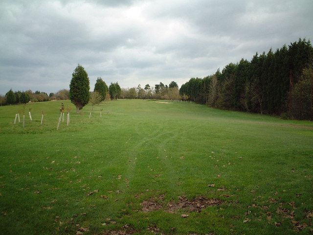
Ashcombe Wood is a picturesque woodland situated in Somerset, England. Covering an area of approximately 100 acres, it is nestled within the beautiful countryside of the Mendip Hills. The wood is part of the larger Ashcombe Estate and is managed by the Forestry Commission.

Ashcombe Wood boasts an impressive variety of tree species, including oak, beech, ash, and birch. These towering trees form a dense canopy, creating a cool and shady environment beneath. The forest floor is adorned with a diverse range of flora, such as bluebells, primroses, and wood anemones, which create a vibrant display during the spring months.

Popular with nature enthusiasts and walkers, Ashcombe Wood offers a network of well-maintained footpaths that wind through the woodland. These paths provide the opportunity to explore the different areas of the wood and discover its hidden treasures. Additionally, the wood is home to an abundance of wildlife, including deer, squirrels, and a variety of bird species, making it a haven for wildlife enthusiasts and birdwatchers.

Visitors to Ashcombe Wood can also enjoy the tranquil atmosphere and peaceful surroundings. The wood offers numerous picnic spots, allowing visitors to relax and immerse themselves in nature. It is a perfect place for families and individuals alike to escape the hustle and bustle of everyday life and enjoy a peaceful day out in the countryside.

Overall, Ashcombe Wood is a stunning natural gem in Somerset, offering a rich variety of flora and fauna, tranquil surroundings, and picturesque walking trails, making it a must-visit destination for nature lovers and those seeking a peaceful retreat.

If you have any feedback on the listing, please let us know in the comments section below.

Ashcombe Wood Images

Images are sourced within 2km of 51.357024/-2.9629552 or Grid Reference ST3362. Thanks to Geograph Open Source API. All images are credited.

The Grand Pier at Weston-Super-Mare View looking in a southerly direction
The Grand Pier at Weston-Super-Mare
View looking in a southerly direction
Knightstone Island Knightstone Island has been given planning permission to convert some of the buildings to residential properties
Knightstone Island
Knightstone Island has been given planning permission to convert some of the buildings to residential properties
Italian Gardens Italian Gardens in the High St Weston-Super-Mare
Italian Gardens
Italian Gardens in the High St Weston-Super-Mare
South end of Sand Bay Picture taken on the beach directly in front of the car park south end of Sand Bay. you can also see the Old Pier at Weston-super-mare
South end of Sand Bay
Picture taken on the beach directly in front of the car park south end of Sand Bay. you can also see the Old Pier at Weston-super-mare
Kewstoke Village Green
Locking Road car park Locking Road car park appears as the large white area on the map and is normally busy with shoppers/holiday makers during the day, and coaches and trucks during the night. Once a year, however, it is used as the assembly area for the floats taking part in the Weston-super-Mare carnival procession. This is a view taken from the flyover and shows the floats preparing for the 2004 procession.  The largest of these floats employ 1MW generators and can be 100 feet long. The 2005 procession will be held on Monday 14th November. See <span class="nowrap"><a title="https://carnivalphotos.zenfolio.com/" rel="nofollow ugc noopener" href="https://carnivalphotos.zenfolio.com/">Link</a><img style="margin-left:2px;" alt="External link" title="External link - shift click to open in new window" src="https://s1.geograph.org.uk/img/external.png" width="10" height="10"/></span> for further pictures of Somerset and Wessex illuminated carnivals.
Locking Road car park
Locking Road car park appears as the large white area on the map and is normally busy with shoppers/holiday makers during the day, and coaches and trucks during the night. Once a year, however, it is used as the assembly area for the floats taking part in the Weston-super-Mare carnival procession. This is a view taken from the flyover and shows the floats preparing for the 2004 procession. The largest of these floats employ 1MW generators and can be 100 feet long. The 2005 procession will be held on Monday 14th November. See LinkExternal link for further pictures of Somerset and Wessex illuminated carnivals.
Rozel House Rozel House now stands on the site of the former Rozel Hotel
Rozel House
Rozel House now stands on the site of the former Rozel Hotel
Town Quarry Disused town quarry is now a nature reserve with a cafe, gallery & arts & craft shop.
Town Quarry
Disused town quarry is now a nature reserve with a cafe, gallery & arts & craft shop.
Ashcombe Park Tea Shop
Baytree Road Looking down Baytree Road
Baytree Road
Looking down Baytree Road
Hornets Rugby Ground
Locking Road, Weston Super Mare
Worlebury Golf Course Looking out from the 4th Tee
Worlebury Golf Course
Looking out from the 4th Tee
Golfers on the 4th Tee Worlebury Golf course
Golfers on the 4th Tee
Worlebury Golf course
Weston-super-Mare: Worlebury hillfort Recent tree clearance of part of the 10-acre site, in the hands of North Somerset Council, has revealed some of the 93 storage pits first discovered in the 1850s, when the site was excavated by a group of antiquarians. Grain was found in a number of the pits, which are unusually large at 6 to 8 feet in diameter and typically 6 feet deep. For a good guide to the hillfort, see ‘Worlebury. The story of the Iron Age hill-fort at Weston-super-Mare’, obtainable from Woodspring Museum, Burlington Street, Weston-super-Mare BS23 1PR. Phone 01934 612006
Weston-super-Mare: Worlebury hillfort
Recent tree clearance of part of the 10-acre site, in the hands of North Somerset Council, has revealed some of the 93 storage pits first discovered in the 1850s, when the site was excavated by a group of antiquarians. Grain was found in a number of the pits, which are unusually large at 6 to 8 feet in diameter and typically 6 feet deep. For a good guide to the hillfort, see ‘Worlebury. The story of the Iron Age hill-fort at Weston-super-Mare’, obtainable from Woodspring Museum, Burlington Street, Weston-super-Mare BS23 1PR. Phone 01934 612006
Weston-super-Mare: Worlebury hillfort Recent tree clearance of part of the 10-acre site, in the hands of North Somerset Council, has revealed some of the 93 storage pits first discovered in the 1850s, when the site was excavated by a group of antiquarians. Grain was found in a number of the pits, which are unusually large at 6 to 8 feet in diameter and typically 6 feet deep
Weston-super-Mare: Worlebury hillfort
Recent tree clearance of part of the 10-acre site, in the hands of North Somerset Council, has revealed some of the 93 storage pits first discovered in the 1850s, when the site was excavated by a group of antiquarians. Grain was found in a number of the pits, which are unusually large at 6 to 8 feet in diameter and typically 6 feet deep
Art Deco Burton Shop, Regent Street, Weston-super-Mare In fine appearance, this Burton Shop is one of many Art Deco buildings in Weston-super-Mare. This one is in Egyptian style and is situated on the corner of Regent Street and High Street. Many Burton stores originally had snooker rooms above with tall ceilings and windows.
Art Deco Burton Shop, Regent Street, Weston-super-Mare
In fine appearance, this Burton Shop is one of many Art Deco buildings in Weston-super-Mare. This one is in Egyptian style and is situated on the corner of Regent Street and High Street. Many Burton stores originally had snooker rooms above with tall ceilings and windows.
Art Deco Odeon Cinema, Walliscote Road, Weston-Super-Mare This fine Art Deco Grade II Listed Odeon Cinema was opened on 25th May 1935. The architect was T. Cecil Howitt. Although now a 4 screen multiplex the art deco proscenium arch of the main auditorium and other features are retained. Also retained is one of the two remaining cinema organs still installed in a functioning UK cinema. There are regular concerts. The cinema is situated on the corner of Walliscote Road and Locking Road. <span class="nowrap"><a title="http://cinematreasures.org/theater/13851/" rel="nofollow ugc noopener" href="http://cinematreasures.org/theater/13851/">Link</a><img style="margin-left:2px;" alt="External link" title="External link - shift click to open in new window" src="https://s1.geograph.org.uk/img/external.png" width="10" height="10"/></span>
Art Deco Odeon Cinema, Walliscote Road, Weston-Super-Mare
This fine Art Deco Grade II Listed Odeon Cinema was opened on 25th May 1935. The architect was T. Cecil Howitt. Although now a 4 screen multiplex the art deco proscenium arch of the main auditorium and other features are retained. Also retained is one of the two remaining cinema organs still installed in a functioning UK cinema. There are regular concerts. The cinema is situated on the corner of Walliscote Road and Locking Road. LinkExternal link
Show me another place!

Ashcombe Wood is located at Grid Ref: ST3362 (Lat: 51.357024, Lng: -2.9629552)

Unitary Authority: North Somerset

Police Authority: Avon and Somerset

What 3 Words

///magic.notes.sudden. Near Kewstoke, Somerset

Related Wikis

Weston-super-Mare Ashcombe Road railway station

Weston-super-Mare Ashcombe Road railway station served the town of Weston-super-Mare, Somerset, England, from 1897 to 1940 on the Weston, Clevedon and...

Lambretta Scooter Museum

The Lambretta Scooter Museum is in Weston-super-Mare, Somerset, England. It houses a total of 61 Lambretta models – at least one from each year between...

Worlebury Hill

Worlebury Hill is the name given to an upland area lying between the flatlands of Weston-super-Mare and the Kewstoke area of North Somerset, England. Worlebury...

Kewstoke

Kewstoke is a civil parish and village in Somerset, England, within the unitary authority of North Somerset, located next to the strip of coast called...

Nearby Amenities

Located within 500m of 51.357024,-2.9629552
Turning Circle
Lat/Long: 51.3534456/-2.9641034
Bus Stop
Weston Woods
Bus: yes
Naptan AtcoCode: 0190NSC30251
Naptan Bearing: W
Naptan CommonName: Weston Woods
Naptan Crossing: Worlebury Park Road
Naptan NaptanCode: wsmapmd
Naptan PlusbusZoneRef: WSMARE
Naptan Street: Worlebury Hill Road
Naptan Verified: no
Public Transport: platform
Source: naptan_import
Lat/Long: 51.3597118/-2.9580422
Bus Stop
Cliff Road
Bus: yes
Naptan AtcoCode: 0190NSC30252
Naptan Bearing: N
Naptan CommonName: Cliff Road
Naptan NaptanCode: wsmapdw
Naptan PlusbusZoneRef: WSMARE
Naptan Street: Cliff Road
Naptan Verified: no
Public Transport: platform
Source: naptan_import
Lat/Long: 51.3607729/-2.9602517
Bus Stop
Ashcombe Park Road
Bus: yes
Naptan AtcoCode: 0190NSC30266
Naptan Bearing: E
Naptan CommonName: Ashcombe Park Road
Naptan Crossing: Rockingham Grove
Naptan NaptanCode: wsmapmt
Naptan PlusbusZoneRef: WSMARE
Naptan Street: Upper Bristol Road
Naptan Verified: no
Public Transport: platform
Source: naptan_import
Lat/Long: 51.3550309/-2.9578858
Bus Stop
Ashcombe Park Road
Bus: yes
Naptan AtcoCode: 0190NSC30267
Naptan Bearing: W
Naptan CommonName: Ashcombe Park Road
Naptan Crossing: Pennine Gardens
Naptan NaptanCode: wsmapja
Naptan PlusbusZoneRef: WSMARE
Naptan Street: Upper Bristol Road
Naptan Verified: no
Public Transport: platform
Source: naptan_import
Lat/Long: 51.3548376/-2.9593364
Bus Stop
Forest Drive
Bus: yes
Naptan AtcoCode: 0190NSC30269
Naptan Bearing: E
Naptan CommonName: Forest Drive
Naptan Crossing: Snowdon Vale
Naptan NaptanCode: wsmapaj
Naptan PlusbusZoneRef: WSMARE
Naptan Street: Upper Bristol Road
Naptan Verified: no
Public Transport: platform
Source: naptan_import
Lat/Long: 51.355031/-2.9609114
Bus Stop
Manor Road
Bus: yes
Naptan AtcoCode: 0190NSC30270
Naptan Bearing: W
Naptan CommonName: Manor Road
Naptan Crossing: Manor Road
Naptan NaptanCode: wsmamja
Naptan PlusbusZoneRef: WSMARE
Naptan Street: Bristol Road Lower
Naptan Verified: no
Public Transport: platform
Source: naptan_import
Lat/Long: 51.3545408/-2.9643636
Bus Stop
Manor Road
Bus: yes
Naptan AtcoCode: 0190NSC30272
Naptan Bearing: E
Naptan CommonName: Manor Road
Naptan Crossing: Eastcombe Gardens
Naptan NaptanCode: wsmamgp
Naptan PlusbusZoneRef: WSMARE
Naptan Street: Bristol Road Lower
Naptan Verified: no
Public Transport: platform
Source: naptan_import
Lat/Long: 51.3546165/-2.9647519
Bus Stop
Cemetery
Bus: yes
Naptan AtcoCode: 0190NSC30273
Naptan Bearing: W
Naptan CommonName: Cemetery
Naptan NaptanCode: wsmamdm
Naptan PlusbusZoneRef: WSMARE
Naptan Street: Bristol Road Lower
Naptan Verified: no
Public Transport: platform
Source: naptan_import
Lat/Long: 51.3541658/-2.9671568
Bus Stop
Cemetery
Bus: yes
Naptan AtcoCode: 0190NSC30274
Naptan Bearing: N
Naptan CommonName: Cemetery
Naptan Crossing: Bristol Road Lower
Naptan NaptanCode: wsmamdg
Naptan PlusbusZoneRef: WSMARE
Naptan Street: Eastfield Gardens
Naptan Verified: no
Public Transport: platform
Source: naptan_import
Lat/Long: 51.3542421/-2.9679149
Turning Circle
Lat/Long: 51.3535949/-2.9662305
Turning Circle
Lat/Long: 51.3530794/-2.9661164
Addr Housenumber: 59
Addr Postcode: BS23 2XH
Addr Street: Ashcombe Gardens
Lat/Long: 51.3539245/-2.9620463
Addr Housenumber: 61
Addr Postcode: BS23 2XH
Addr Street: Ashcombe Gardens
Lat/Long: 51.3539237/-2.9621337
Addr Housenumber: 63
Addr Postcode: BS23 2XH
Addr Street: Ashcombe Gardens
Lat/Long: 51.3539884/-2.9620413
Addr Housenumber: 65
Addr Postcode: BS23 2XH
Addr Street: Ashcombe Gardens
Lat/Long: 51.3539875/-2.9621351
Addr Housenumber: 67
Addr Postcode: BS23 2XH
Addr Street: Ashcombe Gardens
Lat/Long: 51.3540575/-2.9621267
Addr Housenumber: 75
Addr Postcode: BS23 2XH
Addr Street: Ashcombe Gardens
Lat/Long: 51.3542341/-2.9621309
Addr Housenumber: 75
Addr Postcode: BS23 2XH
Addr Street: Ashcombe Gardens
Lat/Long: 51.3542779/-2.9620077
Addr Housenumber: 79
Addr Postcode: BS23 2XH
Addr Street: Ashcombe Gardens
Lat/Long: 51.3542954/-2.9621085
Addr Housenumber: 73
Addr Postcode: BS23 2XH
Addr Street: Ashcombe Gardens
Lat/Long: 51.3542175/-2.9620245
Addr Housenumber: 71
Addr Postcode: BS23 2XH
Addr Street: Ashcombe Gardens
Lat/Long: 51.3541694/-2.9621673
Addr Housenumber: 69
Addr Postcode: BS23 2XH
Addr Street: Ashcombe Gardens
Lat/Long: 51.3541528/-2.9620651
Addr Housenumber: 57
Addr Postcode: BS23 2XH
Addr Street: Ashcombe Gardens
Lat/Long: 51.3538102/-2.9620713
Addr Housenumber: 55
Addr Postcode: BS23 2XH
Addr Street: Ashcombe Gardens
Lat/Long: 51.3538255/-2.9619851
Addr Housenumber: 53
Addr Postcode: BS23 2XH
Addr Street: Ashcombe Gardens
Lat/Long: 51.3537484/-2.9620468
Addr Housenumber: 51
Addr Postcode: BS23 2XH
Addr Street: Ashcombe Gardens
Lat/Long: 51.3537666/-2.9619456
Addr Housenumber: 49
Addr Postcode: BS23 2XH
Addr Street: Ashcombe Gardens
Lat/Long: 51.3536859/-2.9620259
Addr Housenumber: 47
Addr Postcode: BS23 2XH
Addr Street: Ashcombe Gardens
Lat/Long: 51.3537041/-2.9619351
Addr Housenumber: 40
Addr Postcode: BS23 2SU
Addr Street: Manor Road
Lat/Long: 51.3528809/-2.962554
Addr Housenumber: 40A
Addr Postcode: BS23 2SU
Addr Street: Manor Road
Lat/Long: 51.3529033/-2.9624514
Addr Housenumber: 50
Addr Postcode: BS23 2XH
Addr Street: Ashcombe Gardens
Lat/Long: 51.3535609/-2.9613077
Addr Housenumber: 52
Addr Postcode: BS23 2XH
Addr Street: Ashcombe Gardens
Lat/Long: 51.3535838/-2.9612174
Addr Housenumber: 54
Addr Postcode: BS23 2XH
Addr Street: Ashcombe Gardens
Lat/Long: 51.3536287/-2.9613613
Addr Housenumber: 56
Addr Postcode: BS23 2XH
Addr Street: Ashcombe Gardens
Lat/Long: 51.3536462/-2.9612699
Addr Housenumber: 58
Addr Postcode: BS23 2XH
Addr Street: Ashcombe Gardens
Lat/Long: 51.3536858/-2.9613857
Addr Housenumber: 60
Addr Postcode: BS23 2XH
Addr Street: Ashcombe Gardens
Lat/Long: 51.3537087/-2.9612979
Addr Housenumber: 62
Addr Postcode: BS23 2XH
Addr Street: Ashcombe Gardens
Lat/Long: 51.3538807/-2.9615369
Addr Housenumber: 64
Addr Postcode: BS23 2XH
Addr Street: Ashcombe Gardens
Lat/Long: 51.3538929/-2.961454
Addr Housenumber: 66
Addr Postcode: BS23 2XH
Addr Street: Ashcombe Gardens
Lat/Long: 51.3539264/-2.9613979
Addr Housenumber: 68
Addr Postcode: BS23 2XH
Addr Street: Ashcombe Gardens
Lat/Long: 51.3542104/-2.9614259
Addr Housenumber: 70
Addr Postcode: BS23 2XH
Addr Street: Ashcombe Gardens
Lat/Long: 51.3542188/-2.9613418
Addr Housenumber: 72
Addr Postcode: BS23 2XH
Addr Street: Ashcombe Gardens
Lat/Long: 51.3542751/-2.9614454
Addr Housenumber: 74
Addr Postcode: BS23 2XH
Addr Street: Ashcombe Gardens
Lat/Long: 51.354282/-2.9613625
Addr Housenumber: 76
Addr Postcode: BS23 2XH
Addr Street: Ashcombe Gardens
Lat/Long: 51.3543391/-2.9614649
Addr Housenumber: 78
Addr Postcode: BS23 2XH
Addr Street: Ashcombe Gardens
Lat/Long: 51.3543513/-2.9613747
Addr Housenumber: 12
Addr Postcode: BS23 2XP
Addr Street: Snowdon Vale
Lat/Long: 51.3540898/-2.9612224
Addr Housenumber: 14
Addr Postcode: BS23 2XP
Addr Street: Snowdon Vale
Lat/Long: 51.354057/-2.9611736
Addr Housenumber: 16
Addr Postcode: BS23 2XP
Addr Street: Snowdon Vale
Lat/Long: 51.3540174/-2.9611175
Addr Housenumber: 18
Addr Postcode: BS23 2XP
Addr Street: Snowdon Vale
Lat/Long: 51.3539816/-2.9610663
Addr Housenumber: 20
Addr Postcode: BS23 2XP
Addr Street: Snowdon Vale
Lat/Long: 51.3538263/-2.9610858
Addr Housenumber: 22
Addr Postcode: BS23 2XP
Addr Street: Snowdon Vale
Lat/Long: 51.3537936/-2.9610346
Addr Housenumber: 24
Addr Postcode: BS23 2XP
Addr Street: Snowdon Vale
Lat/Long: 51.3537578/-2.9609798
Addr Housenumber: 26
Addr Postcode: BS23 2XP
Addr Street: Snowdon Vale
Lat/Long: 51.3537212/-2.9609249
Addr Housenumber: 5
Addr Postcode: BS23 2XS
Addr Street: Pennine Gardens
Lat/Long: 51.3544757/-2.960368
Addr Housenumber: 7
Addr Postcode: BS23 2XS
Addr Street: Pennine Gardens
Lat/Long: 51.3544348/-2.9603614
Addr Housenumber: 9
Addr Postcode: BS23 2XS
Addr Street: Pennine Gardens
Lat/Long: 51.3544674/-2.9604648
Addr Housenumber: 11
Addr Postcode: BS23 2XS
Addr Street: Pennine Gardens
Lat/Long: 51.3544271/-2.9604592
Addr Housenumber: 15
Addr Postcode: BS23 2XS
Addr Street: Pennine Gardens
Lat/Long: 51.3544903/-2.9605681
Addr Housenumber: 17
Addr Postcode: BS23 2XS
Addr Street: Pennine Gardens
Lat/Long: 51.3544861/-2.960637
Addr Housenumber: 19
Addr Postcode: BS23 2XS
Addr Street: Pennine Gardens
Lat/Long: 51.3545472/-2.9605848
Addr Housenumber: 21
Addr Postcode: BS23 2XS
Addr Street: Pennine Gardens
Lat/Long: 51.3545424/-2.9606548
Addr Housenumber: 3
Addr Postcode: BS23 2XS
Addr Street: Pennine Gardens
Lat/Long: 51.3544542/-2.9602402
Addr Housenumber: 1
Addr Postcode: BS23 2XS
Addr Street: Pennine Gardens
Lat/Long: 51.3543903/-2.9601468
Addr Housenumber: 49
Addr Postcode: BS23 2XS
Addr Street: Pennine Gardens
Lat/Long: 51.3544611/-2.9598812
Addr Housenumber: 47
Addr Postcode: BS23 2XS
Addr Street: Pennine Gardens
Lat/Long: 51.3544646/-2.9598212
Addr Housenumber: 23
Addr Postcode: BS23 2XS
Addr Street: Pennine Gardens
Lat/Long: 51.3547159/-2.9605637
Addr Housenumber: 25
Addr Postcode: BS23 2XS
Addr Street: Pennine Gardens
Lat/Long: 51.354761/-2.9605726
Addr Housenumber: 29
Addr Postcode: BS23 2XS
Addr Street: Pennine Gardens
Lat/Long: 51.35477/-2.9604581
Addr Housenumber: 27
Addr Postcode: BS23 2XS
Addr Street: Pennine Gardens
Lat/Long: 51.3547298/-2.9604481
Addr Housenumber: 31
Addr Postcode: BS23 2XS
Addr Street: Pennine Gardens
Lat/Long: 51.3546972/-2.9602936
Addr Housenumber: 33
Addr Postcode: BS23 2XS
Addr Street: Pennine Gardens
Lat/Long: 51.354727/-2.9601991
Addr Housenumber: 35
Addr Postcode: BS23 2XS
Addr Street: Pennine Gardens
Lat/Long: 51.3547339/-2.9601135
Addr Housenumber: 37
Addr Postcode: BS23 2XS
Addr Street: Pennine Gardens
Lat/Long: 51.3547388/-2.9600312
Addr Housenumber: 39
Addr Postcode: BS23 2XS
Addr Street: Pennine Gardens
Lat/Long: 51.3547339/-2.9599279
Addr Housenumber: 41
Addr Postcode: BS23 2XS
Addr Street: Pennine Gardens
Lat/Long: 51.3546243/-2.9598134
Addr Housenumber: 45
Addr Postcode: BS23 2XS
Addr Street: Pennine Gardens
Lat/Long: 51.3545347/-2.9597934
Addr Housenumber: 43
Addr Postcode: BS23 2XS
Addr Street: Pennine Gardens
Lat/Long: 51.3545833/-2.9598045
The data included in this document is from www.openstreetmap.org. The data is made available under ODbL.

Have you been to Ashcombe Wood?

Leave your review of Ashcombe Wood below (or comments, questions and feedback).