Cave Wood

Wood, Forest in Herefordshire

England

Cave Wood

On the Mortimer Trail - eastern shoulder of Rushoak Hill
On the Mortimer Trail - eastern shoulder of Rushoak Hill Credit: Colin Park

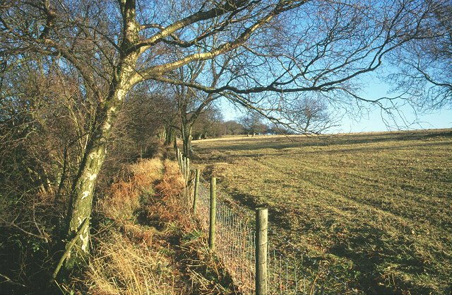
Cave Wood is a picturesque forest located in the county of Herefordshire, England. Situated near the hamlet of Woolhope, the wood covers an area of approximately 30 acres and is renowned for its natural beauty and tranquil atmosphere.

The wood is predominantly made up of deciduous trees, including oak, beech, and ash, which create a dense canopy of foliage that provides shade and shelter to a variety of flora and fauna. The forest floor is adorned with a carpet of vibrant wildflowers, including bluebells and primroses, adding splashes of color to the lush green surroundings.

Cave Wood is intersected by several footpaths and trails, allowing visitors to explore its diverse landscapes and discover hidden gems along the way. One of the highlights of the wood is a small cave, from which it takes its name. This natural limestone cave is formed by ancient geological processes and adds an element of mystique to the woodland experience.

The wood is a haven for wildlife, with numerous species calling it home. Visitors may spot squirrels scurrying among the treetops, while birdwatchers can observe a variety of avian species, including woodpeckers and warblers. The wood is also home to a diverse range of insects, adding to its ecological significance.

Cave Wood offers a peaceful retreat for nature enthusiasts, providing opportunities for walking, wildlife observation, and photography. The tranquil ambiance and natural beauty make it an ideal destination for those seeking solace in the heart of Herefordshire's countryside.

If you have any feedback on the listing, please let us know in the comments section below.

Cave Wood Images

Images are sourced within 2km of 52.22709/-3.0087282 or Grid Reference SO3159. Thanks to Geograph Open Source API. All images are credited.

On the Mortimer Trail - eastern shoulder of Rushoak Hill
Little Brampton Scar Above the scarp slopes on the long Silurian limestone ridge running from the Severn to the Wye. The plateau and dip slopes are agricultural, the scarp, north facing is wooded. Sometimes there were common grazings on the scarp slopes, but these have often reverted to woodland, a process visible at Byton SO3763 and Yatton Commons. SO4366. A footpath is squeezed between the fence and the wood.
Little Brampton Scar
Above the scarp slopes on the long Silurian limestone ridge running from the Severn to the Wye. The plateau and dip slopes are agricultural, the scarp, north facing is wooded. Sometimes there were common grazings on the scarp slopes, but these have often reverted to woodland, a process visible at Byton SO3763 and Yatton Commons. SO4366. A footpath is squeezed between the fence and the wood.
On the Mortimer Trail near Stocking Wood
Barn by the Mortimer Trail The trail goes down the track to the left of the old barn.
Barn by the Mortimer Trail
The trail goes down the track to the left of the old barn.
Trig points. Trig point on Little Brampton Scar set just off the main path of the Mortimer Trail.
Trig points.
Trig point on Little Brampton Scar set just off the main path of the Mortimer Trail.
Big Teepee, Titley
Big Teepee, Titley
The lane to Green Lane Farm
Trig Point at Brampton Scar near Kington There is fairly easy access to this trig point from the Mortimer Trail by taking a route to the eastern side of the old quarry workings and doesn't require crossing any fences.
Trig Point at Brampton Scar near Kington
There is fairly easy access to this trig point from the Mortimer Trail by taking a route to the eastern side of the old quarry workings and doesn't require crossing any fences.
On the Mortimer Trail at Little Brampton Wood above Titley
The Stagg Inn Titley The only pub in the UK with a Michelin Star
The Stagg Inn Titley
The only pub in the UK with a Michelin Star
Bank Farm seen from the Mortimer Trail
The B4355 leaving Titley This road leads to Kington.
The B4355 leaving Titley
This road leads to Kington.
Titley Junction This former station is being developed as a private railway centre. It once stood at the junction of four minor rail lines, from New Radnor, Leominster, Presteign and Earsdisley.
Titley Junction
This former station is being developed as a private railway centre. It once stood at the junction of four minor rail lines, from New Radnor, Leominster, Presteign and Earsdisley.
The River Arrow, near Titley In full flood, looking east.
The River Arrow, near Titley
In full flood, looking east.
Arable land in West Herefordshire Rolling countryside to the north-east of Kington near Rushock.
Arable land in West Herefordshire
Rolling countryside to the north-east of Kington near Rushock.
Woodland and pasture The coniferous Cave Wood alongside sheep pasture near Golden Bank, Rushock, Herefordshire.
Woodland and pasture
The coniferous Cave Wood alongside sheep pasture near Golden Bank, Rushock, Herefordshire.
Scene near Kennel Cottage A spot well off the beaten track amongst the pasture and woodland of the Marches country of Herefordshire.
Scene near Kennel Cottage
A spot well off the beaten track amongst the pasture and woodland of the Marches country of Herefordshire.
Black-faced Sheep Clustering around a feeder in pastures north of Rushock.
Black-faced Sheep
Clustering around a feeder in pastures north of Rushock.
Show me another place!

Cave Wood is located at Grid Ref: SO3159 (Lat: 52.22709, Lng: -3.0087282)

Unitary Authority: County of Herefordshire

Police Authority: West Mercia

What 3 Words

///grain.community.happy. Near Kington, Herefordshire

Related Wikis

Rushock, Herefordshire

Rushock is a small village in Herefordshire, England. It lies about 1 mile north-east of Kington. The population of the civil parish was 131 at the 2011...

Titley Pool

Titley Pool is a lake in Herefordshire, England. It is situated at Titley, 3 kilometres (1.9 mi) north west of the town of Kington. It is a naturally...
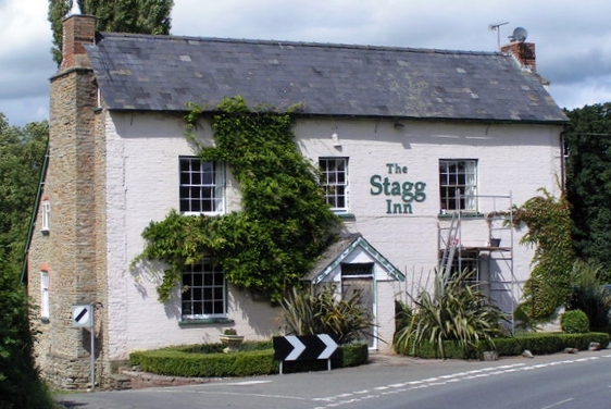
The Stagg Inn

The Stagg Inn is a restaurant located in Titley, Herefordshire, England. As of 2015, the restaurant holds one star in the Michelin Guide. The Stagg was...

Titley, Herefordshire

Titley is a village and civil parish in Herefordshire, England. It lies on the B4355 between Kington and Presteigne. In the 2001 census the parish had...

Nearby Amenities

Located within 500m of 52.22709,-3.0087282
Information: guidepost
Tourism: information
Lat/Long: 52.22561/-3.0108665
Power: pole
Lat/Long: 52.2247238/-3.0055439
Power: pole
Lat/Long: 52.2263618/-3.0053347
Power: pole
Lat/Long: 52.2281132/-3.005147
Power: pole
Lat/Long: 52.2298645/-3.0049163
Barrier: stile
Lat/Long: 52.2285977/-3.0102652
Barrier: swing_gate
Lat/Long: 52.2302783/-3.0061627
Barrier: swing_gate
Lat/Long: 52.2305822/-3.0059095
Barrier: swing_gate
Lat/Long: 52.2307424/-3.0058032
Barrier: stile
Lat/Long: 52.2285978/-3.0105347
Barrier: swing_gate
Lat/Long: 52.2285271/-3.0126115
Information: guidepost
Tourism: information
Lat/Long: 52.2284869/-3.0126925
Barrier: stile
Material: wood
Stile: stepover
Lat/Long: 52.2294562/-3.0127056
Ford: yes
Lat/Long: 52.2285482/-3.0124429
Information: route_marker
Tourism: information
Lat/Long: 52.2280789/-3.0133031
The data included in this document is from www.openstreetmap.org. The data is made available under ODbL.

Have you been to Cave Wood?

Leave your review of Cave Wood below (or comments, questions and feedback).