Abercraf

Settlement in Brecknockshire

Wales

Abercraf

OS Trig point at Cribarth Number on flush bracket is S2024
OS Trig point at Cribarth Credit: Janine Forbes

Abercraf is a small village located in the historic county of Brecknockshire, Wales. It lies on the southern edge of the Brecon Beacons National Park, nestled amidst the picturesque landscapes of the upper Swansea Valley. The village is situated approximately 16 miles north of Swansea and 14 miles south of Brecon.

Known for its natural beauty, Abercraf offers visitors a tranquil retreat with its stunning surroundings. The village is surrounded by rolling hills, lush green meadows, and dense forests, making it a popular destination for outdoor enthusiasts and nature lovers. The nearby rivers, including the River Tawe, provide opportunities for fishing and canoeing.

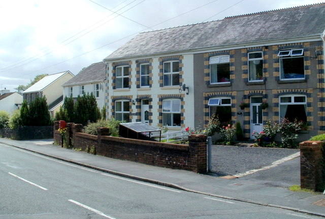
Historically, Abercraf was a mining village, with its economy centered around the coal industry. The remains of old collieries can still be seen in the area, serving as a reminder of the village's industrial past. Today, Abercraf has transitioned into a more tourism-based economy, with several charming bed and breakfasts, holiday cottages, and local shops catering to visitors.

For those interested in history, Abercraf offers a glimpse into the region's past. The village is home to the Abercraf War Memorial, honoring those who lost their lives during the First and Second World Wars. Additionally, the nearby Craig-y-Nos Castle, once the home of opera singer Adelina Patti, is a popular attraction for its stunning architecture and beautiful grounds.

Overall, Abercraf is a peaceful village that combines natural beauty with a rich history, making it an ideal destination for those seeking a serene escape in the heart of Brecknockshire.

If you have any feedback on the listing, please let us know in the comments section below.

Abercraf Images

Images are sourced within 2km of 51.802123/-3.712778 or Grid Reference SN8212. Thanks to Geograph Open Source API. All images are credited.

OS Trig point at Cribarth Number on flush bracket is S2024
OS Trig point at Cribarth
Number on flush bracket is S2024
Limestone with chert banding Group: Carboniferous Limestone, Formation: Upper Limestone. The chert here defines the bedding planes as they were deposited from a siliceous ooze at the same time as the limestone. The presence of chert lenses in joints does infer that some at least was post depositional.
Limestone with chert banding
Group: Carboniferous Limestone, Formation: Upper Limestone. The chert here defines the bedding planes as they were deposited from a siliceous ooze at the same time as the limestone. The presence of chert lenses in joints does infer that some at least was post depositional.
Swallow (or Sink) Holes Indicative of limestone areas. The limestone is eroded by water and underground cave systems may form causing collapse at the surface (collapsed swallow holes). These swallow holes are as yet just depressions in the surface.
Swallow (or Sink) Holes
Indicative of limestone areas. The limestone is eroded by water and underground cave systems may form causing collapse at the surface (collapsed swallow holes). These swallow holes are as yet just depressions in the surface.
The Sleeping Giant Cribarth viewed from the A4067 at SN804120.
From this angle the hill resembles the left profile of the head and chest of a man on his back - hence "Sleeping Giant".
The Sleeping Giant
Cribarth viewed from the A4067 at SN804120. From this angle the hill resembles the left profile of the head and chest of a man on his back - hence "Sleeping Giant".
Church outside Abercraf This church is right on the side of the A4067 north out of Abercraf.
Church outside Abercraf
This church is right on the side of the A4067 north out of Abercraf.
Bridge over the river Tawe west of Abercraf This bridge joins right on to the main A4067 road. I would have said it was a wide footbridge, but the houses and cars on the other side, maybe not.
Bridge over the river Tawe west of Abercraf
This bridge joins right on to the main A4067 road. I would have said it was a wide footbridge, but the houses and cars on the other side, maybe not.
Abercraf ... ... the very popular Abercrave Inn.
Abercraf ...
... the very popular Abercrave Inn.
Stile at crossing of public footpaths at Pen-cribarth
Ruin of old farmhouse at Pen-cribarth
Ruin of Drovers Inn Ruin of Drovers Inn on a drovers road. Sheep and Geese were kept in a walled enclosure whilst drovers overnighted in the inn.
Ruin of Drovers Inn
Ruin of Drovers Inn on a drovers road. Sheep and Geese were kept in a walled enclosure whilst drovers overnighted in the inn.
Part of walled enclosure around ruined drovers inn at Cribarth
Pant y Garreg Fawr This basin in the limestone country just west of Cribarth may be the largest natural depression in the whole of South Wales.  On the 25K map it is defined by 3 concentric ring contours, though curiously none are shown on the 50K map.  At least one of the smaller swallow holes in the floor of the larger depression extends downwards as a shaft.
Pant y Garreg Fawr
This basin in the limestone country just west of Cribarth may be the largest natural depression in the whole of South Wales. On the 25K map it is defined by 3 concentric ring contours, though curiously none are shown on the 50K map. At least one of the smaller swallow holes in the floor of the larger depression extends downwards as a shaft.
Field Gate Gate leading to field on farm
Field Gate
Gate leading to field on farm
The old curved track The line of the former Neath & Brecon Railway has lain quiet for many years though there are plans to revive it as part of the Sustrans national cycle network.
The old curved track
The line of the former Neath & Brecon Railway has lain quiet for many years though there are plans to revive it as part of the Sustrans national cycle network.
The old bridge over the Afon Tawe The bridge carrying the old road over the waters of the Tawe was abandoned to walkers and pushbikes when the A4067 was realigned.
The old bridge over the Afon Tawe
The bridge carrying the old road over the waters of the Tawe was abandoned to walkers and pushbikes when the A4067 was realigned.
Afon Tawe from the Abercraf bypass bridge The bypass built in 1970 to take traffic out of the village, crosses the river twice.  This lower bridge provides views onto a deep-flowing river running over dipping rock slabs.
Afon Tawe from the Abercraf bypass bridge
The bypass built in 1970 to take traffic out of the village, crosses the river twice. This lower bridge provides views onto a deep-flowing river running over dipping rock slabs.
Road to the Sleeping Giant A view along the section of the A4067 which bypasses Cae'r-Lan.  This affords the best view of the Sleeping Giant - the profile of Cribarth as seen from the south-west.
Road to the Sleeping Giant
A view along the section of the A4067 which bypasses Cae'r-Lan. This affords the best view of the Sleeping Giant - the profile of Cribarth as seen from the south-west.
Cribarth, Ynyswen A housing estate north of the A4067 in the upper Tawe Valley.
Cribarth, Ynyswen
A housing estate north of the A4067 in the upper Tawe Valley.
Show me another place!

Abercraf is located at Grid Ref: SN8212 (Lat: 51.802123, Lng: -3.712778)

Unitary Authority: Powys

Police Authority: Dyfed Powys

Also known as: Abercrave, Aber-craf

What 3 Words

///expires.moon.dignify. Near Seven Sisters, Neath Port Talbot

Related Wikis

Abercraf

Abercrâf or Abercrave is a village in Powys, Wales, in the community of Ystradgynlais and within the historic boundaries of the county of Brecknockshire...

Abercrave railway station

Abercrave railway station was a railway station that served the village of Abercraf in the traditional county of Brecknockshire, Wales. Opened in 1869...

Caehopkin

Caehopkin (Welsh: Caehopcyn) is a village in Powys, Wales. It lies between Abercraf and Coelbren in the Swansea Valley on the border of the Brecon Beacons...

Nant Llech

The Nant Llech is a minor river in Powys, Wales and which lies wholly within the Brecon Beacons National Park. The name means 'slab stream', presumably...
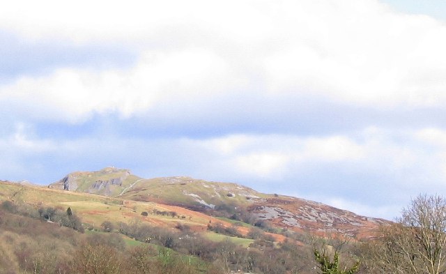
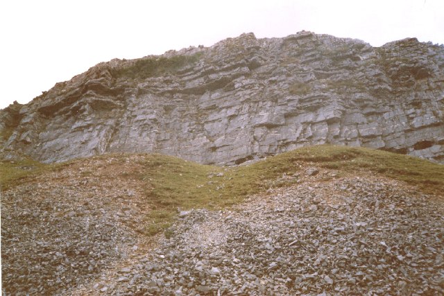
Cribarth

Cribarth, sometimes referred to as the Sleeping Giant, is a hill in the Brecon Beacons National Park, Powys, Wales, in the traditional county of Brecknockshire...

Wales Ape and Monkey Sanctuary

Wales Ape and Monkey Sanctuary is an animal sanctuary between Caehopkin and Abercraf in Powys, Wales. It became the Wales Ape & Monkey Sanctuary in December...
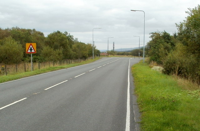
A4221 road

The A4221 is an A road which links Banwen with Abercraf in Wales. == Route == The roads begins just south of Abercraf at the junction with the A4067....

Pen-y-cae, Powys

Pen-y-cae is a village in Powys, Wales in the Brecon Beacons National Park between Abercraf and Craig-y-Nos Castle, in the community of Tawe-Uchaf. The...

Nearby Amenities

Located within 500m of 51.802123,-3.712778
Mini Roundabout
Source: Bing
Lat/Long: 51.799791/-3.7172566
Give Way
Direction: forward
Lat/Long: 51.8018509/-3.7072972
Abercraf
Name Cy: Aber-craf
Place: village
Wikidata: Q3402341
Lat/Long: 51.8005881/-3.7153943
Crossing
Lat/Long: 51.7999958/-3.7172776
Fire Station
Abercraf Fire and Rescue
Lat/Long: 51.8006913/-3.7169592
Place Of Worship
Capel Bryn Seion
Denomination: Annibynwyr
Name En: Bryn Seion Chapel
Religion: christian
Lat/Long: 51.8008903/-3.7137191
Barrier: stile
Foot: yes
Lat/Long: 51.8058648/-3.7107603
Barrier: stile
Foot: yes
Lat/Long: 51.8033455/-3.7134721
Pub
Abercrave Inn
Addr Postcode: SA9 1XS
Addr Street: Heol Tawe
Ale: yes
Food: yes
Source Postcode: FHRS Open Data
Source Postcode Url: http://ratings.food.gov.uk/business/en-GB/201311
Wikidata: Q80585126
Lat/Long: 51.8020742/-3.7057713
Pub
Copper Beach
Lat/Long: 51.8020458/-3.7068996
Post Office
Abercrave Post Office
Addr City: Swansea
Addr Country: GB
Addr Housenumber: 14
Addr Postcode: SA9 1XP
Addr Street: Heol Tawe
Brand: Post Office
Brand Wikidata: Q1783168
Fixme Addr 3: Abercrave
Opening Hours: Mo 09:00-14:00; Tu-Th 09:00-13:00
Ref Pol Id: 2901
Website: https://www.postoffice.co.uk/branch-finder/1516426/abercrave
Lat/Long: 51.7996264/-3.717567
School
Abercrave County Primary School
Lat/Long: 51.8004667/-3.7174568
Barrier: kissing_gate
Foot: yes
Lat/Long: 51.8017124/-3.7158971
Barrier: stile
Foot: yes
Lat/Long: 51.8049634/-3.7116932
Barrier: kissing_gate
Foot: yes
Lat/Long: 51.8023954/-3.7148762
Source: Bing
Waterway: weir
Lat/Long: 51.7999794/-3.7112744
Addr Housenumber: 22
Lat/Long: 51.7996866/-3.7172929
Bus Stop
Abercrave Inn
Bus: yes
Public Transport: platform
Lat/Long: 51.8019397/-3.7059338
Bus: yes
Public Transport: stop_position
Lat/Long: 51.8019816/-3.7059355
Post Box
Collection Times: Mo-Fr 16:30; Sa 09:30
Post Box Type: lamp
Ref: SA9 569
Royal Cypher: EIIR
Royal Cypher Wikidata: Q33102113
Lat/Long: 51.7996593/-3.7176343
Post Box
Collection Times: Mo-Fr 16:30; Sa 10:30
Post Box Type: lamp
Ref: SA9 568
Royal Cypher: EIIR
Royal Cypher Wikidata: Q33102113
Lat/Long: 51.8018934/-3.7069475
Direction: 165
Generator Method: photovoltaic
Generator Output Electricity: yes
Generator Solar Modules: 14
Generator Source: solar
Generator Type: solar_photovoltaic_panel
Location: roof
Power: generator
Lat/Long: 51.801416/-3.7186293
Direction: 165
Generator Method: photovoltaic
Generator Output Electricity: yes
Generator Solar Modules: 6
Generator Source: solar
Generator Type: solar_photovoltaic_panel
Location: roof
Power: generator
Lat/Long: 51.8014914/-3.7197451
Direction: S
Generator Method: photovoltaic
Generator Output Electricity: yes
Generator Solar Modules: 9
Generator Source: solar
Generator Type: solar_photovoltaic_panel
Location: ground
Power: generator
Lat/Long: 51.8018366/-3.7165986
Direction: SSE
Generator Method: photovoltaic
Generator Output Electricity: yes
Generator Solar Modules: 8
Generator Source: solar
Generator Type: solar_photovoltaic_panel
Location: roof
Power: generator
Lat/Long: 51.8010378/-3.7142265
Direction: SSE
Generator Method: photovoltaic
Generator Output Electricity: yes
Generator Solar Modules: 8
Generator Source: solar
Generator Type: solar_photovoltaic_panel
Location: roof
Power: generator
Lat/Long: 51.8010179/-3.7143217
Direction: 175
Generator Method: photovoltaic
Generator Output Electricity: yes
Generator Solar Modules: 16
Generator Source: solar
Generator Type: solar_photovoltaic_panel
Location: roof
Power: generator
Lat/Long: 51.8008661/-3.7116516
Direction: SSE
Generator Method: photovoltaic
Generator Output Electricity: yes
Generator Solar Modules: 16
Generator Source: solar
Generator Type: solar_photovoltaic_panel
Location: roof
Power: generator
Lat/Long: 51.7999076/-3.7165412
Direction: 80
Generator Method: photovoltaic
Generator Output Electricity: yes
Generator Solar Modules: 2
Generator Source: solar
Generator Type: solar_photovoltaic_panel
Location: roof
Power: generator
Lat/Long: 51.8056206/-3.7146402
Direction: 260
Generator Method: photovoltaic
Generator Output Electricity: yes
Generator Solar Modules: 14
Generator Source: solar
Generator Type: solar_photovoltaic_panel
Location: roof
Power: generator
Lat/Long: 51.8056221/-3.7146972
Direction: 80
Generator Method: photovoltaic
Generator Output Electricity: yes
Generator Solar Modules: 6
Generator Source: solar
Generator Type: solar_photovoltaic_panel
Location: roof
Power: generator
Lat/Long: 51.8056677/-3.7146489
Direction: 80
Generator Method: photovoltaic
Generator Output Electricity: yes
Generator Solar Modules: 4
Generator Source: solar
Generator Type: solar_photovoltaic_panel
Location: roof
Power: generator
Lat/Long: 51.8055848/-3.7146275
Power: pole
Lat/Long: 51.8005089/-3.7069125
Power: pole
Lat/Long: 51.800312/-3.708637
Power: pole
Lat/Long: 51.8001329/-3.7101734
Bus Stop
Abercrave Inn
Bus: yes
Public Transport: platform
Lat/Long: 51.8020118/-3.7058855
Bus Stop
Abercrave, Bryn Seion
Bus: yes
Public Transport: platform
Lat/Long: 51.8007906/-3.7126896
Bus Stop
Abercrave, Post Office
Bus: yes
Naptan AtcoCode: 5610WDB23415
Naptan NaptanCode: powmawp
Public Transport: platform
Lat/Long: 51.7996727/-3.7180205
Give Way
Direction: forward
Lat/Long: 51.7996005/-3.7184335
Bus Stop
Abercrave, Post Office
Bus: yes
Public Transport: platform
Lat/Long: 51.799496/-3.7185811
Bus Stop
Abercrave, Pant-y-cwrt
Bus: yes
Naptan AtcoCode: 5610SRX16455
Naptan NaptanCode: powadjm
Public Transport: platform
Lat/Long: 51.8012733/-3.7102253
Bus Stop
Abercrave, Pant-y-cwrt
Bus: yes
Public Transport: platform
Lat/Long: 51.8011717/-3.7103748
Bus Stop
Abercrave, Bryn Seion
Bus: yes
Naptan AtcoCode: 5610WBD48414
Naptan NaptanCode: powpjgt
Public Transport: platform
Lat/Long: 51.8009644/-3.7121169
The data included in this document is from www.openstreetmap.org. The data is made available under ODbL.

Have you been to Abercraf?

Leave your review of Abercraf below (or comments, questions and feedback).