Sharphayne Coppice

Wood, Forest in Devon East Devon

England

Sharphayne Coppice

Downhaye, NW of Colyton, Devon View across farmland and the Axe Valley.
Downhaye, NW of Colyton, Devon Credit: Stuart Buchan

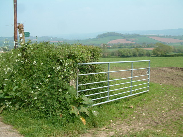
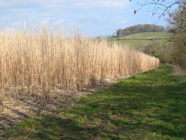
Located in the county of Devon, England, Sharphayne Coppice is a picturesque woodland area that spans across a vast expanse of approximately 200 acres. Situated in the heart of the countryside, this forested haven is known for its rich biodiversity and serene ambiance. The coppice, which refers to a managed woodland where trees are periodically cut to encourage new growth, is primarily composed of native trees such as oak, beech, ash, and hazel.

Sharphayne Coppice offers a tranquil retreat for nature enthusiasts and outdoor enthusiasts alike. The forest boasts a network of well-maintained footpaths and trails that wind through the enchanting woodlands, providing visitors with ample opportunities for leisurely walks, hiking, and exploring. The diverse flora and fauna found within the coppice further enhance its appeal, making it a haven for wildlife enthusiasts and birdwatchers.

The forest is home to a variety of animal species, including deer, foxes, badgers, and a plethora of bird species, such as woodpeckers, owls, and various songbirds. The vibrant array of wildflowers that bloom throughout the seasons adds a touch of color and beauty to the landscape.

Sharphayne Coppice also holds historical significance, as it has been in existence for centuries. The wood has been carefully managed throughout its history, with sustainable practices ensuring its preservation for future generations to enjoy. Additionally, the coppice has been utilized for traditional crafts such as charcoal making and woodcraft, keeping age-old traditions alive.

Overall, with its idyllic setting, diverse wildlife, and historical importance, Sharphayne Coppice provides a serene escape from the hustle and bustle of everyday life, allowing visitors to immerse themselves in the beauty of nature.

If you have any feedback on the listing, please let us know in the comments section below.

Sharphayne Coppice Images

Images are sourced within 2km of 50.751211/-3.0975391 or Grid Reference SY2295. Thanks to Geograph Open Source API. All images are credited.

Downhaye, NW of Colyton, Devon View across farmland and the Axe Valley.
Downhaye, NW of Colyton, Devon
View across farmland and the Axe Valley.
Kissing Gate and Public Footpath This photo was taken by the bridge over the River Col near Road Pitt Farm.
Kissing Gate and Public Footpath
This photo was taken by the bridge over the River Col near Road Pitt Farm.
Colyton: in the Coly valley Looking north towards Cadhayne
Colyton: in the Coly valley
Looking north towards Cadhayne
Colyton: in the Coly valley Looking north west near Ratshole Gate
Colyton: in the Coly valley
Looking north west near Ratshole Gate
Colyton: stream near Bolshayne A tributary of the Coly seen from Southleigh Road. Looking south-south-west
Colyton: stream near Bolshayne
A tributary of the Coly seen from Southleigh Road. Looking south-south-west
Colyton: towards Jobbleshayes Farm Looking south-south-east from the Southleigh Road. The Forestry Commission’s Morganhayes plantation stands on the hill above.
Colyton: towards Jobbleshayes Farm
Looking south-south-east from the Southleigh Road. The Forestry Commission’s Morganhayes plantation stands on the hill above.
Peering out from Downhayne Brake View out over the Umborne Valley towards Colcombe Wood with the Axe Valley beyond
Peering out from Downhayne Brake
View out over the Umborne Valley towards Colcombe Wood with the Axe Valley beyond
Farmland View The Cottages at Three Sycamores Cross with Colcombe Wood in the background
Farmland View
The Cottages at Three Sycamores Cross with Colcombe Wood in the background
Miscanthus Field of Miscanthus ready for harvesting, with Colcombe wood in background
Miscanthus
Field of Miscanthus ready for harvesting, with Colcombe wood in background
Bluebells near Carswells Moor These drifts are in a small wood that runs up a valley beside the green lane from Lawdeshayne to Crookham Cross.
Bluebells near Carswells Moor
These drifts are in a small wood that runs up a valley beside the green lane from Lawdeshayne to Crookham Cross.
Cottage near Rockerhayne The lane from Rockerhayne Cross down to the Offwell Brook passes this C17 cottage, which is described at <span class="nowrap"><a title="http://list.english-heritage.org.uk/resultsingle.aspx?uid=1098536&searchtype=mapsearch" rel="nofollow ugc noopener" href="http://list.english-heritage.org.uk/resultsingle.aspx?uid=1098536&searchtype=mapsearch">Link</a><img style="margin-left:2px;" alt="External link" title="External link - shift click to open in new window" src="https://s1.geograph.org.uk/img/external.png" width="10" height="10"/></span> .
Cottage near Rockerhayne
The lane from Rockerhayne Cross down to the Offwell Brook passes this C17 cottage, which is described at LinkExternal link .
Field in the Coly valley Looking down the valley from the Bonehayne and Purlbridge Road. Belts of woodland hide the river.
Field in the Coly valley
Looking down the valley from the Bonehayne and Purlbridge Road. Belts of woodland hide the river.
Bonehayne A large farm in the Coly valley, seen from the edge of Bonehayne Covert. Ball Hill rises behind.
Bonehayne
A large farm in the Coly valley, seen from the edge of Bonehayne Covert. Ball Hill rises behind.
Hamberhayne Farm The farm seen from the green lane running along the foot of Hamberhayne Copse. Behind is Knowle Hill.
Hamberhayne Farm
The farm seen from the green lane running along the foot of Hamberhayne Copse. Behind is Knowle Hill.
Overgrown farm building, Crookham This is at the head of the woods on Carswells Moor; taken from the green lane which climbs to Crookham Cross.
Overgrown farm building, Crookham
This is at the head of the woods on Carswells Moor; taken from the green lane which climbs to Crookham Cross.
Purlbridge Farm A farm in the Coly valley that seems to have been overlooked by the passage of time. On Purlbridge Road approaching Bonehayne.
Purlbridge Farm
A farm in the Coly valley that seems to have been overlooked by the passage of time. On Purlbridge Road approaching Bonehayne.
Hardy's Hill Cottage A cottage on the edge of the Coly valley, seen from the Bonehayne and Purlbridge Road. Above it is Cottshayne Hill.
Hardy's Hill Cottage
A cottage on the edge of the Coly valley, seen from the Bonehayne and Purlbridge Road. Above it is Cottshayne Hill.
Valley of the Coly View from the road between Barittshays and Lawdeshayne across the valley of the River Coly . In the distance is the hill of Great Pen.
Valley of the Coly
View from the road between Barittshays and Lawdeshayne across the valley of the River Coly . In the distance is the hill of Great Pen.
Show me another place!

Sharphayne Coppice is located at Grid Ref: SY2295 (Lat: 50.751211, Lng: -3.0975391)

Administrative County: Devon

District: East Devon

Police Authority: Devon and Cornwall

What 3 Words

///candidate.surfacing.flaked. Near Colyton, Devon

Related Wikis

Bolshayne Fen

Bolshayne Fen (grid reference SY222938) is a wetland in southeast Devon, England. It has an area of 1.62 hectares. The site was designated as a Site of...

Colcombe Castle

Colcombe Castle was a castle or fortified house situated about a 0.5 mi (0.80 km) north of the town of Colyton in East Devon. It was a seat of the Courtenay...

Great House, Colyton

Great House on South Street in the town of Colyton, Devon, is the remnant of an historic Elizabethan mansion house built by the Yonge family, originally...

Umborne Brook

Umbourne Brook is a watercourse in Devon, England. In rises south-east of Upottery and runs past the villages of Widworthy and Wilmington then joins the...

Nearby Amenities

Located within 500m of 50.751211,-3.0975391
Post Box
Lat/Long: 50.7485642/-3.1010285
The data included in this document is from www.openstreetmap.org. The data is made available under ODbL.

Have you been to Sharphayne Coppice?

Leave your review of Sharphayne Coppice below (or comments, questions and feedback).