Hallthwaites Wood

Wood, Forest in Cumberland Copeland

England

Hallthwaites Wood

A595 at Buckman Brow
A595 at Buckman Brow Credit: Colin Pyle

Hallthwaites Wood is a scenic and historic woodland located in the county of Cumberland, England. Situated near the village of Hallthwaites, the wood covers an area of approximately 50 acres and is known for its diverse flora and fauna.

The wood is primarily composed of native broadleaf trees, including oak, ash, birch, and beech, which form a dense canopy providing shelter and habitat for a wide range of wildlife. Throughout the wood, visitors can find a variety of plant species, such as bluebells, wild garlic, and wood anemones, creating a vibrant and colorful display during the spring and summer months.

The woodland is intersected by several footpaths and trails, offering visitors the opportunity to explore its natural beauty. These trails wind through the trees, providing stunning views of the surrounding countryside and glimpses of wildlife, including deer, squirrels, and a variety of bird species.

Hallthwaites Wood holds historical significance as well, with evidence of human activity dating back to the medieval period. Remnants of ancient earthworks and boundary walls can still be seen within the wood, providing a glimpse into its past. The wood has also been a popular location for recreational activities, such as picnicking, walking, and birdwatching.

Overall, Hallthwaites Wood is a picturesque and historically significant woodland, offering visitors a chance to immerse themselves in the natural beauty of Cumberland while exploring its rich history and diverse ecosystem.

If you have any feedback on the listing, please let us know in the comments section below.

Hallthwaites Wood Images

Images are sourced within 2km of 54.256619/-3.2553455 or Grid Reference SD1885. Thanks to Geograph Open Source API. All images are credited.

A595 at Buckman Brow
A5093 at The Green village boundary
A5093 at The Hill village boundary
The Punch Bowl Inn, The Green, Millom
Ordnance Survey Cut Mark This OS cut mark can be found adjacent to the letter box at Broadgate. It marks a point 107.274m above mean sea level.
Ordnance Survey Cut Mark
This OS cut mark can be found adjacent to the letter box at Broadgate. It marks a point 107.274m above mean sea level.
Ordnance Survey Cut Mark This OS cut mark can be found on Old Hall Cottage. It marks a point 39.156m above mean sea level.
Ordnance Survey Cut Mark
This OS cut mark can be found on Old Hall Cottage. It marks a point 39.156m above mean sea level.
Ordnance Survey Cut Mark This OS cut mark can be found on Briar Dene. It marks a point 19.020m above mean sea level.
Ordnance Survey Cut Mark
This OS cut mark can be found on Briar Dene. It marks a point 19.020m above mean sea level.
SRPS Cumbrian Coast Railtour 2018 : Green Road Station
SRPS Cumbrian Coast Railtour 2018 : Signal Post Before Duddon Viaduct
SRPS Cumbrian Coast Railtour 2018 : Approaching Duddon Viaduct
Boundary Stone Toppled and damaged, over stream, south side of the A595.
Boundary Stone
Toppled and damaged, over stream, south side of the A595.
Ordnance Survey Cut Mark This OS cut mark can be found on the gatepost south side of the road. It marks a point 59.576m above mean sea level.
Ordnance Survey Cut Mark
This OS cut mark can be found on the gatepost south side of the road. It marks a point 59.576m above mean sea level.
Ordnance Survey Cut Mark This OS cut mark can be found on the large boulder in the wall SE side of the road. It marks a point 99.048m above mean sea level.
Ordnance Survey Cut Mark
This OS cut mark can be found on the large boulder in the wall SE side of the road. It marks a point 99.048m above mean sea level.
Ordnance Survey OSBM Bolt This OS Bolt can be found on the large boulder at the side of the barn at Low Broadgate. It marks a point 81.764m above mean sea level.
Ordnance Survey OSBM Bolt
This OS Bolt can be found on the large boulder at the side of the barn at Low Broadgate. It marks a point 81.764m above mean sea level.
Ordnance Survey Cut Mark This OS cut mark can be found on the wall NW side of the road. It marks a point 98.207m above mean sea level.
Ordnance Survey Cut Mark
This OS cut mark can be found on the wall NW side of the road. It marks a point 98.207m above mean sea level.
Ordnance Survey Cut Mark This OS cut mark can be found on the brick building at Waltham Nursery. It marks a point 5.925m above mean sea level.
Ordnance Survey Cut Mark
This OS cut mark can be found on the brick building at Waltham Nursery. It marks a point 5.925m above mean sea level.
Ordnance Survey Cut Mark This OS cut mark can be found on a gatepost SE side of the track. It marks a point 6.172m above mean sea level.
Ordnance Survey Cut Mark
This OS cut mark can be found on a gatepost SE side of the track. It marks a point 6.172m above mean sea level.
Ordnance Survey Flush Bracket (G3077) This OS Flush Bracket can be found on The Oaks. It marks a point 35.752m above mean sea level.
Ordnance Survey Flush Bracket (G3077)
This OS Flush Bracket can be found on The Oaks. It marks a point 35.752m above mean sea level.
Show me another place!

Hallthwaites Wood is located at Grid Ref: SD1885 (Lat: 54.256619, Lng: -3.2553455)

Administrative County: Cumbria

District: Copeland

Police Authority: Cumbria

What 3 Words

///sliders.readjust.spent. Near Millom, Cumbria

Related Wikis

Thwaites, Cumbria

Thwaites is a small village near Duddon Valley and on the edge of the Duddon Estuary in the Lake District National Park in the Borough of Copeland, Cumbria...

St Anne's Church, Thwaites

St Anne's Church is in the village of Thwaites, Cumbria, England. It is an active Anglican parish church in the deanery of Millom, the archdeaconry of...

Millom Without

Millom Without is a civil parish in the county of Cumbria, England. It had a population of 1,638 in 2001, decreasing to 859 at the 2011 Census. Millom...

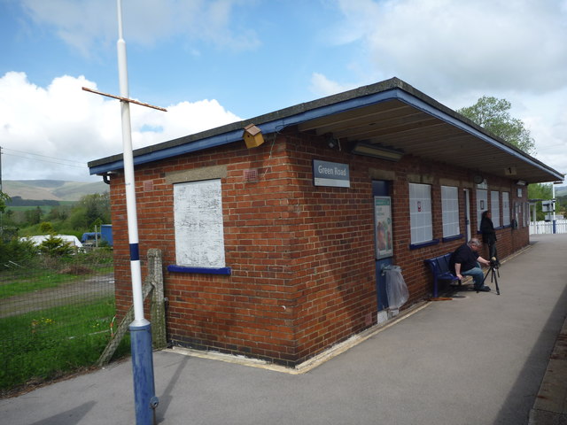
Green Road railway station

Green Road is a railway station on the Cumbrian Coast Line, which runs between Carlisle and Barrow-in-Furness. The station, situated 13+1⁄2 miles (22 km...

Nearby Amenities

Located within 500m of 54.256619,-3.2553455
Power: tower
Lat/Long: 54.2536523/-3.2503915
Barrier: stile
Lat/Long: 54.2572656/-3.255224
Barrier: stile
Lat/Long: 54.2574335/-3.2524996
Barrier: stile
Lat/Long: 54.26068/-3.2572356
Post Box
Post Box Type: lamp
Lat/Long: 54.257875/-3.2592547
Power: pole
Lat/Long: 54.2535946/-3.2591488
Power: pole
Lat/Long: 54.2541222/-3.2589635
Power: pole
Lat/Long: 54.2547512/-3.2587609
Power: pole
Lat/Long: 54.2555122/-3.2583672
Power: pole
Lat/Long: 54.2572235/-3.2578461
Power: pole
Lat/Long: 54.2581772/-3.2578403
Power: pole
Lat/Long: 54.2589955/-3.2577998
Power: pole
Lat/Long: 54.2590632/-3.2567114
Power: pole
Lat/Long: 54.2590564/-3.259693
Power: pole
Lat/Long: 54.2591443/-3.2556577
Power: pole
Lat/Long: 54.2592154/-3.2539035
Power: pole
Lat/Long: 54.2582888/-3.2506846
Material: wood
Power: pole
Lat/Long: 54.2591477/-3.2616266
Material: wood
Power: pole
Lat/Long: 54.2551284/-3.2621944
Material: wood
Power: pole
Lat/Long: 54.2550244/-3.262439
Barrier: kissing_gate
Lat/Long: 54.2553935/-3.2621098
Power: pole
Lat/Long: 54.2575091/-3.2588399
Fire Hydrant
Emergency: fire_hydrant
Fire Hydrant Position: lane
Fire Hydrant Type: underground
Lat/Long: 54.257473/-3.2587153
Power: pole
Lat/Long: 54.2574139/-3.2583819
Power: pole
Lat/Long: 54.2572236/-3.2571756
Power: pole
Lat/Long: 54.2579126/-3.2602099
Power: pole
Lat/Long: 54.257864/-3.2592416
Power: pole
Lat/Long: 54.2580755/-3.2608053
Power: pole
Lat/Long: 54.2591778/-3.250739
Power: pole
Lat/Long: 54.2593818/-3.2517356
Power: pole
Lat/Long: 54.2598639/-3.2508335
Power: pole
Lat/Long: 54.2605966/-3.2577978
Power: pole
Lat/Long: 54.259767/-3.2577937
Hallthwaites
Place: village
Source: OS_OpenData_StreetView
Lat/Long: 54.2580677/-3.2595921
Parking
Parking: layby
Lat/Long: 54.2584079/-3.2622024
The data included in this document is from www.openstreetmap.org. The data is made available under ODbL.

Have you been to Hallthwaites Wood?

Leave your review of Hallthwaites Wood below (or comments, questions and feedback).