Breakneck Copse

Wood, Forest in Somerset Somerset West and Taunton

England

Breakneck Copse

Wiveliscombe Without: bridleway at Oakhampton Farm Looking south east
Wiveliscombe Without: bridleway at Oakhampton Farm Credit: Martin Bodman

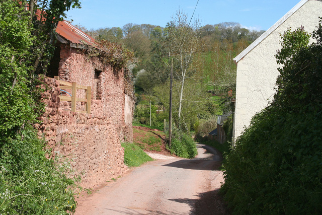
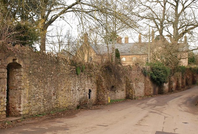
Breakneck Copse is a picturesque woodland located in Somerset, England. Situated in the southern part of the county, this enchanting forest covers an area of approximately 50 acres. Its name, Breakneck Copse, is believed to have originated from the steep and treacherous terrain that characterizes the woodland.

The copse is predominantly made up of a variety of deciduous trees, such as oak, beech, and ash. These towering trees create a dense canopy that provides a cool and serene atmosphere within the forest. The woodland floor is covered in a thick carpet of moss, ferns, and wildflowers, adding to the natural beauty of the area.

Breakneck Copse is home to a diverse range of wildlife. Bird enthusiasts can spot various species, including woodpeckers, owls, and warblers, among others. Squirrels, badgers, and foxes are also commonly sighted within the woodland. Additionally, the copse is known for its vibrant butterfly population, attracting nature lovers from far and wide.

The copse offers numerous walking trails, allowing visitors to explore its breathtaking surroundings. These well-maintained paths wind through the woodland, offering glimpses of tranquil streams and small ponds along the way. The copse is a popular destination for hikers, photographers, and nature enthusiasts who appreciate the serenity and beauty of this natural haven.

Breakneck Copse is easily accessible, with a nearby parking area and public transportation links. It provides a peaceful escape from the bustle of everyday life, offering visitors a chance to immerse themselves in the tranquility of nature.

If you have any feedback on the listing, please let us know in the comments section below.

Breakneck Copse Images

Images are sourced within 2km of 51.064777/-3.2665767 or Grid Reference ST1130. Thanks to Geograph Open Source API. All images are credited.

Wiveliscombe Without: bridleway at Oakhampton Farm Looking south east
Wiveliscombe Without: bridleway at Oakhampton Farm
Looking south east
White House above Ford
Pastures at Western Goulds View east of the B3188.
Pastures at Western Goulds
View east of the B3188.
Sheep pastures East of Oakhampton Farm to the north of Wiveliscombe.
Sheep pastures
East of Oakhampton Farm to the north of Wiveliscombe.
Gandstone Cross
Gandstone Cross
Pitsford Hill
Pitsford Hill
Road to Pitsford Hill
Field next to the B3188
B3188 heading south to Pitsford Hill
Brompton Ralph: Looking north on the B3188 Near Courtland Farm, with Willett Hill ahead
Brompton Ralph: Looking north on the B3188
Near Courtland Farm, with Willett Hill ahead
View west of Pitsford Hill Looking up a small valley from the B3188.
View west of Pitsford Hill
Looking up a small valley from the B3188.
Gated track Typical countryside view for this area.
Gated track
Typical countryside view for this area.
B3188 near Pitsford Hill The B road north of Pitsford Hill, with a tractor approaching Gandstone Cross.
B3188 near Pitsford Hill
The B road north of Pitsford Hill, with a tractor approaching Gandstone Cross.
Fitzhead: St James the Great In 1791 the church was dedicated to St Mary Magdalene. Until 1755 this was a daughter church or chapelry of Wiveliscombe; it was rebuilt in 1849. A new north aisle was added in 1887. The west tower survives from the earlier church and is 15th century
Fitzhead: St James the Great
In 1791 the church was dedicated to St Mary Magdalene. Until 1755 this was a daughter church or chapelry of Wiveliscombe; it was rebuilt in 1849. A new north aisle was added in 1887. The west tower survives from the earlier church and is 15th century
Fitzhead: St James the Great The 15th century west tower, the survivor from the medieval church
Fitzhead: St James the Great
The 15th century west tower, the survivor from the medieval church
Fitzhead: north west from the village Landscape with woods and fields. Looking north towards the Quantocks
Fitzhead: north west from the village
Landscape with woods and fields. Looking north towards the Quantocks
Lydeard St Lawrence: Chapel Leigh Chapel Leigh is a hamlet consisting of two farms and a number of cottages. Looking east-north-east
Lydeard St Lawrence: Chapel Leigh
Chapel Leigh is a hamlet consisting of two farms and a number of cottages. Looking east-north-east
Fitzhead: limekiln near Burrow Hill Farm Looking south
Fitzhead: limekiln near Burrow Hill Farm
Looking south
Show me another place!

Breakneck Copse is located at Grid Ref: ST1130 (Lat: 51.064777, Lng: -3.2665767)

Administrative County: Somerset

District: Somerset West and Taunton

Police Authority: Avon and Somerset

What 3 Words

///newsprint.pounding.hoping. Near Wiveliscombe, Somerset

Related Wikis

Gaulden Manor

Gaulden Manor (also Gavelden or Gaveldene) is a Grade II* listed country house to the southeast of Tolland, Somerset, England. It is a double storied building...

Ruby Country

Ruby Country is the name given to the rural inland hinterland of north-west Devon, UK. It covers 45 parishes around the market towns of Holsworthy and...

Fitzhead

Fitzhead is a village and civil parish in Somerset, England, situated approximately 6 miles (9.7 km) north west of Taunton. The village has an estimated...

Fitzhead Court and The Manor

Fitzhead Court and The Manor in Fitzhead, Somerset, England was built in the late 16th century and has now been split into two buildings. It is a Grade...

Nearby Amenities

Located within 500m of 51.064777,-3.2665767
Hoccombe Ford
Junction: yes
Lat/Long: 51.0632342/-3.2675
Barrier: stile
Bicycle: no
Foot: yes
Material: wood
Stile: stepover
Lat/Long: 51.0680236/-3.2621183
Barrier: stile
Bicycle: no
Foot: yes
Material: wood
Stile: stepover
Lat/Long: 51.0681988/-3.2640777
Brand: National Grid
Brand Wikidata: Q1465461
Material: wood
Operator: National Grid Electricity Distribution Plc
Operator Old: Western Power Distribution
Operator Wikidata: Q7988183
Owner: National Grid Electricity Distribution (South West) Plc
Owner Wikidata: Q114397866
Power: pole
Lat/Long: 51.0641606/-3.2726115
Brand: National Grid
Brand Wikidata: Q1465461
Material: wood
Operator: National Grid Electricity Distribution Plc
Operator Old: Western Power Distribution
Operator Wikidata: Q7988183
Owner: National Grid Electricity Distribution (South West) Plc
Owner Wikidata: Q114397866
Power: pole
Lat/Long: 51.0618125/-3.2666422
Brand: National Grid
Brand Wikidata: Q1465461
Material: wood
Operator: National Grid Electricity Distribution Plc
Operator Old: Western Power Distribution
Operator Wikidata: Q7988183
Owner: National Grid Electricity Distribution (South West) Plc
Owner Wikidata: Q114397866
Power: pole
Lat/Long: 51.0625289/-3.2654634
Brand: National Grid
Brand Wikidata: Q1465461
Material: wood
Operator: National Grid Electricity Distribution Plc
Operator Old: Western Power Distribution
Operator Wikidata: Q7988183
Owner: National Grid Electricity Distribution (South West) Plc
Owner Wikidata: Q114397866
Power: pole
Lat/Long: 51.0638024/-3.2638232
Brand: National Grid
Brand Wikidata: Q1465461
Material: wood
Operator: National Grid Electricity Distribution Plc
Operator Old: Western Power Distribution
Operator Wikidata: Q7988183
Owner: National Grid Electricity Distribution (South West) Plc
Owner Wikidata: Q114397866
Power: pole
Lat/Long: 51.0646031/-3.2628027
Brand: National Grid
Brand Wikidata: Q1465461
Material: wood
Operator: National Grid Electricity Distribution Plc
Operator Old: Western Power Distribution
Operator Wikidata: Q7988183
Owner: National Grid Electricity Distribution (South West) Plc
Owner Wikidata: Q114397866
Power: pole
Lat/Long: 51.0651867/-3.2620402
Brand: National Grid
Brand Wikidata: Q1465461
Material: wood
Operator: National Grid Electricity Distribution Plc
Operator Old: Western Power Distribution
Operator Wikidata: Q7988183
Owner: National Grid Electricity Distribution (South West) Plc
Owner Wikidata: Q114397866
Power: pole
Lat/Long: 51.0632445/-3.2645582
Brand: National Grid
Brand Wikidata: Q1465461
Material: wood
Operator: National Grid Electricity Distribution Plc
Operator Old: Western Power Distribution
Operator Wikidata: Q7988183
Owner: National Grid Electricity Distribution (South West) Plc
Owner Wikidata: Q114397866
Power: pole
Lat/Long: 51.0660063/-3.2609734
The data included in this document is from www.openstreetmap.org. The data is made available under ODbL.

Have you been to Breakneck Copse?

Leave your review of Breakneck Copse below (or comments, questions and feedback).