Alder Grove

Wood, Forest in Devon Mid Devon

England

Alder Grove

Ordnance Survey Cut Mark This OS cut mark can be found on the porch of All Saints Church. It marks a point 139.513m above mean sea level.
Ordnance Survey Cut Mark Credit: Adrian Dust

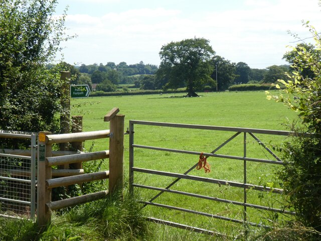
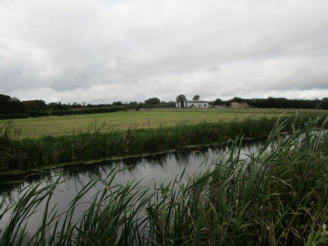
Alder Grove, located in the county of Devon, England, is a picturesque wood and forest area renowned for its natural beauty and diverse flora and fauna. Covering a vast expanse of land, this enchanting grove offers visitors a tranquil escape from the bustling city life.

The grove is predominantly made up of alder trees, which thrive in the moist and fertile soil of Devon. These trees, with their distinctive slender trunks and dark green leaves, create a dense canopy that filters the sunlight and adds to the overall serenity of the area. The grove is also home to a variety of other tree species, including oak, beech, and birch, which further enhance its natural charm.

Alder Grove is a haven for wildlife enthusiasts and nature lovers alike, as it provides a sanctuary for a wide range of animal species. Visitors can spot an array of bird species, such as woodpeckers, owls, and finches, as they flit between the branches. Squirrels, foxes, and deer are also commonly sighted, adding to the allure of this woodland paradise.

For those wishing to explore the grove, there are several well-maintained footpaths and trails that wind their way through the forest. These paths allow visitors to immerse themselves in the peacefulness of the grove, while also offering opportunities to discover hidden streams, vibrant wildflowers, and ancient ruins.

Alder Grove, Devon, truly is a natural gem that showcases the beauty of England's woodlands. Whether it be for a tranquil walk, birdwatching, or simply enjoying the serenity of nature, this enchanting grove offers something for everyone.

If you have any feedback on the listing, please let us know in the comments section below.

Alder Grove Images

Images are sourced within 2km of 50.948022/-3.3510773 or Grid Reference ST0517. Thanks to Geograph Open Source API. All images are credited.

Ordnance Survey Cut Mark This OS cut mark can be found on the porch of All Saints Church. It marks a point 139.513m above mean sea level.
Ordnance Survey Cut Mark
This OS cut mark can be found on the porch of All Saints Church. It marks a point 139.513m above mean sea level.
Ordnance Survey Cut Mark This OS cut mark can be found on the wall SE side of the road. It marks a point 127.349m above mean sea level.
Ordnance Survey Cut Mark
This OS cut mark can be found on the wall SE side of the road. It marks a point 127.349m above mean sea level.
Ordnance Survey Cut Mark This looks like an uncompleted OS cut mark about 5m NE of a completed mark. <a title="https://www.geograph.org.uk/photo/7687952" href="https://www.geograph.org.uk/photo/7687952">Link</a>
Ordnance Survey Cut Mark
This looks like an uncompleted OS cut mark about 5m NE of a completed mark. Link
Ordnance Survey Cut Mark This OS cut mark can be found on the wall NE side of the road. It marks a point 116.830m above mean sea level. <a title="https://www.geograph.org.uk/photo/7687951" href="https://www.geograph.org.uk/photo/7687951">Link</a>
Ordnance Survey Cut Mark
This OS cut mark can be found on the wall NE side of the road. It marks a point 116.830m above mean sea level. Link
Ordnance Survey Cut Mark This OS cut mark can be found on the east parapet of the bridge. It marks a point 119.247m above mean sea level.
Ordnance Survey Cut Mark
This OS cut mark can be found on the east parapet of the bridge. It marks a point 119.247m above mean sea level.
Stile between Ford and Holcombe Rogus
Minor road to Holcombe Rogus
Footpath to Black Lane, Holcombe Rogus
Gate at start of two footpaths, near Holcombe Rogus
Part of Holcombe Rogus primary school Above the window, the carved inscription reads "Holcombe Rogus Charity School"
Part of Holcombe Rogus primary school
Above the window, the carved inscription reads "Holcombe Rogus Charity School"
Westcott Bridge, Grand Western Canal
Grand Western Canal and Ley Barn
Black Bridge Carried a mineral railway serving Westleigh Quarry. Now carries a footpath.
The railway replaced a tramway in 1892.
Black Bridge
Carried a mineral railway serving Westleigh Quarry. Now carries a footpath. The railway replaced a tramway in 1892.
The Grand Western Canal at Great Fossend
Towpath alongside the Grand Western Canal
Burlescombe : Grand Western Canal Looking towards Fenacre Bridge.
Burlescombe : Grand Western Canal
Looking towards Fenacre Bridge.
Burlescombe : Grand Western Canal The canal heading through the countryside.
Burlescombe : Grand Western Canal
The canal heading through the countryside.
Holcombe Rogus : Holcombe Court The present grade I listed Tudor manor house known as Holcombe Court was built by Sir Roger Bluett c.1540 and was owned by the Bluett family until 1858 when the estate was sold to Rev. William Rayer.
Holcombe Rogus : Holcombe Court
The present grade I listed Tudor manor house known as Holcombe Court was built by Sir Roger Bluett c.1540 and was owned by the Bluett family until 1858 when the estate was sold to Rev. William Rayer.
Show me another place!

Alder Grove is located at Grid Ref: ST0517 (Lat: 50.948022, Lng: -3.3510773)

Administrative County: Devon

District: Mid Devon

Police Authority: Devon and Cornwall

What 3 Words

///bowls.windpipe.mashing. Near Sampford Peverell, Devon

Related Wikis

Canonsleigh Abbey

Canonsleigh Abbey was an Augustinian priory in the parish of Burlescombe, Devon. == History == It was founded in about 1170 by Walter de Claville, lord...

Holcombe Rogus

Holcombe Rogus is a village, civil parish and ecclesiastical parish in the English county of Devon. In 2001 the population of the parish was 503. ��2...

Manor of Holcombe Rogus

Holcombe Rogus is a historic manor in the parish of Holcombe Rogus in Devon, England. The present grade I listed Tudor manor house known as Holcombe Court...

Ayshford Chapel

Ayshford Chapel is a former private chapel in the village of Ayshford, in the parish of Burlescombe, Devon, England. It is recorded in the National Heritage...

Holbrook Garden

Holbrook Garden is a one hectare garden outside Sampford Peverell, Tiverton, Devon, with experimental naturalistic plantings creating differing habitats...

Hockworthy

Hockworthy is a village and civil parish in Devon, England. Its name is Old English and means "Hocca's enclosure". It has a church dedicated to St. Simon...

Burlescombe

Burlescombe (, bur-LES-kəm) is a village and civil parish in the Mid Devon district of Devon, England. The parish is surrounded, clockwise from the north...

Ayshford

Ayshford is a hamlet and historic manor in the parish of Burlescombe in the district of Mid-Devon, Devon, England. It was anciently the seat of the de...

Nearby Amenities

Located within 500m of 50.948022,-3.3510773
Durleymoor Cross
Junction: yes
Source: OS OpenData StreetView
Lat/Long: 50.9519535/-3.3507793
The data included in this document is from www.openstreetmap.org. The data is made available under ODbL.

Have you been to Alder Grove?

Leave your review of Alder Grove below (or comments, questions and feedback).