Annesley Woodhouse

Settlement in Nottinghamshire Ashfield

England

Annesley Woodhouse

Farm Track and Footpath close to the M1 Motorway Fields of barley are all that separate this rural view from the busy trunk road ahead.
Farm Track and Footpath close to the M1 Motorway Credit: Jonathan Clitheroe

Annesley Woodhouse is a small village located in the Ashfield district of Nottinghamshire, England. Situated approximately 12 miles north-west of Nottingham city centre, it is surrounded by picturesque countryside and rolling hills. The village has a population of around 2,000 residents.

Historically, Annesley Woodhouse was part of the coal mining industry that thrived in the region. Evidence of this can still be seen in the form of old mine shafts and disused colliery buildings. However, with the decline of the coal industry in the 1980s, the village has shifted towards a more residential focus.

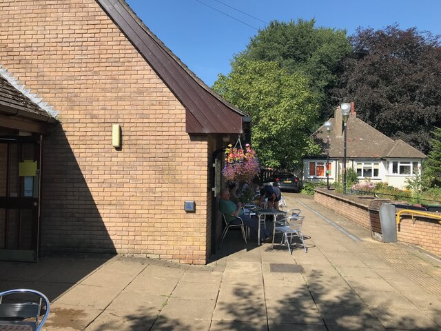
Annesley Woodhouse is known for its charming rural atmosphere and close-knit community. The village features a range of housing, from traditional stone cottages to more modern developments. It also boasts a number of amenities, including a primary school, a village hall, and a local pub, providing a sense of community and convenience for the residents.

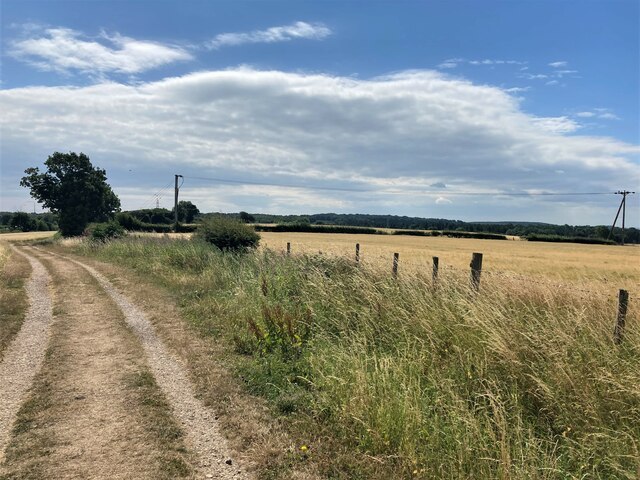
For nature lovers, the village is surrounded by beautiful countryside, with plenty of opportunities for walking, cycling, and exploring the nearby woodlands. Annesley Country Park, a former colliery site, has been transformed into a nature reserve and offers a tranquil escape for outdoor enthusiasts.

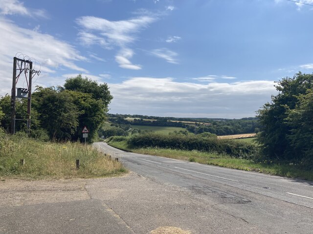
Transport links in Annesley Woodhouse are excellent, with easy access to major roads such as the M1 motorway and the A611. The nearby towns of Hucknall and Kirkby-in-Ashfield provide additional amenities and transport links, further enhancing the convenience of living in the village.

Overall, Annesley Woodhouse offers a peaceful and idyllic setting, making it an attractive place to live for those seeking a rural lifestyle while still being within reach of urban amenities.

If you have any feedback on the listing, please let us know in the comments section below.

Annesley Woodhouse Images

Images are sourced within 2km of 53.07615/-1.257494 or Grid Reference SK4953. Thanks to Geograph Open Source API. All images are credited.

Farm Track and Footpath close to the M1 Motorway Fields of barley are all that separate this rural view from the busy trunk road ahead.
Farm Track and Footpath close to the M1 Motorway
Fields of barley are all that separate this rural view from the busy trunk road ahead.
Salmon Lane Pictured from an embankment above the M1 at Leaside. Looking towards Annesley Woodhouse.
Salmon Lane
Pictured from an embankment above the M1 at Leaside. Looking towards Annesley Woodhouse.
Annesley Woodhouse Post Office Post Office and dwellings located on Forest Road.
Annesley Woodhouse Post Office
Post Office and dwellings located on Forest Road.
Co-op store on Skegby Road This has been built on the site of the former pub the General Havelock. Many pub buildings are converted to stores, but this one has been completely rebuilt.
Co-op store on Skegby Road
This has been built on the site of the former pub the General Havelock. Many pub buildings are converted to stores, but this one has been completely rebuilt.
Footpath by Sycamore Farm Leaving Annesley Woodhouse in the direction of the M1 motorway.
Footpath by Sycamore Farm
Leaving Annesley Woodhouse in the direction of the M1 motorway.
New housing in Annesley Woodhouse Constructed on an existing housing site.
New housing in Annesley Woodhouse
Constructed on an existing housing site.
Sherwood Dene A fairly new estate in Kirkby Woodhouse.
Sherwood Dene
A fairly new estate in Kirkby Woodhouse.
Green space on the edge of Kirkby Woodhouse Looking down into the valley of the River Erewash.
Green space on the edge of Kirkby Woodhouse
Looking down into the valley of the River Erewash.
Main Road, Kirkby Woodhouse The buildings here appear to be older than most in the locality.
Main Road, Kirkby Woodhouse
The buildings here appear to be older than most in the locality.
Trees against the sky Taken near the Kirkby in Ashfield sewage works.
Trees against the sky
Taken near the Kirkby in Ashfield sewage works.
Small pond in Portland Park Pretty much the source of the River Erewash
Small pond in Portland Park
Pretty much the source of the River Erewash
The Wild Rabbit Café and "The Bungalow" Portland Park
The Wild Rabbit Café and "The Bungalow"
Portland Park
Lane in Portland Park Looking toward The Wild Rabbit Café.
Lane in Portland Park
Looking toward The Wild Rabbit Café.
Small Bench, Crops and Woodland This peaceful scene hides a litany of human activity which includes an industrial area beyond the trees to the right of picture and Junction 27 of the M1 motorway which is just a few hundred metres to the south of this spot.
Small Bench, Crops and Woodland
This peaceful scene hides a litany of human activity which includes an industrial area beyond the trees to the right of picture and Junction 27 of the M1 motorway which is just a few hundred metres to the south of this spot.
Footpath and Field of Stubble Footpath leading up towards an area of woodland close to the old Annersley church.  The A608 road is only 200 metres to the right of picture.
Footpath and Field of Stubble
Footpath leading up towards an area of woodland close to the old Annersley church. The A608 road is only 200 metres to the right of picture.
Fields near Davis's Bottom The line of trees beyond the stubble field marks the route of Cuttall Brook. Junction 27 of the M1 is little more than a stone's throw away behind this position but there's nothing to suggest it here.
Fields near Davis's Bottom
The line of trees beyond the stubble field marks the route of Cuttall Brook. Junction 27 of the M1 is little more than a stone's throw away behind this position but there's nothing to suggest it here.
Weaver's Lane (Bridleway)
Farmland and Power Lines near Rise Hill From a passing train.
Farmland and Power Lines near Rise Hill
From a passing train.
Show me another place!

Annesley Woodhouse is located at Grid Ref: SK4953 (Lat: 53.07615, Lng: -1.257494)

Administrative County: Nottinghamshire

District: Ashfield

Police Authority: Nottinghamshire

What 3 Words

///older.full.torch. Near Kirkby in Ashfield, Nottinghamshire

Nearby Locations

Annesley Woodhouse

Related Wikis

Annesley Woodhouse

Annesley Woodhouse is a village in Nottinghamshire, England, located approximately 10 miles north of the City of Nottingham and 6 miles south of Mansfield...

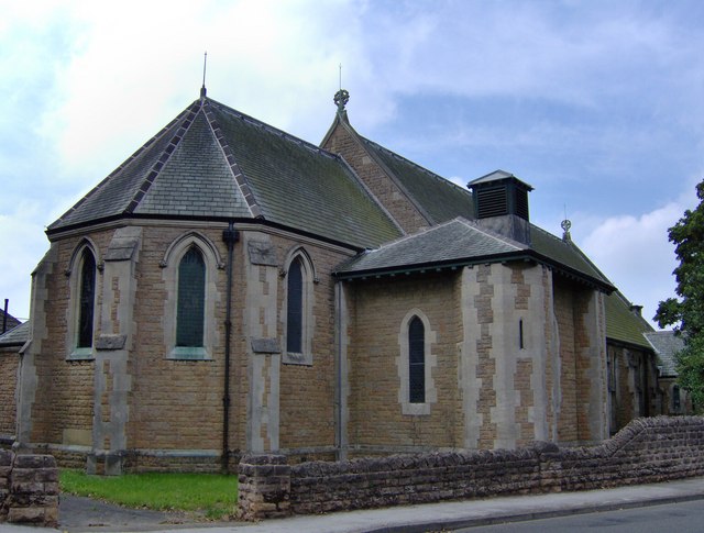
St John the Evangelist's Church, Kirkby Woodhouse

St John the Evangelist's Church, Kirkby-in-Ashfield is a parish church in the Church of England in Kirkby Woodhouse, Nottinghamshire. == History == St...

Annesley

Annesley is a village and civil parish in the Ashfield district of Nottinghamshire, England, between Hucknall and Kirkby-in-Ashfield. At the 2011 census...
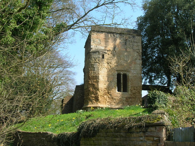
Annesley Old Church

Annesley Old Church or the Church of All Saints, Annesley Park, is a disused church in a ruinous condition which stands on a mound near to Annesley Hall...

Nearby Amenities

Located within 500m of 53.07615,-1.257494
Traffic Calming: yes
Lat/Long: 53.0728056/-1.2575794
Traffic Calming: yes
Lat/Long: 53.0728594/-1.2552031
Traffic Calming: yes
Lat/Long: 53.0730212/-1.2525749
Bus Stop
St Johns Church
Bus: yes
Naptan AtcoCode: 3300AS0209
Naptan Bearing: NW
Naptan CommonName: St Johns Church
Naptan Crossing: Osbourne Street
Naptan Indicator: adj
Naptan Landmark: St Johns Church
Naptan NaptanCode: ntsdwtgm
Naptan Notes: none
Naptan Street: Skegby Road
Naptan Verified: no
Public Transport: platform
Source: naptan_import
Lat/Long: 53.0784115/-1.259825
Bus Stop
Fox Street
Bus: yes
Departures Board: realtime
Naptan AtcoCode: 3300AS0234
Naptan Bearing: SW
Naptan CommonName: Fox Road
Naptan Crossing: Fox Street
Naptan Indicator: opp
Naptan Landmark: Annesley Welfare Club
Naptan NaptanCode: ntsdgdwj
Naptan Notes: none
Naptan Street: Forest Road
Naptan Verified: no
Public Transport: platform
Shelter: yes
Source: naptan_import
Lat/Long: 53.0766177/-1.2546917
Bus Stop
St Johns Church
Bus: yes
Naptan AtcoCode: 3300AS0251
Naptan Bearing: SE
Naptan CommonName: St Johns Church
Naptan Crossing: Osbourne Street
Naptan Indicator: opp
Naptan Landmark: St Johns Church
Naptan NaptanCode: ntsdtjwj
Naptan Notes: none
Naptan Street: Skegby Road
Naptan Verified: no
Public Transport: platform
Source: naptan_import
Lat/Long: 53.0782724/-1.2587758
Bus Stop
Little Oak Drive
Bus: yes
Departures Board: timetable
Naptan AtcoCode: 3300AS0347
Naptan NaptanCode: ntsdwdgt
Public Transport: platform
Shelter: no
Lat/Long: 53.0729119/-1.2560411
Bus Stop
Lawns Road
Bus: yes
Departures Board: timetable
Naptan AtcoCode: 3300AS0554
Naptan Bearing: SE
Naptan CommonName: Lawns Road
Naptan Crossing: Lawns Road
Naptan Indicator: adj
Naptan Landmark: General Havelock
Naptan NaptanCode: ntsdtawt
Naptan Notes: None
Naptan Street: Skegby Road
Naptan Verified: yes
Public Transport: platform
Shelter: no
Source: naptan_import
Lat/Long: 53.0770424/-1.2579237
Bus Stop
Fox Street
Bus: yes
Departures Board: realtime
Naptan AtcoCode: 3300AS0555
Naptan Bearing: NE
Naptan CommonName: Fox Road
Naptan Crossing: Fox Road
Naptan Indicator: adj
Naptan Landmark: Annesley Welfare Club
Naptan NaptanCode: ntsdtdad
Naptan Notes: None
Naptan Street: Forest Road
Naptan Verified: no
Public Transport: platform
Shelter: yes
Source: naptan_import
Lat/Long: 53.0767812/-1.2543832
Bus Stop
Little Oak Drive
Bus: yes
Departures Board: timetable
Naptan AtcoCode: 3300AS0586
Naptan NaptanCode: ntsdtgdm
Public Transport: platform
Shelter: no
Lat/Long: 53.0729542/-1.2558775
Bus Stop
Willow Drive Top
Bus: yes
Departures Board: realtime
Naptan AtcoCode: 3300AS0587
Naptan NaptanCode: ntsdtgdp
Public Transport: platform
Shelter: yes
Lat/Long: 53.0726772/-1.2577681
Bus Stop
Willow Drive Top
Bus: yes
Departures Board: timetable
Naptan AtcoCode: 3300AS0588
Naptan NaptanCode: ntsdtgdt
Public Transport: platform
Shelter: no
Lat/Long: 53.0725267/-1.2576946
Bus Stop
Prolog
Bus: yes
Departures Board: timetable
Public Transport: platform
Shelter: no
Lat/Long: 53.0727978/-1.2542137
Bus Stop
Prolog
Bus: yes
Departures Board: timetable
Naptan AtcoCode: 3300AS0609
Naptan NaptanCode: ntsgawgw
Public Transport: platform
Shelter: no
Lat/Long: 53.0728657/-1.2540893
Bus Stop
Lawns Road
Bus: yes
Departures Board: timetable
Naptan AtcoCode: 3300AS0738
Naptan Bearing: NW
Naptan BusStopType: CUS
Naptan CommonName: Lawns Road
Naptan Crossing: Lawns Road
Naptan Indicator: opp
Naptan Landmark: General Havelock
Naptan NaptanCode: ntsgjpgt
Naptan Notes: CUS--3300AS0554
Naptan Street: Skegby Road
Naptan Verified: yes
Public Transport: platform
Shelter: no
Source: naptan_import
Lat/Long: 53.0769713/-1.2580444
Post Box
Ele: 173.0000000
Lat/Long: 53.0782787/-1.2593303
Ele: 161.0000000
Lat/Long: 53.0742568/-1.2612776
Ele: 154.0000000
Lat/Long: 53.0730129/-1.2621745
Ele: 170.0000000
Lat/Long: 53.0792073/-1.2629057
Post Office
Annesley Woodhouse Post Office
Addr Postcode: NG17 9JB
Branch: Annesley Woodhouse
Brand: Post Office
Brand Wikidata: Q1783168
Check Date: 2020-02-20
Contact Website: https://www.postoffice.co.uk/branch-finder/1602276/annesley-woodhouse
Ref Pol Id: 3652
Lat/Long: 53.0765035/-1.2562431
Traffic Calming: yes
Lat/Long: 53.0731081/-1.25689
Traffic Calming: yes
Lat/Long: 53.0728882/-1.2534792
Barrier: stile
Steps: 1
Stile: stepover
Lat/Long: 53.0750628/-1.262709
Barrier: stile
Steps: 1
Stile: stepover
Lat/Long: 53.0771779/-1.2616453
Barrier: kissing_gate
Lat/Long: 53.0782633/-1.2605804
Barrier: cycle_barrier
Lat/Long: 53.0782829/-1.2586842
Barrier: stile
Steps: 1
Stile: stepover
Lat/Long: 53.0761691/-1.263334
Barrier: kissing_gate
Lat/Long: 53.0792905/-1.253064
Fast Food
Fortuna
Cuisine: chinese
Lat/Long: 53.0767126/-1.2547274
Fast Food
Forest Road Fish Bar and Kebabs
Cuisine: fish_and_chips
Lat/Long: 53.0767048/-1.2548004
Pub
Squire Musters
Opening Hours: mo=sa;su 12:00-14:30
Real Ale: 3 or so
Lat/Long: 53.0766301/-1.2551866
Ian White's
Shop: convenience
Lat/Long: 53.0771007/-1.2527893
Pharmacy
Well Pharmacy
Brand: Well Pharmacy
Brand Wikidata: Q7726524
Brand Wikipedia: en:Well Pharmacy
Healthcare: pharmacy
Website: https://finder.well.co.uk/store/annesley-forest-road
Lat/Long: 53.076962/-1.2533902
Generator Method: photovoltaic
Generator Output Electricity: yes
Generator Source: solar
Generator Type: solar_photovoltaic_panel
Location: roof
Power: generator
Lat/Long: 53.0804091/-1.2588613
Generator Method: photovoltaic
Generator Output Electricity: yes
Generator Source: solar
Generator Type: solar_photovoltaic_panel
Location: roof
Power: generator
Lat/Long: 53.0798053/-1.2583449
Direction: SW
Generator Method: photovoltaic
Generator Output Electricity: yes
Generator Solar Modules: 18
Generator Source: solar
Generator Type: solar_photovoltaic_panel
Location: roof
Power: generator
Lat/Long: 53.0797391/-1.2570266
Direction: 215
Generator Method: photovoltaic
Generator Output Electricity: yes
Generator Solar Modules: 18
Generator Source: solar
Generator Type: solar_photovoltaic_panel
Location: roof
Power: generator
Lat/Long: 53.0800268/-1.2564988
Direction: WNW
Generator Method: photovoltaic
Generator Output Electricity: yes
Generator Solar Modules: 8
Generator Source: solar
Generator Type: solar_photovoltaic_panel
Location: roof
Power: generator
Lat/Long: 53.0792039/-1.2570776
Direction: 185
Generator Method: photovoltaic
Generator Output Electricity: yes
Generator Solar Modules: 6
Generator Source: solar
Generator Type: solar_photovoltaic_panel
Location: roof
Power: generator
Lat/Long: 53.079673/-1.2558632
Direction: SW
Generator Method: photovoltaic
Generator Output Electricity: yes
Generator Solar Modules: 18
Generator Source: solar
Generator Type: solar_photovoltaic_panel
Location: roof
Power: generator
Lat/Long: 53.0803235/-1.2567348
Direction: SSE
Generator Method: photovoltaic
Generator Output Electricity: yes
Generator Solar Modules: 12
Generator Source: solar
Generator Type: solar_photovoltaic_panel
Location: roof
Power: generator
Lat/Long: 53.0774474/-1.2513098
Direction: 170
Generator Method: photovoltaic
Generator Output Electricity: yes
Generator Solar Modules: 16
Generator Source: solar
Generator Type: solar_photovoltaic_panel
Location: roof
Power: generator
Lat/Long: 53.0761077/-1.2582845
Generator Method: photovoltaic
Generator Output Electricity: yes
Generator Source: solar
Generator Type: solar_photovoltaic_panel
Location: roof
Power: generator
Lat/Long: 53.0756603/-1.2593014
Generator Method: photovoltaic
Generator Output Electricity: yes
Generator Source: solar
Generator Type: solar_photovoltaic_panel
Location: roof
Power: generator
Lat/Long: 53.0760237/-1.2601636
Direction: WSW
Generator Method: photovoltaic
Generator Output Electricity: yes
Generator Solar Modules: 4
Generator Source: solar
Generator Type: solar_photovoltaic_panel
Location: roof
Power: generator
Lat/Long: 53.0767951/-1.2582556
Direction: SSE
Generator Method: photovoltaic
Generator Output Electricity: yes
Generator Solar Modules: 4
Generator Source: solar
Generator Type: solar_photovoltaic_panel
Location: roof
Power: generator
Lat/Long: 53.0767969/-1.2583261
Direction: SSE
Generator Method: photovoltaic
Generator Output Electricity: yes
Generator Solar Modules: 12
Generator Source: solar
Generator Type: solar_photovoltaic_panel
Location: roof
Power: generator
Lat/Long: 53.0771558/-1.2560287
Direction: S
Generator Method: photovoltaic
Generator Output Electricity: yes
Generator Solar Modules: 16
Generator Source: solar
Generator Type: solar_photovoltaic_panel
Location: roof
Power: generator
Lat/Long: 53.0781818/-1.2567756
Direction: S
Generator Method: photovoltaic
Generator Output Electricity: yes
Generator Solar Modules: 16
Generator Source: solar
Generator Type: solar_photovoltaic_panel
Location: roof
Power: generator
Lat/Long: 53.078156/-1.2560943
Direction: 275
Generator Method: photovoltaic
Generator Output Electricity: yes
Generator Solar Modules: 6
Generator Source: solar
Generator Type: solar_photovoltaic_panel
Location: roof
Power: generator
Lat/Long: 53.0797034/-1.2559092
Direction: SSW
Generator Method: photovoltaic
Generator Output Electricity: yes
Generator Solar Modules: 10
Generator Source: solar
Generator Type: solar_photovoltaic_panel
Location: roof
Power: generator
Lat/Long: 53.0792452/-1.2573996
Direction: S
Generator Method: photovoltaic
Generator Output Electricity: yes
Generator Solar Modules: 10
Generator Source: solar
Generator Type: solar_photovoltaic_panel
Location: roof
Power: generator
Lat/Long: 53.0799749/-1.2535609
Direction: 215
Generator Method: photovoltaic
Generator Output Electricity: yes
Generator Solar Modules: 10
Generator Source: solar
Generator Type: solar_photovoltaic_panel
Location: roof
Power: generator
Lat/Long: 53.0805499/-1.2563614
Direction: S
Generator Method: photovoltaic
Generator Output Electricity: yes
Generator Solar Modules: 15
Generator Source: solar
Generator Type: solar_photovoltaic_panel
Location: roof
Power: generator
Lat/Long: 53.07997/-1.2536433
Generator Method: photovoltaic
Generator Output Electricity: yes
Generator Source: solar
Generator Type: solar_photovoltaic_panel
Location: roof
Power: generator
Lat/Long: 53.0757558/-1.2566802
Direction: SSE
Generator Method: photovoltaic
Generator Output Electricity: yes
Generator Solar Modules: 6
Generator Source: solar
Generator Type: solar_photovoltaic_panel
Location: roof
Power: generator
Lat/Long: 53.0769975/-1.256745
Direction: WNW
Generator Method: photovoltaic
Generator Output Electricity: yes
Generator Solar Modules: 8
Generator Source: solar
Generator Type: solar_photovoltaic_panel
Location: roof
Power: generator
Lat/Long: 53.0793791/-1.2540375
Direction: ESE
Generator Method: photovoltaic
Generator Output Electricity: yes
Generator Solar Modules: 6
Generator Source: solar
Generator Type: solar_photovoltaic_panel
Location: roof
Power: generator
Lat/Long: 53.0793706/-1.2539528
Direction: ESE
Generator Method: photovoltaic
Generator Output Electricity: yes
Generator Solar Modules: 5
Generator Source: solar
Generator Type: solar_photovoltaic_panel
Location: roof
Power: generator
Lat/Long: 53.0787562/-1.2542213
Direction: WNW
Generator Method: photovoltaic
Generator Output Electricity: yes
Generator Solar Modules: 3
Generator Source: solar
Generator Type: solar_photovoltaic_panel
Location: roof
Power: generator
Lat/Long: 53.0787698/-1.2543049
Direction: 185
Generator Method: photovoltaic
Generator Output Electricity: yes
Generator Solar Modules: 10
Generator Source: solar
Generator Type: solar_photovoltaic_panel
Location: roof
Power: generator
Lat/Long: 53.080348/-1.2557356
Direction: SE
Generator Method: photovoltaic
Generator Output Electricity: yes
Generator Solar Modules: 14
Generator Source: solar
Generator Type: solar_photovoltaic_panel
Location: roof
Power: generator
Lat/Long: 53.0802578/-1.2559742
Direction: SSE
Generator Method: photovoltaic
Generator Output Electricity: yes
Generator Solar Modules: 8
Generator Source: solar
Generator Type: solar_photovoltaic_panel
Location: roof
Power: generator
Lat/Long: 53.078434/-1.2510959
Direction: SW
Generator Method: photovoltaic
Generator Output Electricity: yes
Generator Solar Modules: 2
Generator Source: solar
Generator Type: solar_photovoltaic_panel
Location: roof
Power: generator
Lat/Long: 53.0802349/-1.2559218
Direction: SSE
Generator Method: photovoltaic
Generator Output Electricity: yes
Generator Solar Modules: 13
Generator Source: solar
Generator Type: solar_photovoltaic_panel
Location: roof
Power: generator
Lat/Long: 53.0764021/-1.2546025
Direction: 275
Generator Method: photovoltaic
Generator Output Electricity: yes
Generator Solar Modules: 4
Generator Source: solar
Generator Type: solar_photovoltaic_panel
Location: roof
Power: generator
Lat/Long: 53.0803017/-1.2556951
Direction: ESE
Generator Method: photovoltaic
Generator Output Electricity: yes
Generator Solar Modules: 8
Generator Source: solar
Generator Type: solar_photovoltaic_panel
Location: roof
Power: generator
Lat/Long: 53.0791631/-1.2570246
Direction: WSW
Generator Method: photovoltaic
Generator Output Electricity: yes
Generator Solar Modules: 4
Generator Source: solar
Generator Type: solar_photovoltaic_panel
Location: roof
Power: generator
Lat/Long: 53.0784394/-1.2511537
Direction: WSW
Generator Method: photovoltaic
Generator Output Electricity: yes
Generator Solar Modules: 4
Generator Source: solar
Generator Type: solar_photovoltaic_panel
Location: roof
Power: generator
Lat/Long: 53.0775459/-1.2585291
Street Lamp
Lamp Mount: straight_mast
Lamp Type: led
Lat/Long: 53.0783338/-1.2513204
Man Made: utility_pole
Material: wood
Operator: BT
Utility: telecom
Lat/Long: 53.0783929/-1.2511866
Man Made: utility_pole
Material: wood
Operator: BT
Utility: telecom
Lat/Long: 53.0787861/-1.2516361
Street Lamp
Lamp Mount: straight_mast
Lamp Type: led
Lat/Long: 53.078739/-1.2519552
Street Lamp
Lamp Mount: straight_mast
Lamp Type: led
Lat/Long: 53.0788577/-1.2516892
Man Made: utility_pole
Material: wood
Operator: BT
Utility: telecom
Lat/Long: 53.0781759/-1.2512227
Man Made: utility_pole
Material: wood
Operator: BT
Utility: telecom
Lat/Long: 53.0779097/-1.2514894
Street Lamp
Lamp Mount: straight_mast
Lamp Type: led
Lat/Long: 53.077907/-1.2515042
Man Made: utility_pole
Material: wood
Operator: BT
Utility: telecom
Lat/Long: 53.0779075/-1.251936
Street Lamp
Lamp Mount: straight_mast
Lamp Type: led
Lat/Long: 53.0780611/-1.2510003
Street Lamp
Lamp Mount: straight_mast
Lamp Type: led
Lat/Long: 53.077704/-1.2507992
Man Made: utility_pole
Material: wood
Operator: BT
Utility: telecom
Lat/Long: 53.0776512/-1.2507658
Waste Basket
Lat/Long: 53.0774941/-1.250881
Power: substation
Lat/Long: 53.0775435/-1.25095
Man Made: utility_pole
Material: wood
Operator: BT
Utility: telecom
Lat/Long: 53.0773707/-1.2506745
Street Lamp
Lamp Mount: straight_mast
Lamp Type: led
Lat/Long: 53.0773671/-1.2506858
Man Made: water_works
Lat/Long: 53.0767797/-1.2594455
Atm
Lat/Long: 53.0773045/-1.2577553
Fire Hydrant
Emergency: fire_hydrant
Fire Hydrant Type: underground
Water Source: main
Lat/Long: 53.0769652/-1.2531939
Fire Hydrant
Emergency: fire_hydrant
Fire Hydrant Type: underground
Water Source: main
Lat/Long: 53.0768865/-1.2536012
Fire Hydrant
Emergency: fire_hydrant
Fire Hydrant Type: underground
Water Source: main
Lat/Long: 53.0766886/-1.2546754
Fire Hydrant
Emergency: fire_hydrant
Fire Hydrant Type: underground
Water Source: main
Lat/Long: 53.076624/-1.2545739
Fire Hydrant
Emergency: fire_hydrant
Fire Hydrant Type: underground
Water Source: main
Lat/Long: 53.0762476/-1.2567294
Waste Basket
Lat/Long: 53.0729804/-1.2559356
Communication Amateur Radio: yes
Frequency: 144, 432
Height: 5
Man Made: antenna
Manufacturer: Diamond
Operator: M0ORY
Lat/Long: 53.078401/-1.2516037
Camera Mount: wall
Camera Type: dome
Man Made: surveillance
Surveillance: outdoor
Surveillance Type: camera
Surveillance Zone: shophttp://www.g0raf.co.uk/
Lat/Long: 53.0772596/-1.2580091
Camera Mount: wall
Camera Type: dome
Man Made: surveillance
Surveillance: outdoor
Surveillance Type: camera
Surveillance Zone: shophttp://www.g0raf.co.uk/
Lat/Long: 53.0772904/-1.257837
Camera Mount: pole
Camera Type: panning
Man Made: surveillance
Surveillance: outdoor
Surveillance Type: camera
Surveillance Zone: building
Lat/Long: 53.0732849/-1.25549
Camera Mount: wall
Camera Type: dome
Man Made: surveillance
Surveillance: outdoor
Surveillance Type: camera
Surveillance Zone: building
Lat/Long: 53.0764294/-1.256249
Direction: 70
Man Made: surveillance
Surveillance: public
Surveillance Type: ALPR
Surveillance Zone: traffic
Lat/Long: 53.0759351/-1.2591519
Crossing
Crossing: unmarked
Crossing Markings: no
Lat/Long: 53.0722871/-1.2580233
Crossing
Crossing: unmarked
Crossing Markings: no
Lat/Long: 53.0732828/-1.2575652
Crossing
Crossing: unmarked
Crossing Markings: no
Lat/Long: 53.0731206/-1.2565223
Crossing
Crossing: unmarked
Crossing Markings: no
Lat/Long: 53.0729697/-1.2555289
Crossing
Crossing: unmarked
Crossing Markings: no
Lat/Long: 53.0730296/-1.2531342
The data included in this document is from www.openstreetmap.org. The data is made available under ODbL.

Have you been to Annesley Woodhouse?

Leave your review of Annesley Woodhouse below (or comments, questions and feedback).