Clapham

Settlement in Bedfordshire

England

Clapham

Brewpoint Bedford - brewery, roastery, shop, eating and gathering hub
Brewpoint Bedford - brewery, roastery, shop, eating and gathering hub Credit: JThomas

Clapham is a small village located in the county of Bedfordshire, England. It is situated approximately 2 miles north-west of the town of Bedford and has a population of around 3,000 residents. The village is nestled in a picturesque countryside setting, surrounded by lush green fields and rolling hills.

Clapham has a rich history dating back to the medieval period, with evidence of human habitation in the area since prehistoric times. The village is known for its charming architecture, with many traditional thatched cottages and historic buildings still standing. St. Thomas's Church, a beautiful Grade I listed building, is a prominent feature in the village and is believed to date back to the 13th century.

Despite its small size, Clapham offers a range of amenities for its residents. These include a primary school, a village hall, a local shop, and several pubs and restaurants. The village also benefits from a strong sense of community, with various social and recreational activities taking place throughout the year.

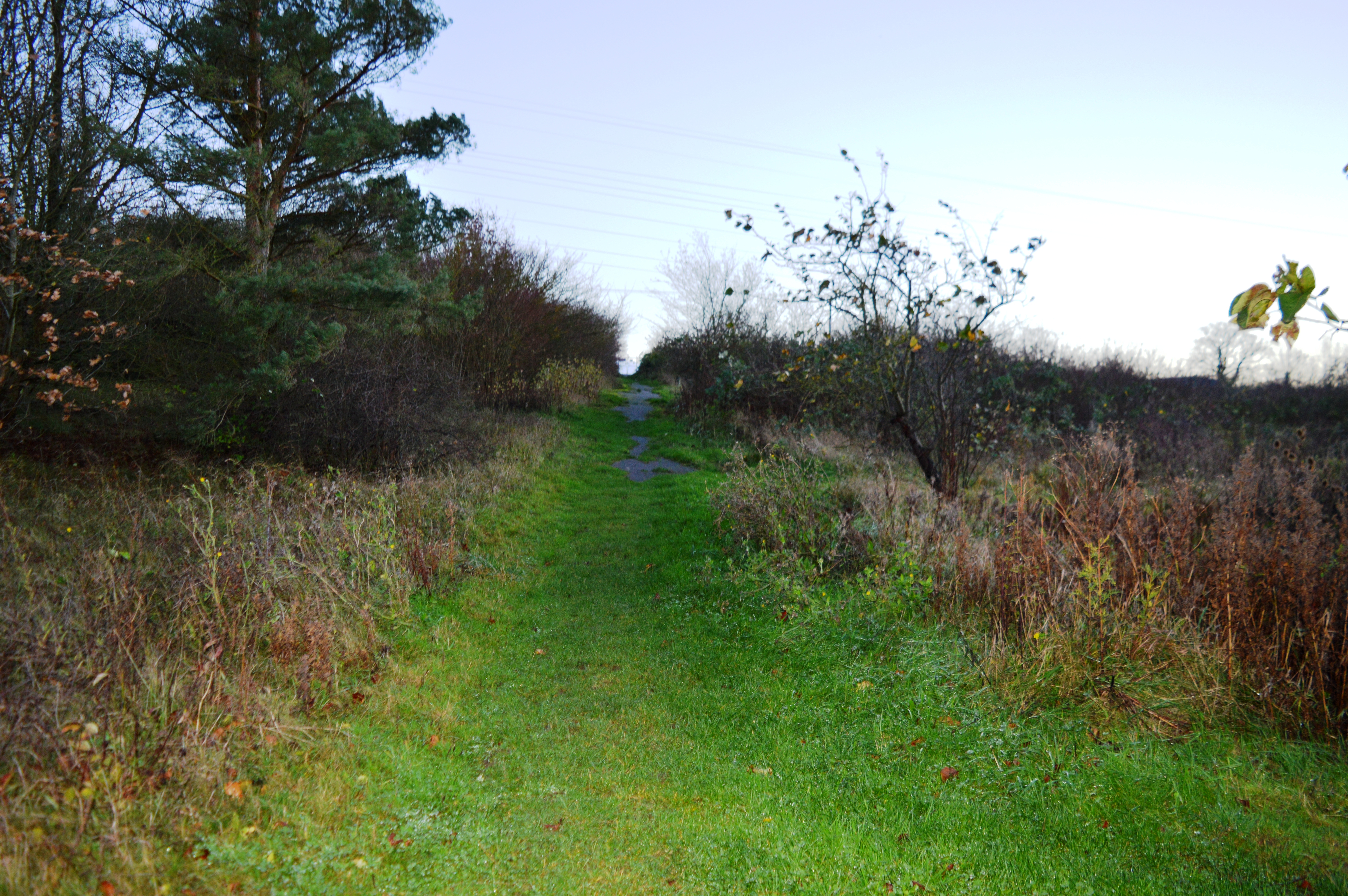
The surrounding natural landscape provides ample opportunities for outdoor activities. Clapham Park, a large public green space, offers a peaceful retreat for walking, picnicking, and enjoying nature. Additionally, the nearby River Great Ouse offers opportunities for fishing and boating enthusiasts.

Clapham's proximity to the town of Bedford ensures easy access to a wider range of amenities, including shopping centers, schools, and healthcare facilities. The village is also well-connected by road and rail, with good transportation links to nearby towns and cities.

Overall, Clapham is a charming and peaceful village, offering a close-knit community and a beautiful rural setting for its residents.

If you have any feedback on the listing, please let us know in the comments section below.

Clapham Images

Images are sourced within 2km of 52.160646/-0.49515844 or Grid Reference TL0352. Thanks to Geograph Open Source API. All images are credited.

Brewpoint Bedford - brewery, roastery, shop, eating and gathering hub
Sign for Brewpoint Bedford
Aldi supermarket
Aldi supermarket
A600 approaching roundabout
Houses on Clapham Road
Entrance to Clapham Water Treatment Works off Clapham Road
Dual use path beside Clapham Road
Bedford / Clapham boundary stone dated 1934
Thatched cottage on Bedford Road
Houses on High Street
The Horse & Groom
The Horse & Groom
Sign for the Horse & Groom
High Street
High Street
Houses on High Street
The Fox & Hounds
The Fox & Hounds
Sign for the Fox & Hounds
A6 access road
A6 access road
Show me another place!

Clapham is located at Grid Ref: TL0352 (Lat: 52.160646, Lng: -0.49515844)

Unitary Authority: Bedford

Police Authority: Bedfordshire

What 3 Words

///tall.wing.force. Near Clapham, Bedfordshire

Related Wikis

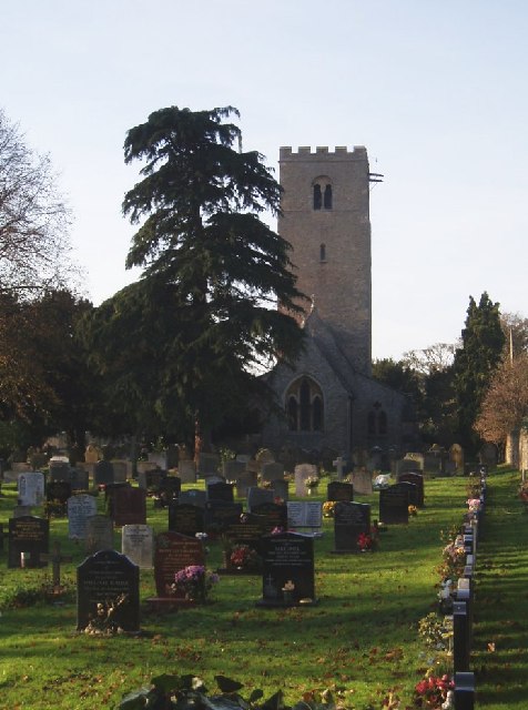
Church of St Thomas of Canterbury, Clapham, Bedfordshire

Church of St Thomas of Canterbury (also Clapham Parish Church, or Thomas à Becket) is a parish church and Grade I listed building in Clapham, Bedfordshire...

Clapham, Bedfordshire

Clapham is a village and civil parish in the Borough of Bedford in Bedfordshire, England. It had a population of 3,643 as at the 2001 census, increasing...

Bromham Lake

Bromham Lake is a 10.9 hectare Local Nature Reserve east of Bromham in Bedfordshire. It is owned and managed by Bedford Borough Council.The lake was formed...

Bedford & County Golf Club

Bedford & County Golf Club is a golf club to the northeast of Clapham, Bedfordshire, England. It was established in 1912. As of 1995 the course measured...

Park Wood, Bedford

Park Wood is a 5.2 hectare Local Nature Reserve located in the Brickhill area of Bedford. It is owned by Bedford Borough Council and managed by the council...

Bedford Modern School

Bedford Modern School (often called BMS) is a Headmasters' and Headmistresses' Conference independent school in Bedford, England. The school has its origins...

Harpur

Harpur is an electoral ward and area within the town of Bedford, England. The boundaries of Harpur are approximately Manton Lane to the north, De Parys...

Lincroft Academy

Lincroft Academy is a co-educational secondary school located in Oakley in the English county of Bedfordshire.It was established as a secondary modern...

Nearby Amenities

Located within 500m of 52.160646,-0.49515844
Post Office
Clapham Post Office
Addr City: Clapham
Addr Country: GB
Addr Housenumber: 48
Addr Postcode: MK41 6DN
Addr Street: High Street
Brand: Post Office
Brand Wikidata: Q1783168
Fhrs Authority: Bedford
Fhrs Id: 103427
Fhrs Local Authority Id: 34750
Ref Pol Id: 361
Website: https://www.postoffice.co.uk/branch-finder/063106x/clapham
Wheelchair: no
Lat/Long: 52.1601919/-0.4925219
Restaurant
Bellini's
Addr City: Clapham
Addr Country: GB
Addr Housenumber: 44,46
Addr Postcode: MK41 6EG
Addr Street: High Street
Fhrs Authority: Bedford
Fhrs Id: 103424
Fhrs Local Authority Id: 34748
Wheelchair: yes
Lat/Long: 52.1602045/-0.4921953
Pub
The Star
Addr City: Clapham
Addr Country: GB
Addr Housenumber: 42
Addr Postcode: MK41 6EG
Addr Street: High Street
Fhrs Authority: Bedford
Fhrs Id: 103422
Fhrs Local Authority Id: 34746
Wheelchair: no
Lat/Long: 52.1601477/-0.4920456
Bench
Backrest: yes
Lat/Long: 52.1591755/-0.4889445
Barrier: stile
Lat/Long: 52.1568721/-0.4928714
Parking
Lat/Long: 52.1606839/-0.4878905
Crossing: informal
Lat/Long: 52.1633581/-0.4938549
The Wedding Boutique
Shop: florist
Wheelchair: yes
Lat/Long: 52.160755/-0.4945515
Cafe
Caffe Piccolo
Addr City: Clapham
Addr Country: GB
Addr Housenumber: 78
Addr Postcode: MK41 6BW
Addr Street: High Street
Fhrs Authority: Bedford
Fhrs Id: 103444
Fhrs Local Authority Id: 34762
Shop: bakery
Wheelchair: yes
Lat/Long: 52.1606213/-0.4939588
Power: tower
Source: bing
Lat/Long: 52.1595726/-0.4985745
Power: tower
Source: bing
Lat/Long: 52.1587499/-0.4942937
PDM Car Parts & Accessories
Shop: car_parts
Lat/Long: 52.1606483/-0.4940497
Crossing
Crossing: traffic_signals
Crossing Ref: pelican
Lat/Long: 52.1606118/-0.4949638
Crossing: traffic_signals
Lat/Long: 52.1598994/-0.4912192
Post Box
Brand: Royal Mail
Brand Wikidata: Q638098
Collection Times: Mo-Fr 17:30; Sa 11:00
Operator: Royal Mail
Operator Wikidata: Q638098
Post Box Type: pillar
Ref: MK41 115
Royal Cypher: EIIR
Royal Cypher Wikidata: Q33102113
Source: survey
Survey Date: 2016-04-30
Lat/Long: 52.160218/-0.4927439
Post Box
Brand: Royal Mail
Brand Wikidata: Q638098
Check Date: 2021-06-14
Collection Times: Mo-Fr 09:00, Sa 07:00
Operator: Royal Mail
Operator Wikidata: Q638098
Post Box Type: lamp
Ref: MK41 68
Royal Cypher: EIIR
Royal Cypher Wikidata: Q33102113
Source: survey
Lat/Long: 52.1624358/-0.4999805
Post Box
Brand: Royal Mail
Brand Wikidata: Q638098
Collection Times: Mo-Fr 17:45; Sa 11:15
Operator: Royal Mail
Operator Wikidata: Q638098
Post Box Type: wall
Ref: MK41 342
Royal Cypher: GVIR
Royal Cypher Wikidata: Q33102169
Source: survey
Survey Date: 2016-04-30
Lat/Long: 52.1637716/-0.4935506
Oktober
Shop: hairdresser
Lat/Long: 52.1607853/-0.4946691
Jagged Edge
Shop: hairdresser
Lat/Long: 52.1608083/-0.4948005
Fast Food
Mandarin House
Addr City: Clapham
Addr Country: GB
Addr Housenumber: 58a
Addr Postcode: MK41 6DN
Addr Street: High Street
Fhrs Authority: Bedford
Fhrs Id: 103429
Fhrs Local Authority Id: 34752
Lat/Long: 52.1602801/-0.4929015
Fast Food
Good Chef Chinese Takeaway
Addr City: Clapham
Addr Country: GB
Addr Housenumber: 82
Addr Postcode: MK41 6BW
Addr Street: High Street
Fhrs Authority: Bedford
Fhrs Id: 103446
Fhrs Local Authority Id: 34765
Lat/Long: 52.1606586/-0.4941541
Fast Food
Zeera Tandoori
Addr City: Clapham
Addr Country: GB
Addr Housenumber: 84
Addr Postcode: MK41 6BW
Addr Street: High Street
Fhrs Authority: Bedford
Fhrs Id: 50336
Fhrs Local Authority Id: 112060
Lat/Long: 52.1606849/-0.4942748
Fast Food
Clapham Bar B Q
Addr City: Clapham
Addr Country: GB
Addr Housenumber: 86
Addr Postcode: MK41 6BW
Addr Street: High Street
Fhrs Id: 103449
Fhrs Local Authority Id: 34768
Lat/Long: 52.1607145/-0.4943687
Pharmacy
Herbert & Herbert Pharmacy
Addr City: Clapham
Addr Country: GB
Addr Housenumber: 88
Addr Postcode: MK41 6BW
Addr Street: High Street
Fhrs Authority: Bedford
Fhrs Id: 103455
Fhrs Local Authority Id: 34770
Healthcare: pharmacy
Lat/Long: 52.1607293/-0.4944599
Ford: yes
Lat/Long: 52.1585873/-0.4902052
The data included in this document is from www.openstreetmap.org. The data is made available under ODbL.

Have you been to Clapham?

Leave your review of Clapham below (or comments, questions and feedback).