Anlaby
Settlement in Yorkshire
England
Anlaby

Anlaby is a small village located in the East Riding of Yorkshire, England. Situated approximately four miles west of the city of Hull, it is part of the civil parish of Anlaby with Anlaby Common. Anlaby is surrounded by several other villages, including Kirk Ella, Willerby, and Hessle.
The village has a rich history, with records dating back to the Domesday Book of 1086. Over the years, Anlaby has transformed from a primarily agricultural community into a residential area. It is now a popular suburb for families and professionals working in Hull.
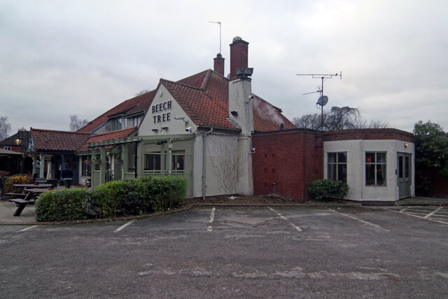
Anlaby offers a range of amenities to its residents, including local shops, pubs, and restaurants. The village also benefits from its proximity to larger shopping centers in nearby towns, providing access to a wider range of retail options.
Residents of Anlaby enjoy easy access to green spaces and recreational areas. The village is surrounded by beautiful countryside, making it a great location for outdoor activities such as walking and cycling. West Ella Road, a major road running through the village, connects Anlaby to the A164, providing convenient transportation links.
Anlaby is home to several notable landmarks, including Anlaby House and Anlaby Park. These historic buildings add to the village's charm and character. The village also has a strong sense of community, with various local events and activities organized throughout the year.
Overall, Anlaby offers a peaceful and picturesque setting, combined with convenient access to amenities and transport links, making it an attractive place to live in the Yorkshire region.
If you have any feedback on the listing, please let us know in the comments section below.
Anlaby Images
Images are sourced within 2km of 53.74348/-0.436965 or Grid Reference TA0328. Thanks to Geograph Open Source API. All images are credited.


Anlaby is located at Grid Ref: TA0328 (Lat: 53.74348, Lng: -0.436965)
Division: East Riding
Unitary Authority: East Riding of Yorkshire
Police Authority: Humberside
What 3 Words
///worked.port.lunch. Near Kirk Ella, East Yorkshire
Nearby Locations
Related Wikis
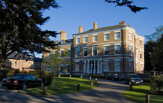
Anlaby House
Anlaby House is a former Georgian country house at Anlaby, near Hull, in the East Riding of Yorkshire, England, which has since been converted to luxury...

Anlaby
Anlaby is a village forming part of the western suburbs of Kingston upon Hull, in the East Riding of Yorkshire, England. It forms part of the civil parish...

Hull and East Riding Hospital
Hull and East Riding Hospital, formerly BUPA Hospital Hull and East Riding is located in Anlaby, East Riding of Yorkshire, England. It is owned by Spire...

Wolfreton School
Wolfreton School & Sixth Form College is a coeducational secondary school and sixth form located in Willerby, East Riding of Yorkshire, England. During...
Nearby Amenities
Located within 500m of 53.74348,-0.436965Have you been to Anlaby?
Leave your review of Anlaby below (or comments, questions and feedback).