Anlaby with Anlaby Common

Civil Parish in Yorkshire

England

Anlaby with Anlaby Common

Haltemprice Leisure, Anlaby The front of the recently-extended leisure centre/library/health centre on Springfield Way. The upper floor is given over to an extensive gym, while the library is on the ground floor to the left of the shot here. The new extension is the wing to the right: images of its construction earlier in 2021 can be seen here: <a href="https://www.geograph.org.uk/photo/6756219">TA0329 : Leisure centre extension work, Haltemprice</a> and here: <a href="https://www.geograph.org.uk/photo/6788861">TA0329 : Progress on leisure centre, Anlaby</a>.
Haltemprice Leisure, Anlaby Credit: Paul Harrop

Anlaby with Anlaby Common is a civil parish located in the East Riding of Yorkshire, England. It is situated approximately 5 miles west of the city of Kingston upon Hull. The parish is made up of two distinct areas: Anlaby, a residential suburb, and Anlaby Common, an area of open land.

Anlaby is a thriving village with a rich history dating back to the Domesday Book. It is known for its picturesque surroundings and well-maintained properties. The village offers a range of amenities, including shops, pubs, and restaurants, making it a popular place to live for families and professionals alike.

Anlaby Common, on the other hand, is a large area of open land that provides a peaceful retreat from the hustle and bustle of urban life. It is a designated local nature reserve and is home to a variety of wildlife, including birds and small mammals. The common offers ample opportunities for outdoor activities, such as walking, jogging, or simply enjoying the natural beauty of the area.

The civil parish of Anlaby with Anlaby Common is well-connected, with easy access to major roads and public transportation. It is also within close proximity to several educational institutions, including primary and secondary schools. Overall, this civil parish offers a balanced mix of urban convenience and natural beauty, making it an attractive place to live or visit.

If you have any feedback on the listing, please let us know in the comments section below.

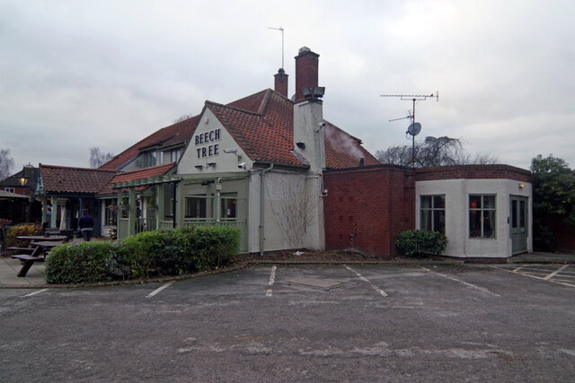
Anlaby with Anlaby Common Images

Images are sourced within 2km of 53.74138/-0.434495 or Grid Reference TA0328. Thanks to Geograph Open Source API. All images are credited.

Haltemprice Leisure, Anlaby The front of the recently-extended leisure centre/library/health centre on Springfield Way. The upper floor is given over to an extensive gym, while the library is on the ground floor to the left of the shot here. The new extension is the wing to the right: images of its construction earlier in 2021 can be seen here: <a href="https://www.geograph.org.uk/photo/6756219">TA0329 : Leisure centre extension work, Haltemprice</a> and here: <a href="https://www.geograph.org.uk/photo/6788861">TA0329 : Progress on leisure centre, Anlaby</a>.
Haltemprice Leisure, Anlaby
The front of the recently-extended leisure centre/library/health centre on Springfield Way. The upper floor is given over to an extensive gym, while the library is on the ground floor to the left of the shot here. The new extension is the wing to the right: images of its construction earlier in 2021 can be seen here: TA0329 : Leisure centre extension work, Haltemprice and here: TA0329 : Progress on leisure centre, Anlaby.
The Beech Tree, Kirk Ella Part of the Ember Inns chain, this large suburban pub is located on Southella Way. It was built in 1979 but sadly the beech tree after which it was named died shortly afterwards.
The Beech Tree, Kirk Ella
Part of the Ember Inns chain, this large suburban pub is located on Southella Way. It was built in 1979 but sadly the beech tree after which it was named died shortly afterwards.
Suburban squirrel, Hull One of the many well-fed grey squirrels which thrive in the back gardens of the area, thanks in part to the number of residents who keep their bird feeders well-stocked and easily-raided.
Suburban squirrel, Hull
One of the many well-fed grey squirrels which thrive in the back gardens of the area, thanks in part to the number of residents who keep their bird feeders well-stocked and easily-raided.
American football practice, Hull The 'egg-chasing' affectionately derided by the city's Association Football fans is traditionally aimed at the local Rugby League community. But this Sunday session on the Costello Playing Fields suggests a possible new target for them.
American football practice, Hull
The 'egg-chasing' affectionately derided by the city's Association Football fans is traditionally aimed at the local Rugby League community. But this Sunday session on the Costello Playing Fields suggests a possible new target for them.
Silver birches and golden daffodils, Hull Springtime colour on the strip of grassland to the north of Willerby Road. I'd always assumed this was just part of the frontage of Springhead Park golf course. But according to one map, this is 'Wymersley Park', not a designation I'd been aware of. There are sports and play facilities to the west of Wymersley Road, which are contiguous with this area. So maybe it is one of the city's more compact official parks.
Silver birches and golden daffodils, Hull
Springtime colour on the strip of grassland to the north of Willerby Road. I'd always assumed this was just part of the frontage of Springhead Park golf course. But according to one map, this is 'Wymersley Park', not a designation I'd been aware of. There are sports and play facilities to the west of Wymersley Road, which are contiguous with this area. So maybe it is one of the city's more compact official parks.
Direction Sign – Signpost on the B1231 Tranby Lane in Anlaby Located in Anlaby on the northwest side of the junction of the B1231 Tranby Lane and the B1232 Beverley Road, Anlaby with Anlaby Common parish. Restored with 3 arms and pawn finial. See also <a title="https://www.geograph.org.uk/photo/6042928" href="https://www.geograph.org.uk/photo/6042928">Link</a> and <a title="https://www.geograph.org.uk/photo/3744982" href="https://www.geograph.org.uk/photo/3744982">Link</a>.

Milestone Society National ID: YE_TA0328
Direction Sign – Signpost on the B1231 Tranby Lane in Anlaby
Located in Anlaby on the northwest side of the junction of the B1231 Tranby Lane and the B1232 Beverley Road, Anlaby with Anlaby Common parish. Restored with 3 arms and pawn finial. See also Link and Link. Milestone Society National ID: YE_TA0328
New Sign  in Kingston Road Hull An eyecatching new modern sign welcoming people to Hull.
New Sign in Kingston Road Hull
An eyecatching new modern sign welcoming people to Hull.
Batter late, then never? Anlaby Common This 'teaser' window display, on Hull Road, Anlaby Common, has been in place since around 2010/2011, when it caused anticipation to run high among local takeaway fans. In the intervening dozen years though, their expectations have been substantially scaled back.  The promised timescale may not be as misleading as it appears, provided your definition of 'few' can be extended to mean '600 or so'.
Batter late, then never? Anlaby Common
This 'teaser' window display, on Hull Road, Anlaby Common, has been in place since around 2010/2011, when it caused anticipation to run high among local takeaway fans. In the intervening dozen years though, their expectations have been substantially scaled back. The promised timescale may not be as misleading as it appears, provided your definition of 'few' can be extended to mean '600 or so'.
Wilson Street, Anlaby Row of shops at the junction with Hull Road, briefly enlivened by a spring display of cherry blossom. The (now closed) Red Lion pub, and the Red Lion Court shop units are in the distance.
Wilson Street, Anlaby
Row of shops at the junction with Hull Road, briefly enlivened by a spring display of cherry blossom. The (now closed) Red Lion pub, and the Red Lion Court shop units are in the distance.
Horse on Anlaby Common Only two horses were grazing in the eastern portion of the open land to the south of Hull Road. A much larger number were in the adjoining field to the west, but none of them would pose as obligingly.
Horse on Anlaby Common
Only two horses were grazing in the eastern portion of the open land to the south of Hull Road. A much larger number were in the adjoining field to the west, but none of them would pose as obligingly.
New houses in Anlaby This short terrace on Wilson Street, along with a number of larger houses on the adjacent Crowle Close, were built in around 2017/2018, replacing long-derelict properties and their adjoining overgrown land on the southern side of the street.
New houses in Anlaby
This short terrace on Wilson Street, along with a number of larger houses on the adjacent Crowle Close, were built in around 2017/2018, replacing long-derelict properties and their adjoining overgrown land on the southern side of the street.
Former chapel, Anlaby Ex-Methodist chapel on Church Street. An earlier, wider view, and history can be seen at <a href="https://www.geograph.org.uk/photo/6093497">TA0328 : Church Street, Anlaby, Yorkshire</a>. Little seems to have changed in the intervening three years, although a new roof has been added, suggesting that the building is still in use.
Former chapel, Anlaby
Ex-Methodist chapel on Church Street. An earlier, wider view, and history can be seen at TA0328 : Church Street, Anlaby, Yorkshire. Little seems to have changed in the intervening three years, although a new roof has been added, suggesting that the building is still in use.
Crossing controller condiment cabinet, Hull One of a number of traffic signal control boxes in the city which have, in the past couple of years, been covered in artwork in a bid to tackle graffiti and vandalism.

This example, on the cycle/pedestrian crossing on Willerby Road, celebrates one of Hull's culinary creations, 'American' Chip Spice. Manufactured by Wilson's Seasonings, <span class="nowrap"><a title="https://americanchipspice.co.uk" rel="nofollow ugc noopener" href="https://americanchipspice.co.uk">Link</a><img style="margin-left:2px;" alt="External link" title="External link - shift click to open in new window" src="https://s1.geograph.org.uk/img/external.png" width="10" height="10"/></span> I'm not aware of it ever having been named or packaged as shown here.

Rob and Brenda Wilson came up with the idea of using spiced salt and paprika after visiting America in the late 1970s. Their chip spice was first introduced to Hull by their friend, restaurant owner John Science. His burger bar, Yankee Burger on Jameson Street made the seasoning famous, before local fish and chip shops also started selling it.
Crossing controller condiment cabinet, Hull
One of a number of traffic signal control boxes in the city which have, in the past couple of years, been covered in artwork in a bid to tackle graffiti and vandalism. This example, on the cycle/pedestrian crossing on Willerby Road, celebrates one of Hull's culinary creations, 'American' Chip Spice. Manufactured by Wilson's Seasonings, LinkExternal link I'm not aware of it ever having been named or packaged as shown here. Rob and Brenda Wilson came up with the idea of using spiced salt and paprika after visiting America in the late 1970s. Their chip spice was first introduced to Hull by their friend, restaurant owner John Science. His burger bar, Yankee Burger on Jameson Street made the seasoning famous, before local fish and chip shops also started selling it.
Double flagging, Willerby A house on Kingston Road combining two topical causes: marking the Queen's Platinum Jubilee and expressing support for Ukraine, in one of the more prominent flag displays in the area.
Double flagging, Willerby
A house on Kingston Road combining two topical causes: marking the Queen's Platinum Jubilee and expressing support for Ukraine, in one of the more prominent flag displays in the area.
Ripening barley, Anlaby Crop in the field alongside Lowfield Road, more of which has gradually succumbed to housing development in recent years, but this pocket of farmland between the suburban settlements of Anlaby and Hessle still rather incongruously hangs on.
Ripening barley, Anlaby
Crop in the field alongside Lowfield Road, more of which has gradually succumbed to housing development in recent years, but this pocket of farmland between the suburban settlements of Anlaby and Hessle still rather incongruously hangs on.
For sale signs, Anlaby Outside The Ridings retirement and sheltered housing complex for older people, the numerous estate agents' boards tell of the sad but inevitable steady turnover of ownership of such properties.
For sale signs, Anlaby
Outside The Ridings retirement and sheltered housing complex for older people, the numerous estate agents' boards tell of the sad but inevitable steady turnover of ownership of such properties.
Torpoint flats, near Hessle Hull City Council-owned tower block on the Boothferry Estate, one of three which were earmarked for demolition by a decision in late 2021. Tenants in this block were the first to be provided with alternative housing during the course of 2022, when the council also plans to appoint demolition contractors, for work to take place in 2023/4. The accommodation lost here will eventually be replaced by the same number of low-rise premises.
Torpoint flats, near Hessle
Hull City Council-owned tower block on the Boothferry Estate, one of three which were earmarked for demolition by a decision in late 2021. Tenants in this block were the first to be provided with alternative housing during the course of 2022, when the council also plans to appoint demolition contractors, for work to take place in 2023/4. The accommodation lost here will eventually be replaced by the same number of low-rise premises.
Festive roundabout, Willerby Christmas lights on the Kingston Road roundabout at its junction with Gorton Road/The Parkway.
Festive roundabout, Willerby
Christmas lights on the Kingston Road roundabout at its junction with Gorton Road/The Parkway.
Show me another place!

Anlaby with Anlaby Common is located at Grid Ref: TA0328 (Lat: 53.74138, Lng: -0.434495)

Division: East Riding

Unitary Authority: East Riding of Yorkshire

Police Authority: Humberside

What 3 Words

///gained.prices.burns. Near Hessle, East Yorkshire

Related Wikis

Hull and East Riding Hospital

Hull and East Riding Hospital, formerly BUPA Hospital Hull and East Riding is located in Anlaby, East Riding of Yorkshire, England. It is owned by Spire...
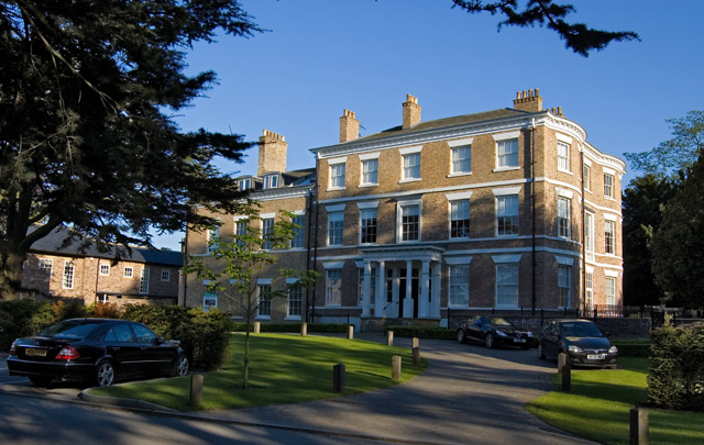
Anlaby House

Anlaby House is a former Georgian country house at Anlaby, near Hull, in the East Riding of Yorkshire, England, which has since been converted to luxury...

Anlaby

Anlaby is a village forming part of the western suburbs of Kingston upon Hull, in the East Riding of Yorkshire, England. It forms part of the civil parish...

Tranby Croft

Tranby Croft is a large Grade II listed Victorian country house and estate at Anlaby, near Hull in the East Riding of Yorkshire, England. The house is...

Nearby Amenities

Located within 500m of 53.74138,-0.434495
Mini Roundabout
Direction: clockwise
Lat/Long: 53.7442644/-0.438583
Post Box
Lat/Long: 53.7394888/-0.4345163
Post Office
Anlaby Post Office
Addr City: Hull
Addr Housenumber: 36
Addr Postcode: HU10 6UA
Addr Street: Hull Road
Addr Village: Anlaby
Opening Hours: Mo-Fr 08:00-18:00; Sa 09:00-17:00
Ref Pol Id: 3219
Lat/Long: 53.7448166/-0.4305447
Post Box
Post Box Design: type_k
Post Box Type: pillar
Lat/Long: 53.7449423/-0.4304623
Bus Stop
Anlaby The Red Lion Pub
Kerb: raised
Naptan AtcoCode: 2200YEA00008
Naptan Bearing: N
Naptan CommonName: Anlaby The Red Lion Pub
Naptan Landmark: The Red Lion Pub
Naptan PlusbusZoneRef: HULL
Naptan Street: Wilson Street
Shelter: yes
Source: naptan + survey
Lat/Long: 53.7454414/-0.4325911
Bus Stop
Anlaby The Red Lion Pub
Kerb: raised
Layby: yes
Naptan AtcoCode: 2200YEA00009
Naptan Bearing: S
Naptan CommonName: Anlaby The Red Lion Pub
Naptan Landmark: Opposite Red Lion Pub
Naptan PlusbusZoneRef: HULL
Naptan Street: Wilson Street
Shelter: yes
Source: naptan + survey
Lat/Long: 53.7454571/-0.4323164
Bus Stop
Anlaby Wilson Street
Kerb: raised
Naptan AtcoCode: 2200YEA00132
Naptan Bearing: W
Naptan CommonName: Anlaby Wilson Street
Naptan Landmark: Near Number 49
Naptan PlusbusZoneRef: HULL
Naptan Street: Wilson Street
Shelter: no
Source: naptan + survey
Lat/Long: 53.7457839/-0.4354142
Bus Stop
Anlaby Beverley Road
Naptan AtcoCode: 2200YEA00141
Naptan Bearing: S
Naptan CommonName: Anlaby Beverley Road
Naptan Landmark: Near Number 339
Naptan PlusbusZoneRef: HULL
Naptan Street: Beverley Road
Note: no code on sign
Shelter: no
Source: naptan + survey
Lat/Long: 53.7446464/-0.4384894
Bus Stop
Anlaby Lowfield Road
Naptan AtcoCode: 2200YEA00641
Naptan Bearing: S
Naptan CommonName: Anlaby Lowfield Road
Naptan Landmark: Hospital
Naptan PlusbusZoneRef: HULL
Naptan Street: Lowfield Road
Note: no code on sign
Shelter: no
Source: naptan + survey
Lat/Long: 53.7394665/-0.4341933
Bus Stop
Anlaby Lowfield Road
Naptan AtcoCode: 2200YEA00642
Naptan Bearing: N
Naptan CommonName: Anlaby Lowfield Road
Naptan Landmark: Hospital
Naptan PlusbusZoneRef: HULL
Naptan Street: Lowfield Road
Note: no code on sign
Shelter: no
Source: naptan + survey
Lat/Long: 53.740019/-0.4340609
Bus Stop
Anlaby Lowfield Road
Naptan AtcoCode: 2200YEA00643
Naptan Bearing: S
Naptan CommonName: Anlaby Lowfield Road
Naptan PlusbusZoneRef: HULL
Naptan Street: Lowfield Road
Note: no code on sign
Shelter: no
Source: naptan + survey
Lat/Long: 53.7419245/-0.4324339
Bus Stop
Anlaby Lowfield Road
Naptan AtcoCode: 2200YEA01448
Naptan Bearing: S
Naptan CommonName: Anlaby Lowfield Road
Naptan Landmark: Lowfield Court
Naptan PlusbusZoneRef: HULL
Naptan Street: Lowfield Road
Note: no sign board, but stop in use
Shelter: yes
Source: naptan + survey
Lat/Long: 53.7449157/-0.4322619
Mini Roundabout
Direction: clockwise
Lat/Long: 53.7380356/-0.4353528
Crossing
Crossing: marked
Lat/Long: 53.7451434/-0.4311103
Noexit: yes
Lat/Long: 53.7396124/-0.4317801
Mini Roundabout
Direction: clockwise
Lat/Long: 53.7399097/-0.4339227
Barrier: cycle_barrier
Bicycle: no
Foot: yes
Lat/Long: 53.7450577/-0.4336122
Barrier: cycle_barrier
Bicycle: no
Foot: yes
Lat/Long: 53.7447844/-0.4336701
Barrier: cycle_barrier
Bicycle: no
Foot: yes
Lat/Long: 53.7447829/-0.4353456
Barrier: cycle_barrier
Bicycle: no
Foot: yes
Lat/Long: 53.7444212/-0.4345018
Crossing
Lat/Long: 53.7396066/-0.4341926
Telephone
Booth: K6
Colour: white
Covered: booth
Phone: +44 1482 657418
Lat/Long: 53.7450458/-0.4321835
Bicycle Parking
Bicycle Parking: stands
Capacity: 8
Covered: no
Lat/Long: 53.7452956/-0.4320219
Clock
Display: analog
Faces: 2
Start Date: 2014
Support: pedestal
Lat/Long: 53.7452959/-0.4321911
Noexit: yes
Lat/Long: 53.7409431/-0.4411349
Noexit: yes
Lat/Long: 53.7410589/-0.4404455
The data included in this document is from www.openstreetmap.org. The data is made available under ODbL.

Have you been to Anlaby with Anlaby Common?

Leave your review of Anlaby with Anlaby Common below (or comments, questions and feedback).