Anerley

Settlement in Surrey / Kent

England

Anerley

Covid instruction sticker on the platform, Norwood Junction station
Covid instruction sticker on the platform, Norwood Junction station Credit: Christopher Hilton

Anerley is a suburban area located in the borough of Bromley, on the border of Surrey and Kent in the southeast of England. Situated approximately 10 miles southeast of central London, Anerley offers a convenient residential location with easy access to both the capital and the surrounding countryside.

The area is primarily residential, characterized by a mix of Victorian terraced houses, modern apartments, and some larger detached properties. It has a diverse and multicultural community, attracting a range of residents from young professionals to families and retirees.

Anerley benefits from its proximity to several green spaces, including Crystal Palace Park and Betts Park, providing residents with opportunities for outdoor activities such as jogging, walking, and picnicking. The area also boasts excellent transport links, with Anerley railway station providing services to London Bridge and London Victoria, making it an attractive option for commuters.

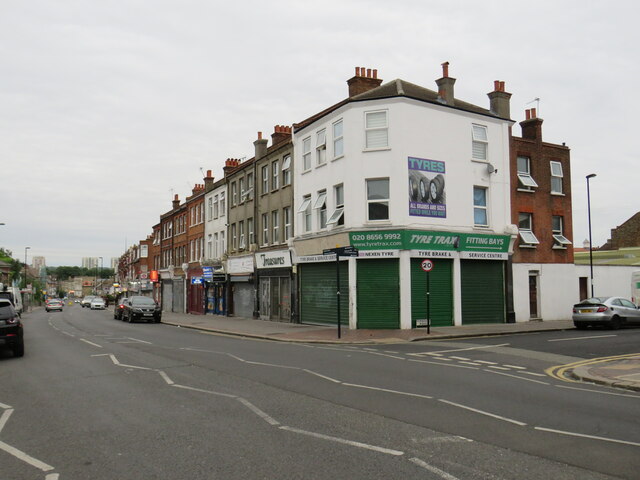
While Anerley itself may not offer an extensive range of amenities, nearby Crystal Palace and Beckenham provide ample shopping and dining options, as well as a vibrant nightlife. The area is also well-served by schools, with a variety of primary and secondary schools in close proximity.

In summary, Anerley is a suburban area that offers a peaceful residential setting within easy reach of central London. With its green spaces, excellent transport links, and a diverse community, it provides a desirable place to live for a range of residents.

If you have any feedback on the listing, please let us know in the comments section below.

Anerley Images

Images are sourced within 2km of 51.408939/-0.065352 or Grid Reference TQ3469. Thanks to Geograph Open Source API. All images are credited.

Covid instruction sticker on the platform, Norwood Junction station
Yeoman House, Penge A mixed use building comprising offices, a car showroom and a hotel
Yeoman House, Penge
A mixed use building comprising offices, a car showroom and a hotel
Whittington Court, Penge
South Norwood Methodist Church
Railway Bridge, South Norwood The bridge carries the rail line between Elmers End and Crystal Palace  over the A213
Railway Bridge, South Norwood
The bridge carries the rail line between Elmers End and Crystal Palace over the A213
Grange Road, Upper Norwood Grange Road is a residential road on a hillside in Upper Norwood, in the suburbs of south London.
Grange Road, Upper Norwood
Grange Road is a residential road on a hillside in Upper Norwood, in the suburbs of south London.
Mayday Madness Old Palace Clog performing at The Lakes Café event at South Norwood Lake.
Mayday Madness
Old Palace Clog performing at The Lakes Café event at South Norwood Lake.
Mayday Madness Old Palace Clog performing at The Lakes Café event at South Norwood Lake.
Mayday Madness
Old Palace Clog performing at The Lakes Café event at South Norwood Lake.
Mayday Madness Old Palace Clog performing at The Lakes Café event at South Norwood Lake.
Mayday Madness
Old Palace Clog performing at The Lakes Café event at South Norwood Lake.
Mayday Madness Old Palace Clog performing at The Lakes Café event at South Norwood Lake.
Mayday Madness
Old Palace Clog performing at The Lakes Café event at South Norwood Lake.
Mayday Madness Old Palace Clog performing at The Lakes Café event at South Norwood Lake.
Mayday Madness
Old Palace Clog performing at The Lakes Café event at South Norwood Lake.
Mayday Madness Old Palace Clog performing at The Lakes Café event at South Norwood Lake.
Mayday Madness
Old Palace Clog performing at The Lakes Café event at South Norwood Lake.
Mayday Madness Old Palace Clog performing at The Lakes Café event at South Norwood Lake. At the end of the dance, the dancers depart to reveal the band of five melodeon players.
Mayday Madness
Old Palace Clog performing at The Lakes Café event at South Norwood Lake. At the end of the dance, the dancers depart to reveal the band of five melodeon players.
Portland Road, South Norwood Portland Road in South Norwood, in the outer suburbs of south London.
Portland Road, South Norwood
Portland Road in South Norwood, in the outer suburbs of south London.
Portland Road, South Norwood Portland Road in South Norwood forms part of the route of the A215.
Portland Road, South Norwood
Portland Road in South Norwood forms part of the route of the A215.
Harrington Road, South Norwood Harrington Road is a residential road in South Norwood, in the outer suburbs of south London.
Harrington Road, South Norwood
Harrington Road is a residential road in South Norwood, in the outer suburbs of south London.
Kent House Station Train services on routes from London Victoria.
Kent House Station
Train services on routes from London Victoria.
Allotments between the railways near Kent House Station This area was once fully enclosed by a triangular railway junction, but the western arc has been dismantled.
Allotments between the railways near Kent House Station
This area was once fully enclosed by a triangular railway junction, but the western arc has been dismantled.
Show me another place!

Anerley is located at Grid Ref: TQ3469 (Lat: 51.408939, Lng: -0.065352)

Unitary Authority: Bromley

Police Authority: Metropolitan

What 3 Words

///saying.actor.snows. Near Thornton Heath, London

Related Wikis

Betts Park

Betts Park (also known as King George's Field) is a public park in Anerley, London Borough of Bromley, in southeast London, England. It is approximately...
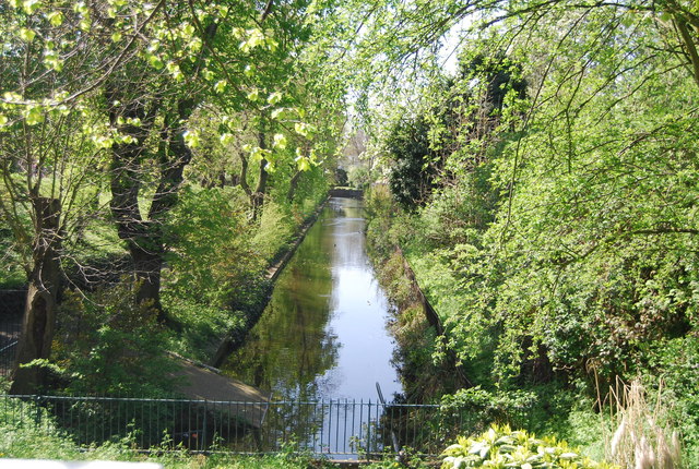
Croydon Canal

The Croydon Canal ran 9+1⁄4 miles (15 km) from Croydon, via Forest Hill, to the Grand Surrey Canal at New Cross in south London, England. It opened in...
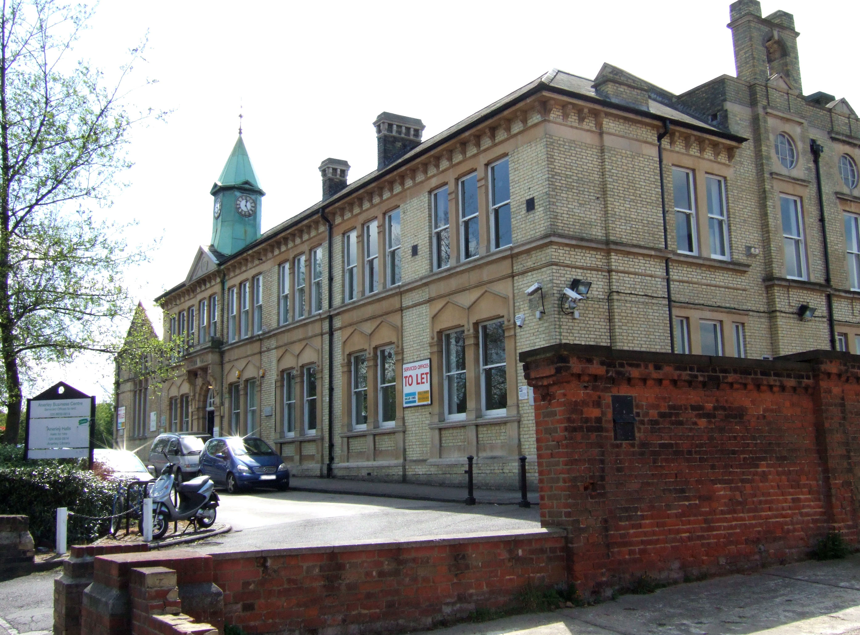
Anerley Town Hall

Anerley Town Hall is a municipal building in Anerley Road, Anerley, London. It is a locally listed building. == History == The building was commissioned...

Penge Common

Penge Common was an area of north east Surrey and north west Kent which now forms part of London, England; covering most of Penge, all of Anerley, and...

Nearby Amenities

Located within 500m of 51.408939,-0.065352
Traffic Signals
Traffic Signals Direction: forward
Lat/Long: 51.4088506/-0.0597064
Railway: switch
Lat/Long: 51.4070015/-0.0715567
Mini Roundabout
Direction: clockwise
Lat/Long: 51.4110837/-0.0594549
Turning Circle
Lat/Long: 51.4110146/-0.0681226
Noexit: yes
Lat/Long: 51.4132559/-0.0637307
Ref GB Tflcid: RWG204285
Traffic Calming: yes
Lat/Long: 51.4113936/-0.0627909
Ref GB Tflcid: RWG204283
Traffic Calming: yes
Lat/Long: 51.4113304/-0.0636554
Noexit: yes
Lat/Long: 51.4129746/-0.0625189
Mini Roundabout
Direction: clockwise
Lat/Long: 51.4057469/-0.0688506
Ref GB Tflcid: RWG204289
Traffic Calming: yes
Lat/Long: 51.4061449/-0.0678179
Post Box
Brand: Royal Mail
Brand Wikidata: Q638098
Collection Times: Mo-Fr 17:30; Sa 12:00
Drive Through: no
Operator: Royal Mail
Operator Wikidata: Q638098
Post Box Design: type_b
Post Box Type: pillar
Postal Code: SE20
Ref: SE20 2
Royal Cypher: EVIIR
Royal Cypher Wikidata: Q33102324
Source: survey
Lat/Long: 51.4066446/-0.0639806
Covered: no
Leisure: picnic_table
Lat/Long: 51.4079463/-0.0648136
Crossing
Button Operated: yes
Crossing: traffic_signals
Crossing Markings: dots
Tactile Paving: yes
Traffic Signals Sound: yes
Lat/Long: 51.4095293/-0.0622567
Bus Stop
Maple Road
Bus: yes
Local Ref: X
Naptan AtcoCode: 490009626AQ
Naptan Bearing: N
Naptan CommonName: Maple Road
Naptan Indicator: X
Naptan Street: ANERLEY ROAD
Naptan Verified: yes
Public Transport: platform
Ref: 76882
Shelter: yes
Source Ref: naptan
Lat/Long: 51.4093355/-0.0614443
Telephone
Booth: KX100
Covered: booth
Lat/Long: 51.406625/-0.064025
Bicycle Parking
Capacity: 12
Lat/Long: 51.412218/-0.0656662
Covered: no
Leisure: picnic_table
Lat/Long: 51.4079814/-0.0648598
The Royal Oak
Closed Amenity: pub
Lat/Long: 51.412446/-0.0634356
Bus Stop
Anerley Station
Bus: yes
Local Ref: F
Naptan AtcoCode: 490001007AD
Naptan Bearing: W
Naptan CommonName: Anerley
Naptan Indicator: AD
Naptan Street: ANERLEY STATION ROAD
Naptan Verified: yes
Public Transport: platform
Ref: 52327
Source Ref: naptan
Lat/Long: 51.4120397/-0.0655288
Bicycle Parking
Capacity: 12
Lat/Long: 51.4123869/-0.0655157
Ref GB Tflcid: RWG204279
Traffic Calming: yes
Lat/Long: 51.4123724/-0.0682821
Bus Stop
Anerley Road / Oak Grove Road
Bench: yes
Bin: no
Bus: yes
Lit: yes
Local Ref: K
Naptan AtcoCode: 490003317AJ
Naptan Bearing: W
Naptan CommonName: Anerley Road Oak Grove Road
Naptan Indicator: AJ
Naptan Verified: yes
Public Transport: platform
Ref: 58672
Shelter: yes
Source Ref: naptan
Tactile Paving: no
Lat/Long: 51.4089692/-0.0587258
Ref GB Tflcid: RWG204282
Traffic Calming: yes
Lat/Long: 51.4122291/-0.0634591
Noexit: yes
Lat/Long: 51.4119042/-0.063186
Ref GB Tflcid: RWG203244
Traffic Calming: hump
Lat/Long: 51.4124913/-0.0684581
Post Box
Brand: Royal Mail
Brand Wikidata: Q638098
Collection Times: Mo-Fr 17:30; Sa 12:00
Drive Through: no
Operator: Royal Mail
Operator Wikidata: Q638098
Post Box Design: type_a
Post Box Type: pillar
Ref: SE20 28
Royal Cypher: EIIR
Royal Cypher Wikidata: Q33102113
Source: survey
Lat/Long: 51.408566/-0.0672549
Recycling
Lat/Long: 51.4068541/-0.0672542
Post Box
Brand: Royal Mail
Brand Wikidata: Q638098
Collection Times: Mo-Fr 17:30; Sa 12:00
Drive Through: no
Operator: Royal Mail
Operator Wikidata: Q638098
Post Box Design: type_b
Post Box Type: pillar
Ref: SE20 25
Royal Cypher: EVIIR
Royal Cypher Wikidata: Q33102324
Source: survey
Lat/Long: 51.4063956/-0.0683836
Crossing
Button Operated: yes
Crossing: traffic_signals
Crossing Island: no
Crossing Ref: puffin
Tactile Paving: yes
Traffic Signals Sound: yes
Traffic Signals Vibration: yes
Lat/Long: 51.4065226/-0.0639621
Ref GB Tflcid: RWG204288
Traffic Calming: yes
Lat/Long: 51.4071396/-0.06522
Bus Stop
Samos Road
Bench: yes
Bin: no
Bus: yes
Local Ref: C
Naptan AtcoCode: 490011884AT
Naptan Bearing: E
Naptan CommonName: Samos Road
Naptan Indicator: AT
Naptan Street: CROYDON ROAD
Naptan Verified: no
Public Transport: platform
Ref: 77014
Shelter: no
Source Ref: naptan
Lat/Long: 51.4070451/-0.0629985
Library
Anerley Library
Addr City: London
Addr Housename: Anerley Town Hall
Addr Postcode: SE20 8BD
Addr Street: Anerley Road
Lat/Long: 51.4118519/-0.0673109
Post Box
Brand: Royal Mail
Brand Wikidata: Q638098
Collection Times: Mo-Fr 17:30; Sa 12:00
Drive Through: no
Operator: Royal Mail
Operator Wikidata: Q638098
Post Box Design: type_a
Post Box Type: pillar
Postal Code: SE20
Ref: SE20 12
Royal Cypher: GR
Royal Cypher Wikidata: Q33102273
Source: survey
Lat/Long: 51.4090799/-0.0587565
Telephone
Note: not BT
Lat/Long: 51.4090626/-0.0587924
Post Box
Brand: Royal Mail
Brand Wikidata: Q638098
Collection Times: Mo-Fr 17:30; Sa 12:00
Drive Through: no
Operator: Royal Mail
Operator Wikidata: Q638098
Post Box Design: type_a
Post Box Type: pillar
Postal Code: SE20
Ref: SE20 1
Royal Cypher: GR
Royal Cypher Wikidata: Q33102273
Source: survey
Lat/Long: 51.4121329/-0.0669716
Post Box
Brand: Royal Mail
Brand Wikidata: Q638098
Collection Times: Mo-Fr 17:30; Sa 12:00
Drive Through: no
Operator: Royal Mail
Operator Wikidata: Q638098
Post Box Design: type_a
Post Box Type: pillar
Postal Code: SE20
Ref: SE20 9
Royal Cypher: VR
Royal Cypher Wikidata: Q33102356
Source: survey
Lat/Long: 51.4094881/-0.0615587
Recycling
Recycling Cans: yes
Recycling Cardboard: yes
Recycling Clothes: yes
Recycling Glass Bottles: yes
Recycling Paper: yes
Recycling Plastic Bottles: yes
Recycling Shoes: yes
Recycling Type: container
Lat/Long: 51.4062753/-0.0647074
Wheelchair: yes
Lat/Long: 51.4097816/-0.0613429
Bus Stop
Anerley Road / Anerley Station
Bench: yes
Bin: yes
Bus: yes
Lit: yes
Local Ref: C
Naptan AtcoCode: 490001007AA
Naptan Bearing: S
Naptan CommonName: Anerley
Naptan Indicator: Stop AA
Naptan Street: ANERLEY ROAD
Naptan Verified: yes
Public Transport: platform
Ref: 49901
Shelter: yes
Source Ref: naptan
Tactile Paving: no
Lat/Long: 51.4120417/-0.0668161
Bus Stop
Anerley Road / Anerley Station
Bench: yes
Bin: yes
Bus: yes
Lit: yes
Local Ref: H
Naptan AtcoCode: 490001007AB
Naptan Bearing: N
Naptan CommonName: Anerley
Naptan Indicator: Stop AB
Naptan Street: ANERLEY ROAD
Naptan Verified: yes
Public Transport: platform
Ref: 71640
Shelter: yes
Source Ref: naptan
Tactile Paving: no
Lat/Long: 51.4118437/-0.0667868
Bus Stop
Jasmine Grove
Bus: yes
Local Ref: E
Naptan AtcoCode: 490001007AE
Naptan Bearing: E
Naptan CommonName: Anerley
Naptan Indicator: AE
Naptan Street: ANERLEY STATION ROAD
Naptan Verified: yes
Public Transport: platform
Ref: 71619
Source Ref: naptan
Lat/Long: 51.4124361/-0.0643557
Bus Stop
Anerley Station
Bus: yes
Local Ref: G
Naptan AtcoCode: 490001007E
Naptan Bearing: E
Naptan CommonName: Anerley
Naptan Indicator: AF
Naptan Street: ANERLEY STATION ROAD
Naptan Verified: yes
Public Transport: platform
Ref: 77402
Source Ref: naptan
Wheelchair: yes
Lat/Long: 51.4119144/-0.0658316
Bus Stop
Anerley Road / Croydon Road
Bench: yes
Bin: yes
Bus: yes
Lit: yes
Local Ref: V
Naptan AtcoCode: 490003317AH
Naptan Bearing: S
Naptan CommonName: Anerley Road Oak Grove Road
Naptan Indicator: AH
Naptan Street: ANERLEY ROAD
Naptan Verified: yes
Public Transport: platform
Ref: 54259
Shelter: yes
Source Ref: naptan
Tactile Paving: no
Lat/Long: 51.4091801/-0.0600091
Bus Stop
Anerley Road / Oak Grove Road
Bench: yes
Bus: yes
Local Ref: E
Naptan AtcoCode: 490003317AK
Naptan Bearing: E
Naptan CommonName: Anerley Road Oak Grove Road
Naptan Indicator: AK
Naptan Verified: yes
Public Transport: platform
Ref: 53831
Source Ref: naptan
Lat/Long: 51.4090445/-0.0588664
Bus Stop
Croydon Road / Elmers End Road
Bench: yes
Bin: yes
Bus: yes
Local Ref: D
Naptan AtcoCode: 490003317AP
Naptan Bearing: W
Naptan CommonName: Anerley Road Oak Grove Road
Naptan Indicator: Stop AP
Naptan Street: CROYDON ROAD
Naptan Verified: yes
Public Transport: platform
Ref: 72917
Shelter: yes
Source Ref: naptan
Tactile Paving: no
Lat/Long: 51.4083398/-0.0603292
Bus Stop
Anerley / The Mitre
Bench: yes
Bin: yes
Bus: yes
Local Ref: M
Naptan AtcoCode: 490003318AV
Naptan Bearing: W
Naptan CommonName: Anerley The Mitre
Naptan Indicator: AV
Naptan Street: CROYDON ROAD
Naptan Verified: no
Public Transport: platform
Ref: 74815
Shelter: no
Source Ref: naptan
Tactile Paving: no
Lat/Long: 51.406716/-0.0633934
Bus Stop
Anerley / The Mitre
Bus: yes
Local Ref: B
Naptan AtcoCode: 490003318E
Naptan Bearing: E
Naptan CommonName: Anerley The Mitre
Naptan Street: CROYDON ROAD
Naptan Verified: no
Public Transport: platform
Ref: 59401
Shelter: yes
Source Ref: naptan
Lat/Long: 51.4063011/-0.0645636
Bus Stop
Anerley Park / Anerley Road
Bench: no
Bin: no
Bus: yes
Lit: no
Local Ref: R
Naptan AtcoCode: 490003319S
Naptan Bearing: S
Naptan CommonName: Anerley Park
Naptan Indicator: Stop
Naptan Verified: yes
Public Transport: platform
Ref: 48559
Shelter: no
Source Ref: naptan
Tactile Paving: no
Lat/Long: 51.4128497/-0.0678883
Bus Stop
Betts Way
Bus: yes
Local Ref: U
Naptan AtcoCode: 490003955AG
Naptan Bearing: E
Naptan CommonName: Betts Way
Naptan Indicator: AG
Naptan Street: ANERLEY ROAD
Naptan Verified: yes
Public Transport: platform
Ref: 47439
Source Ref: naptan
Lat/Long: 51.4097116/-0.0629943
Bus Stop
Croydon Road
Bench: no
Bin: no
Bus: yes
Lit: yes
Local Ref: W
Naptan AtcoCode: 490005862AL
Naptan Bearing: N
Naptan CommonName: Croydon Road Robin Hood
Naptan Indicator: AL
Naptan Street: ELMERS END ROAD
Naptan Verified: no
Public Transport: platform
Shelter: no
Tactile Paving: no
Timetable: yes
Lat/Long: 51.4082167/-0.0593193
Bus Stop
Derwent Road
Bench: yes
Local Ref: N
Naptan AtcoCode: 490006061W
Naptan Bearing: N
Naptan CommonName: Derwent Road
Naptan Street: CROYDON ROAD
Naptan Verified: no
Public Transport: platform
Shelter: yes
Lat/Long: 51.4054495/-0.065894
Bus Stop
Selby Road
Bench: yes
Bin: yes
Bus: yes
Local Ref: A
Naptan AtcoCode: 490011984E
Naptan Bearing: N
Naptan CommonName: Selby Road
Naptan Street: CROYDON ROAD
Naptan Verified: no
Public Transport: platform
Shelter: yes
Tactile Paving: no
Lat/Long: 51.4048919/-0.0671773
Bus Stop
Seymour Villas
Bench: yes
Bin: yes
Bus: yes
Local Ref: Y
Naptan AtcoCode: 490012015N
Naptan Bearing: N
Naptan CommonName: Seymour Villas
Naptan Indicator: Stop AS
Naptan Verified: no
Public Transport: platform
Ref: 49082
Shelter: yes
Source Ref: naptan
Tactile Paving: no
Lat/Long: 51.41008/-0.0643396
Bus Stop
Seymour Villas
Bench: yes
Bin: no
Bus: yes
Local Ref: D
Naptan AtcoCode: 490012015S
Naptan Bearing: S
Naptan CommonName: Seymour Villas
Naptan Indicator: Stop AC
Naptan Street: ANERLEY ROAD
Naptan Verified: yes
Public Transport: platform
Ref: 51525
Shelter: yes
Source Ref: naptan
Tactile Paving: no
Lat/Long: 51.4109496/-0.0652773
Bus Stop
Anerley Road / Worbeck Road
Bench: yes
Bin: yes
Bus: yes
Local Ref: L
Naptan AtcoCode: 490015130AN
Naptan Bearing: W
Naptan CommonName: Anerley Road Worbreck Road
Naptan Indicator: AN
Naptan Street: CROYDON ROAD
Naptan Verified: yes
Public Transport: platform
Ref: 49596
Shelter: yes
Source Ref: naptan
Tactile Paving: no
Lat/Long: 51.4080696/-0.0605722
Bicycle Parking
Bicycle Parking: stands
Capacity: 8
Covered: yes
Lat/Long: 51.4086826/-0.0592957
Crossing
Button Operated: yes
Crossing: traffic_signals
Crossing Island: no
Crossing Ref: puffin
Tactile Paving: yes
Traffic Signals Sound: yes
Traffic Signals Vibration: yes
Lat/Long: 51.4122347/-0.0672176
Entrance: yes
Lat/Long: 51.4122779/-0.0670876
Anerley
Place: suburb
Wikidata: Q2253734
Lat/Long: 51.4088267/-0.0611263
Ref GB Tflcid: RWG204287
Traffic Calming: yes
Lat/Long: 51.4071634/-0.0651709
Recycling
Recycling Clothes: yes
Recycling Shoes: yes
Recycling Type: container
Lat/Long: 51.4065898/-0.0640927
Entrance: yes
Lat/Long: 51.4074419/-0.0681937
Entrance: yes
Lat/Long: 51.4081897/-0.0677811
Generator Method: photovoltaic
Generator Output Electricity: yes
Generator Source: solar
Generator Type: solar_photovoltaic_panel
Power: generator
Lat/Long: 51.4060916/-0.0657335
Telephone
Booth: KX100
Covered: booth
Lat/Long: 51.4060193/-0.065116
Generator Method: photovoltaic
Generator Output Electricity: yes
Generator Source: solar
Generator Type: solar_photovoltaic_panel
Power: generator
Lat/Long: 51.4061915/-0.0652913
Traffic Signals
Traffic Signals Direction: backward
Lat/Long: 51.4087686/-0.0592969
Cafe
Rosie Lee's
Addr Housenumber: 147
Addr Street: Anerley Road
Lat/Long: 51.4112761/-0.0656721
Bicycle Parking
Bicycle Parking: stands
Capacity: 8
Check Date Capacity: 2021-02-27
Covered: no
Lat/Long: 51.411403/-0.0659813
Crossing
Button Operated: yes
Crossing: traffic_signals
Crossing Island: no
Crossing Ref: pelican
Tactile Paving: yes
Traffic Signals Sound: yes
Traffic Signals Vibration: yes
Lat/Long: 51.408721/-0.0593946
Anerley News Food & Wine
Addr City: London
Addr Housenumber: 123
Addr Postcode: SE20 8AJ
Addr Street: Anerley Road
Addr Suburb: Anerley
Contact Email: anerleynews@gmail.com
Contact Website: https://anerley-news-food-wine.ueniweb.com/
Fhrs Id: 1052472
Opening Hours: Mo-Su 07:00-19:00
Payment Cash: yes
Payment Credit Cards: yes
Payment Debit Cards: yes
Payment Mastercard: yes
Payment Visa: yes
Shop: convenience
Source Addr: FHRS Open Data
Lat/Long: 51.4113547/-0.0657746
Hudson Dry Cleaners
Shop: dry_cleaning
Lat/Long: 51.4111604/-0.0655627
Crossing
Button Operated: yes
Crossing: traffic_signals
Crossing Island: no
Crossing Ref: pelican
Tactile Paving: yes
Traffic Signals Sound: yes
Traffic Signals Vibration: yes
Lat/Long: 51.4085838/-0.0596861
Cycleway: asl
Direction: backward
Lat/Long: 51.4085054/-0.0594422
Crossing
Button Operated: yes
Crossing: traffic_signals
Crossing Island: yes
Crossing Ref: pelican
Tactile Paving: yes
Traffic Signals Sound: yes
Traffic Signals Vibration: yes
Lat/Long: 51.4087572/-0.0596232
Crossing
Button Operated: yes
Crossing: traffic_signals
Crossing Island: no
Crossing Ref: pelican
Tactile Paving: yes
Traffic Signals Sound: yes
Traffic Signals Vibration: yes
Lat/Long: 51.40855/-0.0594731
Fast Food
Tony's Lunch Box Sandwich Bar
Addr City: London
Addr Housenumber: 2
Addr Postcode: SE20 8PT
Addr Street: Anerley Station Road
Addr Suburb: Anerley
Cuisine: sandwich
Fhrs Id: 357953
Source Addr: FHRS Open Data
Lat/Long: 51.41157/-0.0658614
Safestore
Addr City: Anerley
Addr Housenumber: 1
Addr Street: Oakfield Road
Brand: Safestore
Brand Wikidata: Q20713915
Phone: +44 20 8659 0700
Shop: storage_rental
Website: https://www.safestore.co.uk/storage/london/crystal-palace/
Lat/Long: 51.4127416/-0.0642812
Anerley
Naptan AtcoCode: 9100ANERLEY
Network: London Overground
Network Wikidata: Q746021
Old Name: Anerley Bridge
Operator: Transport for London
Operator Wikidata: Q682520
Public Transport: station
Railway: station
Ref Crs: ANZ
Source Network: sign
Tfl Travelzone: 4
Train: yes
Wheelchair: limited
Wheelchair Description: Step-free from streets to platforms on both sides. Steps and footbridge between platforms.
Wikidata: Q2012789
Wikipedia: en:Anerley railway station
Lat/Long: 51.4125891/-0.0655796
Clinic
Park Practice @ Oaks Medical Centre
Healthcare: clinic
Lat/Long: 51.4131645/-0.0635999
Bench
Backrest: yes
Lat/Long: 51.4129835/-0.0680651
Bicycle Parking
Bicycle Parking: stands
Capacity: 4
Covered: no
Lat/Long: 51.4121849/-0.0670936
Bench
Backrest: yes
Lat/Long: 51.4120564/-0.0658952
Shelter
Shelter Type: public_transport
Lat/Long: 51.4127291/-0.0655725
Vending Machine
Vending: public_transport_tickets
Lat/Long: 51.412043/-0.0657842
Doctors
Anerley Surgery
Check Date: 2023-08-26
Healthcare: doctor
Lat/Long: 51.4090535/-0.0606243
Bromley Up Junction
Railway: junction
Lat/Long: 51.4070148/-0.0715278
Anerley
Public Transport: stop_position
Railway: stop
Ref: 1
Train: yes
Lat/Long: 51.413204/-0.065047
Anerley
Public Transport: stop_position
Railway: stop
Ref: 2
Train: yes
Lat/Long: 51.41177/-0.0662061
Kamsons Pharmacy
Addr City: London
Addr Housename: Oaks Park Medical Centre
Addr Housenumber: 17
Addr Postcode: SE20 8QA
Addr Street: Oakfield Road
Fhrs Id: 1222303
Shop: chemist
Source Addr: FHRS Open Data
Lat/Long: 51.413224/-0.0633552
Entrance: yes
Lat/Long: 51.4045584/-0.0666534
Entrance: yes
Lat/Long: 51.4046663/-0.0664538
Telephone
Booth: KX100
Covered: booth
Not Operator Wikidata: Q593786
Operator: British Telecom
Lat/Long: 51.4090746/-0.0587702
Telephone
Note: not BT
Lat/Long: 51.4090577/-0.0588036
Dentist
O'Connor and Associates Dental Surgery
Healthcare: dentist
Lat/Long: 51.4110433/-0.0654154
Bicycle Parking
Access: yes
Bicycle Parking: stands
Capacity: 4
Covered: no
Fee: no
Lat/Long: 51.4099058/-0.0642347
Bicycle Parking
Bicycle Parking: stands
Capacity: 4
Covered: no
Ref GB Tflcid: RWG204333
Lat/Long: 51.4117413/-0.0667492
Bicycle Parking
Access: private
Bicycle Parking: shed
Capacity: 12
Covered: yes
Operator: Cyclehoop Rentals
Ref GB Tflcid: RWG204329
Lat/Long: 51.4129108/-0.0661837
Bicycle Parking
Access: private
Bicycle Parking: shed
Capacity: 6
Covered: yes
On Carriageway: yes
Operator: Cyclehoop Rentals
Ref GB Tflcid: RWG204412
Lat/Long: 51.4060186/-0.0609467
Bicycle Parking
Bicycle Lock: bring_own
Bicycle Parking: lockers
Capacity: 2
Ref GB Tflcid: RWG204334
Lat/Long: 51.4107404/-0.0676612
Bicycle Parking
Bicycle Parking: stands
Capacity: 10
Covered: yes
Ref GB Tflcid: RWG204462
Lat/Long: 51.4059428/-0.0667912
Ref GB Tflcid: RWG203116
Traffic Calming: hump
Lat/Long: 51.4118295/-0.0669342
Building: service
Operator: UK Power Networks
Operator Wikidata: Q7864927
Power: substation
Substation: minor_distribution
Lat/Long: 51.4067719/-0.0667767
Building: service
Operator: UK Power Networks
Operator Wikidata: Q7864927
Power: substation
Substation: minor_distribution
Lat/Long: 51.405311/-0.06508
Traffic Signals
Traffic Signals Direction: backward
Lat/Long: 51.4084717/-0.0594162
Traffic Signals
Traffic Signals Direction: forward
Lat/Long: 51.4085335/-0.0597849
Drinking Water
Bottle: yes
Fee: no
Fountain: bubbler
Wheelchair: yes
Lat/Long: 51.4108194/-0.0693863
Bench: yes
Covered: no
Leisure: picnic_table
Lat/Long: 51.4112536/-0.0693296
Bench: yes
Covered: no
Leisure: picnic_table
Lat/Long: 51.4112983/-0.0692907
Bench: yes
Covered: no
Leisure: picnic_table
Lat/Long: 51.4113473/-0.0691901
Bicycle Parking
Scooter Rack
Bicycle Parking: rack
Capacity: 25
Covered: no
Lat/Long: 51.4112845/-0.0691257
Bench
Lat/Long: 51.4088194/-0.0631522
Bench
Lat/Long: 51.4087792/-0.0629913
Baby: no
Capacity: 4
Playground: swing
Lat/Long: 51.4082472/-0.0643921
Baby: yes
Capacity: 4
Playground: swing
Lat/Long: 51.4080778/-0.0644518
Playground: seesaw
Lat/Long: 51.4081489/-0.0645329
Playground: roundabout
Lat/Long: 51.4082129/-0.064486
Playground: slide
Lat/Long: 51.4080937/-0.0643364
Playground: climbingframe
Playground Theme: tractor
Lat/Long: 51.4081656/-0.0642748
Playground: roundabout
Lat/Long: 51.4082334/-0.0641889
Playground: seesaw
Lat/Long: 51.4082978/-0.0642627
Playground: seesaw
Lat/Long: 51.4082802/-0.0642265
Man Made: pump
Substance: water
Lat/Long: 51.4102763/-0.0647314
Undercroft Carpark
Access: private
Door: automatic
Entrance: garage
Wheelchair: yes
Lat/Long: 51.4120211/-0.0702231
Bench
Backrest: no
Colour: brown
Material: wood
Seats: 8
Lat/Long: 51.4103191/-0.0678002
Bench
Backrest: no
Colour: brown
Material: wood
Seats: 8
Lat/Long: 51.4105407/-0.0682247
Bench
Backrest: no
Colour: brown
Material: wood
Seats: 8
Lat/Long: 51.4105621/-0.0682441
Waste Basket
Waste: dog_excrement
Lat/Long: 51.4117648/-0.0690343
Waste Basket
Colour: Green
Material: metal
Waste: litter
Lat/Long: 51.4116506/-0.0689015
Playground: swing
Lat/Long: 51.4099144/-0.0678366
Playground: mud
Lat/Long: 51.4111778/-0.0683062
Playground: slide
Lat/Long: 51.4113562/-0.0685258
Playground: water
Lat/Long: 51.4108996/-0.0685578
Playground: water
Lat/Long: 51.4110437/-0.0684297
Playground: balancebeam
Lat/Long: 51.4108226/-0.0689158
Playground: balancebeam
Lat/Long: 51.4105465/-0.0688391
Charging Station
Amperage: 16
Authentication Membership Card: yes
Capacity: 1
Fee: yes
Motorcar: yes
Opening Hours: 24/7
Operator: Rolec
Voltage: 230
Lat/Long: 51.411496/-0.0710913
Charging Station
Amperage: 16
Authentication Membership Card: yes
Capacity: 1
Fee: yes
Motorcar: yes
Opening Hours: 24/7
Operator: Rolec
Voltage: 230
Lat/Long: 51.4114696/-0.0711429
Bench
Backrest: yes
Lat/Long: 51.4112421/-0.0707238
Bench
Backrest: yes
Lat/Long: 51.4113024/-0.070805
Playground: climbingframe
Lat/Long: 51.4113219/-0.0707536
Playground: springy
Lat/Long: 51.4112784/-0.0707553
Playground: springy
Lat/Long: 51.4112709/-0.070689
Playground: seesaw
Lat/Long: 51.411312/-0.0706833
Access: customers
Door: hinged
Entrance: yes
Wheelchair: yes
Lat/Long: 51.4118054/-0.0639892
Noexit: yes
Lat/Long: 51.4117679/-0.0633149
Crossing
Crossing: unmarked
Crossing Island: yes
Crossing Markings: no
Tactile Paving: yes
Lat/Long: 51.4095603/-0.0618839
Direction: both
Surface: asphalt
Traffic Calming: chicane
Lat/Long: 51.4102641/-0.0607252
Waste Basket
Lat/Long: 51.408981/-0.0674609
The data included in this document is from www.openstreetmap.org. The data is made available under ODbL.

Have you been to Anerley?

Leave your review of Anerley below (or comments, questions and feedback).