Westaways Plantation

Wood, Forest in Cornwall

England

Westaways Plantation

View W to Portwrinkle from SW Coast Path
View W to Portwrinkle from SW Coast Path Credit: Colin Park

Westaways Plantation is a captivating woodland area located in Cornwall, England. Situated near the picturesque village of Wood, this plantation is a haven for nature enthusiasts and those seeking tranquility amidst the lush greenery. Covering an expansive area, the plantation is a thriving ecosystem that supports a diverse range of flora and fauna.

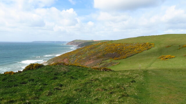
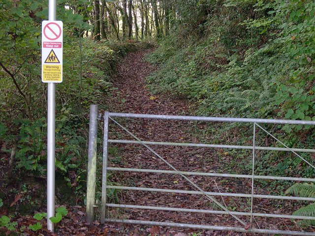
The forest is predominantly composed of native British tree species, including oak, beech, and ash, which provide a dense canopy that blankets the plantation. This creates a shaded and cool atmosphere, perfect for leisurely walks or picnics in the summer months. The woodland floor is adorned with a carpet of vibrant wildflowers, adding splashes of color to the landscape.

The plantation is home to a variety of wildlife, making it an ideal destination for birdwatchers and animal lovers. Many different bird species can be spotted here, including woodpeckers, owls, and various songbirds. Squirrels and rabbits are also commonly seen scurrying amongst the trees, while occasionally, lucky visitors may catch a glimpse of a deer or fox.

Westaways Plantation offers several well-maintained trails that wind their way through the forest, allowing visitors to explore its beauty at their own pace. These paths are suitable for all ages and fitness levels, ensuring that everyone can enjoy the plantation's tranquil ambiance.

For those seeking a peaceful retreat in nature, Westaways Plantation in Cornwall is a must-visit destination. Whether it's to admire the diverse array of trees, spot wildlife, or simply enjoy a moment of serenity, this woodland oasis offers an unforgettable experience for all who venture into its embrace.

If you have any feedback on the listing, please let us know in the comments section below.

Westaways Plantation Images

Images are sourced within 2km of 50.365623/-4.2889576 or Grid Reference SX3754. Thanks to Geograph Open Source API. All images are credited.

View W to Portwrinkle from SW Coast Path
On SW Coast Path - view W above Trethill Cliffs
Tregantle Fort near Antony Tregantle Fort is one of several forts surrounding Plymouth that were built as a result of a decision in Lord Palmerston's premiership to deter the French from attacking naval bases on the Channel coast. The fort was originally designed by Captain William Crossman, with later modifications by Captain (later Maj General) Edmund Frederick Du Cane. Construction commenced in 1859 and was completed in 1865. When originally designed it had provision for 35 large guns. By 1893 the guns consisted of five RBL 7 inch Armstrong guns and nineteen RML 64-pounders, together with a number of 32 Pounder Smooth Bore Breech Loading guns. Early in the 1900s it became an infantry battalion headquarters with 14 officers and 423 other ranks, and from 1903 was used for rifle training. Tregantle is infamous within the armed forces because many of the rifle ranges located there slope steeply down towards the sea. These ranges are still in use, primarily by personnel located at HMS Raleigh. Tregantle was vacated after World War I until 1938, when it was used as the Territorial Army Passive Air Defence School. During World War II it was used first as the Army Gas School and from 1942 as US Army accommodation. (source Wikipedia)
Tregantle Fort near Antony
Tregantle Fort is one of several forts surrounding Plymouth that were built as a result of a decision in Lord Palmerston's premiership to deter the French from attacking naval bases on the Channel coast. The fort was originally designed by Captain William Crossman, with later modifications by Captain (later Maj General) Edmund Frederick Du Cane. Construction commenced in 1859 and was completed in 1865. When originally designed it had provision for 35 large guns. By 1893 the guns consisted of five RBL 7 inch Armstrong guns and nineteen RML 64-pounders, together with a number of 32 Pounder Smooth Bore Breech Loading guns. Early in the 1900s it became an infantry battalion headquarters with 14 officers and 423 other ranks, and from 1903 was used for rifle training. Tregantle is infamous within the armed forces because many of the rifle ranges located there slope steeply down towards the sea. These ranges are still in use, primarily by personnel located at HMS Raleigh. Tregantle was vacated after World War I until 1938, when it was used as the Territorial Army Passive Air Defence School. During World War II it was used first as the Army Gas School and from 1942 as US Army accommodation. (source Wikipedia)
Finneygook Beach, Portwrinkle Looking Seaward (South) from the rockpools.
Finneygook Beach, Portwrinkle
Looking Seaward (South) from the rockpools.
Portwrinkle This photograph of the small coastal village of Portwrinkle was taken from the hillside adjacent to Finnygook lane. The photograph shows the 20th century development of the village including a large hotel.  The area of Portwrinkle which formed the original fishing village is at the western end of the village, just out of sight on this shot.
Portwrinkle
This photograph of the small coastal village of Portwrinkle was taken from the hillside adjacent to Finnygook lane. The photograph shows the 20th century development of the village including a large hotel. The area of Portwrinkle which formed the original fishing village is at the western end of the village, just out of sight on this shot.
Tregantle Rifle Range and The Kodima This photograph looks out to sea over one of the rifle ranges at Tregantle Fort, although at this time it looks more like a timber yard.  The ship beached in the bay is the Kodima which was stranded in heavy seas on 2nd February 2002.  This photograph was taken 2 weeks later just before it was refloated.  The ship was carrying a cargo of timber planks, much of which was washed up on local beaches and subsequently "liberated" by local people indulging in one of the oldest Cornish Traditions.  Officials protested that this activity was against the law  and generally not cricket but nobody paid much attention.  A local pub put out a sign saying "Wreckers welcome".
Tregantle Rifle Range and The Kodima
This photograph looks out to sea over one of the rifle ranges at Tregantle Fort, although at this time it looks more like a timber yard. The ship beached in the bay is the Kodima which was stranded in heavy seas on 2nd February 2002. This photograph was taken 2 weeks later just before it was refloated. The ship was carrying a cargo of timber planks, much of which was washed up on local beaches and subsequently "liberated" by local people indulging in one of the oldest Cornish Traditions. Officials protested that this activity was against the law and generally not cricket but nobody paid much attention. A local pub put out a sign saying "Wreckers welcome".
Crafthole Village Crafthole is a village on the hilltop above Portwrinkle. The picture shows part of the old village centre although there are many more 20th century houses in the village.
Crafthole Village
Crafthole is a village on the hilltop above Portwrinkle. The picture shows part of the old village centre although there are many more 20th century houses in the village.
Valley to the north of Trewrickle Farm.
Old farm buildings at Tredrossel Conversions are taking place, the farthest building has been converted into cottages.
Old farm buildings at Tredrossel
Conversions are taking place, the farthest building has been converted into cottages.
Sheviock Looking east towards the village of Sheviock from Horsepool Road.  The freshwater lake in the foreground has been artificially created.
Sheviock
Looking east towards the village of Sheviock from Horsepool Road. The freshwater lake in the foreground has been artificially created.
Sheviock A view of the village from the eastern side.  The church spire on the right is the Parish Church of St Mary, Sheviock.  While this may look an idyllic scene, Sheviock is one of those unfortunate villages which is split by a fast main road.  Although some of the traffic actually obeys the 40mph speed limit, this does not really help to make it either peaceful or safe.
Sheviock
A view of the village from the eastern side. The church spire on the right is the Parish Church of St Mary, Sheviock. While this may look an idyllic scene, Sheviock is one of those unfortunate villages which is split by a fast main road. Although some of the traffic actually obeys the 40mph speed limit, this does not really help to make it either peaceful or safe.
The A374 east of Sheviock This stretch of road between the villages of Antony and Polbathic cuts through the low-lying mainly wooded countryside along the south side of Lynher River estuary.  Its open curves and good cambers make it a favourite with motor cyclists.
The A374 east of Sheviock
This stretch of road between the villages of Antony and Polbathic cuts through the low-lying mainly wooded countryside along the south side of Lynher River estuary. Its open curves and good cambers make it a favourite with motor cyclists.
Not the way into Wacker Woods While the footpath looks inviting, the sign warns that it leads into a military training area and that entry is forbidden.
Not the way into Wacker Woods
While the footpath looks inviting, the sign warns that it leads into a military training area and that entry is forbidden.
Wacker Quay and Warren Point Looking over the old quayside and across the entrance to the tidal creek called Wacker Lake to the woodlands at Warren Point.  Wacker Quay used to be where ammunition and other goods were brought in for the military fortifications of Scraesdon Fort and Tregantle Fort.  They were taken up to the forts on a railway line which started here but has long since disappeared.
Wacker Quay and Warren Point
Looking over the old quayside and across the entrance to the tidal creek called Wacker Lake to the woodlands at Warren Point. Wacker Quay used to be where ammunition and other goods were brought in for the military fortifications of Scraesdon Fort and Tregantle Fort. They were taken up to the forts on a railway line which started here but has long since disappeared.
Houses on the Seafront Road This is at the western end of Portwrinkle, the site of the old village.  The white house in the foreground called "Smuggler's Cottage" is probably the oldest house in the village.  It has a date mark of 1795 on the front.  In the 17th and early 18th century it is likely that almost all male residents of the village took part in smuggling from time to time as it was one way to supplement the meagre income from the pilchard fishery.
Houses on the Seafront Road
This is at the western end of Portwrinkle, the site of the old village. The white house in the foreground called "Smuggler's Cottage" is probably the oldest house in the village. It has a date mark of 1795 on the front. In the 17th and early 18th century it is likely that almost all male residents of the village took part in smuggling from time to time as it was one way to supplement the meagre income from the pilchard fishery.
The old fish cellars, Portwrinkle This derelict building in Portwrinkle used to be the Pilchard processing plant.  Pilchards are the reason that Portwrinkle exists.  The village was set up by the local landowners, the Carew-Pole family in order to take advantage of the pilchard fisheries.  The shoals of pilchard would be spotted by a look-out on the hill above the village who would guide the boats into the shoal by semaphore.  Pilchards were salted and pressed in the cellar and the oil which drained off was an important by-product.  The fish could then be boxed and sent away for sale.  In the mid 19th century with the pilchard fisheries beginning to decline, local fisherman bought the fishery from the landowner by forming a co-operative which they called "The Poor Man's Endeavour", quite a provocative name for the time.  This continued until the First World War.

The last factory producing traditionally processed Cornish pilchards operated in Newlyn and closed in October 2005.
The old fish cellars, Portwrinkle
This derelict building in Portwrinkle used to be the Pilchard processing plant. Pilchards are the reason that Portwrinkle exists. The village was set up by the local landowners, the Carew-Pole family in order to take advantage of the pilchard fisheries. The shoals of pilchard would be spotted by a look-out on the hill above the village who would guide the boats into the shoal by semaphore. Pilchards were salted and pressed in the cellar and the oil which drained off was an important by-product. The fish could then be boxed and sent away for sale. In the mid 19th century with the pilchard fisheries beginning to decline, local fisherman bought the fishery from the landowner by forming a co-operative which they called "The Poor Man's Endeavour", quite a provocative name for the time. This continued until the First World War. The last factory producing traditionally processed Cornish pilchards operated in Newlyn and closed in October 2005.
The Boathouse, Portwrinkle This is an old building going back to at least the 19th century. It is situated at the top of the slipway and, when this photograph was taken, was still performing exactly the duties for which it was intended.  In the 19th century the fishermen of Portwrinkle bought out the fishery from the local landowner by forming a co-operative called "The Poor Man's Endeavour", quite a radical name for the time.  I like to think that they also recognised there was an element of black humour in the name (hint: shorten the last word).  They were photographed standing in front of this boathouse in around 1880.
The Boathouse, Portwrinkle
This is an old building going back to at least the 19th century. It is situated at the top of the slipway and, when this photograph was taken, was still performing exactly the duties for which it was intended. In the 19th century the fishermen of Portwrinkle bought out the fishery from the local landowner by forming a co-operative called "The Poor Man's Endeavour", quite a radical name for the time. I like to think that they also recognised there was an element of black humour in the name (hint: shorten the last word). They were photographed standing in front of this boathouse in around 1880.
Golf Course near Crafthole Looking over part of a golf course between Crafthole and the sea cliffs.
Golf Course near Crafthole
Looking over part of a golf course between Crafthole and the sea cliffs.
Show me another place!

Westaways Plantation is located at Grid Ref: SX3754 (Lat: 50.365623, Lng: -4.2889576)

Unitary Authority: Cornwall

Police Authority: Devon and Cornwall

What 3 Words

///friction.gratitude.inferior. Near Millbrook, Cornwall

Related Wikis

Crafthole

Crafthole is a village in the parish of Sheviock, in southeast Cornwall, England, UK. The village has a pub (Finnygook Inn), Post Office, shop, Methodist...

Sheviock

Sheviock (Cornish: Seviek, meaning strawberry bed) is a coastal civil parish and a hamlet in south-east Cornwall, England, United Kingdom. The parish is...

Portwrinkle

Portwrinkle (Cornish: Porthwykkel) is a small coastal village in south-east Cornwall, England, United Kingdom. It is at the western end of Whitsand Bay...
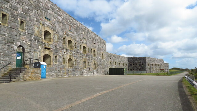
Tregantle Fort

Tregantle Fort in south east Cornwall is one of several forts surrounding Plymouth that were built as a result of a decision in Lord Palmerston's premiership...

Nearby Amenities

Located within 500m of 50.365623,-4.2889576
Power: pole
Lat/Long: 50.3657582/-4.2837507
Power: pole
Lat/Long: 50.3658951/-4.2845231
Power: pole
Lat/Long: 50.3660491/-4.2854458
Power: pole
Lat/Long: 50.3661928/-4.2861593
Power: pole
Lat/Long: 50.3663827/-4.2873099
Power: pole
Lat/Long: 50.3671526/-4.2914057
Power: pole
Lat/Long: 50.3676334/-4.2941093
Power: pole
Lat/Long: 50.3649814/-4.2827261
Power: pole
Lat/Long: 50.3652329/-4.2836702
Power: pole
Lat/Long: 50.3658917/-4.286457
Power: pole
Lat/Long: 50.3661449/-4.2875433
Power: pole
Lat/Long: 50.3666034/-4.2910275
Power: pole
Lat/Long: 50.3667488/-4.2921084
Power: pole
Lat/Long: 50.3670345/-4.2942381
Generator Method: photovoltaic
Generator Output Electricity: yes
Generator Source: solar
Generator Type: solar_photovoltaic_panel
Location: roof
Power: generator
Lat/Long: 50.3645288/-4.2929637
Generator Method: photovoltaic
Generator Output Electricity: yes
Generator Source: solar
Generator Type: solar_photovoltaic_panel
Location: roof
Power: generator
Lat/Long: 50.3645802/-4.2928544
WW2 Pillbox
Building: bunker
Bunker Type: pillbox
Military: bunker
Lat/Long: 50.3625393/-4.2901082
The data included in this document is from www.openstreetmap.org. The data is made available under ODbL.

Have you been to Westaways Plantation?

Leave your review of Westaways Plantation below (or comments, questions and feedback).