Burnside of Eslie Plantation

Wood, Forest in Kincardineshire

Scotland

Burnside of Eslie Plantation

Mains of Thornton farm house Originally called West Mains of Thornton 
as per 1863 survey OS map <span class="nowrap"><a title="http://maps.nls.uk/os/6inch/view/?sid=74427609" rel="nofollow ugc noopener" href="http://maps.nls.uk/os/6inch/view/?sid=74427609">Link</a><img style="margin-left:2px;" alt="External link" title="External link - shift click to open in new window" src="https://s1.geograph.org.uk/img/external.png" width="10" height="10"/></span>
Mains of Thornton farm house Credit: Richard Holliday

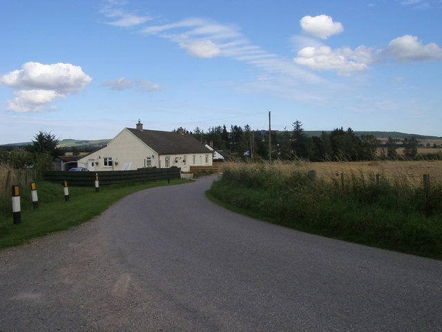
Burnside of Eslie Plantation is a picturesque woodland area located in Kincardineshire, Scotland. This beautiful forest is known for its natural beauty, diverse wildlife, and historical significance.

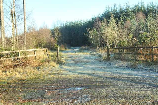
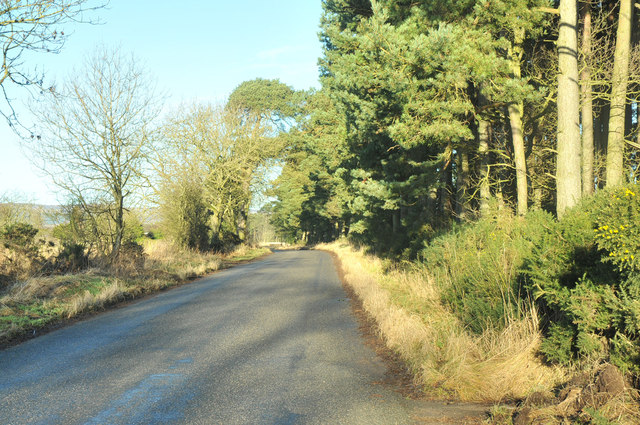
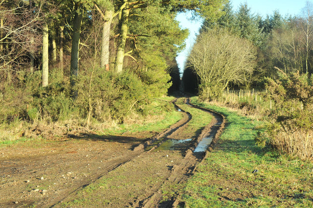
Covering an area of approximately 200 acres, Burnside of Eslie Plantation is predominantly composed of mature coniferous trees, including Scots pine and Norway spruce, interspersed with patches of broadleaved trees such as oak and birch. The dense canopy provides a tranquil and shaded environment, perfect for leisurely walks and exploring nature.

The plantation is home to a wide variety of wildlife, including red squirrels, roe deer, and various species of birds such as buzzards and woodpeckers. The dense undergrowth and fallen trees provide ample shelter and feeding opportunities for these creatures, making it a haven for nature enthusiasts and photographers.

Historically, Burnside of Eslie Plantation was established in the 19th century as part of the Eslie Estate. It played a crucial role in the local timber industry, supplying wood for construction, furniture, and other purposes. Today, remnants of old sawmills and timber ponds can still be found, serving as a reminder of the area's past.

Visitors to Burnside of Eslie Plantation can enjoy a network of well-maintained footpaths that wind through the forest, allowing for peaceful strolls and opportunities to spot wildlife. The plantation is also a popular spot for picnics, birdwatching, and photography.

Overall, Burnside of Eslie Plantation is a captivating woodland area that offers a blend of natural beauty, wildlife, and historical significance, making it a must-visit destination for nature lovers and history enthusiasts alike.

If you have any feedback on the listing, please let us know in the comments section below.

Burnside of Eslie Plantation Images

Images are sourced within 2km of 56.833315/-2.5524168 or Grid Reference NO6671. Thanks to Geograph Open Source API. All images are credited.

Mains of Thornton farm house Originally called West Mains of Thornton 
as per 1863 survey OS map <span class="nowrap"><a title="http://maps.nls.uk/os/6inch/view/?sid=74427609" rel="nofollow ugc noopener" href="http://maps.nls.uk/os/6inch/view/?sid=74427609">Link</a><img style="margin-left:2px;" alt="External link" title="External link - shift click to open in new window" src="https://s1.geograph.org.uk/img/external.png" width="10" height="10"/></span>
Mains of Thornton farm house
Originally called West Mains of Thornton as per 1863 survey OS map LinkExternal link
Mains of Thornton farm buildings Taken from edge of Knowlies Plantation
Mains of Thornton farm buildings
Taken from edge of Knowlies Plantation
Brigton cottages Lane by Brigton cottages
Brigton cottages
Lane by Brigton cottages
Coldstream Farm workers' houses
Oil seed rape field Many acres of oil seed rape farmed to the south of Fettercairn
Oil seed rape field
Many acres of oil seed rape farmed to the south of Fettercairn
Track into Little Thornton Wood
B974 past Lady Jane's Plantation
Track into Lady Jane's Plantation
Road junction on the B974 near Fettercairn
Waterlogged field near Coldstream Farm
Minor road near Fettercairn
B9120 from Fettercairn to Laurencekirk
Bridge over Burn of Cauldcots On a minor road by-pass for Fettercairn.
Bridge over Burn of Cauldcots
On a minor road by-pass for Fettercairn.
Downstream Burn of Cauldcots From a minor road bridge; with sewage works ahead.
Downstream Burn of Cauldcots
From a minor road bridge; with sewage works ahead.
Minor road by Chilton House Near Burn of Cauldcots at Bogmill.
Minor road by Chilton House
Near Burn of Cauldcots at Bogmill.
Upstream Burn of Cauldcots From a minor road bridge towards West Burnside.
Upstream Burn of Cauldcots
From a minor road bridge towards West Burnside.
Johnston View Junction of minor road (a Fettercairn by-pass) with the B974 to Marykirk. The cottage has been tastefully re-roofed since my 2009 shot <a href="https://www.geograph.org.uk/photo/1614792">NO6572 : Johnston View</a>.
Johnston View
Junction of minor road (a Fettercairn by-pass) with the B974 to Marykirk. The cottage has been tastefully re-roofed since my 2009 shot NO6572 : Johnston View.
Cattle near Sauchieburn Cattle next to the B974 just south of Sauchieburn.
Cattle near Sauchieburn
Cattle next to the B974 just south of Sauchieburn.
Show me another place!

Burnside of Eslie Plantation is located at Grid Ref: NO6671 (Lat: 56.833315, Lng: -2.5524168)

Unitary Authority: Aberdeenshire

Police Authority: North East

What 3 Words

///branched.acids.gazes. Near Laurencekirk, Aberdeenshire

Related Wikis

Thornton Castle, Marykirk

Thornton Castle, Marykirk, Aberdeenshire is a fortress or fortified residence in Marykirk, Aberdeenshire. Parts of the house date from 1531.It was the...

Fettercairn

Fettercairn (, Scottish Gaelic: Fothair Chàrdain) is a small village in Aberdeenshire, Scotland, northwest of Laurencekirk in Aberdeenshire on the B966...

Fettercairn distillery

Fettercairn distillery is a whisky distillery in Fettercairn. Situated under the Grampian foothills in the Howe of Mearns, Fettercairn town’s name is...

Luthermuir

Luthermuir is a village in Aberdeenshire, Scotland, UK. Historically the village was home to weavers and labourers. == Facilities == Luthermuir is home...

Kincardine, Aberdeenshire

Kincardine was a burgh in Scotland, near the present-day village of Fettercairn. It served as the first county town of Kincardineshire. The settlement...

RAF Edzell

Royal Air Force Edzell or more simply RAF Edzell is a former Royal Air Force satellite station located in Aberdeenshire, one mile east of Edzell in Angus...

Fasque House

Fasque, also known as Fasque House or Fasque Castle, is a mansion in Aberdeenshire, Scotland, situated near the village of Fettercairn, in the former county...

Marykirk railway station

Marykirk railway station served the village of Marykirk, Kincardineshire, Scotland from 1849 to 1956 on the Aberdeen Railway. == History == The station...

Nearby Amenities

Located within 500m of 56.833315,-2.5524168
Power: pole
Lat/Long: 56.8346112/-2.5447488
Power: pole
Lat/Long: 56.8350249/-2.5458714
Power: pole
Lat/Long: 56.8354488/-2.5470381
Power: pole
Lat/Long: 56.8352599/-2.5481375
Power: pole
Lat/Long: 56.8350525/-2.5494202
Power: pole
Lat/Long: 56.8348382/-2.5507238
Power: pole
Lat/Long: 56.8346274/-2.5520107
Power: pole
Lat/Long: 56.8344177/-2.553308
Power: pole
Lat/Long: 56.8342137/-2.5545591
Power: pole
Lat/Long: 56.8339971/-2.5558838
Power: pole
Lat/Long: 56.8337943/-2.5571054
Power: pole
Lat/Long: 56.8335708/-2.5581268
Power: pole
Lat/Long: 56.8333024/-2.5593105
Power: pole
Lat/Long: 56.8339119/-2.5569811
Power: pole
Lat/Long: 56.8345029/-2.5578299
Power: pole
Lat/Long: 56.8350214/-2.5585586
Power: pole
Lat/Long: 56.8356021/-2.5593652
Power: pole
Lat/Long: 56.8330517/-2.5604688
The data included in this document is from www.openstreetmap.org. The data is made available under ODbL.

Have you been to Burnside of Eslie Plantation?

Leave your review of Burnside of Eslie Plantation below (or comments, questions and feedback).