Chaceley

Settlement in Worcestershire Tewkesbury

England

Chaceley

Deerhurst, Priory Church of St. Mary the Virgin
Deerhurst, Priory Church of St. Mary the Virgin Credit: Michael Garlick

Chaceley is a small village located in the county of Worcestershire, England. Situated on the banks of the River Severn, it lies approximately 8 miles northwest of the city of Worcester. Chaceley falls within the administrative district of Wychavon and is part of the civil parish of Severn Stoke.

The village is known for its picturesque countryside and tranquil atmosphere. Surrounded by lush green fields and rolling hills, Chaceley offers residents and visitors a peaceful retreat away from the hustle and bustle of city life. The River Severn, which flows alongside the village, provides opportunities for fishing and boating enthusiasts.

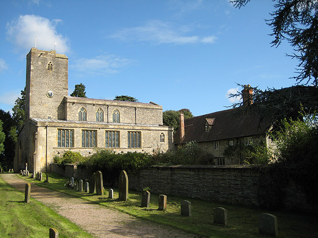
Chaceley is a close-knit community with a rich history. The village is home to a number of historic buildings, including St. John the Baptist Church, which dates back to the 12th century. The church is known for its beautiful stained glass windows and medieval architecture.

Although small in size, Chaceley has a strong sense of community spirit. It hosts various events throughout the year, such as summer fairs and village gatherings, which bring residents together. The village also has a local pub, The Red Lion, which serves as a social hub for both locals and visitors.

With its idyllic setting and welcoming community, Chaceley offers a peaceful countryside experience to those seeking a slower pace of life. It is a charming village that captures the essence of rural Worcestershire.

If you have any feedback on the listing, please let us know in the comments section below.

Chaceley Images

Images are sourced within 2km of 51.974129/-2.208803 or Grid Reference SO8530. Thanks to Geograph Open Source API. All images are credited.

Deerhurst, Priory Church of St. Mary the Virgin
Deerhurst: Flood Gate
Deerhurst, Priory Church of St. Mary the Virgin: Saxon tower
Deerhurst, Priory Church of St. Mary the Virgin: Doorway into the Saxon tower
Deerhurst, Priory Church of St. Mary the Virgin: West entrance with its Saxon arch
Deerhurst, Priory Church of St. Mary the Virgin: Double-headed Saxon window high on the nave west wall
Deerhurst, Priory Church of St. Mary the Virgin: Blocked doorway on the nave west wall The triangular aperture would have provided light to a Saxon western gallery, which no longer exists. A similar aperture exists in the north and south walls.
Deerhurst, Priory Church of St. Mary the Virgin: Blocked doorway on the nave west wall
The triangular aperture would have provided light to a Saxon western gallery, which no longer exists. A similar aperture exists in the north and south walls.
Deerhurst, Priory Church of St. Mary the Virgin: The pulpit
Deerhurst, Priory Church of St. Mary the Virgin: The pulpit (detail)
Deerhurst, Priory Church of St. Mary the Virgin: Ten Commandments on the east wall
Deerhurst, Priory Church of St. Mary the Virgin: Saxon masonry revealed
Deerhurst, Priory Church of St. Mary the Virgin: Nave capital
Deerhurst, Priory Church of St. Mary the Virgin: The west wall from the nave
Deerhurst, Priory Church of St. Mary the Virgin: Nave arches
Deerhurst, Priory Church of St. Mary the Virgin: Nave capital c.1200
Show me another place!

Chaceley is located at Grid Ref: SO8530 (Lat: 51.974129, Lng: -2.208803)

Administrative County: Gloucestershire

District: Tewkesbury

Police Authority: Gloucestershire

What 3 Words

///vertical.warbler.bloomers. Near Tewkesbury, Gloucestershire

Nearby Locations

Chaceley

Related Wikis

Chaceley Meadow SSSI

Chaceley Meadow (grid reference SO857306) is a 1.8-hectare (4.4-acre) biological Site of Special Scientific Interest in Gloucestershire, notified in 1954...

Chaceley

Chaceley or Chaseley is a village and civil parish 8 miles (13 km) north of Gloucester, in the Tewkesbury district, in the county of Gloucestershire, England...

Odda's Chapel

Odda's Chapel is a former chantry chapel at Deerhurst, Gloucestershire. It is an 11th-century late Anglo-Saxon building, completed a decade before the...

St Mary's Priory Church, Deerhurst

St Mary's Priory Church, Deerhurst, is the Church of England parish church of Deerhurst, Gloucestershire, England. Much of the church is Anglo-Saxon. It...

Nearby Amenities

Located within 500m of 51.974129,-2.208803
Chaceley
Is In: Gloucestershire, England, UK
Place: village
Lat/Long: 51.9748634/-2.2095759
Bus Stop
Werth Ln
Naptan AtcoCode: 1600GL9063
Naptan Bearing: SW
Naptan CommonName: Werth Ln
Naptan NaptanCode: glodgtwg
Naptan Street: Forthampton Rd
Naptan Verified: no
Source: naptan_import
Lat/Long: 51.9765695/-2.2068676
Bus Stop
Werth Ln
Naptan AtcoCode: 1600GL9064
Naptan Bearing: NE
Naptan CommonName: Werth Ln
Naptan NaptanCode: glodgtwa
Naptan Street: Forthampton Rd
Naptan Verified: no
Source: naptan_import
Lat/Long: 51.976673/-2.2069614
Bus Stop
St John the Baptist's Church
Naptan AtcoCode: 1600GL963
Naptan Bearing: W
Naptan CommonName: St John the Baptist's Church
Naptan NaptanCode: glodgmtg
Naptan Street: Church Ln
Naptan Verified: no
Source: naptan_import
Lat/Long: 51.9745019/-2.2117497
Bus Stop
St John the Baptist's Church
Naptan AtcoCode: 1600GL964
Naptan Bearing: E
Naptan CommonName: St John the Baptist's Church
Naptan NaptanCode: glodgmpt
Naptan Street: Church Ln
Naptan Verified: no
Source: naptan_import
Lat/Long: 51.9745554/-2.2119829
Chaceley Rye
Is In: Gloucestershire, England, UK
Place: hamlet
Source: NPE
Lat/Long: 51.970993/-2.2063058
Werth Farm
Landuse: farm
Note Retag: CS #48756035
Source: OS 1:25k
Lat/Long: 51.9778525/-2.2081072
Post Box
Post Box Type: lamp
Ref: GL19 314
Royal Cypher: EIIR
Royal Cypher Wikidata: Q33102113
Lat/Long: 51.9746711/-2.2111533
Historic: memorial
Memorial: war_memorial
Lat/Long: 51.9740994/-2.2127205
Advertising: board
Lat/Long: 51.9746792/-2.2111318
Telephone
Booth: K6
Covered: booth
Listed Status: Grade II
Operator: BT
Phone: +44 1452 780281
Lat/Long: 51.9746862/-2.211109
Power: pole
Lat/Long: 51.9726123/-2.2067218
Power: pole
Lat/Long: 51.9701156/-2.2120634
Power: pole
Lat/Long: 51.9706188/-2.2110119
Power: pole
Lat/Long: 51.9742358/-2.2136378
Power: pole
Lat/Long: 51.9714243/-2.2105747
Grain House
Power: pole
Transformer: distribution
Voltage Primary: 11000
Lat/Long: 51.9745439/-2.2134621
Power: pole
Lat/Long: 51.9736822/-2.213957
Power: pole
Lat/Long: 51.9730998/-2.2140536
Power: pole
Lat/Long: 51.9727842/-2.2133696
Power: pole
Lat/Long: 51.9720968/-2.2119682
Power: pole
Lat/Long: 51.9711368/-2.2099753
Power: pole
Lat/Long: 51.9716197/-2.2088756
Werth Farm
Power: pole
Transformer: distribution
Voltage Primary: 11000
Lat/Long: 51.9773907/-2.2084008
Vicarage Field
Power: pole
Transformer: distribution
Voltage Primary: 11000
Lat/Long: 51.9764208/-2.2086597
Location Transition: yes
Power: pole
Lat/Long: 51.9758764/-2.2088166
Chaceley
Power: pole
Transformer: distribution
Voltage Primary: 11000
Lat/Long: 51.9746092/-2.2098854
Power: pole
Lat/Long: 51.974073/-2.2093906
Power: pole
Lat/Long: 51.9726528/-2.2082949
Power: pole
Lat/Long: 51.9733567/-2.2088233
Power: pole
Lat/Long: 51.9706039/-2.205673
Chaceley Rye
Power: pole
Transformer: distribution
Voltage Primary: 11000
Lat/Long: 51.9710083/-2.2062732
Power: pole
Lat/Long: 51.9716172/-2.2071194
Power: pole
Lat/Long: 51.972103/-2.2078168
Power: pole
Lat/Long: 51.9730824/-2.2056676
Power: pole
Lat/Long: 51.9735781/-2.2045679
Power: pole
Lat/Long: 51.9739408/-2.2038665
Power: pole
Lat/Long: 51.9744596/-2.2028406
Power: pole
Lat/Long: 51.9749826/-2.2018066
The data included in this document is from www.openstreetmap.org. The data is made available under ODbL.

Have you been to Chaceley?

Leave your review of Chaceley below (or comments, questions and feedback).