Ellwynd Wood

Wood, Forest in Roxburghshire

Scotland

Ellwynd Wood

Tweedbank station An aerial view over Tweedbank station looking towards Melrose.

Forms part of Railway Routes Blogpost <span class="nowrap"><a title="https://tinyurl.com/e94tw557" rel="nofollow ugc noopener" href="https://tinyurl.com/e94tw557">Link</a><img style="margin-left:2px;" alt="External link" title="External link - shift click to open in new window" src="https://s1.geograph.org.uk/img/external.png" width="10" height="10"/></span>
Tweedbank station Credit: Trevor Edward Streeter

Ellwynd Wood, located in Roxburghshire, Scotland, is a captivating woodland that boasts a diverse array of natural beauty and serves as a haven for outdoor enthusiasts and nature lovers alike. Spanning approximately 200 acres, this enchanting forest is nestled amidst rolling hills and picturesque landscapes.

The wood is predominantly composed of native broadleaf trees, including oak, birch, and beech, which create a lush and vibrant canopy overhead. The dense undergrowth consists of ferns, mosses, and wildflowers, adding to the woodland's overall charm. The forest floor is adorned with a rich carpet of fallen leaves, creating a serene and peaceful atmosphere.

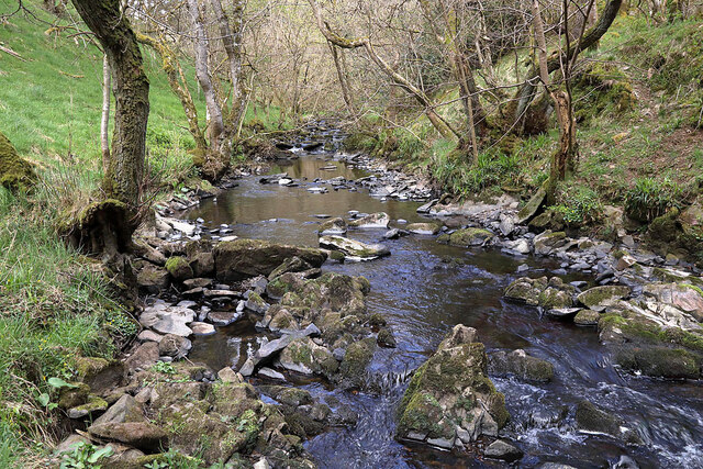
Ellwynd Wood offers a network of well-maintained trails and pathways, making it an ideal destination for hiking and walking. These paths lead visitors through various sections of the forest, allowing them to explore its hidden corners and discover its hidden treasures. The wood also features a small stream that meanders through its heart, providing a calming ambiance and attracting a variety of wildlife.

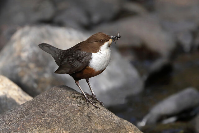
Birdwatchers will find Ellwynd Wood particularly captivating, as it serves as a habitat for numerous species of birds, including woodpeckers, owls, and various songbirds. The forest's tranquil environment and abundant food sources make it an ideal nesting ground for these feathered creatures.

The natural beauty and tranquility of Ellwynd Wood make it a popular location for nature photography and painting. Many artists and photographers visit the wood, capturing its breathtaking landscapes and unique flora and fauna.

In summary, Ellwynd Wood is a captivating forest in Roxburghshire, Scotland, offering an abundance of natural beauty, diverse wildlife, and peaceful trails for outdoor enthusiasts to explore and appreciate.

If you have any feedback on the listing, please let us know in the comments section below.

Ellwynd Wood Images

Images are sourced within 2km of 55.613813/-2.7516698 or Grid Reference NT5235. Thanks to Geograph Open Source API. All images are credited.

Tweedbank station An aerial view over Tweedbank station looking towards Melrose.

Forms part of Railway Routes Blogpost <span class="nowrap"><a title="https://tinyurl.com/e94tw557" rel="nofollow ugc noopener" href="https://tinyurl.com/e94tw557">Link</a><img style="margin-left:2px;" alt="External link" title="External link - shift click to open in new window" src="https://s1.geograph.org.uk/img/external.png" width="10" height="10"/></span>
Tweedbank station
An aerial view over Tweedbank station looking towards Melrose. Forms part of Railway Routes Blogpost LinkExternal link
Tweedbank station Aerial view of Tweedbank station which forms part of "Railway Routes" BlogPost <span class="nowrap"><a title="https://tinyurl.com/e94tw557" rel="nofollow ugc noopener" href="https://tinyurl.com/e94tw557">Link</a><img style="margin-left:2px;" alt="External link" title="External link - shift click to open in new window" src="https://s1.geograph.org.uk/img/external.png" width="10" height="10"/></span>
Tweedbank station
Aerial view of Tweedbank station which forms part of "Railway Routes" BlogPost LinkExternal link
Broomilees Road. Infilled Railway cutting At this point was an over bridge on the Waverley Line, now infilled.


<span class="nowrap"><a title="https://tinyurl.com/e94tw557" rel="nofollow ugc noopener" href="https://tinyurl.com/e94tw557">Link</a><img style="margin-left:2px;" alt="External link" title="External link - shift click to open in new window" src="https://s1.geograph.org.uk/img/external.png" width="10" height="10"/></span>
Broomilees Road. Infilled Railway cutting
At this point was an over bridge on the Waverley Line, now infilled. LinkExternal link
170426 terminating at Tweedbank Station
Southern Upland Way, Winston Road Galashiels The Way is signposted left onto a path to Galafoot where the Gala Water meets the Tweed.
Southern Upland Way, Winston Road Galashiels
The Way is signposted left onto a path to Galafoot where the Gala Water meets the Tweed.
Pipe bridge over the Gala Water Presumably a sewage pipe at Galafoot.
Pipe bridge over the Gala Water
Presumably a sewage pipe at Galafoot.
Gala Water and the Tweed The confluence at Galafoot where the Gala Water mingles with the Tweed after a 30km journey from its source near Falahill. Wild garlic is in the foreground.
Gala Water and the Tweed
The confluence at Galafoot where the Gala Water mingles with the Tweed after a 30km journey from its source near Falahill. Wild garlic is in the foreground.
Two level bridge, Galafoot/Langlee A strikingly different bridge which crosses the railway and river. It may date back to before the closure of the Waverley Line, it predates the reopening.  It also predates the time folk started giving consideration to wheelchair users and young families.
Two level bridge, Galafoot/Langlee
A strikingly different bridge which crosses the railway and river. It may date back to before the closure of the Waverley Line, it predates the reopening. It also predates the time folk started giving consideration to wheelchair users and young families.
Gas holder, Galafoot The site of the gasworks,  still used as part of the distribution network.
Gas holder, Galafoot
The site of the gasworks, still used as part of the distribution network.
Winston Road, Galafoot
Redbridge Viaduct
Redbridge Viaduct
Path beside the Tweed A few sets of steps here.
Path beside the Tweed
A few sets of steps here.
River Tweed Upstream view towards the Galafoot Bridge.
River Tweed
Upstream view towards the Galafoot Bridge.
Borders Abbey Way, Tweedbank
A dipper at the Allan Water Dippers (Cinclus cinclus) can be found on fast flowing upland streams where they feed on aquatic invertebrates.
A dipper at the Allan Water
Dippers (Cinclus cinclus) can be found on fast flowing upland streams where they feed on aquatic invertebrates.
The Allan Water This is a view upstream to the west of Avenel Moss.
The Allan Water
This is a view upstream to the west of Avenel Moss.
Ambulance station, Borders General Hospital The ambulance station near the entrance to BGH.
Ambulance station, Borders General Hospital
The ambulance station near the entrance to BGH.
Busy Bees nursery near Melrose Cricket Club A children's nursery near the entrance to the Borders General Hospital and the access road for the cricket club.
Busy Bees nursery near Melrose Cricket Club
A children's nursery near the entrance to the Borders General Hospital and the access road for the cricket club.
Show me another place!

Ellwynd Wood is located at Grid Ref: NT5235 (Lat: 55.613813, Lng: -2.7516698)

Unitary Authority: The Scottish Borders

Police Authority: The Lothians and Scottish Borders

What 3 Words

///beaters.covertly.trespass. Near Tweedbank, Scottish Borders

Related Wikis

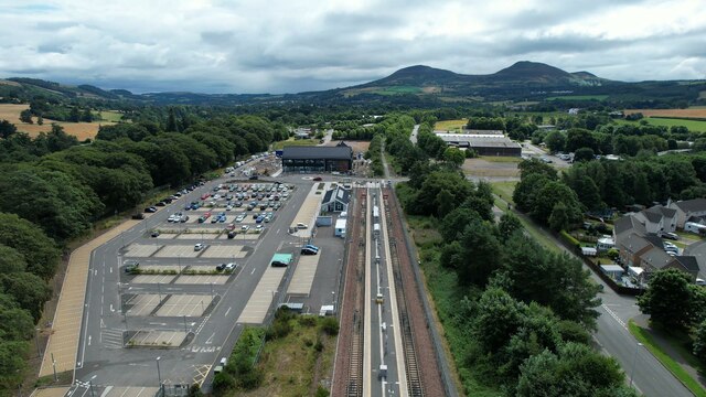
Tweedbank railway station

Tweedbank is a railway station on the Borders Railway, which runs between Edinburgh Waverley and Tweedbank. The station, situated 35 miles 34 chains (57...
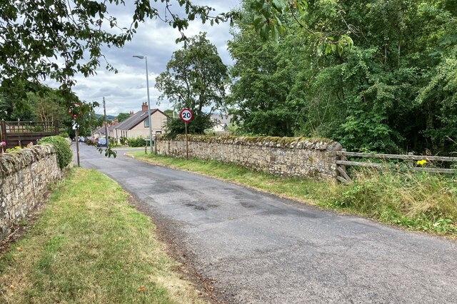
Tweedbank

Tweedbank is a large village south-east of Galashiels in the Scottish Borders, Scotland. It is part of the county of Roxburghshire. It is an outer suburb...

Darnick

Darnick is a village near Melrose in the Scottish Borders area of Scotland, in the former Roxburghshire. The name was first recorded in 1124, and has changed...

Gattonside

Gattonside is a small village in the Scottish Borders. It is located 1 kilometre (0.62 mi) north of Melrose, on the north side of the River Tweed. In 1143...

Gala Water

The Gala Water (Lowland Scots: Gala Watter; Scottish Gaelic An Geal Ath) is a river in the Scottish Borders area of Scotland and a tributary of the River...

Netherdale

Netherdale is a sports complex in Galashiels, Scottish Borders, consisting of two adjacent stadiums used for rugby union and football. The rugby ground...

Borders General Hospital

Borders General Hospital (BGH) is a district general hospital on the outskirts of Melrose, Scotland. It is managed by NHS Borders. == History == The hospital...

Borders College

Borders College (Scottish Gaelic: Colaiste nan Crìochan) is a further education institution in the Scottish Borders, Scotland. Its main campus is located...

Nearby Amenities

Located within 500m of 55.613813,-2.7516698
Bus Stop
Pavilion Road End
Bench: no
Bus: yes
Departures Board: no
Lit: no
Local Ref: opp
Naptan AtcoCode: 6900626
Naptan Bearing: W
Naptan CommonName: Pavilion Rd End
Naptan Indicator: opp
Naptan Landmark: Road End
Naptan NaptanCode: 72723969
Naptan Street: B6374
Naptan Verified: yes
Public Transport: platform
Ref: 6900626
Shelter: no
Source: local knowledge;survey;NaPTAN
Lat/Long: 55.6097722/-2.7545249
Bus Stop
Pavilion Road End
Bench: no
Bus: yes
Departures Board: no
Lit: no
Local Ref: nr
Naptan AtcoCode: 6900627
Naptan Bearing: E
Naptan CommonName: Pavilion Rd End
Naptan Indicator: nr
Naptan Landmark: Road End
Naptan NaptanCode: 72723972
Naptan Street: B6374
Naptan Verified: yes
Note: No bus stop sign
Public Transport: platform
Ref: 6900627
Shelter: no
Source: local knowledge;survey
Lat/Long: 55.6098932/-2.7545268
Power: tower
Lat/Long: 55.6140772/-2.7498783
Power: tower
Lat/Long: 55.6139244/-2.7438055
Power: tower
Lat/Long: 55.6157732/-2.7571713
Allan Lodge
Place: isolated_dwelling
Lat/Long: 55.6097112/-2.7525979
Pavilion Farm
Place: isolated_dwelling
Lat/Long: 55.6100536/-2.7517821
Power: tower
Lat/Long: 55.6139994/-2.7462333
Power: tower
Lat/Long: 55.6140202/-2.7480253
Power: tower
Lat/Long: 55.6147935/-2.7528865
Power: tower
Lat/Long: 55.6152434/-2.7547815
Power: pole
Lat/Long: 55.6121349/-2.7442886
Power: pole
Lat/Long: 55.6122919/-2.7454883
Power: pole
Lat/Long: 55.6124516/-2.746687
Power: pole
Lat/Long: 55.6127624/-2.7493317
Power: pole
Lat/Long: 55.6129104/-2.7508308
Generator Method: photovoltaic
Generator Output Electricity: yes
Generator Source: solar
Generator Type: solar_photovoltaic_panel
Power: generator
Lat/Long: 55.6097356/-2.7503331
Generator Method: photovoltaic
Generator Output Electricity: yes
Generator Source: solar
Generator Type: solar_photovoltaic_panel
Power: generator
Lat/Long: 55.6140705/-2.7588537
Generator Method: photovoltaic
Generator Output Electricity: yes
Generator Source: solar
Generator Type: solar_photovoltaic_panel
Power: generator
Lat/Long: 55.6140705/-2.7589484
Generator Method: photovoltaic
Generator Output Electricity: yes
Generator Source: solar
Generator Type: solar_photovoltaic_panel
Power: generator
Lat/Long: 55.6140737/-2.7587714
Generator Method: photovoltaic
Generator Output Electricity: yes
Generator Source: solar
Generator Type: solar_photovoltaic_panel
Power: generator
Lat/Long: 55.6141227/-2.7590986
Generator Method: photovoltaic
Generator Output Electricity: yes
Generator Source: solar
Generator Type: solar_photovoltaic_panel
Power: generator
Lat/Long: 55.6141189/-2.7593158
Generator Method: photovoltaic
Generator Output Electricity: yes
Generator Source: solar
Generator Type: solar_photovoltaic_panel
Power: generator
Lat/Long: 55.6141189/-2.7594486
Generator Method: photovoltaic
Generator Output Electricity: yes
Generator Source: solar
Generator Type: solar_photovoltaic_panel
Power: generator
Lat/Long: 55.6141151/-2.7595451
Power: pole
Lat/Long: 55.6130484/-2.7521669
Generator Method: photovoltaic
Generator Output Electricity: yes
Generator Source: solar
Generator Type: solar_photovoltaic_panel
Power: generator
Lat/Long: 55.61385/-2.7595773
Generator Method: photovoltaic
Generator Output Electricity: yes
Generator Source: solar
Generator Type: solar_photovoltaic_panel
Power: generator
Lat/Long: 55.6138538/-2.7594084
Generator Method: photovoltaic
Generator Output Electricity: yes
Generator Source: solar
Generator Type: solar_photovoltaic_panel
Power: generator
Lat/Long: 55.6132199/-2.7595519
Generator Method: photovoltaic
Generator Output Electricity: yes
Generator Source: solar
Generator Type: solar_photovoltaic_panel
Power: generator
Lat/Long: 55.6132252/-2.7594875
Generator Method: photovoltaic
Generator Output Electricity: yes
Generator Source: solar
Generator Type: solar_photovoltaic_panel
Power: generator
Lat/Long: 55.6132479/-2.7593668
Generator Method: photovoltaic
Generator Output Electricity: yes
Generator Source: solar
Generator Type: solar_photovoltaic_panel
Power: generator
Lat/Long: 55.6132555/-2.7592836
Generator Method: photovoltaic
Generator Output Electricity: yes
Generator Source: solar
Generator Type: solar_photovoltaic_panel
Power: generator
Lat/Long: 55.613332/-2.7590007
Generator Method: photovoltaic
Generator Output Electricity: yes
Generator Source: solar
Generator Type: solar_photovoltaic_panel
Power: generator
Lat/Long: 55.6133842/-2.7590221
Generator Method: photovoltaic
Generator Output Electricity: yes
Generator Source: solar
Generator Type: solar_photovoltaic_panel
Power: generator
Lat/Long: 55.6134115/-2.7590355
Generator Method: photovoltaic
Generator Output Electricity: yes
Generator Source: solar
Generator Type: solar_photovoltaic_panel
Power: generator
Lat/Long: 55.6134554/-2.7591388
Generator Method: photovoltaic
Generator Output Electricity: yes
Generator Source: solar
Generator Type: solar_photovoltaic_panel
Power: generator
Lat/Long: 55.6135092/-2.7591039
Generator Method: photovoltaic
Generator Output Electricity: yes
Generator Source: solar
Generator Type: solar_photovoltaic_panel
Power: generator
Lat/Long: 55.6135668/-2.759002
Generator Method: photovoltaic
Generator Output Electricity: yes
Generator Source: solar
Generator Type: solar_photovoltaic_panel
Power: generator
Lat/Long: 55.6135675/-2.7589175
Generator Method: photovoltaic
Generator Output Electricity: yes
Generator Source: solar
Generator Type: solar_photovoltaic_panel
Power: generator
Lat/Long: 55.6135787/-2.7588438
Generator Method: photovoltaic
Generator Output Electricity: yes
Generator Source: solar
Generator Type: solar_photovoltaic_panel
Power: generator
Lat/Long: 55.6135897/-2.7587512
Generator Method: photovoltaic
Generator Output Electricity: yes
Generator Source: solar
Generator Type: solar_photovoltaic_panel
Power: generator
Lat/Long: 55.6136024/-2.7586718
Generator Method: photovoltaic
Generator Output Electricity: yes
Generator Source: solar
Generator Type: solar_photovoltaic_panel
Power: generator
Lat/Long: 55.6138324/-2.759052
Generator Method: photovoltaic
Generator Output Electricity: yes
Generator Source: solar
Generator Type: solar_photovoltaic_panel
Power: generator
Lat/Long: 55.6138309/-2.7591465
Generator Method: photovoltaic
Generator Output Electricity: yes
Generator Source: solar
Generator Type: solar_photovoltaic_panel
Power: generator
Lat/Long: 55.6138352/-2.7588627
Generator Method: photovoltaic
Generator Output Electricity: yes
Generator Source: solar
Generator Type: solar_photovoltaic_panel
Power: generator
Lat/Long: 55.6138337/-2.7589572
Generator Method: photovoltaic
Generator Output Electricity: yes
Generator Source: solar
Generator Type: solar_photovoltaic_panel
Power: generator
Lat/Long: 55.6138447/-2.7587252
Power: pole
Lat/Long: 55.6126172/-2.7478797
Power: pole
Lat/Long: 55.6118345/-2.748236
Power: pole
Lat/Long: 55.6111316/-2.7485745
Power: pole
Lat/Long: 55.6104804/-2.7488418
Power: pole
Lat/Long: 55.6098623/-2.7491255
Power: pole
Lat/Long: 55.6132417/-2.7540821
Parking
Lat/Long: 55.613163/-2.7570364
Parking
Lat/Long: 55.6134749/-2.7571494
The data included in this document is from www.openstreetmap.org. The data is made available under ODbL.

Have you been to Ellwynd Wood?

Leave your review of Ellwynd Wood below (or comments, questions and feedback).