Catherine's Plantation

Wood, Forest in Roxburghshire

Scotland

Catherine's Plantation

Field near Synton Mill
Field near Synton Mill Credit: Richard Webb

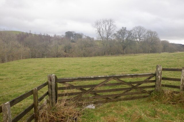
Catherine's Plantation is a charming woodland area located in Roxburghshire, Scotland. This exquisite plantation covers a vast area of lush greenery, comprising a variety of trees, bushes, and plants, creating a serene and picturesque environment.

The plantation is named after Catherine, a prominent figure in the local community, who dedicated her life to cultivating and maintaining this stunning woodland. It is believed that Catherine began planting the seeds of this forest more than a century ago, and her legacy lives on through the magnificent growth and beauty of the plantation.

Walking through Catherine's Plantation, visitors are greeted by a diverse range of tree species, including oak, ash, birch, and beech, among others. The forest floor is covered in a vibrant carpet of ferns, wildflowers, and moss, creating a captivating sight throughout the seasons.

The plantation is not only a haven for nature enthusiasts but also provides a home to a variety of wildlife. Squirrels, deer, and numerous bird species can be spotted among the trees, adding to the enchantment of the woodland.

Visitors are encouraged to explore the network of well-maintained trails that wind through the plantation, allowing them to fully immerse themselves in the tranquility and beauty of this natural wonder. The plantation also offers picnic areas and designated spots for birdwatching, making it an ideal destination for a family outing or a peaceful retreat.

Catherine's Plantation is not only a testament to the dedication of its namesake but also stands as a testament to the importance of preserving and appreciating the natural environment.

If you have any feedback on the listing, please let us know in the comments section below.

Catherine's Plantation Images

Images are sourced within 2km of 55.49096/-2.8177937 or Grid Reference NT4822. Thanks to Geograph Open Source API. All images are credited.

Field near Synton Mill
Mill Cottage at Dimpleknowe This is a 2 storey former mill that has recently been converted into self catering holiday accommodation
Mill Cottage at Dimpleknowe
This is a 2 storey former mill that has recently been converted into self catering holiday accommodation
Dimpleknowe Dimpleknowe is a small country estate to the east of Ashkirk that offers self catering holiday accommodation, and a nine hole golf course. For more information see:- <span class="nowrap"><a title="www.dimpleknowe.co.uk" rel="nofollow ugc noopener" href="http://www.dimpleknowe.co.uk">Link</a><img style="margin-left:2px;" alt="External link" title="External link - shift click to open in new window" src="https://s1.geograph.org.uk/img/external.png" width="10" height="10"/></span>
Dimpleknowe
Dimpleknowe is a small country estate to the east of Ashkirk that offers self catering holiday accommodation, and a nine hole golf course. For more information see:- LinkExternal link
A hungry pond This pond at Dimpleknowe likes to be fed golf balls.  Lillesleaf Golf Course.
A hungry pond
This pond at Dimpleknowe likes to be fed golf balls. Lillesleaf Golf Course.
Dimpleknowe Mill, Dimpleknowe
Approaching Dimpleknowe Down the hill to Dimpleknowe Mill.
Approaching Dimpleknowe
Down the hill to Dimpleknowe Mill.
Road near Dimpleknowe The gate to the right is obviously a favourite rubbing-place for sheep! The cottage in the background is just to the north of Dimpleknowe Mill.
Road near Dimpleknowe
The gate to the right is obviously a favourite rubbing-place for sheep! The cottage in the background is just to the north of Dimpleknowe Mill.
Hooray! Some 'May'! Not quite out yet, but exciting to see so many buds ready to open - it's been a long wait this year: hawthorn is often in flower in mid-April.
Hooray! Some 'May'!
Not quite out yet, but exciting to see so many buds ready to open - it's been a long wait this year: hawthorn is often in flower in mid-April.
Dimpleknowe Mill
Dimpleknowe Mill
Road to Syntonmill Leading northwesterly from Dimpleknowe.
Road to Syntonmill
Leading northwesterly from Dimpleknowe.
Road by Dimpleknowe Mill Looking southeasterly towards Satchells.
Road by Dimpleknowe Mill
Looking southeasterly towards Satchells.
Verdant verge at Dimpleknowe There's a wide range of wild plants and flowers in this area. Here we have mainly butterbur, interspersed with cow parsley, stinging nettles and dock.
Verdant verge at Dimpleknowe
There's a wide range of wild plants and flowers in this area. Here we have mainly butterbur, interspersed with cow parsley, stinging nettles and dock.
Downhill to Syntonmill The minor road from Dimpleknowe goes via Syntonmill (visible in the background of the picture) to join the A7 just south of Ashkirk.
Downhill to Syntonmill
The minor road from Dimpleknowe goes via Syntonmill (visible in the background of the picture) to join the A7 just south of Ashkirk.
Syntonmill lade The lade from Syntonmill runs close beside the road before turning northeastward to join the Ale Water.  Boosmill Hill can be seen in the left background.
Syntonmill lade
The lade from Syntonmill runs close beside the road before turning northeastward to join the Ale Water. Boosmill Hill can be seen in the left background.
A small burn flowing from Syntonmill into the Ale Water
Minor road from Syntonmill to Dimpleknowe I just love these place names!
Minor road from Syntonmill to Dimpleknowe
I just love these place names!
Grazing pasture beside the Ale Water Another lovely name to roll off the tongue!
Grazing pasture beside the Ale Water
Another lovely name to roll off the tongue!
Lade, Synton Mill Returning to the Ale Water, downstream of Synton Mill.
Lade, Synton Mill
Returning to the Ale Water, downstream of Synton Mill.
Show me another place!

Catherine's Plantation is located at Grid Ref: NT4822 (Lat: 55.49096, Lng: -2.8177937)

Unitary Authority: The Scottish Borders

Police Authority: The Lothians and Scottish Borders

What 3 Words

///fancy.conspired.speakers. Near Selkirk, Scottish Borders

Related Wikis

Bowismiln

Bowismiln is a village in the Scottish Borders area of Scotland. == See also == List of places in the Scottish Borders List of places in Scotland ��2...

Woll

Woll is a village on the Ale Water, off the A7, in the Ettrick Forest, north of Hawick, and south of Selkirk in the Scottish Borders area of Scotland....

Ashkirk

Ashkirk is a small village on the Ale Water, in the Scottish Borders area of Scotland. It is located just off the A7 road, approximately 6 miles (10 kilometres...

Salenside

Salenside is a village off the A7, on the Ale Water, near Ashkirk, in the Scottish Borders area of Scotland, in the former Selkirkshire. There was a Salenside...

Lilliesleaf

Lilliesleaf is a small village and civil parish 7 miles (11 km) south east of Selkirk in the Roxburghshire area of Scottish Borders of Scotland. Other...

Lothian and Borders

Lothian and Borders is an area in Scotland consisting of the East Lothian, City of Edinburgh, Midlothian, West Lothian council areas (collectively known...
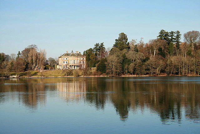
The Haining

The Haining is a country house and estate in Selkirk in the Scottish Borders. The present house dates from the 1790s, and was a property of the Pringle...

Selkirk Town House

Selkirk Town House is a municipal building in the Market Place, Selkirk, Scottish Borders, Scotland. The structure, which is used as a local history museum...

Nearby Amenities

Located within 500m of 55.49096,-2.8177937
Synton
Place: hamlet
Lat/Long: 55.492463/-2.8126112
Sinton House (site of)
Historic: archaeological_site
Lat/Long: 55.4923103/-2.8129862
Noexit: yes
Lat/Long: 55.4925091/-2.8157102
Noexit: yes
Lat/Long: 55.492501/-2.811808
Generator Method: photovoltaic
Generator Output Electricity: yes
Generator Source: solar
Generator Type: solar_photovoltaic_panel
Power: generator
Lat/Long: 55.4921758/-2.8133033
Power: pole
Lat/Long: 55.4926264/-2.8243545
Power: pole
Lat/Long: 55.4931501/-2.8231005
Power: pole
Lat/Long: 55.4935848/-2.8220422
Power: pole
Lat/Long: 55.4938897/-2.8212903
Power: pole
Lat/Long: 55.4943244/-2.8205358
Power: pole
Lat/Long: 55.4947387/-2.8198277
Power: pole
Lat/Long: 55.4952565/-2.8188852
Power: pole
Lat/Long: 55.4933864/-2.8111475
Power: pole
Lat/Long: 55.4928/-2.8105732
Power: pole
Lat/Long: 55.4923128/-2.8231442
Power: pole
Lat/Long: 55.4920619/-2.8221812
Power: pole
Lat/Long: 55.4919292/-2.8216714
Power: pole
Lat/Long: 55.4920108/-2.8207032
Power: pole
Lat/Long: 55.4917687/-2.8194723
Power: pole
Lat/Long: 55.4917206/-2.8184114
Power: pole
Lat/Long: 55.4916462/-2.8168742
Power: pole
Lat/Long: 55.491916/-2.8161661
Power: pole
Lat/Long: 55.490927/-2.8163206
Power: pole
Lat/Long: 55.4906775/-2.8161352
Power: pole
Lat/Long: 55.4900075/-2.8156368
Power: pole
Lat/Long: 55.4893412/-2.8151412
Power: pole
Lat/Long: 55.4886424/-2.8146185
Power: pole
Lat/Long: 55.4878969/-2.8140726
Power: pole
Lat/Long: 55.4872302/-2.8135808
Power: pole
Lat/Long: 55.4883812/-2.8184629
Power: pole
Lat/Long: 55.4888714/-2.8180329
Power: pole
Lat/Long: 55.4892099/-2.8177239
Power: pole
Lat/Long: 55.4895454/-2.8174407
Power: pole
Lat/Long: 55.4898416/-2.8171214
Power: pole
Lat/Long: 55.4902165/-2.8167351
Power: pole
Lat/Long: 55.4906498/-2.8162742
Power: pole
Lat/Long: 55.4910991/-2.8158107
Power: pole
Lat/Long: 55.4915907/-2.8152133
The data included in this document is from www.openstreetmap.org. The data is made available under ODbL.

Have you been to Catherine's Plantation?

Leave your review of Catherine's Plantation below (or comments, questions and feedback).