Synton

Settlement in Roxburghshire

Scotland

Synton

Road junction, Dimpleknowe
Road junction, Dimpleknowe Credit: Richard Webb

Synton is a small village located in the region of Roxburghshire, in the Scottish Borders, Scotland. Situated approximately 4 miles northwest of the town of Kelso, Synton is surrounded by picturesque countryside and offers a tranquil and rural atmosphere.

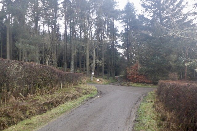
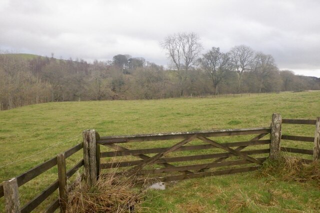
The village is known for its beautiful landscape, featuring rolling hills, lush green fields, and charming woodlands. It is a popular destination for outdoor enthusiasts, with numerous walking and cycling trails available in the area. The nearby River Teviot also provides opportunities for fishing and boating.

Synton has a small population, with a close-knit community that takes pride in their village. There are a mix of traditional stone cottages and more modern houses, adding to the character of the area. Although there are no major amenities in Synton itself, residents have easy access to nearby towns for shopping, healthcare, and other services.

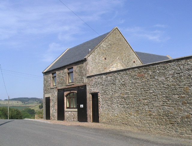
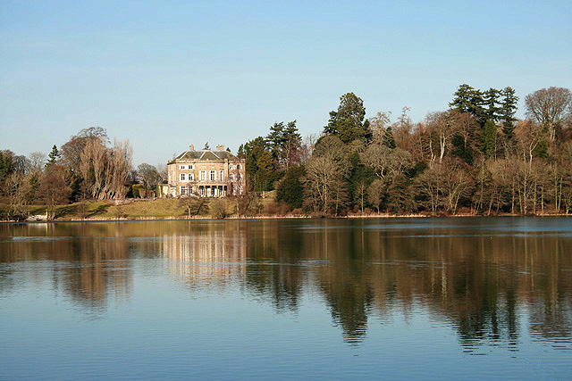
One notable landmark in Synton is the Synton House, a historic mansion dating back to the 17th century. The house is a fine example of Jacobean architecture and is surrounded by well-maintained gardens.

Overall, Synton offers a peaceful and idyllic setting for those seeking a rural lifestyle. With its natural beauty and strong sense of community, it is a charming place to call home or visit for a relaxing getaway.

If you have any feedback on the listing, please let us know in the comments section below.

Synton Images

Images are sourced within 2km of 55.4927/-2.8139 or Grid Reference NT4822. Thanks to Geograph Open Source API. All images are credited.

Road junction, Dimpleknowe
Field near Synton Mill
Mill Cottage at Dimpleknowe This is a 2 storey former mill that has recently been converted into self catering holiday accommodation
Mill Cottage at Dimpleknowe
This is a 2 storey former mill that has recently been converted into self catering holiday accommodation
The 7th green at Lilliesleaf Golf Course near Dimpleknowe
Plantation at Dimpleknowe The southeast corner of Edward's Plantation and new tree planting by the road to Satchels Farm. Lilliesleaf 9 hole golf course is in the background.
Plantation at Dimpleknowe
The southeast corner of Edward's Plantation and new tree planting by the road to Satchels Farm. Lilliesleaf 9 hole golf course is in the background.
Dimpleknowe Dimpleknowe is a small country estate to the east of Ashkirk that offers self catering holiday accommodation, and a nine hole golf course. For more information see:- <span class="nowrap"><a title="www.dimpleknowe.co.uk" rel="nofollow ugc noopener" href="http://www.dimpleknowe.co.uk">Link</a><img style="margin-left:2px;" alt="External link" title="External link - shift click to open in new window" src="https://s1.geograph.org.uk/img/external.png" width="10" height="10"/></span>
Dimpleknowe
Dimpleknowe is a small country estate to the east of Ashkirk that offers self catering holiday accommodation, and a nine hole golf course. For more information see:- LinkExternal link
A hungry pond This pond at Dimpleknowe likes to be fed golf balls.  Lillesleaf Golf Course.
A hungry pond
This pond at Dimpleknowe likes to be fed golf balls. Lillesleaf Golf Course.
Dimpleknowe Mill, Dimpleknowe
Lilliesleaf Golf Course There are eleven holes at this parkland course at Dimpleknowe in the Scottish Borders. These golfers are playing the 4th hole called Satchells. For more information about the golf course, see <span class="nowrap"><a title="http://www.dimpleknowe.co.uk/golf.html" rel="nofollow ugc noopener" href="http://www.dimpleknowe.co.uk/golf.html">Link</a><img style="margin-left:2px;" alt="External link" title="External link - shift click to open in new window" src="https://s1.geograph.org.uk/img/external.png" width="10" height="10"/></span>
Lilliesleaf Golf Course
There are eleven holes at this parkland course at Dimpleknowe in the Scottish Borders. These golfers are playing the 4th hole called Satchells. For more information about the golf course, see LinkExternal link
Farmland at Satchells The foreground field was stocked with sheep (out of shot) on my visit while Lilliesleaf Golf Course is on the left on the northwest side of the Satchells Burn.
Farmland at Satchells
The foreground field was stocked with sheep (out of shot) on my visit while Lilliesleaf Golf Course is on the left on the northwest side of the Satchells Burn.
Lilliesleaf Golf Course There are eleven holes at this parkland course at Dimpleknowe in the Scottish Borders. These players are on the 7th green of the par 3 hole called Edwards. For more information about the golf course, see <span class="nowrap"><a title="http://www.dimpleknowe.co.uk/golf.html" rel="nofollow ugc noopener" href="http://www.dimpleknowe.co.uk/golf.html">Link</a><img style="margin-left:2px;" alt="External link" title="External link - shift click to open in new window" src="https://s1.geograph.org.uk/img/external.png" width="10" height="10"/></span>
Lilliesleaf Golf Course
There are eleven holes at this parkland course at Dimpleknowe in the Scottish Borders. These players are on the 7th green of the par 3 hole called Edwards. For more information about the golf course, see LinkExternal link
Lilliesleaf Golf Course There are eleven holes at this parkland course at Dimpleknowe in the Scottish Borders. These players are approaching the green on the 4th hole called Satchells. For more information about the golf course, see <span class="nowrap"><a title="http://www.dimpleknowe.co.uk/golf.html" rel="nofollow ugc noopener" href="http://www.dimpleknowe.co.uk/golf.html">Link</a><img style="margin-left:2px;" alt="External link" title="External link - shift click to open in new window" src="https://s1.geograph.org.uk/img/external.png" width="10" height="10"/></span>
Lilliesleaf Golf Course
There are eleven holes at this parkland course at Dimpleknowe in the Scottish Borders. These players are approaching the green on the 4th hole called Satchells. For more information about the golf course, see LinkExternal link
Approaching Dimpleknowe Down the hill to Dimpleknowe Mill.
Approaching Dimpleknowe
Down the hill to Dimpleknowe Mill.
Road near Dimpleknowe The gate to the right is obviously a favourite rubbing-place for sheep! The cottage in the background is just to the north of Dimpleknowe Mill.
Road near Dimpleknowe
The gate to the right is obviously a favourite rubbing-place for sheep! The cottage in the background is just to the north of Dimpleknowe Mill.
Hooray! Some 'May'! Not quite out yet, but exciting to see so many buds ready to open - it's been a long wait this year: hawthorn is often in flower in mid-April.
Hooray! Some 'May'!
Not quite out yet, but exciting to see so many buds ready to open - it's been a long wait this year: hawthorn is often in flower in mid-April.
Dimpleknowe Mill
Dimpleknowe Mill
Road to Syntonmill Leading northwesterly from Dimpleknowe.
Road to Syntonmill
Leading northwesterly from Dimpleknowe.
Road by Dimpleknowe Mill Looking southeasterly towards Satchells.
Road by Dimpleknowe Mill
Looking southeasterly towards Satchells.
Show me another place!

Synton is located at Grid Ref: NT4822 (Lat: 55.4927, Lng: -2.8139)

Unitary Authority: The Scottish Borders

Police Authority: The Lothians and Scottish Borders

What 3 Words

///scavenger.shredder.surveyed. Near Selkirk, Scottish Borders

Related Wikis

Bowismiln

Bowismiln is a village in the Scottish Borders area of Scotland. == See also == List of places in the Scottish Borders List of places in Scotland ��2...

Woll

Woll is a village on the Ale Water, off the A7, in the Ettrick Forest, north of Hawick, and south of Selkirk in the Scottish Borders area of Scotland....

Ashkirk

Ashkirk is a small village on the Ale Water, in the Scottish Borders area of Scotland. It is located just off the A7 road, approximately 6 miles (10 kilometres...

Salenside

Salenside is a village off the A7, on the Ale Water, near Ashkirk, in the Scottish Borders area of Scotland, in the former Selkirkshire. There was a Salenside...

Lilliesleaf

Lilliesleaf is a small village and civil parish 7 miles (11 km) south east of Selkirk in the Roxburghshire area of Scottish Borders of Scotland. Other...

Lothian and Borders

Lothian and Borders is an area in Scotland consisting of the East Lothian, City of Edinburgh, Midlothian, West Lothian council areas (collectively known...

The Haining

The Haining is a country house and estate in Selkirk in the Scottish Borders. The present house dates from the 1790s, and was a property of the Pringle...

Selkirk Town House

Selkirk Town House is a municipal building in the Market Place, Selkirk, Scottish Borders, Scotland. The structure, which is used as a local history museum...

Nearby Amenities

Located within 500m of 55.4927,-2.8139
Garden Cottage
Place: isolated_dwelling
Lat/Long: 55.4925731/-2.8101257
Synton
Place: hamlet
Lat/Long: 55.492463/-2.8126112
Whinfield
Place: isolated_dwelling
Lat/Long: 55.4969094/-2.8138415
Noexit: yes
Lat/Long: 55.4925607/-2.8102346
Sinton House (site of)
Historic: archaeological_site
Lat/Long: 55.4923103/-2.8129862
Noexit: yes
Lat/Long: 55.4925091/-2.8157102
Noexit: yes
Lat/Long: 55.492501/-2.811808
Generator Method: photovoltaic
Generator Output Electricity: yes
Generator Source: solar
Generator Type: solar_photovoltaic_panel
Power: generator
Lat/Long: 55.4921758/-2.8133033
Power: pole
Lat/Long: 55.4938897/-2.8212903
Power: pole
Lat/Long: 55.4943244/-2.8205358
Power: pole
Lat/Long: 55.4947387/-2.8198277
Power: pole
Lat/Long: 55.4952565/-2.8188852
Power: pole
Lat/Long: 55.4956926/-2.8178295
Power: pole
Lat/Long: 55.4961667/-2.8166939
Power: pole
Lat/Long: 55.4966305/-2.8155507
Power: pole
Lat/Long: 55.4971965/-2.8141679
Power: pole
Lat/Long: 55.4961171/-2.8095845
Power: pole
Lat/Long: 55.4954799/-2.8106713
Power: pole
Lat/Long: 55.4949064/-2.8116496
Power: pole
Lat/Long: 55.4945067/-2.8122804
Power: pole
Lat/Long: 55.4939233/-2.8117165
Power: pole
Lat/Long: 55.4933864/-2.8111475
Power: pole
Lat/Long: 55.4928/-2.8105732
Power: pole
Lat/Long: 55.4919292/-2.8216714
Power: pole
Lat/Long: 55.4920108/-2.8207032
Power: pole
Lat/Long: 55.4917687/-2.8194723
Power: pole
Lat/Long: 55.4917206/-2.8184114
Power: pole
Lat/Long: 55.4916462/-2.8168742
Power: pole
Lat/Long: 55.491916/-2.8161661
Power: pole
Lat/Long: 55.490927/-2.8163206
Power: pole
Lat/Long: 55.4906775/-2.8161352
Power: pole
Lat/Long: 55.4900075/-2.8156368
Power: pole
Lat/Long: 55.4893412/-2.8151412
Power: pole
Lat/Long: 55.4886424/-2.8146185
Power: pole
Lat/Long: 55.4888714/-2.8180329
Power: pole
Lat/Long: 55.4892099/-2.8177239
Power: pole
Lat/Long: 55.4895454/-2.8174407
Power: pole
Lat/Long: 55.4898416/-2.8171214
Power: pole
Lat/Long: 55.4902165/-2.8167351
Power: pole
Lat/Long: 55.4906498/-2.8162742
Power: pole
Lat/Long: 55.4910991/-2.8158107
Power: pole
Lat/Long: 55.4915907/-2.8152133
Power: pole
Lat/Long: 55.4950873/-2.8097286
Power: pole
Lat/Long: 55.4946905/-2.8087862
Power: pole
Lat/Long: 55.4943113/-2.8078824
The data included in this document is from www.openstreetmap.org. The data is made available under ODbL.

Have you been to Synton?

Leave your review of Synton below (or comments, questions and feedback).