Whiteyett Plantation

Wood, Forest in Dumfriesshire

Scotland

Whiteyett Plantation

Minor road near to Bessie's Hill Car Park Looking south-westward.
Minor road near to Bessie's Hill Car Park Credit: Peter Wood

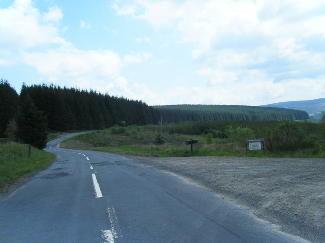
Whiteyett Plantation is a picturesque woodland located in Dumfriesshire, Scotland. Covering an area of approximately 200 acres, it is nestled in the stunning countryside, offering visitors a tranquil and serene environment.

The plantation is primarily composed of a diverse range of trees, including oak, beech, birch, and pine, creating a rich and varied ecosystem. The dense foliage provides a natural habitat for numerous species of birds, mammals, and insects, making it a haven for wildlife enthusiasts and nature lovers.

Visitors to Whiteyett Plantation can enjoy a network of well-maintained footpaths that wind through the woodlands, allowing for pleasant walks and hikes. The paths are clearly marked and provide breathtaking views of the surrounding countryside, making it an ideal spot for outdoor activities such as jogging, cycling, or picnicking.

In addition to its natural beauty, Whiteyett Plantation also holds historical significance. It was once part of the extensive estates owned by the local gentry and played a role in the region's timber industry. Although the plantation is no longer actively managed for timber production, remnants of its past can still be seen in the form of old logging tracks and the occasional sawmill ruins.

Whiteyett Plantation is a cherished local attraction, offering a peaceful retreat from the hustle and bustle of everyday life. Its combination of stunning scenery, diverse wildlife, and historical charm make it a must-visit destination for those seeking a connection with nature and a glimpse into the region's past.

If you have any feedback on the listing, please let us know in the comments section below.

Whiteyett Plantation Images

Images are sourced within 2km of 55.234207/-3.1871428 or Grid Reference NY2493. Thanks to Geograph Open Source API. All images are credited.

Minor road near to Bessie's Hill Car Park Looking south-westward.
Minor road near to Bessie's Hill Car Park
Looking south-westward.
Minor road near to Bessie's Hill Car Park Looking north-eastward.
Minor road near to Bessie's Hill Car Park
Looking north-eastward.
Minor road near to White Haugh Looking north-eastward.
Minor road near to White Haugh
Looking north-eastward.
Minor road approaching Castle O'er Looking southward from the car park entrance.
Minor road approaching Castle O'er
Looking southward from the car park entrance.
The B709 southwest of Allangillfoot
View from B709
View from B709
Bessie's Hill car park The footpath to Bessie's Hill Settlement and Fort starts from here.
Bessie's Hill car park
The footpath to Bessie's Hill Settlement and Fort starts from here.
Minor road by Castle O'er
B709 southbound near Allangillfoot
B709 south of Toothope Hill
Track from Road to Whiteyett Looking eastward towards the White Esk River.
Track from Road to Whiteyett
Looking eastward towards the White Esk River.
Ordnance Survey Flush Bracket 12099 This can be found on the wall of a private dwelling at Whiteyett.
For more detail see : <span class="nowrap"><a title="http://www.bench-marks.org.uk/bm22781" rel="nofollow ugc noopener" href="http://www.bench-marks.org.uk/bm22781">Link</a><img style="margin-left:2px;" alt="External link" title="External link - shift click to open in new window" src="https://s1.geograph.org.uk/img/external.png" width="10" height="10"/></span>
Ordnance Survey Flush Bracket 12099
This can be found on the wall of a private dwelling at Whiteyett. For more detail see : LinkExternal link
Cottage at Castle Oer
Water supply installation at Castle O'er The notice on the door reads "Scottish Water: White Esk SR Regulatory Final Sample Point".
Water supply installation at Castle O'er
The notice on the door reads "Scottish Water: White Esk SR Regulatory Final Sample Point".
Slippery Knowe Looking across the River White Esk to Slippery Knowe, a grassy hillside in the middle of Castle O'er Forest
Slippery Knowe
Looking across the River White Esk to Slippery Knowe, a grassy hillside in the middle of Castle O'er Forest
Slippery Knowe Looking across the River White Esk (hidden) to Slippery Knowe, a grassy hillside in the middle of Castle O'er Forest.
Slippery Knowe
Looking across the River White Esk (hidden) to Slippery Knowe, a grassy hillside in the middle of Castle O'er Forest.
Castlehill Cottage Isolated cottage on the minor road on the west bank of the River White Esk.
Castlehill Cottage
Isolated cottage on the minor road on the west bank of the River White Esk.
Entrance to Bessie's Hill car park A forest car park on the west side of the River White Esk.
Entrance to Bessie's Hill car park
A forest car park on the west side of the River White Esk.
Show me another place!

Whiteyett Plantation is located at Grid Ref: NY2493 (Lat: 55.234207, Lng: -3.1871428)

Unitary Authority: Dumfries and Galloway

Police Authority: Dumfries and Galloway

What 3 Words

///scatters.clean.melons. Near Bentpath, Dumfries & Galloway

Related Wikis

Castle O'er Forest

Castle O'er Forest is a forest south of Eskdalemuir, Dumfries and Galloway, in southern Scotland. It is bisected by the River Esk. Eskdalemuir Forest adjoins...

Girdle Stanes

The Girdle Stanes (grid reference NY 25351 96153) is a stone circle near Eskdalemuir, Dumfries and Galloway. The western portion of the circle has been...

Loupin Stanes

The Loupin Stanes (grid reference NY25709663) is a stone circle near Eskdalemuir, Dumfries and Galloway. Oval in shape, it consists of twelve stones set...

Holm, Inverness

Holm is a small residential area in the south of the city of Inverness, Scotland. The area lies east of the River Ness. The most prominent structure in...

Nearby Amenities

Located within 500m of 55.234207,-3.1871428
Power: pole
Lat/Long: 55.2356918/-3.183589
Power: pole
Lat/Long: 55.235779/-3.1821352
Power: pole
Lat/Long: 55.2358447/-3.1805956
The data included in this document is from www.openstreetmap.org. The data is made available under ODbL.

Have you been to Whiteyett Plantation?

Leave your review of Whiteyett Plantation below (or comments, questions and feedback).