Blaeberry Wood

Wood, Forest in Peeblesshire

Scotland

Blaeberry Wood

Frosty viewpoint to Haystoun A bench on the track near Cademuir Forest car park in cold settled weather.
Frosty viewpoint to Haystoun Credit: Jim Barton

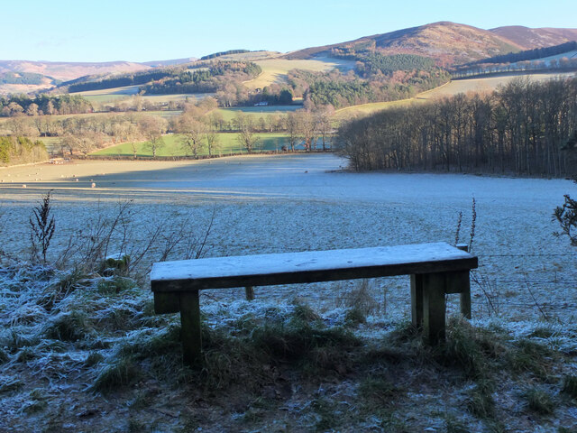
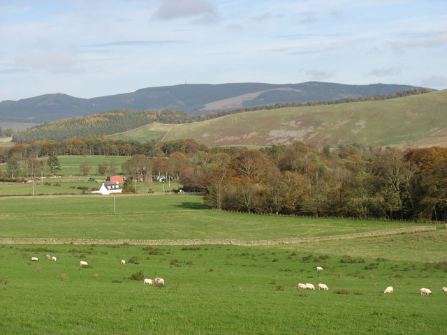
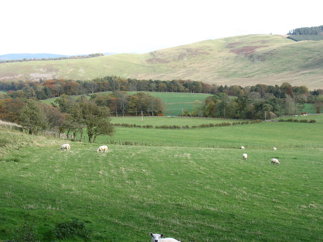
Blaeberry Wood is a charming forest located in Peeblesshire, a historic county in the Scottish Borders region of Scotland. The wood covers an area of approximately 100 acres and is renowned for its natural beauty and diverse flora and fauna.

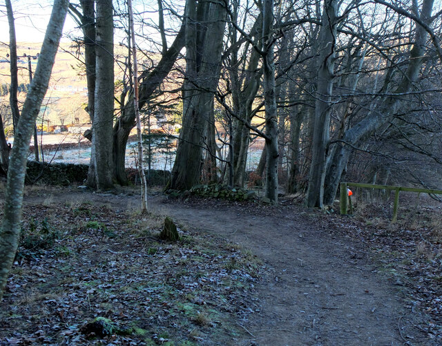
The wood is predominantly composed of native broadleaf trees such as oak, ash, and birch, providing a rich habitat for a wide range of wildlife. Visitors to Blaeberry Wood can enjoy the tranquil atmosphere as they wander through the well-maintained paths that crisscross the forest. The lush greenery and the melodic songs of birds create a peaceful and immersive experience for nature lovers and hikers alike.

One of the highlights of Blaeberry Wood is the abundant presence of blaeberry bushes, from which the wood gets its name. These bushes produce small, delicious blueberries, which attract foragers and wildlife, adding to the forest's natural charm.

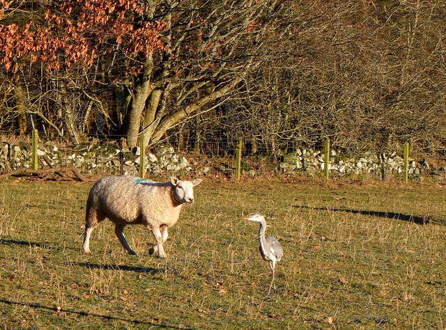
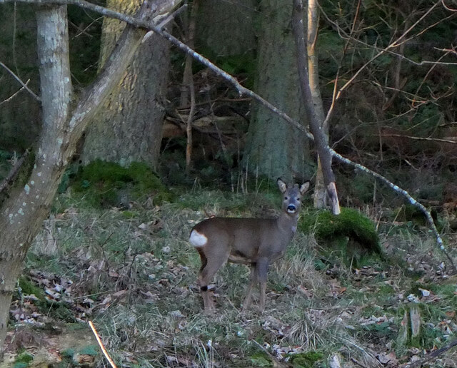
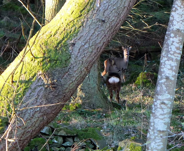
The wood is also home to a variety of animal species, including deer, foxes, badgers, and a multitude of bird species. Nature enthusiasts can often spot these animals in their natural habitat, making it a perfect location for wildlife photography and observation.

Blaeberry Wood is easily accessible, with well-marked trails and ample parking facilities. It is a popular destination for locals and visitors alike, offering a peaceful retreat from the hustle and bustle of everyday life. Whether you are looking for a leisurely stroll, a picnic spot, or a chance to immerse yourself in nature, Blaeberry Wood in Peeblesshire is a must-visit destination.

If you have any feedback on the listing, please let us know in the comments section below.

Blaeberry Wood Images

Images are sourced within 2km of 55.638603/-3.2255749 or Grid Reference NT2239. Thanks to Geograph Open Source API. All images are credited.

Frosty viewpoint to Haystoun A bench on the track near Cademuir Forest car park in cold settled weather.
Frosty viewpoint to Haystoun
A bench on the track near Cademuir Forest car park in cold settled weather.
The sheep and the heron An inquisitive ewe taking a look at a heron in a pasture near Bonnington farm.
The sheep and the heron
An inquisitive ewe taking a look at a heron in a pasture near Bonnington farm.
Roe deer, Cademuir Forest A roe deer not far from the track contouring the east edge of the woodland.
Roe deer, Cademuir Forest
A roe deer not far from the track contouring the east edge of the woodland.
Two roe deer, Cademuir Forest I spotted one deer by the track here <a href="https://www.geograph.org.uk/photo/7692276">NT2438 : Roe deer, Cademuir Forest</a>, then saw a second animal. They stayed long enough for a quick portrait.
Two roe deer, Cademuir Forest
I spotted one deer by the track here NT2438 : Roe deer, Cademuir Forest, then saw a second animal. They stayed long enough for a quick portrait.
Path to Craigerne A path through a strip wood to the houses at Craigerne on the south edge of Peebles. Note the orienteering marker at the fence corner.
Path to Craigerne
A path through a strip wood to the houses at Craigerne on the south edge of Peebles. Note the orienteering marker at the fence corner.
Warning of sheep chasing by dogs A notice on a field gatepost publicising the loss of five lambs to loose or out-of-control dogs, dated 8 June 2011.
Warning of sheep chasing by dogs
A notice on a field gatepost publicising the loss of five lambs to loose or out-of-control dogs, dated 8 June 2011.
Iron Age hill fort defences on Cademuir The scattered boulders in the grass, beyond the nearest fringe of loose boulders, have been embedded across the ridge to impede attackers on foot or horseback - there are over 60 in this view, protruding up to 50cm or so above ground. Obstacles such as this are known as 'chevaux de frise' and the concept was still used in the Second World War in the form of large concrete anti-tank defences around our coasts.

<a href="https://www.geograph.org.uk/photo/1540932">NT2237 : Iron Age defensive structure, Cademuir Hill Fort</a> shows a different view of these defences.
Iron Age hill fort defences on Cademuir
The scattered boulders in the grass, beyond the nearest fringe of loose boulders, have been embedded across the ridge to impede attackers on foot or horseback - there are over 60 in this view, protruding up to 50cm or so above ground. Obstacles such as this are known as 'chevaux de frise' and the concept was still used in the Second World War in the form of large concrete anti-tank defences around our coasts. NT2237 : Iron Age defensive structure, Cademuir Hill Fort shows a different view of these defences.
Plaque on the Manor Bridge over the Tweed The plaque is on the SW side of the bridge. Its lettering is not too clear, but reads:

THIS BRIDGE
ERECTED BY THE COUNTY AND PRIVATE SUBSCRIBERS
WAS OPENED BY
MISS PRINGLE KIDD OF WOODHOUSE
AND NAMED BY HER
MANOR BRIDGE
20TH MARCH 1883
Plaque on the Manor Bridge over the Tweed
The plaque is on the SW side of the bridge. Its lettering is not too clear, but reads: THIS BRIDGE ERECTED BY THE COUNTY AND PRIVATE SUBSCRIBERS WAS OPENED BY MISS PRINGLE KIDD OF WOODHOUSE AND NAMED BY HER MANOR BRIDGE 20TH MARCH 1883
Cutting hay at Edderston near Peebles The red tractor is pulling the baling machine, and two more tractors are loading and carting the bales to the farm nearby. Left of centre is a flock of blackheaded gulls that have been feeding on the cut field. Lee Pen is the hill in the background.
Cutting hay at Edderston near Peebles
The red tractor is pulling the baling machine, and two more tractors are loading and carting the bales to the farm nearby. Left of centre is a flock of blackheaded gulls that have been feeding on the cut field. Lee Pen is the hill in the background.
Manor Brig 18th Century bridge, Manor, Peebles.
Manor Brig
18th Century bridge, Manor, Peebles.
Sheepdog trials, Manor A damp day for the sheepdog trials at Woodhouse farm, Kirkton Manor. A simultaneous event is the Manor Water Hill Race, which starts from an adjacent field for a 10 mile round trip up to the summit of The Scrape (719m) and back.
Sheepdog trials, Manor
A damp day for the sheepdog trials at Woodhouse farm, Kirkton Manor. A simultaneous event is the Manor Water Hill Race, which starts from an adjacent field for a 10 mile round trip up to the summit of The Scrape (719m) and back.
Dog versus sheep, Manor Sheepdog trials at Woodhouse farm near Kirkton Manor; who is in charge here - man, dog, or sheep?
Dog versus sheep, Manor
Sheepdog trials at Woodhouse farm near Kirkton Manor; who is in charge here - man, dog, or sheep?
In the Manor Valley Looking towards Hallyards Farm
In the Manor Valley
Looking towards Hallyards Farm
Near Caverhill, Manor Valley Cademuir Hill is on the far side of the valley.
Near Caverhill, Manor Valley
Cademuir Hill is on the far side of the valley.
Manor Church, Kirkton Manor The church bell dates from 1485 and is one of the oldest, if not the oldest, in Scotland.
Manor Church, Kirkton Manor
The church bell dates from 1485 and is one of the oldest, if not the oldest, in Scotland.
A minor road to Peebles This road is seen leaving Kirkton Manor.
A minor road to Peebles
This road is seen leaving Kirkton Manor.
Old Manor Brig, built 1702 This bridge over Manor Water is now structurally unsound, and is open only to pedestrians and cyclists. Vehicular traffic crosses the Tweed nearby, and reaches Peebles on the north side of that river.
Old Manor Brig, built 1702
This bridge over Manor Water is now structurally unsound, and is open only to pedestrians and cyclists. Vehicular traffic crosses the Tweed nearby, and reaches Peebles on the north side of that river.
Manor Bridge This elegant bridge over the River Tweed was built in 1873 to serve the Manor valley, a cul-de-sac about 8 miles long. Prior to that, access was via the Old Manor Brig <a href="https://www.geograph.org.uk/photo/2694754">NT2339 : Old Manor Brig, built 1702</a>, now closed to all except pedestrians and cyclists, and a minor road to Peebles by way of Manor Sware.
Manor Bridge
This elegant bridge over the River Tweed was built in 1873 to serve the Manor valley, a cul-de-sac about 8 miles long. Prior to that, access was via the Old Manor Brig NT2339 : Old Manor Brig, built 1702, now closed to all except pedestrians and cyclists, and a minor road to Peebles by way of Manor Sware.
Show me another place!

Blaeberry Wood is located at Grid Ref: NT2239 (Lat: 55.638603, Lng: -3.2255749)

Unitary Authority: The Scottish Borders

Police Authority: The Lothians and Scottish Borders

What 3 Words

///smarting.organic.dwelled. Near Peebles, Scottish Borders

Related Wikis

Manor Water

Manor Water is a river in the parish of Manor, Peeblesshire in the Scottish Borders. It rises in the Ettrick Forest and flows down through the Maynor valley...

John Buchan Way

The John Buchan Way is a walking route from Peebles to Broughton in the Scottish Borders, a distance of approximately 22 km (13 miles). The route is waymarked...
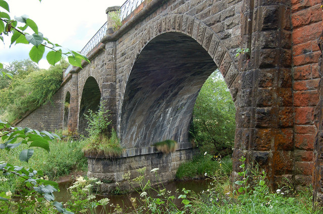
Neidpath Viaduct

Neidpath Viaduct, occasionally known as the Queen's Bridge, consists of eight stone skew arches and was built to carry the Symington to Peebles branch...

Manor, Scottish Borders

Manor is a parish in Peeblesshire in the Scottish Borders, whose church lies on the west bank of Manor Water 3 miles south-west of Peebles.The parish...

Neidpath Castle

Neidpath Castle is an L-plan rubble-built tower house, overlooking the River Tweed about 1 mile (1.6 km) west of Peebles in the Borders of Scotland. The...
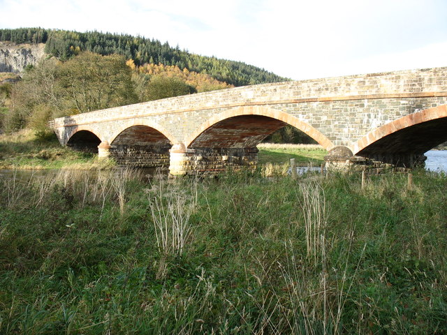
Lyne Viaduct

Lyne Viaduct is a viaduct at Lyne in the Scottish Borders of Scotland. It consists of three stone skew arches and a plate girder approach span over a minor...

Peebles High School, Peeblesshire

Peebles High School is a state run comprehensive school for girls and boys aged 12–18 located in Peebles in the Scottish Borders. It was originally named...
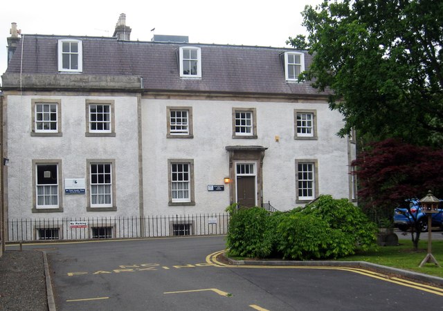
Hay Lodge Hospital

Hay Lodge Hospital is a health facility at Neidpath Road in Peebles, Scotland. It is managed by NHS Borders. Hay Lodge is a Category B listed building...

Nearby Amenities

Located within 500m of 55.638603,-3.2255749
Barrier: width restrictor
Width: 1.8
Lat/Long: 55.6418687/-3.2233461
Barrier: width restrictor
Width: 1.8
Lat/Long: 55.6421606/-3.2230308
Barrier: stile
Lat/Long: 55.6424947/-3.2257514
Barrier: log
Lat/Long: 55.6417798/-3.224345
Surface: asphalt
Traffic Calming: bump
Lat/Long: 55.6422284/-3.2229353
Power: pole
Lat/Long: 55.6342612/-3.2236026
Power: pole
Lat/Long: 55.6347937/-3.223702
The data included in this document is from www.openstreetmap.org. The data is made available under ODbL.

Have you been to Blaeberry Wood?

Leave your review of Blaeberry Wood below (or comments, questions and feedback).