Hass Plantation

Wood, Forest in Dumfriesshire

Scotland

Hass Plantation

Benchmark, Wamphray, Parish Church Detail of the Ordnance Survey cut benchmark on the south east corner of Wamphray Parish Church. The benchmark marks a height of 131.1859m above sea level (Ordnance Datum Newlyn) last verified in 1954 (location photograph <a href="https://www.geograph.org.uk/photo/6503278">NY1396 : Ordnance Survey benchmark, Wamphray Parish Church</a>).
Benchmark, Wamphray, Parish Church Credit: Adrian Taylor

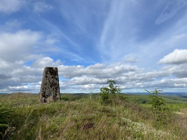
Hass Plantation, located in Dumfriesshire, Scotland, is a picturesque woodland area known for its breathtaking natural beauty and diverse range of flora and fauna. Spanning over a vast area, the plantation is a popular destination for nature enthusiasts, hikers, and photographers.

The plantation is predominantly composed of a mix of native tree species, including oak, beech, and birch, creating a dense and vibrant forest canopy. The woodland floor is adorned with a carpet of wildflowers, ferns, and mosses, adding to the enchanting atmosphere of the area.

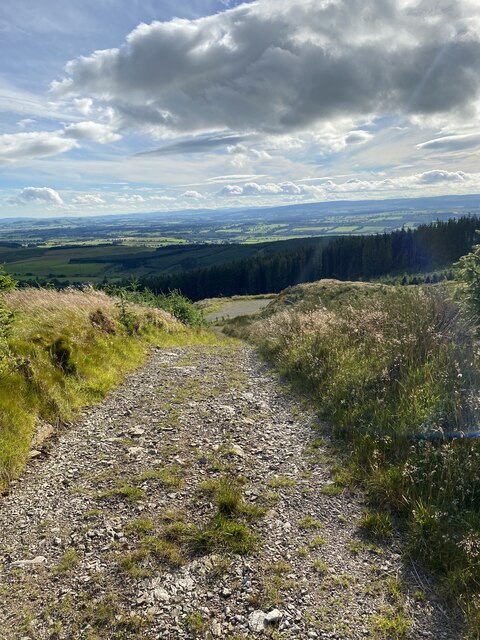
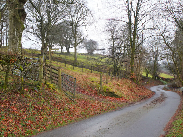
The plantation is crisscrossed by a network of well-maintained trails, providing visitors with the opportunity to explore the area at their own pace. These trails lead to various points of interest, including a tranquil river that meanders through the plantation, offering a serene spot for picnicking or simply enjoying the peaceful sounds of nature.

Hass Plantation is also home to a rich variety of wildlife. Visitors may spot red squirrels, deer, and a wide array of bird species, including woodpeckers and owls. Nature lovers are encouraged to bring their binoculars and cameras to capture the diverse wildlife that inhabits this woodland sanctuary.

In addition to its natural wonders, the plantation boasts a visitor center that provides information about the flora and fauna found in the area. It also offers guided tours and educational programs, allowing visitors to learn more about the plantation's conservation efforts and the importance of preserving such ecosystems.

Overall, Hass Plantation in Dumfriesshire is a haven for nature enthusiasts, offering a tranquil retreat amidst the beauty of the Scottish countryside.

If you have any feedback on the listing, please let us know in the comments section below.

Hass Plantation Images

Images are sourced within 2km of 55.244806/-3.3662559 or Grid Reference NY1395. Thanks to Geograph Open Source API. All images are credited.

Benchmark, Wamphray, Parish Church Detail of the Ordnance Survey cut benchmark on the south east corner of Wamphray Parish Church. The benchmark marks a height of 131.1859m above sea level (Ordnance Datum Newlyn) last verified in 1954 (location photograph <a href="https://www.geograph.org.uk/photo/6503278">NY1396 : Ordnance Survey benchmark, Wamphray Parish Church</a>).
Benchmark, Wamphray, Parish Church
Detail of the Ordnance Survey cut benchmark on the south east corner of Wamphray Parish Church. The benchmark marks a height of 131.1859m above sea level (Ordnance Datum Newlyn) last verified in 1954 (location photograph NY1396 : Ordnance Survey benchmark, Wamphray Parish Church).
Fingland Fell Trig Point Flush Bracket S7703
Short section of steep track on descent from Fingland Fell
Fingland Red Cleuch
Fingland Red Cleuch
Gate at start of track to Fingland Fell
Start of the path, Wamphray Glen An information board near the road junction at Wamphray Bridge. There is room to park a few cars nearby.
Start of the path, Wamphray Glen
An information board near the road junction at Wamphray Bridge. There is room to park a few cars nearby.
The Wamphray Water Spring growth appearing in the woodland on the banks with Wamphray Bridge in the background.
The Wamphray Water
Spring growth appearing in the woodland on the banks with Wamphray Bridge in the background.
Footbridge over the Wamphray Water The path up the glen crosses here to follow the north bank of the Wamphray Water.
Footbridge over the Wamphray Water
The path up the glen crosses here to follow the north bank of the Wamphray Water.
The Wamphray Water from the footbridge Looking upstream from the bridge on the Wamphray Glen path.
The Wamphray Water from the footbridge
Looking upstream from the bridge on the Wamphray Glen path.
Field path by the Wamphray Water The Wamphray Glen path climbs to the top of the northern bank to follow the woodland edge towards Wamphray Mill.
Field path by the Wamphray Water
The Wamphray Glen path climbs to the top of the northern bank to follow the woodland edge towards Wamphray Mill.
Cascades on the Wamphray Water The path up the glen follows the steep edge of the bank with the river rushing past below.
Cascades on the Wamphray Water
The path up the glen follows the steep edge of the bank with the river rushing past below.
Wamphray Glen path The path follows the top  of the steep bank with a  wooden fence and steps in places, giving dramatic glimpses of the Wamphray Water.
Wamphray Glen path
The path follows the top of the steep bank with a wooden fence and steps in places, giving dramatic glimpses of the Wamphray Water.
Footbridge over the Leithenhall Burn The Wamphray Glen path descends to cross here to reach the bridge over the Wamphray Water (R).
Footbridge over the Leithenhall Burn
The Wamphray Glen path descends to cross here to reach the bridge over the Wamphray Water (R).
Bridge near Wamphray Mill The minor road from Pumplaburn crosses to join the road below Wamphray Kirk. The former Wamphray Mill is in the background.
Bridge near Wamphray Mill
The minor road from Pumplaburn crosses to join the road below Wamphray Kirk. The former Wamphray Mill is in the background.
Churchyard gate, Wamphray A steel gate with designs recalling the woodlands by the river, at Wamphray Parish Church. See also Gordon Brown's photograph (2008): <a href="https://www.geograph.org.uk/photo/1055292">NY1396 : Elegant new gate at Wamphrey church</a>.
Churchyard gate, Wamphray
A steel gate with designs recalling the woodlands by the river, at Wamphray Parish Church. See also Gordon Brown's photograph (2008): NY1396 : Elegant new gate at Wamphrey church.
Graveyard at Wamphray Parish Church A quiet country graveyard overlooking the valley of the Wamphray Water.
Graveyard at Wamphray Parish Church
A quiet country graveyard overlooking the valley of the Wamphray Water.
Wamphray Parish Church The building dates from 1834, replacing an earlier church.
Wamphray Parish Church
The building dates from 1834, replacing an earlier church.
Path to Kirkhill The Wamphray Glen path leaves the road at Charter Cleuch to cross farmland to Kirkhill on the return leg to Wamphray Bridge.
Path to Kirkhill
The Wamphray Glen path leaves the road at Charter Cleuch to cross farmland to Kirkhill on the return leg to Wamphray Bridge.
Show me another place!

Hass Plantation is located at Grid Ref: NY1395 (Lat: 55.244806, Lng: -3.3662559)

Unitary Authority: Dumfries and Galloway

Police Authority: Dumfries and Galloway

What 3 Words

///tanked.octagon.configure. Near Johnstonebridge, Dumfries & Galloway

Nearby Locations

Hass Plantation

Related Wikis

Wamphray railway station

Wamphray railway station served Newton Wamphray, near Beattock, in the Scottish county of Dumfries and Galloway. It was served by local trains on what...

Newton Wamphray

Newton Wamphray is a village in Dumfries and Galloway. Wamphray is the name of the surrounding parish and of the Wamphray Water, which flows south-west...

Annandale Water services

Annandale Water services is a motorway service station in the village of Johnstonebridge, Scotland. The service station is located next to the A74(M) motorway...

Annandale Water

Annandale Water is a loch in Annandale, Dumfries and Galloway, in the south west of Scotland. It is part of Annandale Water service station at Junction...

Nearby Amenities

Located within 500m of 55.244806,-3.3662559
Design: barrel
Power: tower
Lat/Long: 55.2470586/-3.3729381
Design: barrel
Power: tower
Lat/Long: 55.2454755/-3.3689476
Design: barrel
Power: tower
Lat/Long: 55.2417339/-3.3625239
Design: barrel
Power: tower
Lat/Long: 55.243935/-3.3662907
Power: pole
Lat/Long: 55.2431726/-3.3667627
Power: pole
Lat/Long: 55.2436631/-3.3675973
Power: pole
Lat/Long: 55.2441594/-3.368383
Power: pole
Lat/Long: 55.2448481/-3.3693593
Power: pole
Lat/Long: 55.2450728/-3.3697405
Power: pole
Lat/Long: 55.2456088/-3.3709487
Power: pole
Lat/Long: 55.246133/-3.3721001
The data included in this document is from www.openstreetmap.org. The data is made available under ODbL.

Have you been to Hass Plantation?

Leave your review of Hass Plantation below (or comments, questions and feedback).