Shepherdlands Wood

Wood, Forest in Fife

Scotland

Shepherdlands Wood

Harvest stored near Kinneddar Park Silage bales - not sure if the wrapping colour is of any significance?
Harvest stored near Kinneddar Park Credit: M J Richardson

The requested URL returned error: 429 Too Many Requests

If you have any feedback on the listing, please let us know in the comments section below.

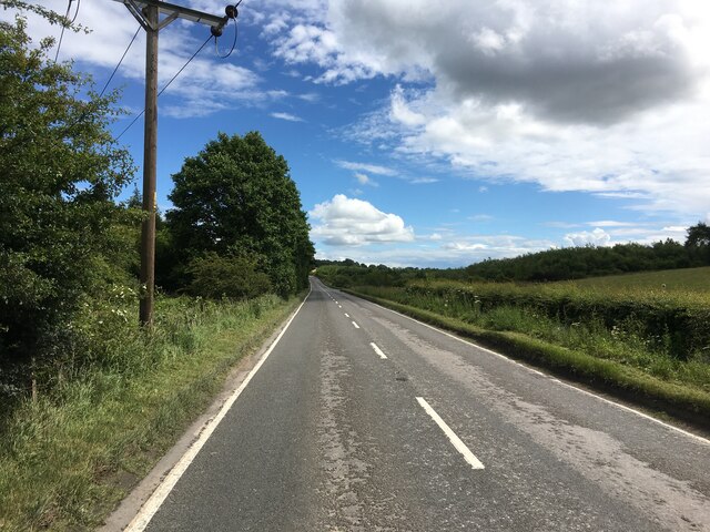
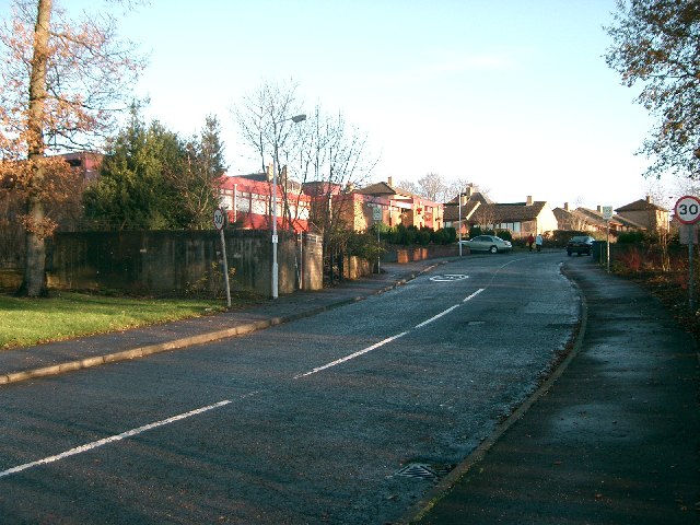
Shepherdlands Wood Images

Images are sourced within 2km of 56.094617/-3.6040971 or Grid Reference NT0090. Thanks to Geograph Open Source API. All images are credited.

Harvest stored near Kinneddar Park Silage bales - not sure if the wrapping colour is of any significance?
Harvest stored near Kinneddar Park
Silage bales - not sure if the wrapping colour is of any significance?
Sheep pasture at Muirside of Kinneddar
Grass fields at Kinneddar Park Possibly the source of the silage at <a href="https://www.geograph.org.uk/photo/6291724">NT0290 : Harvest stored near Kinneddar Park</a>.
Grass fields at Kinneddar Park
Possibly the source of the silage at NT0290 : Harvest stored near Kinneddar Park.
A907 towards Dunfermline
Fife pastures On the coal measures where the ground is often wet.
Fife pastures
On the coal measures where the ground is often wet.
Road to Bickramside This was the access road to Comrie Colliery.
Road to Bickramside
This was the access road to Comrie Colliery.
Kinneddar Park
Kinneddar Park
A907 at Mains of Comrie
A907 near Comrie
A907 near Comrie
Housing At Kinneddar Park.
Housing
At Kinneddar Park.
Pigeon Lofts Kinneddar Park Lofts where some of the members of Oakley Pigeon Club keep their doos.
Pigeon Lofts
Kinneddar Park Lofts where some of the members of Oakley Pigeon Club keep their doos.
Ruined House Named on the map as Sunnyside.
Ruined House
Named on the map as Sunnyside.
Countryside Looking north east across the square to Big Wood and Saline Hill.
Countryside
Looking north east across the square to Big Wood and Saline Hill.
Comrie Colliery This is some of what remains of Comrie Colliery which operated on this site from 1935 to 1986. The entrance has been blocked to prevent illegal dumping.
Comrie Colliery
This is some of what remains of Comrie Colliery which operated on this site from 1935 to 1986. The entrance has been blocked to prevent illegal dumping.
Derelict Building This is some of what remains of Comrie Colliery which operated on this site from 1935 to 1986.
Derelict Building
This is some of what remains of Comrie Colliery which operated on this site from 1935 to 1986.
Comrie Colliery This is some of what remains of Comrie Colliery which operated here from 1935 to 1986.
Comrie Colliery
This is some of what remains of Comrie Colliery which operated here from 1935 to 1986.
The auld hoose, Blairhall Doon the red ash road to Comrie pit
The auld hoose, Blairhall
Doon the red ash road to Comrie pit
Comrie Colliery Ruins of surface buildings at Comrie which was closed down in 1986. There was a lot of activity in the area suggesting some form of redevelopment.
Comrie Colliery
Ruins of surface buildings at Comrie which was closed down in 1986. There was a lot of activity in the area suggesting some form of redevelopment.
Show me another place!

Shepherdlands Wood is located at Grid Ref: NT0090 (Lat: 56.094617, Lng: -3.6040971)

Unitary Authority: Fife

Police Authority: Fife

What 3 Words

///crunches.jubilant.restores. Near Oakley, Fife

Nearby Locations

Shepherdlands Wood

Related Wikis

Blairhall

Blairhall is a village in West Fife, Scotland. It is situated 1.1 miles (1.77 km) west of Comrie, and 6.7 miles (10.783 km) west of Dunfermline. The village...

East Grange (Fife) railway station

East Grange railway station served the area of East Grange, Fife, Scotland, from 1850 to 1958 on the Stirling and Dunfermline Railway. == History == The...

Comrie, Fife

Comrie ( locally or ); is a village in Fife, Scotland, located immediately west of the neighbouring village of Oakley, 6.2 miles (9.98 km) west of Dunfermline...

Oakley United F.C.

Oakley United Football Club are a Scottish football club based in Oakley, Fife. Formed in 1964, they play their home games at Blairwood Park. The club...

Nearby Amenities

Located within 500m of 56.094617,-3.6040971
Man Made: mast
Source: survey
Lat/Long: 56.096151/-3.6085138
Man Made: tower
Tower Type: communication
Lat/Long: 56.0921415/-3.6053798
Bus Stop
Blairhall Primary School
Bus: yes
Naptan AtcoCode: 6500D9631
Naptan NaptanCode: 34346765
Public Transport: platform
Lat/Long: 56.0904494/-3.6013503
Generator Method: photovoltaic
Generator Output Electricity: yes
Generator Source: solar
Generator Type: solar_photovoltaic_panel
Power: generator
Lat/Long: 56.0912383/-3.6056551
Traffic Calming: cushion
Lat/Long: 56.0909548/-3.5999445
Generator Method: photovoltaic
Generator Output Electricity: yes
Generator Source: solar
Generator Type: solar_photovoltaic_panel
Power: generator
Lat/Long: 56.090776/-3.6058244
Material: wood
Power: pole
Lat/Long: 56.0913775/-3.5987387
Material: wood
Power: pole
Lat/Long: 56.0914736/-3.5993315
Material: wood
Power: pole
Lat/Long: 56.0916659/-3.6008045
Material: wood
Power: pole
Lat/Long: 56.0918203/-3.6019963
Power: pole
Lat/Long: 56.0913923/-3.6027082
The data included in this document is from www.openstreetmap.org. The data is made available under ODbL.

Have you been to Shepherdlands Wood?

Leave your review of Shepherdlands Wood below (or comments, questions and feedback).