Dalreoch Wood

Wood, Forest in Inverness-shire

Scotland

Dalreoch Wood

Tree surgery holds up the traffic near Balmore
Tree surgery holds up the traffic near Balmore Credit: Alan Reid

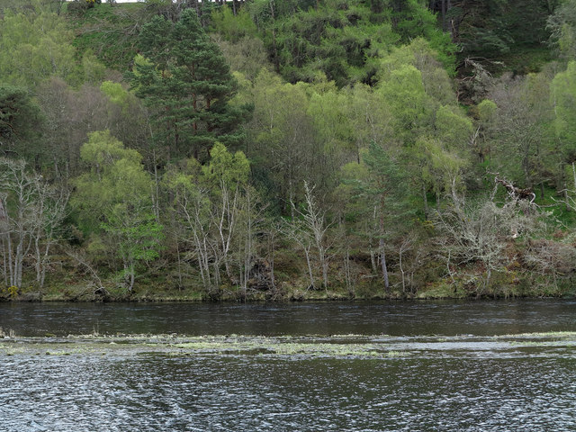
Dalreoch Wood is a picturesque woodland located in Inverness-shire, Scotland. Situated near the village of Inverfarigaig, this natural haven is renowned for its stunning beauty and diverse range of flora and fauna.

Covering an area of approximately 50 acres, Dalreoch Wood is predominantly composed of native Scottish trees such as oak, birch, and pine. These trees create a dense canopy, providing a sheltered environment for a wide variety of wildlife. Visitors to the wood can expect to encounter species such as red squirrels, roe deer, and a multitude of bird species, including the elusive capercaillie.

The woodland is crisscrossed by a network of well-maintained footpaths, allowing visitors to explore its enchanting landscapes at their leisure. These pathways lead visitors through a tapestry of moss-covered rocks, babbling brooks, and vibrant wildflower meadows. The wood boasts several viewpoints that offer breathtaking vistas of the surrounding countryside, including stunning views of Loch Ness.

Dalreoch Wood is also steeped in history, with remnants of ancient settlements and burial sites scattered throughout the area. Archaeological finds, including stone tools and pottery shards, indicate human habitation in the wood dating back thousands of years.

Visitors to Dalreoch Wood can enjoy a range of outdoor activities, including walking, wildlife spotting, and picnicking. The wood provides a tranquil escape from the hustle and bustle of daily life, and its natural beauty makes it a popular destination for nature enthusiasts and photographers alike.

If you have any feedback on the listing, please let us know in the comments section below.

Dalreoch Wood Images

Images are sourced within 2km of 57.441516/-4.2887726 or Grid Reference NH6241. Thanks to Geograph Open Source API. All images are credited.

Tree surgery holds up the traffic near Balmore
Two waterways with trees beyond The division between the two waterways is apparent. The farther one is the River Ness soon after its leaving of Loch Dochfour; the nearer one is the start of a stretch of the Caledonian Canal as it heads towards Inverness. Shortly before the image was recorded two fishermen walked the way between the two channels seeming almost to be walking on water!
Two waterways with trees beyond
The division between the two waterways is apparent. The farther one is the River Ness soon after its leaving of Loch Dochfour; the nearer one is the start of a stretch of the Caledonian Canal as it heads towards Inverness. Shortly before the image was recorded two fishermen walked the way between the two channels seeming almost to be walking on water!
Farm road to Borlum
Farm road to Borlum
Shed at Scaniport
Shed at Scaniport
Scaniport Track to some hummocky fields (glacial deposition).
Scaniport
Track to some hummocky fields (glacial deposition).
Borlum Flooded ground near the River Ness at Borlum.
Borlum
Flooded ground near the River Ness at Borlum.
Shed at Scaniport A shed, some rubbish, and a ruin in the trees.
Shed at Scaniport
A shed, some rubbish, and a ruin in the trees.
The Caledonian Canal at Dochgarroch Just after the weir separates the flow from Loch Dochfour into the River Ness, from this point onwards Loch Dochfour becomes the Caledonian Canal
The Caledonian Canal at Dochgarroch
Just after the weir separates the flow from Loch Dochfour into the River Ness, from this point onwards Loch Dochfour becomes the Caledonian Canal
Dochgarroch Weir Loch Dochfour drains over the weir to the left, forming the River Ness, while the Caledonian Canal continues to the right. Lorries pass close by at this point on the busy A82 trunk road
Dochgarroch Weir
Loch Dochfour drains over the weir to the left, forming the River Ness, while the Caledonian Canal continues to the right. Lorries pass close by at this point on the busy A82 trunk road
Dochgarroch Weir Loch Dochfour drains over the weir to the left, forming the River Ness, while the Caledonian Canal continues to the right. The loch was fairly low with little water flowing over the weir, in comparison with this image taken in February 2019 <a href="https://www.geograph.org.uk/photo/6054581">NH6139 : Dochgarroch Weir</a>
Dochgarroch Weir
Loch Dochfour drains over the weir to the left, forming the River Ness, while the Caledonian Canal continues to the right. The loch was fairly low with little water flowing over the weir, in comparison with this image taken in February 2019 NH6139 : Dochgarroch Weir
View over Scaniport from the Trail of the 7 Lochs A spectacular view from the Trail of the 7 Lochs where it runs through a clear-felled section of Drumashie Plantation. Laggan House can be  partially viewed through the trees in the centre of the image
View over Scaniport from the Trail of the 7 Lochs
A spectacular view from the Trail of the 7 Lochs where it runs through a clear-felled section of Drumashie Plantation. Laggan House can be partially viewed through the trees in the centre of the image
View over Cullaird from the Trail of the 7 Lochs Viewed from the trail in the clear-felled Drumashie Plantation towards Cullaird Farm. The field in the right of the image was still ponding after a winter of continuous rainfall. 
The transmitter masts on the summit of Dunain Hill are visible on the skyline over 4km away
View over Cullaird from the Trail of the 7 Lochs
Viewed from the trail in the clear-felled Drumashie Plantation towards Cullaird Farm. The field in the right of the image was still ponding after a winter of continuous rainfall. The transmitter masts on the summit of Dunain Hill are visible on the skyline over 4km away
Farmland at Scaniport
Crops in field at Balmore
Entrance to Caledonian Canal at Dochfour
Lock at the foot of Loch Ness
General Wades Military Road near Scaniport Here the B862 from Inverness to Dores follows the line of General Wades Military Road. The road runs south-west across the corner of NH6336 and the (just visible) furthest point lies in NH6239.
General Wades Military Road near Scaniport
Here the B862 from Inverness to Dores follows the line of General Wades Military Road. The road runs south-west across the corner of NH6336 and the (just visible) furthest point lies in NH6239.
Radio masts on Dunain Hill
Show me another place!

Dalreoch Wood is located at Grid Ref: NH6241 (Lat: 57.441516, Lng: -4.2887726)

Unitary Authority: Highland

Police Authority: Highlands and Islands

What 3 Words

///revived.seemingly.science. Near Inverness, Highland

Nearby Locations

Dalreoch Wood Poulneat

Related Wikis

Dochgarroch

Dochgarroch (Scottish Gaelic: Dabhach Gairbheach) is a settlement that lies at the start of the Caledonian Canal, at the head of Loch Ness in Inverness...

Scaniport

Scaniport (Scottish Gaelic: Sganaphort) is a small settlement located on the B862, roughly between Inverness to the north and Dores to the south, in the...

Craig Dunain Hospital

Craig Dunain Hospital was a mental health facility near Inverness in Scotland. The former hospital is a Category B listed building. == History == The hospital...

Essich

Essich (, Scottish Gaelic: Easaich) is a region of Scotland located between Inverness and Loch Ness. It is located 2.7 kilometres from the centre of Inverness...

Nearby Amenities

Located within 500m of 57.441516,-4.2887726
Power: tower
Lat/Long: 57.4455953/-4.2876441
Power: tower
Lat/Long: 57.4443057/-4.2839743
The data included in this document is from www.openstreetmap.org. The data is made available under ODbL.

Have you been to Dalreoch Wood?

Leave your review of Dalreoch Wood below (or comments, questions and feedback).