Rocks Plantation

Wood, Forest in Renfrewshire

Scotland

Rocks Plantation

Blackbyers Road Looking downhill to a roundabout on Glasgow Road.
Blackbyers Road Credit: Richard Webb

Rocks Plantation is a stunning forest located in Renfrewshire, Scotland. Spanning over a vast area, the plantation is known for its diverse range of trees and natural beauty. The forest is situated in a picturesque landscape, with rolling hills and meandering streams adding to its charm.

The plantation is predominantly made up of oak trees, with their majestic presence creating a captivating atmosphere. These ancient oaks are often covered in moss and lichens, adding a touch of enchantment to the surroundings. The dense canopy created by the trees provides a cool and tranquil environment, making it a popular spot for nature lovers and hikers.

A network of walking trails crisscrosses the plantation, allowing visitors to explore and discover its hidden gems. These trails offer breathtaking views of the surrounding countryside, with glimpses of wildlife such as deer, squirrels, and a variety of bird species. The forest floor is covered in a carpet of wildflowers during spring and summer, further enhancing the area's natural beauty.

Rocks Plantation is not only a haven for nature enthusiasts but also serves as an important habitat for many species. The diverse range of trees provides shelter and sustenance for a variety of wildlife, contributing to the area's ecological significance.

Overall, Rocks Plantation in Renfrewshire is a must-visit destination for those seeking solace in nature. Its ancient oaks, scenic trails, and abundant wildlife create an idyllic setting for peaceful walks and a deeper connection with the natural world.

If you have any feedback on the listing, please let us know in the comments section below.

Rocks Plantation Images

Images are sourced within 2km of 55.827418/-4.3763531 or Grid Reference NS5161. Thanks to Geograph Open Source API. All images are credited.

Blackbyers Road Looking downhill to a roundabout on Glasgow Road.
Blackbyers Road
Looking downhill to a roundabout on Glasgow Road.
Roadside bath What was open on Open Day?  Redevelopment of the Spillers site? The bath is beside the barely used exit from a roundabout on Glasgow Road.
Roadside bath
What was open on Open Day? Redevelopment of the Spillers site? The bath is beside the barely used exit from a roundabout on Glasgow Road.
Blackbyres Road The road on the left is Blackbyres Court.
Blackbyres Road
The road on the left is Blackbyres Court.
Entrance to the Water Works, Barrhead One of a couple of entrances into the former water works (sewage works) site at Barrhead, now a site for Grow Wild Scotland.
Entrance to the Water Works, Barrhead
One of a couple of entrances into the former water works (sewage works) site at Barrhead, now a site for Grow Wild Scotland.
Spillers site, Barrhead Similar view to Richard Webb's in 2015 [<a title="https://www.geograph.org.uk/photo/4682074" href="https://www.geograph.org.uk/photo/4682074">Link</a>].
Spillers site, Barrhead
Similar view to Richard Webb's in 2015 [Link].
Salterland Road Looking along the road towards Salterland Farm, from where a car is just emerging.
Salterland Road
Looking along the road towards Salterland Farm, from where a car is just emerging.
Whitriggs Road, South Nitshill Seen from the end of the road. Being a dead end, it is always pretty quiet.
Whitriggs Road, South Nitshill
Seen from the end of the road. Being a dead end, it is always pretty quiet.
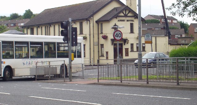
The Abbey Hotel, Paisley
Woodland Path Near Dykebar Hospital
Shaw Wood A much healthier looking wood than the Bull Wood in NS5162, with trees, mostly oak, of different ages.
Shaw Wood
A much healthier looking wood than the Bull Wood in NS5162, with trees, mostly oak, of different ages.
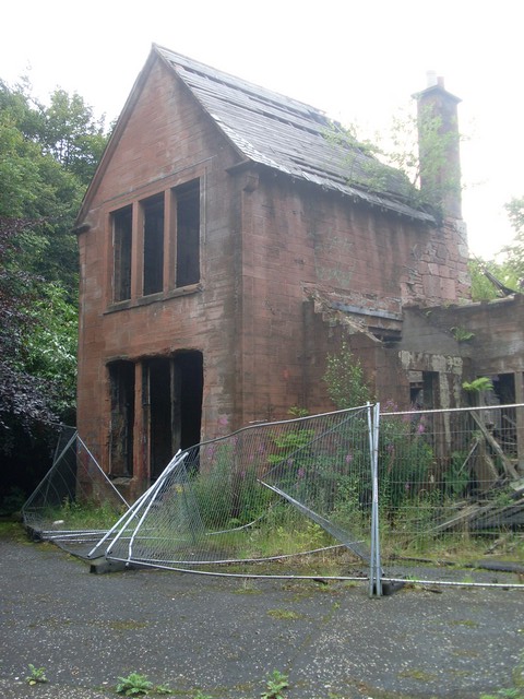
Hollybush The Timothy Pont and Blaeu maps show that there has been a building here called Hollybush for centuries ("Holynbus" or "Holmbuss") It has been derelict since at least the mid 20th century.
Hollybush
The Timothy Pont and Blaeu maps show that there has been a building here called Hollybush for centuries ("Holynbus" or "Holmbuss") It has been derelict since at least the mid 20th century.
Derelict flats, Todholm Road A row of boarded up or windowless flats overlooking the White Cart Water and what the 1:25,000 map shows as a nature reserve.
Derelict flats, Todholm Road
A row of boarded up or windowless flats overlooking the White Cart Water and what the 1:25,000 map shows as a nature reserve.
Millennium milepost In parkland off Todholm Road, Paisley.
Millennium milepost
In parkland off Todholm Road, Paisley.
Following the dismantled railway route From the bridge on Grahamston Road.
Following the dismantled railway route
From the bridge on Grahamston Road.
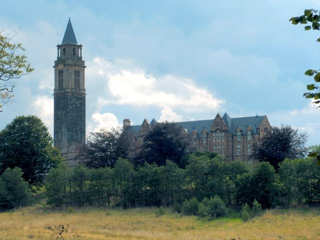
Dykebar Hospital Mental health hospital on the outskirts of Paisley.
Dykebar Hospital
Mental health hospital on the outskirts of Paisley.
Grounds of Dykebar Hospital
Derelict building in grounds of Dykebar Hospital
Steps up to Glenapp Avenue From Barrhead Road, near Hawkhead Roundabout.
Steps up to Glenapp Avenue
From Barrhead Road, near Hawkhead Roundabout.
Show me another place!

Rocks Plantation is located at Grid Ref: NS5161 (Lat: 55.827418, Lng: -4.3763531)

Unitary Authority: City of Glasgow

Police Authority: Greater Glasgow

What 3 Words

///unrealistic.reef.round. Near Paisley, Renfrewshire

Related Wikis

Nearby Amenities

Located within 500m of 55.827418,-4.3763531
Power: tower
Lat/Long: 55.8303928/-4.3817619
Power: tower
Lat/Long: 55.8275121/-4.3835821
Addr Housenumber: 17
Addr Street: Oldbar Road
Entrance: home
Lat/Long: 55.8284041/-4.3714389
Addr Housenumber: 79
Addr Street: Raeswood Road
Entrance: home
Lat/Long: 55.828612/-4.3719765
Addr Housenumber: 81
Addr Street: Raeswood Road
Entrance: home
Lat/Long: 55.8287166/-4.3718897
Addr Housenumber: 40
Addr Street: Oldbar Road
Entrance: home
Lat/Long: 55.8285743/-4.3711944
Addr Housenumber: 38
Addr Street: Oldbar Road
Entrance: home
Lat/Long: 55.8285389/-4.3710535
Addr Housenumber: 15
Addr Street: Oldbar Road
Entrance: home
Lat/Long: 55.8283663/-4.3711971
The data included in this document is from www.openstreetmap.org. The data is made available under ODbL.

Have you been to Rocks Plantation?

Leave your review of Rocks Plantation below (or comments, questions and feedback).