Bad nan Gad

Wood, Forest in Sutherland

Scotland

Bad nan Gad

Loch a' Mhinidh by the A894
Loch a' Mhinidh by the A894 Credit: Alan Reid

Bad nan Gad, located in Sutherland, Scotland, is a stunning woodland area known for its natural beauty and rich biodiversity. Nestled within the Scottish Highlands, this forested region covers a vast expanse of approximately 10 square kilometers. The name "Bad nan Gad" translates to "the clump of the withies" in Gaelic, a reference to the numerous willow trees that can be found throughout the area.

The woodland is characterized by a diverse range of tree species, including oak, birch, pine, and rowan, creating a picturesque and varied landscape. These trees provide a habitat for a wide array of wildlife, such as red deer, roe deer, foxes, and various bird species. It is not uncommon to spot a golden eagle soaring through the skies or to stumble upon the tracks of a shy pine marten.

The forest is crisscrossed by several walking trails, allowing visitors to explore its enchanting beauty firsthand. The paths wind through mossy glens and alongside babbling brooks, offering a tranquil and immersive experience in nature. In addition, the forest is home to several small lochs, adding to the overall charm and tranquility of the surroundings.

Bad nan Gad is a popular destination for nature enthusiasts, hikers, and photographers who seek to capture the raw beauty of the Scottish wilderness. Its remote location and untouched landscapes make it an idyllic retreat for those looking to escape the hustle and bustle of everyday life and immerse themselves in the serenity of nature.

If you have any feedback on the listing, please let us know in the comments section below.

Bad nan Gad Images

Images are sourced within 2km of 58.28135/-5.0692818 or Grid Reference NC2036. Thanks to Geograph Open Source API. All images are credited.
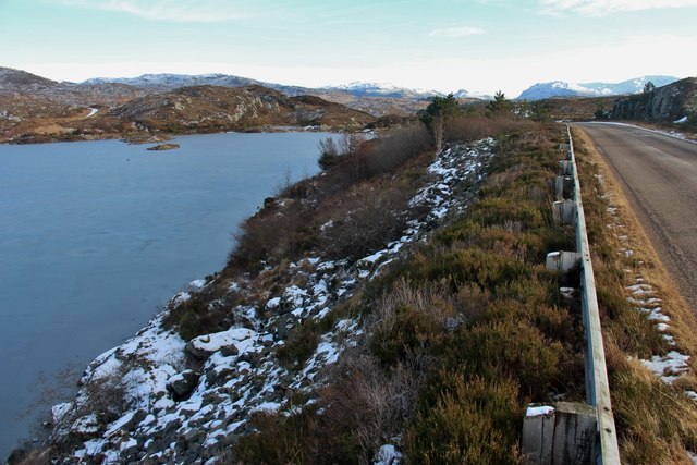
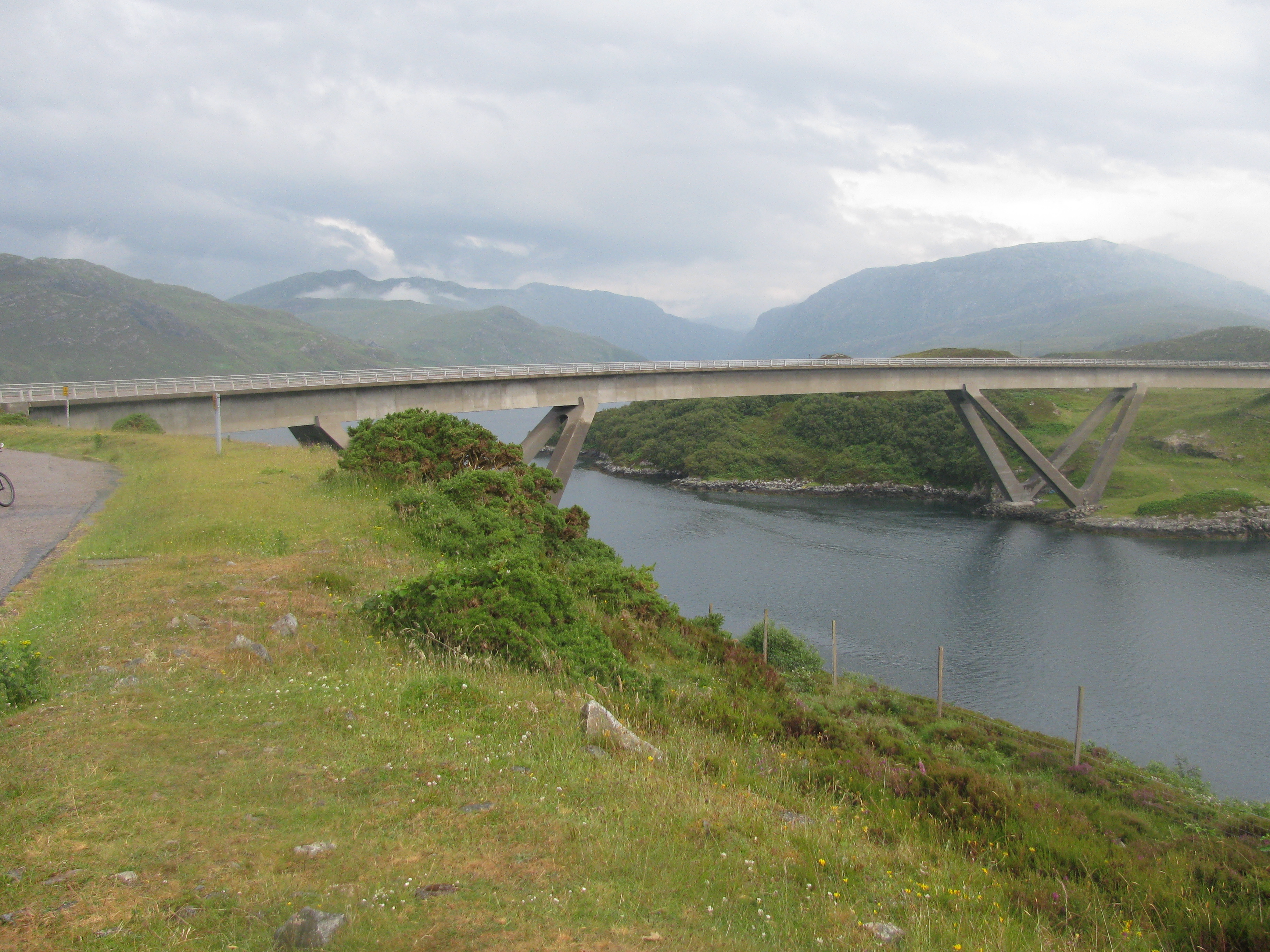
Loch a' Mhinidh by the A894
Summer Evening at Duartmore Point, Sutherland 
An uninhabited Scottish coastline of inlets and bays, bathed in golden evening sunlight on a summer evening.  The view is facing northwest over Duartmore Point towards the Hebridean Sea.  This area, known as the Assynt, is in the northwest corner of mainland Britain and daylight hours are long in summer.  This photo was taken at 9pm, about 1h30m before sunset.
Summer Evening at Duartmore Point, Sutherland
An uninhabited Scottish coastline of inlets and bays, bathed in golden evening sunlight on a summer evening. The view is facing northwest over Duartmore Point towards the Hebridean Sea. This area, known as the Assynt, is in the northwest corner of mainland Britain and daylight hours are long in summer. This photo was taken at 9pm, about 1h30m before sunset.
Duartmore Forest and Bay, Sutherland The west coast of Sutherland at Duartmore forest.  The nearby water is an unnamed loch.  The water beyond is the Hebridean Sea.
Duartmore Forest and Bay, Sutherland
The west coast of Sutherland at Duartmore forest. The nearby water is an unnamed loch. The water beyond is the Hebridean Sea.
Shooting Butts in Duartmore Forest, Sutherland An area of moorland with various screens or butts, presumably for visitors from the nearby forest lodge to participate in country sports.
Shooting Butts in Duartmore Forest, Sutherland
An area of moorland with various screens or butts, presumably for visitors from the nearby forest lodge to participate in country sports.
Track in Duartmore Forest, Sutherland This track runs from the A894 to a lodge in the forest.
Track in Duartmore Forest, Sutherland
This track runs from the A894 to a lodge in the forest.
New Track in the Duartmore Forest, Sutherland This new track serves a small new lodge in Duartmore Forest.  The water to the left is Loch Duartmore.
New Track in the Duartmore Forest, Sutherland
This new track serves a small new lodge in Duartmore Forest. The water to the left is Loch Duartmore.
Water Lilies on Loch an Ruighein, Duartmore Forest, Sutherland Loch an Ruighein is a tranquil but inaccessible loch, tucked away in the Duartmore Forest in the far north of the Scottish Highlands.  The Loch doesn't appear to be visited much - getting to it was quite a job, with boggy ground, dense vegetation and fallen trees.  Not surprising then that there were no other photos of it on Geograph.
Water Lilies on Loch an Ruighein, Duartmore Forest, Sutherland
Loch an Ruighein is a tranquil but inaccessible loch, tucked away in the Duartmore Forest in the far north of the Scottish Highlands. The Loch doesn't appear to be visited much - getting to it was quite a job, with boggy ground, dense vegetation and fallen trees. Not surprising then that there were no other photos of it on Geograph.
Log Cabin in Duartmore Forest, Sutherland Off grid and off the beaten track, this log cabin stands by itself in a secluded Sutherland forest.
Log Cabin in Duartmore Forest, Sutherland
Off grid and off the beaten track, this log cabin stands by itself in a secluded Sutherland forest.
Log track in Duartmore Forest A track made from logs laid crosswise in a very boggy area on the south side of the forest. It leads to the cabin shown in Andrew Tryon's photo <a href="https://www.geograph.org.uk/photo/5462360">NC1836 : Log Cabin in Duartmore Forest, Sutherland</a>, but evidently has not been used for some time, judging by the rotting state of many of the timbers.
Log track in Duartmore Forest
A track made from logs laid crosswise in a very boggy area on the south side of the forest. It leads to the cabin shown in Andrew Tryon's photo NC1836 : Log Cabin in Duartmore Forest, Sutherland, but evidently has not been used for some time, judging by the rotting state of many of the timbers.
Log track in Duartmore Forest (2) Part of the track made by laying logs cross-wise in this very boggy ground on the southern edge of the forest.
Log track in Duartmore Forest (2)
Part of the track made by laying logs cross-wise in this very boggy ground on the southern edge of the forest.
Loch Duartmore The re-engineered A894 [1979]sweeps down the hillside and across the narrow loch by means of a concrete bridge. The map shows the old road crossing further to the east and then winding its way around the hills, rather than through them as the new road does.
Loch Duartmore
The re-engineered A894 [1979]sweeps down the hillside and across the narrow loch by means of a concrete bridge. The map shows the old road crossing further to the east and then winding its way around the hills, rather than through them as the new road does.
Loch Duartmore
Loch Duartmore
Duartmore Bridge Opened in 1979 according to the plaque on the bridge.
Duartmore Bridge
Opened in 1979 according to the plaque on the bridge.
A894 beyond Duartmore Bridge
Duartmore Bridge Plaque
A894 swings left after Loch Mhinidh
Entrance to Viewpoint overlooking Loch Duartmore
Fish farm in Loch a' Chairn Bhain Looking from the hillside E of Carn Ban.
Fish farm in Loch a' Chairn Bhain
Looking from the hillside E of Carn Ban.
Show me another place!

Bad nan Gad is located at Grid Ref: NC2036 (Lat: 58.28135, Lng: -5.0692818)

Unitary Authority: Highland

Police Authority: Highlands and Islands

What 3 Words

///abruptly.workbook.chat. Near Inchnadamph, Highland

Related Wikis

Port HHZ

Port HHZ was a shore establishment of the Royal Navy during the Second World War. It was based at Loch Cairnbawn, Scotland, and was established in 1942...

Loch a' Chàirn Bhàin

Loch a' Chàirn Bhàin (Gaelic for "White Cairn Loch"), or Loch Cairnbawn, is a sea inlet off Eddrachillis Bay on the west coast of the Scottish Highlands...

Calbha Mòr

Calbha Mòr is a tidal islet in Eddrachillis Bay, Sutherland, Scotland. == Geography == Calbha Mòr lies north of the Kylesku Bridge and west of the Duartmore...

Kylesku Bridge

The Kylesku Bridge (officially known since 2019 by its Gaelic name Drochaid a' Chaolais Chumhaing) is a distinctively curved concrete box girder bridge...

Nearby Amenities

Located within 500m of 58.28135,-5.0692818
Parking
Source: survey
Lat/Long: 58.2783501/-5.0664408
Power: pole
Lat/Long: 58.2845453/-5.0745717
Power: pole
Lat/Long: 58.2839384/-5.074013
Power: pole
Lat/Long: 58.2833234/-5.0734406
Power: pole
Lat/Long: 58.2826684/-5.0728079
Power: pole
Lat/Long: 58.2819785/-5.0721597
Power: pole
Lat/Long: 58.2810103/-5.0710384
Power: pole
Lat/Long: 58.2805293/-5.070392
Power: pole
Lat/Long: 58.2799991/-5.0697068
Power: pole
Lat/Long: 58.2794894/-5.0690157
Material: wood
Power: pole
Lat/Long: 58.2789776/-5.0681747
Power: pole
Lat/Long: 58.278476/-5.067361
Power: pole
Lat/Long: 58.2779939/-5.0665453
Power: pole
Lat/Long: 58.2775077/-5.0657316
The data included in this document is from www.openstreetmap.org. The data is made available under ODbL.

Have you been to Bad nan Gad?

Leave your review of Bad nan Gad below (or comments, questions and feedback).