Corriebeg Wood

Wood, Forest in Argyllshire

Scotland

Corriebeg Wood

Gatehouse and gated entrance to Knockdow House
Gatehouse and gated entrance to Knockdow House Credit: Steven Brown

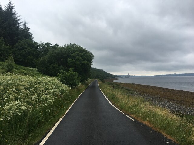
Corriebeg Wood is a picturesque woodland located in Argyllshire, Scotland. Covering a vast area, this forest is a natural treasure offering breathtaking views and a haven for a diverse range of flora and fauna.

Nestled in the heart of the Argyll Forest Park, Corriebeg Wood is known for its untouched beauty and tranquil atmosphere. The wood features a mix of native tree species, including Scots pine, oak, birch, and rowan, creating a rich tapestry of colors throughout the seasons. The dense canopy provides a sanctuary for various bird species, such as woodpeckers, owls, and thrushes, making it a paradise for birdwatchers.

Visitors to Corriebeg Wood can explore its extensive network of well-maintained trails, offering opportunities for leisurely walks, hiking, and nature photography. The paths wind through the woodland, leading to hidden gems like cascading waterfalls, babbling brooks, and ancient ruins. The forest also boasts a diverse range of wildlife, including red squirrels, deer, and foxes, adding to the enchanting experience.

For those seeking solitude and a connection with nature, Corriebeg Wood offers several picnic spots and secluded areas where visitors can relax and immerse themselves in the forest's peaceful ambiance. The wood is also a popular destination for nature education programs, enabling people of all ages to learn about the importance of conservation and the delicate balance of ecosystems.

Overall, Corriebeg Wood in Argyllshire is a captivating woodland that showcases the beauty of Scotland's natural landscapes. With its stunning scenery, abundant wildlife, and peaceful surroundings, it is a must-visit destination for nature enthusiasts and those looking to experience the tranquility of an ancient forest.

If you have any feedback on the listing, please let us know in the comments section below.

Corriebeg Wood Images

Images are sourced within 2km of 55.901936/-5.0389589 or Grid Reference NS1071. Thanks to Geograph Open Source API. All images are credited.

Gatehouse and gated entrance to Knockdow House
Old milepost This milepost is on the north side of the road set into the wall surrounding Knockdow.   Travelling north from Toward Quay the road has done a left turn and then it's downhill to Port Lamont on Loch Striven.
Old milepost
This milepost is on the north side of the road set into the wall surrounding Knockdow. Travelling north from Toward Quay the road has done a left turn and then it's downhill to Port Lamont on Loch Striven.
Old milestone Looking up the road on the way back to Toward and Dunoon, this plate is set well in itsown piece of wall.
Old milestone
Looking up the road on the way back to Toward and Dunoon, this plate is set well in itsown piece of wall.
Old milestone This stone was spotted east of the metal milepost, before the woods and the road taking a sharp right-hand bend.   On the pre 1890 OS 6" there is an MS marked in this area.  The wall surrounds the Knockdow Estate.   An inscribed 10 has either eroded away or this set of stones had the numbers painted on, but most probably inscribed.   Within less than ½ mile this road reaches Port Lamont, perhaps an important landing place for vessels with visitors to Knockdow sailing from Bute.
Old milestone
This stone was spotted east of the metal milepost, before the woods and the road taking a sharp right-hand bend. On the pre 1890 OS 6" there is an MS marked in this area. The wall surrounds the Knockdow Estate. An inscribed 10 has either eroded away or this set of stones had the numbers painted on, but most probably inscribed. Within less than ½ mile this road reaches Port Lamont, perhaps an important landing place for vessels with visitors to Knockdow sailing from Bute.
Old milestone The road rises from Port Lamont along the edge of the Knockdow Estate.   The wall may have been built or rebuilt round the stone after it had been set up in the late 19C.
Old milestone
The road rises from Port Lamont along the edge of the Knockdow Estate. The wall may have been built or rebuilt round the stone after it had been set up in the late 19C.
Loch Striven OFD Viewed across Loch Striven from the west shore near Strone Point. Some of the underground fuel storage tanks can be seen on the hill behind the jetty. The depot is managed by OPA, a statutory public corporation, sponsored by the Secretary of State for Defence, formed in 1986 by virtue of the Oil and Pipelines Act 1985. They manage, operate and maintain 6 Naval Oil Fuel Depots and a Petroleum Storage Depot on behalf of the Ministry of Defence. The Loch Striven OFD site operates as a diesel and aviation fuel storage depot for the Royal Navy and NATO vessels. Loch Striven OFD was built in the 1960s and is located on the south east shore of the loch. 

Due to the volume of fuel stored at the site, OFD Loch Striven is an ‘upper tier’ site under the Control of Major Accident Hazards (COMAH).

Further reading: <span class="nowrap"><a title="https://www.gov.uk/government/organisations/oil-and-pipelines-agency/about" rel="nofollow ugc noopener" href="https://www.gov.uk/government/organisations/oil-and-pipelines-agency/about">Link</a><img style="margin-left:2px;" alt="External link" title="External link - shift click to open in new window" src="https://s1.geograph.org.uk/img/external.png" width="10" height="10"/></span> .

The fishing boat is the Leith registered My lads LH223.
Loch Striven OFD
Viewed across Loch Striven from the west shore near Strone Point. Some of the underground fuel storage tanks can be seen on the hill behind the jetty. The depot is managed by OPA, a statutory public corporation, sponsored by the Secretary of State for Defence, formed in 1986 by virtue of the Oil and Pipelines Act 1985. They manage, operate and maintain 6 Naval Oil Fuel Depots and a Petroleum Storage Depot on behalf of the Ministry of Defence. The Loch Striven OFD site operates as a diesel and aviation fuel storage depot for the Royal Navy and NATO vessels. Loch Striven OFD was built in the 1960s and is located on the south east shore of the loch. Due to the volume of fuel stored at the site, OFD Loch Striven is an ‘upper tier’ site under the Control of Major Accident Hazards (COMAH). Further reading: LinkExternal link . The fishing boat is the Leith registered My lads LH223.
Emergency rendezvous point
Road past Loch Striven Oil Fuel Depot
Road along the shore of Loch Striven
Old milepost Proceeding northwards up Loch Striven, just beyond the MOD jetty, is this milepost in the ditch.   Vegetation was cleared away to show the full length of the post.
Old milepost
Proceeding northwards up Loch Striven, just beyond the MOD jetty, is this milepost in the ditch. Vegetation was cleared away to show the full length of the post.
Old milepost Looking southwards towards Port Lamont, the narrowness of this lane where the 11 Mile post is can be appreciated.  Yet it continues for another 3  or 4 miles up Loch Striven.
Old milepost
Looking southwards towards Port Lamont, the narrowness of this lane where the 11 Mile post is can be appreciated. Yet it continues for another 3 or 4 miles up Loch Striven.
Achafour Farm
Achafour Farm
Knockdow Estate
Knockdow Estate
Road over Ardyne Burn bridge The road down to Loch Striven
Road over Ardyne Burn bridge
The road down to Loch Striven
Loch Striven, Port Lamont road junction
Loch Striven, re-fuelling base Cost a few bob to fill his tank.
Loch Striven, re-fuelling base
Cost a few bob to fill his tank.
Road up Loch Striven
Loch Striven, the old school house
Show me another place!

Corriebeg Wood is located at Grid Ref: NS1071 (Lat: 55.901936, Lng: -5.0389589)

Unitary Authority: Argyll and Bute

Police Authority: Argyll and West Dunbartonshire

What 3 Words

///flukes.brains.pixel. Near Port Bannatyne, Argyll & Bute

Related Wikis

Loch Striven

Loch Striven (Scottish Gaelic: Loch Sroigheann) is a sea loch extending off the Firth of Clyde, and forms part of the Cowal peninsula coast, in Argyll...

Inverchaolain Church

Inverchaolain Church is a former Church of Scotland church building in Inverchaolain, Argyll and Bute, Scotland. Located on the eastern shores of Loch...
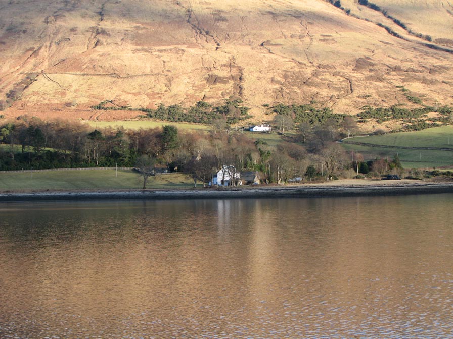
Inverchaolain

Inverchaolain is a hamlet on the Cowal peninsula, Argyll and Bute, Scotland. It lies on the east shore of Loch Striven, to the south of Glenstriven and...
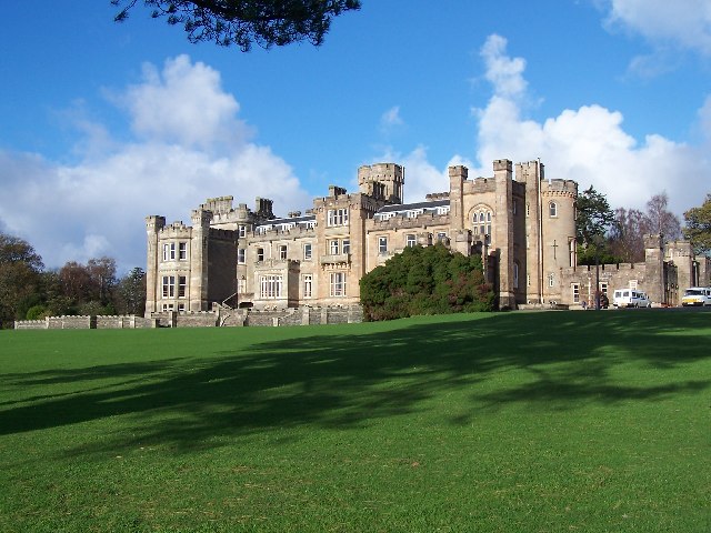
Castle Toward

Castle Toward (Scottish Gaelic: Caisteal an Toll Àird) is a nineteenth-century country house in Argyll and Bute, Scotland. Built in 1820 by Glasgow merchant...

Have you been to Corriebeg Wood?

Leave your review of Corriebeg Wood below (or comments, questions and feedback).