Calshot

Settlement in Hampshire New Forest

England

Calshot

Bourne Gap red buoy
Bourne Gap red buoy Credit: Roger Cornfoot

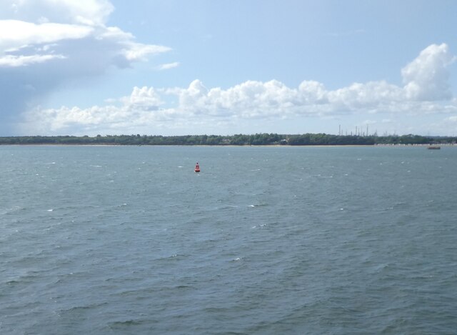
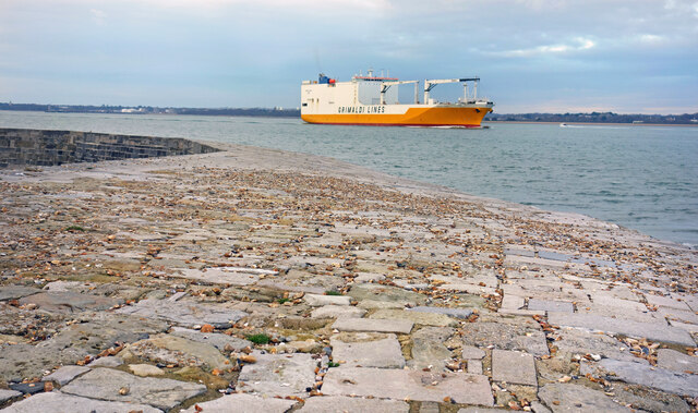
Calshot is a small village located in the county of Hampshire, England. Situated on the southeastern edge of the New Forest National Park, it lies at the tip of a narrow peninsula surrounded by the Solent, a strait separating the Isle of Wight from the mainland.

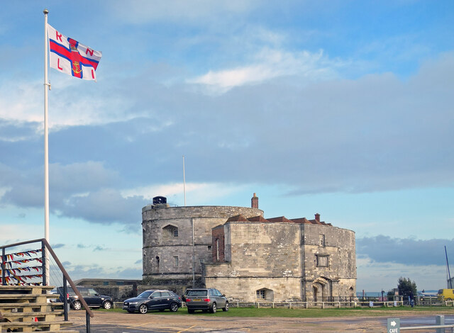
Historically, Calshot has been associated with maritime activities due to its strategic coastal location. In the early 16th century, Henry VIII constructed Calshot Castle to protect the region from potential invaders. The castle, now a scheduled ancient monument, offers visitors a glimpse into its rich history. Additionally, the village was a prominent hub for aviation during the 20th century, with the Royal Air Force establishing a seaplane station and later an airbase.

Today, Calshot remains a popular destination for outdoor enthusiasts and nature lovers. Its coastal location makes it an ideal spot for various water sports such as sailing, windsurfing, and kitesurfing. The Calshot Activities Centre offers a range of activities, including indoor climbing, skiing, and snowboarding, making it a year-round attraction.

Nature enthusiasts can explore the beautiful Calshot Marshes, a designated Site of Special Scientific Interest, known for its diverse bird population and unique wetland habitats. The area is a haven for birdwatching and offers picturesque views of the surrounding landscape.

With its rich history, stunning natural surroundings, and abundance of recreational opportunities, Calshot continues to charm both locals and visitors alike.

If you have any feedback on the listing, please let us know in the comments section below.

Calshot Images

Images are sourced within 2km of 50.81128/-1.321088 or Grid Reference SU4701. Thanks to Geograph Open Source API. All images are credited.

Bourne Gap red buoy
Bourne Gap red buoy
Flag and Castle, Calshot Built in Tudor times to defend the port of Southampton, Calshot Castle now shares the end of Calshot Point with a lifeboat station and coastguard lookout, together with more recent former military buildings.
Flag and Castle, Calshot
Built in Tudor times to defend the port of Southampton, Calshot Castle now shares the end of Calshot Point with a lifeboat station and coastguard lookout, together with more recent former military buildings.
Ship passing Calshot Castle Taken from the stonework around the outer wall of the castle. The entrance to Southampton Docks is fairly narrow and large vessels come quite near the coast just here.
Ship passing Calshot Castle
Taken from the stonework around the outer wall of the castle. The entrance to Southampton Docks is fairly narrow and large vessels come quite near the coast just here.
Old Seaplane Hangar, Calshot An enormous building which once housed seaplanes is now an activity centre with cycling, skiing, climbing etc.
Old Seaplane Hangar, Calshot
An enormous building which once housed seaplanes is now an activity centre with cycling, skiing, climbing etc.
Lawrence House, Calshot Bleak former military housing in an equally bleak location.
Lawrence House, Calshot
Bleak former military housing in an equally bleak location.
The Beach Has Grown From the grid reference this is the same bucket on a stick marker as seen in <a href="https://www.geograph.org.uk/photo/206692">SU4801 : Groynes on Calshot beach</a> showing how the beach has risen in the intervening years. These shingle beaches are ever changing. Next bit of rough weather and it will be different again.
The Beach Has Grown
From the grid reference this is the same bucket on a stick marker as seen in SU4801 : Groynes on Calshot beach showing how the beach has risen in the intervening years. These shingle beaches are ever changing. Next bit of rough weather and it will be different again.
Unsettled Sky, Jack Maynard Road Jack Maynard Road goes along behind the beach huts out to Calshot Castle.
All that Google wants to tell me is that Jack Maynard is another one of many present day media celebrities. 
I'm not convinced this road is named after him though.
Unsettled Sky, Jack Maynard Road
Jack Maynard Road goes along behind the beach huts out to Calshot Castle. All that Google wants to tell me is that Jack Maynard is another one of many present day media celebrities. I'm not convinced this road is named after him though.
Beach Huts, Calshot A long row of traditional wooden huts overlook the shingly beach on the way to Calshot Castle.
Beach Huts, Calshot
A long row of traditional wooden huts overlook the shingly beach on the way to Calshot Castle.
The Hangar @ Calshot The trading name of the Calshot Activities Centre, which is housed in "The largest hangar built in Britain for use by fixed-wing aircraft during World War 1."
"It forms part of the most outstanding group of early aircraft structures of this type in the British Isles." 
Quotes from Historic England listing <span class="nowrap"><a title="https://historicengland.org.uk/listing/the-list/list-entry/1095046?section=official-list-entry" rel="nofollow ugc noopener" href="https://historicengland.org.uk/listing/the-list/list-entry/1095046?section=official-list-entry">Link</a><img style="margin-left:2px;" alt="External link" title="External link - shift click to open in new window" src="https://s1.geograph.org.uk/img/external.png" width="10" height="10"/></span>.
The Hangar @ Calshot
The trading name of the Calshot Activities Centre, which is housed in "The largest hangar built in Britain for use by fixed-wing aircraft during World War 1." "It forms part of the most outstanding group of early aircraft structures of this type in the British Isles." Quotes from Historic England listing LinkExternal link.
View towards Calshot
Calshot Spit buoy, Solent
Mural A mural on the aircraft hangar door at Calshot.
Mural
A mural on the aircraft hangar door at Calshot.
Coastguard Lookout Observation and communication platform, Calshot Spit
Coastguard Lookout
Observation and communication platform, Calshot Spit
Calshot Castle
Calshot Castle
Calshot Beach Looking towards Hill Head
Calshot Beach
Looking towards Hill Head
The Supermarine S.6B Depicted on the end wall of Houston House.
Note;- Patience required when out with a photographer!
The Supermarine S.6B
Depicted on the end wall of Houston House. Note;- Patience required when out with a photographer!
Calshot Castle and tower
In the Channel Isle of Wight ferry heading in the channel between the Hook Navigation Buoy and Calshot
In the Channel
Isle of Wight ferry heading in the channel between the Hook Navigation Buoy and Calshot
Show me another place!

Calshot is located at Grid Ref: SU4701 (Lat: 50.81128, Lng: -1.321088)

Administrative County: Hampshire

District: New Forest

Police Authority: Hampshire

What 3 Words

///unlimited.foods.overt. Near Hamble-le-Rice, Hampshire

Related Wikis

Calshot

Calshot is a coastal village in Hampshire, England, at the west corner of Southampton Water where it joins the Solent. == History == In 1539, Henry VIII...

Luttrell's Tower

Luttrell's Tower is a three-storey stuccoed yellow brick folly south of Southampton, Hampshire, England, near the village of Calshot. It has a six-storey...

Fawley Power Station

Fawley Power Station was an oil-fired power station located on the western side of Southampton Water, between the villages of Fawley and Calshot in Hampshire...

Calshot Marshes

Calshot Marshes is a 51.1-hectare (126-acre) Local Nature Reserve near Calshot, at the junction of The Solent and Southampton Water in Hampshire. It is...

Nearby Amenities

Located within 500m of 50.81128,-1.321088
Calshot
Place: village
Wikidata: Q5023961
Lat/Long: 50.8116628/-1.3263777
Barrier: stile
Lat/Long: 50.8134927/-1.324966
Bus Stop
Calshot Close
Bus: yes
Naptan AtcoCode: 1900HA080485
Naptan Bearing: SE
Naptan CommonName: Calshot Old Stores
Naptan Crossing: Opp Tristan Close
Naptan NaptanCode: hamdgmtj
Naptan Street: B3053
Naptan Verified: no
Public Transport: platform
Source: naptan_import
Lat/Long: 50.8115763/-1.3262822
Bus Stop
Calshot Close
Bus: yes
Naptan AtcoCode: 1900HA080486
Naptan Bearing: NW
Naptan CommonName: Calshot Old Stores
Naptan Crossing: Calshot Close
Naptan NaptanCode: hamdgmwg
Naptan Street: B3053
Naptan Verified: no
Public Transport: platform
Source: naptan_import
Lat/Long: 50.8111729/-1.3253538
Bus Stop
Calshot Beach
Bus: yes
Naptan AtcoCode: 1900HA080487
Naptan Bearing: E
Naptan CommonName: Calshot Beach
Naptan Crossing: At Car Park
Naptan NaptanCode: hamdgtjt
Naptan Street: B3053
Naptan Verified: no
Public Transport: platform
Source: naptan_import
Lat/Long: 50.8096756/-1.3196829
Cafe
Bluebird Cafe
Addr City: Southampton
Addr Country: GB
Addr Housename: Calshot Beach West
Addr Postcode: SO45 1BS
Addr Village: Calshot
Fhrs Id: 664160
Lat/Long: 50.808789/-1.3196042
Toilets
Calshot Beach Car Park
Access: yes
Fee: no
Toilets Disposal: flush
Wheelchair: yes
Lat/Long: 50.8092547/-1.3190957
Post Box
Operator: Royal Mail
Operator Wikidata: Q638098
Post Box Type: pillar
Ref: SO45 165
Royal Cypher: GR
Royal Cypher Wikidata: Q33102273
Lat/Long: 50.8116475/-1.3265397
Recycling
Opening Hours: 24/7
Recycling Cans: yes
Recycling Clothes: yes
Recycling Glass: yes
Recycling Type: container
Wheelchair: limited
Lat/Long: 50.8094987/-1.3186516
Barrier: stile
Foot: yes
Lat/Long: 50.8118634/-1.3273408
Public Building
St George's Hall
Lat/Long: 50.8110362/-1.3254938
RMS Car Repairs
Shop: car_repair
Lat/Long: 50.811789/-1.3277616
Beach Use Rules
Information: rules
Tourism: information
Lat/Long: 50.8088645/-1.3194725
Addr Housenumber: 1
Lat/Long: 50.809277/-1.3183987
Addr Housenumber: 1
Lat/Long: 50.8096242/-1.3212073
Addr Housenumber: 22
Lat/Long: 50.8088153/-1.319372
Addr Housenumber: 23
Lat/Long: 50.8087976/-1.3194664
Addr Housenumber: 30
Lat/Long: 50.8085935/-1.3198188
Addr Housenumber: 4
Lat/Long: 50.8094579/-1.3211925
Addr Housenumber: 40
Lat/Long: 50.8082436/-1.3204035
Addr Housenumber: 50
Lat/Long: 50.8079396/-1.3209182
Addr Housenumber: 64
Lat/Long: 50.8075656/-1.321594
Turning Circle
Lat/Long: 50.8116455/-1.3251852
Addr Country: GB
Addr Housename: Valkyrie
Addr Housenumber: 9
Addr Street: Calshot Road
Lat/Long: 50.810297/-1.3219478
Addr Country: GB
Addr Housenumber: 1
Addr Street: Calshot Court
Lat/Long: 50.8120276/-1.3268506
Addr Country: GB
Addr Housenumber: 4
Addr Street: Calshot Court
Lat/Long: 50.8119079/-1.3266863
Addr Country: GB
Addr Housenumber: 42
Addr Street: Calshot Close
Lat/Long: 50.8116424/-1.3258978
Addr Country: GB
Addr Housenumber: 7
Addr Street: Calshot Close
Lat/Long: 50.8108765/-1.3232633
Addr Country: GB
Addr Housenumber: 71
Addr Street: Calshot Close
Lat/Long: 50.8114673/-1.3253595
Addr Country: GB
Addr Housenumber: 74
Addr Street: Calshot Close
Lat/Long: 50.8113857/-1.3250925
Addr Country: GB
Addr Housenumber: 75
Addr Street: Calshot Close
Lat/Long: 50.8113407/-1.3248415
Addr Country: GB
Addr Housenumber: 78
Addr Street: Calshot Close
Lat/Long: 50.8112582/-1.3245716
Addr Housenumber: 8
Lat/Long: 50.8103769/-1.3220505
Addr Country: GB
Addr Housenumber: 8
Addr Street: Calshot Close
Lat/Long: 50.810848/-1.3231748
Addr Country: GB
Addr Housenumber: 79
Addr Street: Calshot Close
Lat/Long: 50.8112299/-1.3243497
Addr Country: GB
Addr Housenumber: 82
Addr Street: Calshot Close
Lat/Long: 50.8111464/-1.3240725
Addr Country: GB
Addr Housenumber: 39
Addr Street: Calshot Close
Lat/Long: 50.8117313/-1.3261952
Barrier: stile
Foot: yes
Lat/Long: 50.812885/-1.3252786
Addr Country: GB
Addr Housenumber: 43
Addr Street: Calshot Close
Lat/Long: 50.8117733/-1.3256838
Addr Country: GB
Addr Housenumber: 48
Addr Street: Calshot Close
Lat/Long: 50.8121021/-1.3254236
Addr Country: GB
Addr Housenumber: 49
Addr Street: Calshot Close
Lat/Long: 50.8121177/-1.3248924
Addr Country: GB
Addr Housenumber: 52
Addr Street: Calshot Close
Lat/Long: 50.8120326/-1.324627
Addr Country: GB
Addr Housenumber: 53
Addr Street: Calshot Close
Lat/Long: 50.8119988/-1.3244322
Addr Country: GB
Addr Housenumber: 55
Addr Street: Calshot Close
Lat/Long: 50.8119226/-1.3242054
Addr Country: GB
Addr Housenumber: 58
Addr Street: Calshot Close
Lat/Long: 50.8118147/-1.3238724
Addr Country: GB
Addr Housenumber: 59
Addr Street: Calshot Close
Lat/Long: 50.8115227/-1.324082
Addr Country: GB
Addr Housenumber: 62
Addr Street: Calshot Close
Lat/Long: 50.8115934/-1.3244878
Addr Country: GB
Addr Housenumber: 66
Addr Street: Calshot Close
Lat/Long: 50.811814/-1.3249249
Addr Country: GB
Addr Housenumber: 67
Addr Street: Calshot Close
Lat/Long: 50.8118372/-1.3252021
Addr Country: GB
Addr Housenumber: 70
Addr Street: Calshot Close
Lat/Long: 50.811692/-1.3253229
Addr Country: GB
Addr Housenumber: 1
Addr Street: Tristan Close
Lat/Long: 50.811334/-1.3268202
Addr Country: GB
Addr Housenumber: 10
Addr Street: Tristan Close
Lat/Long: 50.8112687/-1.3274838
Addr Country: GB
Addr Housenumber: 11
Addr Street: Tristan Close
Lat/Long: 50.8112071/-1.3275618
Addr Country: GB
Addr Housenumber: 14
Addr Street: Tristan Close
Lat/Long: 50.8110759/-1.3277158
Addr Country: GB
Addr Housenumber: 15
Addr Street: Tristan Close
Lat/Long: 50.8109146/-1.3279415
Addr Country: GB
Addr Housenumber: 18
Addr Street: Tristan Close
Lat/Long: 50.810793/-1.3280981
Addr Country: GB
Addr Housenumber: 2
Addr Street: Tristan Close
Lat/Long: 50.8114027/-1.3269616
Addr Country: GB
Addr Housenumber: 3
Addr Street: Tristan Close
Lat/Long: 50.8115791/-1.3270918
Addr Country: GB
Addr Housenumber: 53
Addr Street: Tristan Close
Lat/Long: 50.8102055/-1.3276791
Addr Country: GB
Addr Housenumber: 57
Addr Street: Tristan Close
Lat/Long: 50.8103567/-1.3274092
Addr Country: GB
Addr Housenumber: 58
Addr Street: Tristan Close
Lat/Long: 50.8104508/-1.3273165
Addr Country: GB
Addr Housenumber: 6
Addr Street: Tristan Close
Lat/Long: 50.8114456/-1.3272518
Addr Country: GB
Addr Housenumber: 61
Addr Street: Tristan Close
Lat/Long: 50.8105736/-1.3271149
Addr Country: GB
Addr Housenumber: 62
Addr Street: Tristan Close
Lat/Long: 50.8106268/-1.3269605
Addr Country: GB
Addr Housenumber: 64
Addr Street: Tristan Close
Lat/Long: 50.8107257/-1.3268835
Addr Country: GB
Addr Housenumber: 65
Addr Street: Tristan Close
Lat/Long: 50.8108892/-1.327284
Addr Country: GB
Addr Housenumber: 67
Addr Street: Tristan Close
Lat/Long: 50.8109537/-1.3274186
Addr Country: GB
Addr Housenumber: 7
Addr Street: Tristan Close
Lat/Long: 50.8113924/-1.327337
Barrier: block
Bicycle: no
Foot: yes
Lat/Long: 50.8097788/-1.3191763
Barrier: block
Foot: yes
Lat/Long: 50.809592/-1.3188174
Direction: SE
Generator Method: photovoltaic
Generator Output Electricity: yes
Generator Solar Modules: 16
Generator Source: solar
Generator Type: solar_photovoltaic_panel
Location: roof
Power: generator
Lat/Long: 50.8087599/-1.3205229
Direction: 145
Generator Method: photovoltaic
Generator Output Electricity: yes
Generator Solar Modules: 18
Generator Source: solar
Generator Type: solar_photovoltaic_panel
Location: roof
Power: generator
Lat/Long: 50.8088831/-1.3199878
Cadland Estate -Private Beach
Board Type: notice
Direction: 50
Information: board
Operator: Cadland Estates
Tourism: information
Lat/Long: 50.8092524/-1.3182306
Information: guidepost
Material: wood
Tourism: information
Lat/Long: 50.811884/-1.3272299
Information: guidepost
Material: wood
Tourism: information
Lat/Long: 50.813929/-1.3248442
Man Made: water_tap
Lat/Long: 50.8109763/-1.3151228
The data included in this document is from www.openstreetmap.org. The data is made available under ODbL.

Have you been to Calshot?

Leave your review of Calshot below (or comments, questions and feedback).