Coed Parciau

Wood, Forest in Monmouthshire

Wales

Coed Parciau

Layby alongside the A472 in Torfaen Ahead for Pontypool. Behind the camera for Hafodyrynys.
Layby alongside the A472 in Torfaen Credit: Jaggery

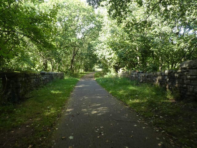
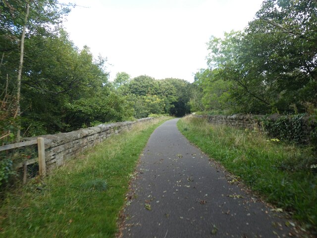
Coed Parciau is a woodland area located in Monmouthshire, Wales. This forest is known for its diverse range of plant and animal species, making it a popular destination for nature enthusiasts and hikers. The woodland is spread across a vast area, providing plenty of opportunities for exploration and outdoor activities.

Visitors to Coed Parciau can expect to see a variety of trees, including oak, beech, and birch, as well as an array of wildlife such as deer, squirrels, and birds. The forest is also home to a number of walking and cycling trails, allowing visitors to immerse themselves in the natural beauty of the area.

In addition to its natural beauty, Coed Parciau also has historical significance, with evidence of ancient settlements and structures dating back to prehistoric times. The forest is managed by the Forestry Commission, ensuring that it remains a protected area for future generations to enjoy.

Overall, Coed Parciau is a tranquil and scenic woodland that offers a peaceful escape from the hustle and bustle of everyday life. Whether you're looking to reconnect with nature or simply enjoy a leisurely walk in the woods, this forest has something to offer for everyone.

If you have any feedback on the listing, please let us know in the comments section below.

Coed Parciau Images

Images are sourced within 2km of 51.700315/-3.0732985 or Grid Reference SO2500. Thanks to Geograph Open Source API. All images are credited.

Layby alongside the A472 in Torfaen Ahead for Pontypool. Behind the camera for Hafodyrynys.
Layby alongside the A472 in Torfaen
Ahead for Pontypool. Behind the camera for Hafodyrynys.
Pantygasseg - Please drive carefully The sign also shows Welcome and the Welsh Croeso.
Pantygasseg - Please drive carefully
The sign also shows Welcome and the Welsh Croeso.
Bush Terrace, Pantygasseg, Torfaen Ahead for Hafodyrynys. Behind the camera for Pontypool.
Bush Terrace, Pantygasseg, Torfaen
Ahead for Hafodyrynys. Behind the camera for Pontypool.
Side road in Pantygasseg, Torfaen Viewed from Bush Terrace.
Side road in Pantygasseg, Torfaen
Viewed from Bush Terrace.
5-bar gate, Pantygasseg, Torfaen On the right here. <a title="https://www.geograph.org.uk/photo/7488539" href="https://www.geograph.org.uk/photo/7488539">Link</a>
5-bar gate, Pantygasseg, Torfaen
On the right here. Link
Cycle track on former railway line, Pontnewynydd
NCN492 on former railway track, Pontnewynydd The National Cycle Network is a network of cycle routes. It was created by the charity Sustrans <span class="nowrap"><a title="http://www.sustrans.org.uk/what-we-do/national-cycle-network" rel="nofollow ugc noopener" href="http://www.sustrans.org.uk/what-we-do/national-cycle-network">Link</a><img style="margin-left:2px;" alt="External link" title="External link - shift click to open in new window" src="https://s1.geograph.org.uk/img/external.png" width="10" height="10"/></span>  (Sustainable Transport), aided by a National Lottery grant.

Many routes aim to minimise contact with motor traffic, though 70% of them are on roads. In some cases the NCN uses pedestrian routes, disused railways, minor roads, canal towpaths, or traffic-calmed routes in towns and cities.
NCN492 on former railway track, Pontnewynydd
The National Cycle Network is a network of cycle routes. It was created by the charity Sustrans LinkExternal link (Sustainable Transport), aided by a National Lottery grant. Many routes aim to minimise contact with motor traffic, though 70% of them are on roads. In some cases the NCN uses pedestrian routes, disused railways, minor roads, canal towpaths, or traffic-calmed routes in towns and cities.
NCN492 on former railway track south of Cwm Ffrwd-oer The National Cycle Network is a network of cycle routes. It was created by the charity Sustrans <span class="nowrap"><a title="http://www.sustrans.org.uk/what-we-do/national-cycle-network" rel="nofollow ugc noopener" href="http://www.sustrans.org.uk/what-we-do/national-cycle-network">Link</a><img style="margin-left:2px;" alt="External link" title="External link - shift click to open in new window" src="https://s1.geograph.org.uk/img/external.png" width="10" height="10"/></span>  (Sustainable Transport), aided by a National Lottery grant.

Many routes aim to minimise contact with motor traffic, though 70% of them are on roads. In some cases the NCN uses pedestrian routes, disused railways, minor roads, canal towpaths, or traffic-calmed routes in towns and cities.
NCN492 on former railway track south of Cwm Ffrwd-oer
The National Cycle Network is a network of cycle routes. It was created by the charity Sustrans LinkExternal link (Sustainable Transport), aided by a National Lottery grant. Many routes aim to minimise contact with motor traffic, though 70% of them are on roads. In some cases the NCN uses pedestrian routes, disused railways, minor roads, canal towpaths, or traffic-calmed routes in towns and cities.
Access to NCN492 near Cwm Ffrwd-oer The metal barrier on the right is designed to prevent motorcycles from accessing the cycle track.  They also hamper cyclists with unusual bicycles.  NCN492 runs along a former railway line
Access to NCN492 near Cwm Ffrwd-oer
The metal barrier on the right is designed to prevent motorcycles from accessing the cycle track. They also hamper cyclists with unusual bicycles. NCN492 runs along a former railway line
NCN492 on old railway line On each side there are what appear to be platforms; no station is marked on the old maps, but a brickworks was close to the line
NCN492 on old railway line
On each side there are what appear to be platforms; no station is marked on the old maps, but a brickworks was close to the line
Farm bridge over NCN492 (old railway track) The National Cycle Network is a network of cycle routes. It was created by the charity Sustrans <span class="nowrap"><a title="http://www.sustrans.org.uk/what-we-do/national-cycle-network" rel="nofollow ugc noopener" href="http://www.sustrans.org.uk/what-we-do/national-cycle-network">Link</a><img style="margin-left:2px;" alt="External link" title="External link - shift click to open in new window" src="https://s1.geograph.org.uk/img/external.png" width="10" height="10"/></span>  (Sustainable Transport), aided by a National Lottery grant.

Many routes aim to minimise contact with motor traffic, though 70% of them are on roads. In some cases the NCN uses pedestrian routes, disused railways, minor roads, canal towpaths, or traffic-calmed routes in towns and cities.
Farm bridge over NCN492 (old railway track)
The National Cycle Network is a network of cycle routes. It was created by the charity Sustrans LinkExternal link (Sustainable Transport), aided by a National Lottery grant. Many routes aim to minimise contact with motor traffic, though 70% of them are on roads. In some cases the NCN uses pedestrian routes, disused railways, minor roads, canal towpaths, or traffic-calmed routes in towns and cities.
Cycle track on Cwm Ffrwd-Oer viaduct The National Cycle Network is a network of cycle routes. It was created by the charity Sustrans <span class="nowrap"><a title="http://www.sustrans.org.uk/what-we-do/national-cycle-network" rel="nofollow ugc noopener" href="http://www.sustrans.org.uk/what-we-do/national-cycle-network">Link</a><img style="margin-left:2px;" alt="External link" title="External link - shift click to open in new window" src="https://s1.geograph.org.uk/img/external.png" width="10" height="10"/></span>  (Sustainable Transport), aided by a National Lottery grant.

Many routes aim to minimise contact with motor traffic, though 70% of them are on roads. In some cases the NCN uses pedestrian routes, disused railways, minor roads, canal towpaths, or traffic-calmed routes in towns and cities.
Cycle track on Cwm Ffrwd-Oer viaduct
The National Cycle Network is a network of cycle routes. It was created by the charity Sustrans LinkExternal link (Sustainable Transport), aided by a National Lottery grant. Many routes aim to minimise contact with motor traffic, though 70% of them are on roads. In some cases the NCN uses pedestrian routes, disused railways, minor roads, canal towpaths, or traffic-calmed routes in towns and cities.
Cycle track in railway cutting north of Cwm Ffrwd-Oer The National Cycle Network is a network of cycle routes. It was created by the charity Sustrans <span class="nowrap"><a title="http://www.sustrans.org.uk/what-we-do/national-cycle-network" rel="nofollow ugc noopener" href="http://www.sustrans.org.uk/what-we-do/national-cycle-network">Link</a><img style="margin-left:2px;" alt="External link" title="External link - shift click to open in new window" src="https://s1.geograph.org.uk/img/external.png" width="10" height="10"/></span>  (Sustainable Transport), aided by a National Lottery grant.

Many routes aim to minimise contact with motor traffic, though 70% of them are on roads. In some cases the NCN uses pedestrian routes, disused railways, minor roads, canal towpaths, or traffic-calmed routes in towns and cities.
Cycle track in railway cutting north of Cwm Ffrwd-Oer
The National Cycle Network is a network of cycle routes. It was created by the charity Sustrans LinkExternal link (Sustainable Transport), aided by a National Lottery grant. Many routes aim to minimise contact with motor traffic, though 70% of them are on roads. In some cases the NCN uses pedestrian routes, disused railways, minor roads, canal towpaths, or traffic-calmed routes in towns and cities.
Pentre-Piod Road bridge over NCN492 (former railway) The National Cycle Network is a network of cycle routes. It was created by the charity Sustrans <span class="nowrap"><a title="http://www.sustrans.org.uk/what-we-do/national-cycle-network" rel="nofollow ugc noopener" href="http://www.sustrans.org.uk/what-we-do/national-cycle-network">Link</a><img style="margin-left:2px;" alt="External link" title="External link - shift click to open in new window" src="https://s1.geograph.org.uk/img/external.png" width="10" height="10"/></span>  (Sustainable Transport), aided by a National Lottery grant.

Many routes aim to minimise contact with motor traffic, though 70% of them are on roads. In some cases the NCN uses pedestrian routes, disused railways, minor roads, canal towpaths, or traffic-calmed routes in towns and cities.
Pentre-Piod Road bridge over NCN492 (former railway)
The National Cycle Network is a network of cycle routes. It was created by the charity Sustrans LinkExternal link (Sustainable Transport), aided by a National Lottery grant. Many routes aim to minimise contact with motor traffic, though 70% of them are on roads. In some cases the NCN uses pedestrian routes, disused railways, minor roads, canal towpaths, or traffic-calmed routes in towns and cities.
Football pitch near Cwm Ffrwd-Oer
The woodland of Graig Ddu
Plasycoed Road bridge over NCN492 The National Cycle Network is a network of cycle routes. It was created by the charity Sustrans <span class="nowrap"><a title="http://www.sustrans.org.uk/what-we-do/national-cycle-network" rel="nofollow ugc noopener" href="http://www.sustrans.org.uk/what-we-do/national-cycle-network">Link</a><img style="margin-left:2px;" alt="External link" title="External link - shift click to open in new window" src="https://s1.geograph.org.uk/img/external.png" width="10" height="10"/></span>  (Sustainable Transport), aided by a National Lottery grant.

Many routes aim to minimise contact with motor traffic, though 70% of them are on roads. In some cases the NCN uses pedestrian routes, disused railways, minor roads, canal towpaths, or traffic-calmed routes in towns and cities.
Plasycoed Road bridge over NCN492
The National Cycle Network is a network of cycle routes. It was created by the charity Sustrans LinkExternal link (Sustainable Transport), aided by a National Lottery grant. Many routes aim to minimise contact with motor traffic, though 70% of them are on roads. In some cases the NCN uses pedestrian routes, disused railways, minor roads, canal towpaths, or traffic-calmed routes in towns and cities.
NCN492 south of Pontnewynydd The cycle route follows the old railway through a shallow cutting
NCN492 south of Pontnewynydd
The cycle route follows the old railway through a shallow cutting
Show me another place!

Coed Parciau is located at Grid Ref: SO2500 (Lat: 51.700315, Lng: -3.0732985)

Unitary Authority: Torfaen

Police Authority: Gwent

What 3 Words

///being.smooth.yoga. Near Pontypool, Torfaen

Related Wikis

Cwmffrwdoer Halt railway station

Cwmffrwdoer Halt railway station served the suburb of Pontnewynydd, in the historical county of Monmouthshire, Wales, from 1912 to 1941 on the Pontypool...

Torfaen (UK Parliament constituency)

Torfaen is a constituency in Wales represented in the House of Commons of the UK Parliament since 2015 by Nick Thomas-Symonds, a member of the Labour Party...

Torfaen (Senedd constituency)

Torfaen is a constituency of the Senedd. It elects one Member of the Senedd by the first past the post method of election. It is also one of eight constituencies...

Pen Tranch

Pen Tranch is a large village and a community in Torfaen, South East Wales. It lies to the west of Pontypool in the valley leading west to Crumlin. It...

Related Videos

Lidl Rocktrail Hiking Shoes - £19.99

Lidl have their hiking gear back in the middle eye. I test the Lidl Rocktrail hiking shoes to see if they are any good... If you want to ...

Wales.Blue lagoon. #travel #wales #cool#snow

From the parking lot you need to walk 3.5 km uphill and you come to a hot river where you can swim.

Forest walk

me and Boovy went on a walk.

Nearby Amenities

Located within 500m of 51.700315,-3.0732985
PlasyCoed B&B (ex pub)
Tourism: hotel
Lat/Long: 51.7040103/-3.0721616
Power: tower
Lat/Long: 51.6990285/-3.0666876
Power: tower
Lat/Long: 51.7000093/-3.0673045
Power: tower
Lat/Long: 51.7007856/-3.06779
Power: tower
Lat/Long: 51.7015387/-3.0682513
Power: tower
Lat/Long: 51.7025759/-3.0688924
The data included in this document is from www.openstreetmap.org. The data is made available under ODbL.

Have you been to Coed Parciau?

Leave your review of Coed Parciau below (or comments, questions and feedback).