Coed Cefn Maesmawr

Wood, Forest in Montgomeryshire

Wales

Coed Cefn Maesmawr

River Dovey near Derwenlas
River Dovey near Derwenlas Credit: Chris Morgan

Coed Cefn Maesmawr is a picturesque woodland located in Montgomeryshire, a historic county in Wales. Situated in the heart of the country, this woodland offers a tranquil escape for nature enthusiasts and outdoor adventurers alike.

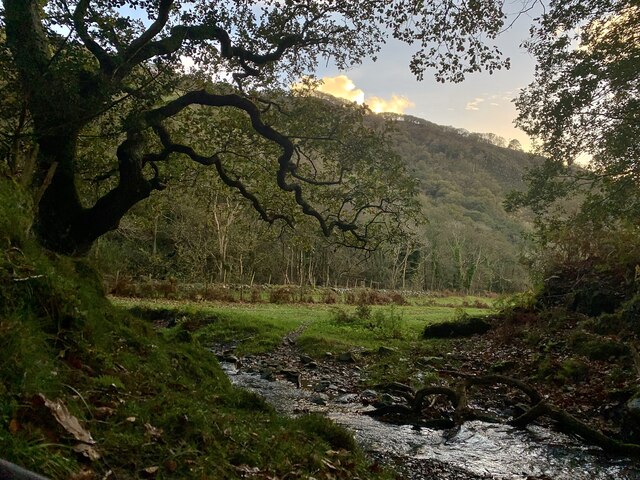
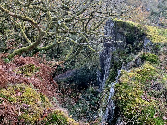
Covering an area of approximately 150 acres, Coed Cefn Maesmawr is characterized by its diverse range of tree species, including oak, beech, birch, and pine. The canopy of these towering trees provides a cool and shady environment, perfect for exploration during the warm summer months. The woodland floor is adorned with an array of vibrant wildflowers, creating a colorful tapestry that attracts a variety of wildlife.

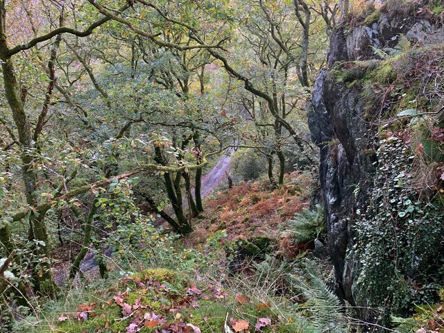
Traversing through the woodland, visitors can find a network of well-maintained footpaths and trails, allowing for leisurely walks and hikes. These paths wind through the trees, offering glimpses of stunning vistas and providing opportunities for birdwatching. Nature enthusiasts may spot a variety of species, including woodpeckers, red kites, and squirrels.

Coed Cefn Maesmawr is also home to a number of historical features, such as ancient earthworks and remnants of old settlements. These archaeological sites provide a glimpse into the area's rich past and offer a unique insight into the lives of those who once inhabited the region.

Overall, Coed Cefn Maesmawr is a haven for nature lovers and history enthusiasts alike. With its diverse range of trees, abundant wildlife, and fascinating historical features, this woodland offers a serene and captivating experience for all who visit.

If you have any feedback on the listing, please let us know in the comments section below.

Coed Cefn Maesmawr Images

Images are sourced within 2km of 52.562219/-3.8807128 or Grid Reference SN7297. Thanks to Geograph Open Source API. All images are credited.

River Dovey near Derwenlas
Gelli-gau, Glaspwll The house of Gelli-gau seen in late afternoon sunlight from the bridleway approaching it.
Gelli-gau, Glaspwll
The house of Gelli-gau seen in late afternoon sunlight from the bridleway approaching it.
Underneath the larches From the bridleway above the Afon Llyfnant, the colour of the autumnal larch woods seems almost to stain the air.
Underneath the larches
From the bridleway above the Afon Llyfnant, the colour of the autumnal larch woods seems almost to stain the air.
Hen dderwen, Cwm Llyfnant A tiny tributary rushes down from the hills to join the Afon Llyfnant, overlooked by a glorious old oak tree.
Hen dderwen, Cwm Llyfnant
A tiny tributary rushes down from the hills to join the Afon Llyfnant, overlooked by a glorious old oak tree.
Clogwyn Cwm Llyfnant A massive rock above the Llyfnant makes for unexpectedly dramatic cliffs in the wooded valley.
Clogwyn Cwm Llyfnant
A massive rock above the Llyfnant makes for unexpectedly dramatic cliffs in the wooded valley.
Coedwig Cwm Llyfnant Looking down towards the largely unused lane through the wooded Cwm Llyfnant from the top of the massive rock above it.
Coedwig Cwm Llyfnant
Looking down towards the largely unused lane through the wooded Cwm Llyfnant from the top of the massive rock above it.
Pompren Llyfnant The footbridge spans not just the lovely Afon Llyfnant, but the counties of Powys (far side) and Ceredigion (near).
Pompren Llyfnant
The footbridge spans not just the lovely Afon Llyfnant, but the counties of Powys (far side) and Ceredigion (near).
Lôn olaf yng Ngheredigion, Glaspwll The Afon Llyfnant is the northernmost border of Ceredigion, so this lane is the last in the county. It was closed to through traffic a decade ago, as it is extremely narrow and the rock face to the right - dripping with ferns and mosses - was considered too risky.
Lôn olaf yng Ngheredigion, Glaspwll
The Afon Llyfnant is the northernmost border of Ceredigion, so this lane is the last in the county. It was closed to through traffic a decade ago, as it is extremely narrow and the rock face to the right - dripping with ferns and mosses - was considered too risky.
Dyffryn Llyfnant Sign at the Glaspwll junction, with the autumn afternoon sun catching the forested peak of Cefn Coch behind. Cwmyrhaiadr farm, down the lane to the left, is now home to the Dyfi Falls pheasant shoot.
Dyffryn Llyfnant
Sign at the Glaspwll junction, with the autumn afternoon sun catching the forested peak of Cefn Coch behind. Cwmyrhaiadr farm, down the lane to the left, is now home to the Dyfi Falls pheasant shoot.
Old milestone by Hen Gapel, Derwenlas This classic old Welsh slate milestone stands in front of Hen Gapel, Derwenlas alongside the A487. The top is damaged and it appears to have two lots of inscriptions both apparently indicating 2 miles to Machynlleth. The milestone isn't marked on any maps I've seen, but does appear to be equidistant between milestones 'Mach 1', which is now in a cut off section of the A487 (if the MS exists), and 'Mach 3' further west, which may have been lost to an RTC, where there is a hole in the hedge. 
For a wider view of this milestone see <a href="https://www.geograph.org.uk/photo/7519195">SN7299 : Derwenlas by the A487, and a milestone</a>

Inscription reads:-
         2 M
MA(CH)
2 M.

Surveyed

Milestone Society National ID: MOT_AYMC15
Old milestone by Hen Gapel, Derwenlas
This classic old Welsh slate milestone stands in front of Hen Gapel, Derwenlas alongside the A487. The top is damaged and it appears to have two lots of inscriptions both apparently indicating 2 miles to Machynlleth. The milestone isn't marked on any maps I've seen, but does appear to be equidistant between milestones 'Mach 1', which is now in a cut off section of the A487 (if the MS exists), and 'Mach 3' further west, which may have been lost to an RTC, where there is a hole in the hedge. For a wider view of this milestone see SN7299 : Derwenlas by the A487, and a milestone Inscription reads:- 2 M MA(CH) 2 M. Surveyed Milestone Society National ID: MOT_AYMC15
Derwenlas by the A487, and a milestone Looking west along the A487 in Derwenlas. On the right there is a slate milestone in front of Hen Gapel <a href="https://www.geograph.org.uk/photo/7519171">SN7299 : Old milestone by Hen Gapel, Derwenlas</a>
Derwenlas by the A487, and a milestone
Looking west along the A487 in Derwenlas. On the right there is a slate milestone in front of Hen Gapel SN7299 : Old milestone by Hen Gapel, Derwenlas
A487 at Bryn Siriol
A487 at Bryn Siriol
A plaque marking the centenary of a death In 2021 it was the centenary of the death of local man Harold Owen Owen in the Abermule train disaster, which is still Britain's worst rail accident. See: <span class="nowrap"><a title="https://en.wikipedia.org/wiki/Abermule_train_collision" rel="nofollow ugc noopener" href="https://en.wikipedia.org/wiki/Abermule_train_collision">Link</a><img style="margin-left:2px;" alt="External link" title="External link - shift click to open in new window" src="https://s1.geograph.org.uk/img/external.png" width="10" height="10"/></span>
A plaque marking the centenary of a death
In 2021 it was the centenary of the death of local man Harold Owen Owen in the Abermule train disaster, which is still Britain's worst rail accident. See: LinkExternal link
The road junction near Glaspwll
An avenue in the trees in Coed Cae'rbobian The name of the wood on the map seems to be an OS typo, as the nearby farm is called Cae'r-bobian.
An avenue in the trees in Coed Cae'rbobian
The name of the wood on the map seems to be an OS typo, as the nearby farm is called Cae'r-bobian.
The road through the trees next to Coed Cae'rbobian The name of the wood on the map seems to be an OS typo, as the nearby farm is called Cae'r-bobian.
The road through the trees next to Coed Cae'rbobian
The name of the wood on the map seems to be an OS typo, as the nearby farm is called Cae'r-bobian.
Luxuriant vegetation on the roadside
Taking the road most travelled The track to the left is a bridleway, but not on today's route plan, which follows the minor road.
Taking the road most travelled
The track to the left is a bridleway, but not on today's route plan, which follows the minor road.
Show me another place!

Coed Cefn Maesmawr is located at Grid Ref: SN7297 (Lat: 52.562219, Lng: -3.8807128)

Unitary Authority: Powys

Police Authority: Dyfed Powys

What 3 Words

///directs.taken.tango. Near Machynlleth, Powys

Related Wikis

Derwenlas

Derwenlas is a hamlet in northern Powys, Wales. It is part of the community of Cadfarch. Part of the historic county of Montgomeryshire (Sir Drefaldwyn...

Morben

Morben is a hamlet in northern Powys, Wales. Part of the historic county of Montgomeryshire (Sir Drefaldwyn) from 1536 to 1974, it lies on the Afon Dyfi...
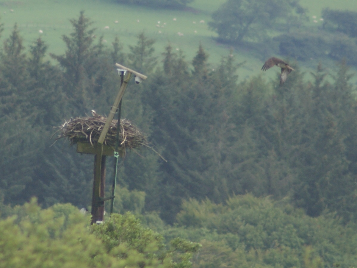
Dyfi Osprey Project

The Dyfi Osprey Project is a conservation project at the Cors Dyfi nature reserve near Derwenlas, in the county of Powys, Wales, under the management of...

Cors Dyfi nature reserve

Cors Dyfi is a nature reserve located near to the village of Derwenlas, in the county of Powys, Wales. Located on land reclaimed from the Estuary on the...

Nearby Amenities

Located within 500m of 52.562219,-3.8807128
The data included in this document is from www.openstreetmap.org. The data is made available under ODbL.

Have you been to Coed Cefn Maesmawr?

Leave your review of Coed Cefn Maesmawr below (or comments, questions and feedback).