Allt Isaf

Wood, Forest in Carmarthenshire

Wales

Allt Isaf

Country road passing through Allt y Graig Country road passing through Allt y Graig in the Cothi valley.
Country road passing through Allt y Graig Credit: Philip Halling

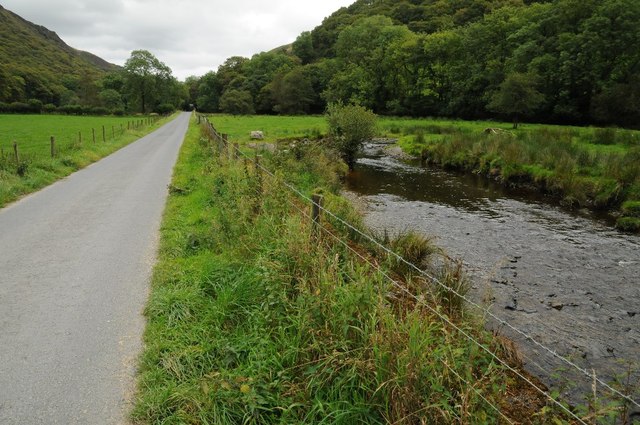
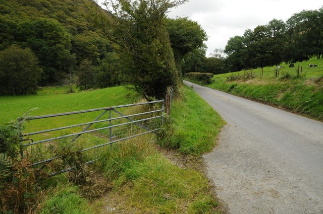
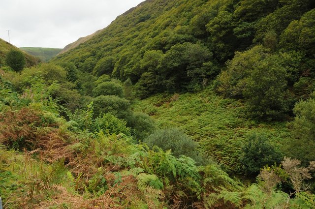
Allt Isaf, located in Carmarthenshire, Wales, is a picturesque wood or forest that stretches across a vast area. The name "Allt Isaf" translates to "lower slope" in English, which accurately describes its geographical features. This woodland is nestled in the foothills of the Brecon Beacons National Park, offering visitors a tranquil and scenic experience.

Allt Isaf boasts a diverse range of tree species, including oak, ash, beech, and conifers, which create a rich and vibrant ecosystem. The forest floor is carpeted with a variety of wildflowers, providing a burst of color during the spring and summer months.

The wood is home to an array of wildlife, with many species finding sanctuary in its peaceful surroundings. Visitors may be lucky enough to spot red kites soaring above, as well as various songbirds, mammals, and insects. Birdwatchers and nature enthusiasts will find Allt Isaf a haven for observing and appreciating the local wildlife.

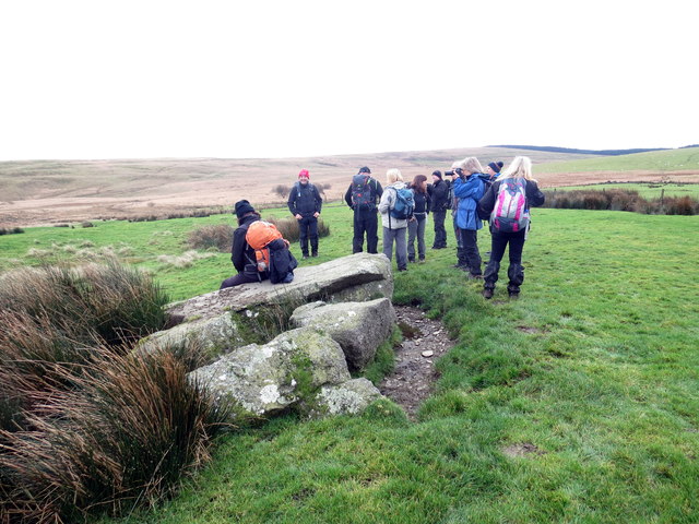
There are several walking trails that wind through the wood, allowing visitors to explore and immerse themselves in its natural beauty. The paths are well-maintained and suitable for all abilities, making it accessible to a wide range of people.

Allt Isaf is a popular destination for nature lovers, hikers, and those seeking a peaceful retreat. Its serene atmosphere and breathtaking scenery make it an ideal location for relaxation, photography, and connecting with nature.

If you have any feedback on the listing, please let us know in the comments section below.

Allt Isaf Images

Images are sourced within 2km of 52.090445/-3.8921737 or Grid Reference SN7045. Thanks to Geograph Open Source API. All images are credited.
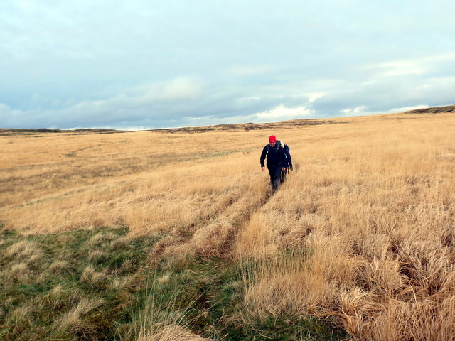
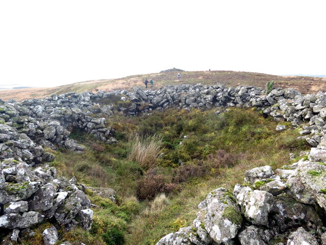
Country road passing through Allt y Graig Country road passing through Allt y Graig in the Cothi valley.
Country road passing through Allt y Graig
Country road passing through Allt y Graig in the Cothi valley.
Road beside Afon Cothi Country road beside Afon Cothi to the east of Cwrt-y-Cadno.
Road beside Afon Cothi
Country road beside Afon Cothi to the east of Cwrt-y-Cadno.
Road in Cothi valley Field gate beside a road in the Cothi valley.
Road in Cothi valley
Field gate beside a road in the Cothi valley.
Allt y Berth in the Cothi valley
Ordnance Survey Cut Mark This OS cut mark can be found on the NW parapet of the bridge over the Afon Cothi. It marks a point 195.493m above mean sea level.
Ordnance Survey Cut Mark
This OS cut mark can be found on the NW parapet of the bridge over the Afon Cothi. It marks a point 195.493m above mean sea level.
Blaen Dar Cerddwyr yn cael seibiant ger Blaen Dar. 

Walkers having a breather near Blaen Dar (trans. the source of the Dar ([oak] river).
Blaen Dar
Cerddwyr yn cael seibiant ger Blaen Dar. Walkers having a breather near Blaen Dar (trans. the source of the Dar ([oak] river).
Banc y Ddau Fryn Cerddwyr yn dilyn llwybr mewn lleoliad a elwir Banc y Ddau Fryn.

Walkers following a path at a location known as Banc y Ddau Fryn (trans. hillock of the two hills).
Banc y Ddau Fryn
Cerddwyr yn dilyn llwybr mewn lleoliad a elwir Banc y Ddau Fryn. Walkers following a path at a location known as Banc y Ddau Fryn (trans. hillock of the two hills).
Pen Cerrigdiddos Cerddwyr mewn lleoliad o'r enw Pen Cerrigdiddos. Dywedir bod y garreg yn faenhir gwympedig.

Walkers at a location known as Pen Cerrigdiddos (trans. top of the watertight stones). The boulder is said to be a recumbent standing stone.
Pen Cerrigdiddos
Cerddwyr mewn lleoliad o'r enw Pen Cerrigdiddos. Dywedir bod y garreg yn faenhir gwympedig. Walkers at a location known as Pen Cerrigdiddos (trans. top of the watertight stones). The boulder is said to be a recumbent standing stone.
Cwrt y Cadno Cyrraedd pentre bach gwledig Cwrt y Cadno. 

Entering the little rural village of Cwrt y Cadno (trans. Court of the fox).
Cwrt y Cadno
Cyrraedd pentre bach gwledig Cwrt y Cadno. Entering the little rural village of Cwrt y Cadno (trans. Court of the fox).
Tuat at Gwrt y Cadno / Towards Cwrt y Cadno Heol fach wledig yn mynd i gyfeiriad pentre bach Cwrt y Cadno.

A minor rural road heading towards the little village of Cwrt y Cadno (trans. court of the fox).
Tuat at Gwrt y Cadno / Towards Cwrt y Cadno
Heol fach wledig yn mynd i gyfeiriad pentre bach Cwrt y Cadno. A minor rural road heading towards the little village of Cwrt y Cadno (trans. court of the fox).
Llwybr ceffyl ger Pentwyn / A bridleway near Pentwyn Llwybr ceffyl ger Ffarm Pentwyn yn dringo i gyfeiriad Mynydd Mallaen.

A bridleway near Pentwyn Farm (trans. top of the hillock) ascends towards Mynydd Mallaen (trans. mountain of Llaen's plain).
Llwybr ceffyl ger Pentwyn / A bridleway near Pentwyn
Llwybr ceffyl ger Ffarm Pentwyn yn dringo i gyfeiriad Mynydd Mallaen. A bridleway near Pentwyn Farm (trans. top of the hillock) ascends towards Mynydd Mallaen (trans. mountain of Llaen's plain).
Llwybr i Gwrt y Cadno / Path to Cwrt y Cadno Llwybr ceffyl yn mynd i lawr y waered i gyfeiriad pentre bach Cwrty Cadno.

A bridleway descends the hill in the direction of the little village of Cwrt y Cadno (trans. court of the fox).
Llwybr i Gwrt y Cadno / Path to Cwrt y Cadno
Llwybr ceffyl yn mynd i lawr y waered i gyfeiriad pentre bach Cwrty Cadno. A bridleway descends the hill in the direction of the little village of Cwrt y Cadno (trans. court of the fox).
Llwybr Ceffyl Cwrt y Cadno bridleway Llwybr ceffyl yn arwain i lawr o Fynydd Mallaen at dreflan Cwrt y Cadno. Yn y pellter gellir gweld Capel Cwrtycadno.

A bridleway leading down from Mynydd Mallaen (trans. plains of Llain) Mountain to the hamlet of Cwrtycadno (trans. Court of the fox). Capel Cwrtycadno Chapel can be seen in the distance.
Llwybr Ceffyl Cwrt y Cadno bridleway
Llwybr ceffyl yn arwain i lawr o Fynydd Mallaen at dreflan Cwrt y Cadno. Yn y pellter gellir gweld Capel Cwrtycadno. A bridleway leading down from Mynydd Mallaen (trans. plains of Llain) Mountain to the hamlet of Cwrtycadno (trans. Court of the fox). Capel Cwrtycadno Chapel can be seen in the distance.
Hen Ysgol Cwrtycadno Old School Hen Ysgol Cwrtycadno sy wedi bod am flynyddoedd yn eiddo i Ysgol Gyfun Rhydfelen fel canolfan weithgareddau.

Cwrtycadno (tran. fox court) Old School has been for years the property of Rhydfelen (trans. brown ford) Comprehensive School and used as an activity centre.
Hen Ysgol Cwrtycadno Old School
Hen Ysgol Cwrtycadno sy wedi bod am flynyddoedd yn eiddo i Ysgol Gyfun Rhydfelen fel canolfan weithgareddau. Cwrtycadno (tran. fox court) Old School has been for years the property of Rhydfelen (trans. brown ford) Comprehensive School and used as an activity centre.
Crugiau Merched Carn wedi ei haflonyddu ac un o ddwy a elwir Crugiau Merched ar Fynydd Mallaen. Mae'r ail garn a'r piler triongli i'w gweld ar y gorwel.

A hollowed out cairn and one of two known as Crugiau Merched (trans. girls' / ladies' cairns) on Mynydd Mallaen (trans. the mountain plain of Llaen). The other cairn and trig point can be seen in the horizon.
Crugiau Merched
Carn wedi ei haflonyddu ac un o ddwy a elwir Crugiau Merched ar Fynydd Mallaen. Mae'r ail garn a'r piler triongli i'w gweld ar y gorwel. A hollowed out cairn and one of two known as Crugiau Merched (trans. girls' / ladies' cairns) on Mynydd Mallaen (trans. the mountain plain of Llaen). The other cairn and trig point can be seen in the horizon.
Llwybr ceffyl i Fynydd Mallaen / Bridleway to Mynydd Mallaen Llwybr ceffyl yn dringo tuag at Fynydd Mallaen.

A bridleway ascends towards Mynydd Mallaen (trans. mountain of Llaen's plain).
Llwybr ceffyl i Fynydd Mallaen / Bridleway to Mynydd Mallaen
Llwybr ceffyl yn dringo tuag at Fynydd Mallaen. A bridleway ascends towards Mynydd Mallaen (trans. mountain of Llaen's plain).
Llwybr ceffyl i Fynydd Mallaen / Bridleway to Mynydd Mallaen Llwybr ceffyl yn dringo at Fynydd Mallaen.

A bridleway ascends towards Mynydd Mallaen (trans. mountain of Llaen's plain).
Llwybr ceffyl i Fynydd Mallaen / Bridleway to Mynydd Mallaen
Llwybr ceffyl yn dringo at Fynydd Mallaen. A bridleway ascends towards Mynydd Mallaen (trans. mountain of Llaen's plain).
Mynediad i'r mynydd / Access to the mountain Gât yn rhoi mynediad i rostir agored a elwir Mynydd Mallaen (Mallân ar lafar).

A gate gives access to an open moorland known as Mynydd Mallaen (trans. mountain of Llaen's plain).
Mynediad i'r mynydd / Access to the mountain
Gât yn rhoi mynediad i rostir agored a elwir Mynydd Mallaen (Mallân ar lafar). A gate gives access to an open moorland known as Mynydd Mallaen (trans. mountain of Llaen's plain).
Show me another place!

Allt Isaf is located at Grid Ref: SN7045 (Lat: 52.090445, Lng: -3.8921737)

Unitary Authority: Carmarthenshire

Police Authority: Dyfed Powys

What 3 Words

///passport.cable.overture. Near Llandovery, Carmarthenshire

Nearby Locations

Allt Isaf

Related Wikis

Mynydd Mallaen

Mynydd Mallaen (Welsh: [ˈmənɨð ˈmaɬai̯n]) is an expansive plateau to the northwest of Cilycwm in northeast Carmarthenshire, Wales. It forms part of the...

Ffarmers

Ffarmers is a village near Lampeter, in the north of Carmarthenshire, Wales. It was named after the old "Farmers' Arms" public house, which is now closed...

Cynwyl Gaeo

Cynwyl Gaeo is a parish and community located in rural Carmarthenshire, Wales, near the boundary with Ceredigion, in the upper Cothi valley about halfway...

Dolaucothi Estate

The Dolaucothi Estate (also Dolaucothy) is situated about 1 mile (1.6 km) north-west of the village of Caio up the Cothi Valley in the community of Cynwyl...

Caio, Carmarthenshire

Caio (or Caeo) is a village in the county of Carmarthenshire, south-west Wales, sited near to the Dolaucothi Gold Mines. == Location == It is located between...

Llanycrwys

Llanycrwys is a hamlet and community located in Carmarthenshire, Wales. Situated in the historical Cayo Hundred in the Union of Lampeter, it is situated...

Aberbowlan

Aberbowlan is a small village in Carmarthenshire. It is located in the north of the county, 8 miles (13 km) to the north-east of the town of Llandovery...

Dolaucothi Gold Mines

The Dolaucothi Gold Mines (pronounced [ˌdɔlaiˈkɔθɪ]; Welsh: Mwynfeydd Aur Dolaucothi) (grid reference SN662403), also known as the Ogofau Gold Mine, are...

Nearby Amenities

Located within 500m of 52.090445,-3.8921737
Aberbranddu
Place: farm
Lat/Long: 52.0925275/-3.8881838
The data included in this document is from www.openstreetmap.org. The data is made available under ODbL.

Have you been to Allt Isaf?

Leave your review of Allt Isaf below (or comments, questions and feedback).