Burnham Thorpe

Settlement in Norfolk King's Lynn and West Norfolk

England

Burnham Thorpe

Creake Abbey Looking east along the nave <span class="nowrap"><a title="https://historicengland.org.uk/listing/the-list/list-entry/1015271?section=official-listing" rel="nofollow ugc noopener" href="https://historicengland.org.uk/listing/the-list/list-entry/1015271?section=official-listing">Link</a><img style="margin-left:2px;" alt="External link" title="External link - shift click to open in new window" src="https://s1.geograph.org.uk/img/external.png" width="10" height="10"/></span>
Creake Abbey Credit: Sandy Gerrard

Burnham Thorpe is a village located in the county of Norfolk, England. Situated about 2 miles inland from the North Norfolk coast, it lies approximately 25 miles northwest of the city of Norwich. The village is part of the Burnhams, a group of villages collectively known for their picturesque landscapes and charming rural character.

The history of Burnham Thorpe can be traced back to medieval times, with records dating back to the 11th century. It was once a thriving agricultural community, characterized by its fertile farmland and traditional Norfolk cottages. Today, the village still retains much of its historic charm, with many of its original buildings and cottages still intact.

One of the notable features of Burnham Thorpe is its association with Admiral Horatio Nelson, one of Britain's most celebrated naval heroes. Nelson was born in the village in 1758, and his childhood home, known as Nelson's Birthplace, is now a museum dedicated to his life and achievements. The museum offers visitors a glimpse into Nelson's early years and his naval career.

Surrounded by rolling countryside, Burnham Thorpe is a peaceful and idyllic place to visit. The village is well-connected to the nearby coastal towns of Wells-next-the-Sea and Holkham, which offer stunning beaches and nature reserves. Its proximity to the Norfolk Coast Area of Outstanding Natural Beauty also makes it a popular destination for outdoor enthusiasts and nature lovers.

Overall, Burnham Thorpe is a charming village with a rich history and beautiful countryside, making it a delightful place to explore for visitors seeking a tranquil retreat in the heart of Norfolk.

If you have any feedback on the listing, please let us know in the comments section below.

Burnham Thorpe Images

Images are sourced within 2km of 52.938037/0.756449 or Grid Reference TF8541. Thanks to Geograph Open Source API. All images are credited.

Creake Abbey Looking east along the nave <span class="nowrap"><a title="https://historicengland.org.uk/listing/the-list/list-entry/1015271?section=official-listing" rel="nofollow ugc noopener" href="https://historicengland.org.uk/listing/the-list/list-entry/1015271?section=official-listing">Link</a><img style="margin-left:2px;" alt="External link" title="External link - shift click to open in new window" src="https://s1.geograph.org.uk/img/external.png" width="10" height="10"/></span>
Creake Abbey
Looking east along the nave LinkExternal link
Creake Abbey North transept <span class="nowrap"><a title="https://historicengland.org.uk/listing/the-list/list-entry/1015271?section=official-listing" rel="nofollow ugc noopener" href="https://historicengland.org.uk/listing/the-list/list-entry/1015271?section=official-listing">Link</a><img style="margin-left:2px;" alt="External link" title="External link - shift click to open in new window" src="https://s1.geograph.org.uk/img/external.png" width="10" height="10"/></span>
Creake Abbey
North transept LinkExternal link
Creake Abbey
Creake Abbey
Creake Abbey Looking westwards towards the car park. The Abbey was a victim not of Henry VIII but of fire and plague.  The buildings were at one time owned by Christ's College, Cambridge, but the ruins are now in the care of English Heritage. <span class="nowrap"><a title="https://www.english-heritage.org.uk/visit/places/creake-abbey/history/" rel="nofollow ugc noopener" href="https://www.english-heritage.org.uk/visit/places/creake-abbey/history/">Link</a><img style="margin-left:2px;" alt="External link" title="External link - shift click to open in new window" src="https://s1.geograph.org.uk/img/external.png" width="10" height="10"/></span>
Creake Abbey
Looking westwards towards the car park. The Abbey was a victim not of Henry VIII but of fire and plague. The buildings were at one time owned by Christ's College, Cambridge, but the ruins are now in the care of English Heritage. LinkExternal link
Creake Abbey: Site of the nave and pulpitum
Creake Abbey: Site of the nave and pulpitum, later c13th work
Creake Abbey: Site of the nave and pulpitum, later c13th and c15th work under the arch
Creake Abbey: Site of the nave and pulpitum, later c13th and c15th work under the arch Detail of the c15th work.
Creake Abbey: Site of the nave and pulpitum, later c13th and c15th work under the arch
Detail of the c15th work.
Creake Abbey: The pulpitum wall
Creake Abbey: The pulpitum and choir walls
Creake Abbey: The choir north wall
Creake Abbey <span class="nowrap"><a title="https://historicengland.org.uk/listing/the-list/list-entry/1077815?section=official-list-entry" rel="nofollow ugc noopener" href="https://historicengland.org.uk/listing/the-list/list-entry/1077815?section=official-list-entry">Link</a><img style="margin-left:2px;" alt="External link" title="External link - shift click to open in new window" src="https://s1.geograph.org.uk/img/external.png" width="10" height="10"/></span>
Creake Abbey
Remains of Creake Abbey A ruined Augustinian abbey in the care of English Heritage.
Remains of Creake Abbey
A ruined Augustinian abbey in the care of English Heritage.
Remains of Creake Abbey A ruined Augustinian abbey in the care of English Heritage.
Remains of Creake Abbey
A ruined Augustinian abbey in the care of English Heritage.
The River Burn at Creake Abbey
Creake Abbey Creake Abbey dates from the early 13th century when it was established for a community of Augustinian canons. For a period they ran a hospital for the sick and needy. However, the church was destroyed by fire in 1480 and although the canons tried to struggle on they were subsequently wiped out by the plague. Consequently, the abbey didn't survive long enough to be dissolved by Henry VIII.
Creake Abbey
Creake Abbey dates from the early 13th century when it was established for a community of Augustinian canons. For a period they ran a hospital for the sick and needy. However, the church was destroyed by fire in 1480 and although the canons tried to struggle on they were subsequently wiped out by the plague. Consequently, the abbey didn't survive long enough to be dissolved by Henry VIII.
Creake Abbey Detail of part of the ruins of this former Augustinian abbey.
Creake Abbey
Detail of part of the ruins of this former Augustinian abbey.
Creake Abbey Creake Abbey is a ruined abbey in Norfolk, England, situated alongside the River Burn and a mile to the north of the village of North Creake. The abbey church was dedicated to Saint Mary.

The site was originally occupied by an almshouse for the poor, and was founded by the Augustinians as a priory in the 12th century. Voluntary grants of alms by the leading families of Nerford and Creake and by the faithful of the neighbourhood seem to have built up resources sufficiently to warrant elevation from Hospital to Priory and thence to Abbey, which happened in 1231. Henry III made a number of grants to Creake in its early years. Gifts of parish churches included Hapton and Wreningham, Gateley and St. Martin at Quarles and later in 1365 of St. Andrew, Great Ringstead.

The heyday of the Abbey was during the fourteenth century when there were but six canons, though the Rule required in addition to the abbot,prior and cellarer, a cantor, sacrist and kitchener, refectorian, infirmarian, almoner, master of novices and guest master,which according to Bedingfield, may have been posts filled in rotation or plurality. There will have been junior canons and, from time to time, novices. There would finally be numerous servants, tailors, laundresses and their assistants, the messor, shepherds and cowherds for the farm, not to mention of residents of the hospital. Unlike some of the abbeys thereabouts, it was still fulfilling its hospital function as late as 1397.

In 1483, a fire swept through the abbey, damaging the church and several of the other buildings, such that it was beyond the capacity of the convent to restore it. The abbot appealed to the king as patron of the house, and Richard III, 'moved with pite' gave the abbey by way of alms towards the rebuilding of the handsome sum of £46 13s.4d. to be paid out the revenues of the lordship of Fakenham. Robert Walsingham, appointed abbot in 1491, began extensive rebuilding of the quire and presbytery and Sir William Calthorpe left £74 towards the completion of the work. By 1503 the work was well advanced and lands given by Waler Aslak were for the completion of the north side of the quire. By this time the abbot was Giles Sherington. However, in 1506 an outbreak of the 'sweating sickness' wiped out the monastic community, the abbot himself being the last to die. The abbey site and estate was given to Lady Margaret Beaufort in 1507, and ended up in the ownership of Christ's College, Cambridge.

A few sections of the church walls remain standing, and demonstrate their traditional Norfolk flintwork. There are some remaining carved details in the window arches and doorways. However, little else survives apart from foundations. The site is now in the care of English Heritage, and freely accessible to the public.

From wiki.
Creake Abbey
Creake Abbey is a ruined abbey in Norfolk, England, situated alongside the River Burn and a mile to the north of the village of North Creake. The abbey church was dedicated to Saint Mary. The site was originally occupied by an almshouse for the poor, and was founded by the Augustinians as a priory in the 12th century. Voluntary grants of alms by the leading families of Nerford and Creake and by the faithful of the neighbourhood seem to have built up resources sufficiently to warrant elevation from Hospital to Priory and thence to Abbey, which happened in 1231. Henry III made a number of grants to Creake in its early years. Gifts of parish churches included Hapton and Wreningham, Gateley and St. Martin at Quarles and later in 1365 of St. Andrew, Great Ringstead. The heyday of the Abbey was during the fourteenth century when there were but six canons, though the Rule required in addition to the abbot,prior and cellarer, a cantor, sacrist and kitchener, refectorian, infirmarian, almoner, master of novices and guest master,which according to Bedingfield, may have been posts filled in rotation or plurality. There will have been junior canons and, from time to time, novices. There would finally be numerous servants, tailors, laundresses and their assistants, the messor, shepherds and cowherds for the farm, not to mention of residents of the hospital. Unlike some of the abbeys thereabouts, it was still fulfilling its hospital function as late as 1397. In 1483, a fire swept through the abbey, damaging the church and several of the other buildings, such that it was beyond the capacity of the convent to restore it. The abbot appealed to the king as patron of the house, and Richard III, 'moved with pite' gave the abbey by way of alms towards the rebuilding of the handsome sum of £46 13s.4d. to be paid out the revenues of the lordship of Fakenham. Robert Walsingham, appointed abbot in 1491, began extensive rebuilding of the quire and presbytery and Sir William Calthorpe left £74 towards the completion of the work. By 1503 the work was well advanced and lands given by Waler Aslak were for the completion of the north side of the quire. By this time the abbot was Giles Sherington. However, in 1506 an outbreak of the 'sweating sickness' wiped out the monastic community, the abbot himself being the last to die. The abbey site and estate was given to Lady Margaret Beaufort in 1507, and ended up in the ownership of Christ's College, Cambridge. A few sections of the church walls remain standing, and demonstrate their traditional Norfolk flintwork. There are some remaining carved details in the window arches and doorways. However, little else survives apart from foundations. The site is now in the care of English Heritage, and freely accessible to the public. From wiki.
Show me another place!

Burnham Thorpe is located at Grid Ref: TF8541 (Lat: 52.938037, Lng: 0.756449)

Administrative County: Norfolk

District: King's Lynn and West Norfolk

Police Authority: Norfolk

What 3 Words

///dormant.spoiler.regulates. Near Wells-next-the-Sea, Norfolk

Related Wikis

Burnham Thorpe

Burnham Thorpe is a hamlet and civil parish on the River Burn and near the coast of Norfolk, England. It is famous for being the birthplace of Vice Admiral...

Holkham Brick Pit

Holkham Brick Pit is a 0.5-hectare (1.2-acre) geological Site of Special Scientific Interest west of Wells-next-the-Sea in Norfolk. It is a Geological...
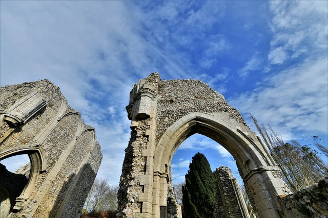
Peterstone Priory

Peterstone Priory a house of Augustinian Canons, was a priory in Burnham Overy, Norfolk, England. It was founded before 1200 and incorporated 1449. �...

Norfolk Burnhams

The Norfolk Burnhams are a group of adjacent villages on the north coast of Norfolk, England. The villages are located near a large natural bay named Brancaster...

Nearby Amenities

Located within 500m of 52.938037,0.756449
Post Box
Operator: Royal Mail
Post Box Mounting: pier
Post Box Type: lamp
Ref: PE31 453
Royal Cypher: EIIR
Royal Cypher Wikidata: Q33102113
Source: survey
Lat/Long: 52.938011/0.7569614
Blacksmiths Lane, adj
Naptan AtcoCode: 2900B651
Naptan Bearing: SE
Naptan BusStopType: CUS
Naptan CommonName: Blacksmiths Lane
Naptan Indicator: adj
Naptan Landmark: Blacksmiths Lane
Naptan Locality: Burnham Thorpe
Naptan NaptanCode: nfoagpmd
Naptan Street: Creake Road
Naptan Verified: no
Source: naptan_import
Lat/Long: 52.9376189/0.7558156
Blacksmiths Lane, opp
Naptan AtcoCode: 2900B652
Naptan Bearing: NW
Naptan BusStopType: CUS
Naptan CommonName: Blacksmiths Lane
Naptan Indicator: opp
Naptan Landmark: Blacksmiths Lane
Naptan Locality: Burnham Thorpe
Naptan NaptanCode: nfoagpmg
Naptan Street: Creake Road
Naptan Verified: no
Source: naptan_import
Lat/Long: 52.9374997/0.7559122
Bus Stop
Lowes Lane, adj
Naptan AtcoCode: 2900B653
Naptan Bearing: SE
Naptan CommonName: Lowes Lane
Naptan Indicator: adj
Naptan Landmark: village sign
Naptan Locality: Burnham Thorpe
Naptan NaptanCode: nfoagpmj
Naptan Street: Walsingham Road
Naptan Verified: no
Shelter: yes
Source: naptan_import
Lat/Long: 52.9380026/0.7571052
Lowes Lane, opp
Naptan AtcoCode: 2900B654
Naptan Bearing: NW
Naptan BusStopType: CUS
Naptan CommonName: Lowes Lane
Naptan Indicator: opp
Naptan Landmark: opp village sign
Naptan Locality: Burnham Thorpe
Naptan NaptanCode: nfoagpmp
Naptan Street: Walsingham Road
Naptan Verified: no
Source: naptan_import
Lat/Long: 52.9380271/0.7568239
Entrance: main
Lat/Long: 52.941267/0.7547826
Entrance: yes
Lat/Long: 52.9411581/0.7547107
Give Way
Lat/Long: 52.9388052/0.7574553
Give Way
Lat/Long: 52.938827/0.7573936
Give Way
Lat/Long: 52.9359785/0.7621605
Give Way
Lat/Long: 52.9380619/0.7564121
Give Way
Lat/Long: 52.9375503/0.7559366
Give Way
Lat/Long: 52.9376099/0.7577885
Give Way
Lat/Long: 52.9369183/0.7572465
Give Way
Lat/Long: 52.9397917/0.7526481
Give Way
Lat/Long: 52.9392326/0.7539237
Burnham Thorpe
Inscription: Birthplace of Horatio Nelson / 29th September, 1758. / Nile / Copenhagen / Trafalgar / Vanguard / Elephant / Victory
Man Made: village_sign
Material: wood
Lat/Long: 52.9380422/0.7568993
Power: pole
Lat/Long: 52.9368726/0.7629248
Power: pole
Lat/Long: 52.9377366/0.7621443
Power: pole
Lat/Long: 52.9385974/0.7613665
Power: pole
Lat/Long: 52.9403982/0.7608515
Power: pole
Lat/Long: 52.9393119/0.7612243
Power: pole
Lat/Long: 52.9403093/0.7610084
Power: pole
Lat/Long: 52.9410633/0.7608341
Power: pole
Lat/Long: 52.942059/0.7554978
Bench
Lat/Long: 52.9379459/0.7571863
The data included in this document is from www.openstreetmap.org. The data is made available under ODbL.

Have you been to Burnham Thorpe?

Leave your review of Burnham Thorpe below (or comments, questions and feedback).