Burnham-On-Crouch

Settlement in Essex Maldon

England

Burnham-On-Crouch

Old pontoons at Wallasea Marina These wooden pontoons, now beached, abandoned and decaying on the saltings, once formed part of the WW2 coastal defence booms in the wider Thames Estuary.
A few of the many hundreds originally deployed were repurposed at the end of hostilities to form a floating dock at Wallasea marina and remained in service for some years before being replaced with the current modern pontoon berths
Old pontoons at Wallasea Marina Credit: John Myers

Burnham-On-Crouch is a charming town located on the north bank of the River Crouch in the county of Essex, England. Situated about 60 miles northeast of London, Burnham-On-Crouch is a popular destination for boating enthusiasts and those seeking a peaceful coastal retreat.

The town has a rich maritime history, with a long-established connection to sailing and fishing. The picturesque Burnham-on-Crouch Yacht Club, founded in 1893, is one of the oldest and most prestigious yacht clubs in the UK. It attracts sailors from around the world who come to enjoy the excellent sailing conditions on the River Crouch and the nearby North Sea.

Visitors to Burnham-On-Crouch can explore its quaint streets lined with traditional houses, many of which date back to the 18th and 19th centuries. The town also boasts a selection of independent shops, cafes, and restaurants, offering a range of local produce and freshly caught seafood.

Nature enthusiasts will appreciate the town's proximity to the Dengie Peninsula, a designated Area of Outstanding Natural Beauty. The area is home to a variety of bird species, including migratory birds, making it a popular spot for birdwatching. The marshes and creeks that surround the town are also ideal for leisurely walks and wildlife spotting.

For those interested in history, Burnham-On-Crouch is home to several historic landmarks, including St. Mary's Church, a Grade I listed building dating back to the 13th century. The town also hosts various events throughout the year, such as the Burnham Week regatta and the Burnham Art Trail, which showcase the town's vibrant community spirit.

In summary, Burnham-On-Crouch is a delightful coastal town that offers a perfect mix of maritime heritage, natural beauty, and relaxing charm, making it an attractive destination for locals and visitors alike.

If you have any feedback on the listing, please let us know in the comments section below.

Burnham-On-Crouch Images

Images are sourced within 2km of 51.625213/0.817738 or Grid Reference TQ9595. Thanks to Geograph Open Source API. All images are credited.

Old pontoons at Wallasea Marina These wooden pontoons, now beached, abandoned and decaying on the saltings, once formed part of the WW2 coastal defence booms in the wider Thames Estuary.
A few of the many hundreds originally deployed were repurposed at the end of hostilities to form a floating dock at Wallasea marina and remained in service for some years before being replaced with the current modern pontoon berths
Old pontoons at Wallasea Marina
These wooden pontoons, now beached, abandoned and decaying on the saltings, once formed part of the WW2 coastal defence booms in the wider Thames Estuary. A few of the many hundreds originally deployed were repurposed at the end of hostilities to form a floating dock at Wallasea marina and remained in service for some years before being replaced with the current modern pontoon berths
Grapnells Farm
Grapnells Farm
Anti-predator ditch and fence The ditch encloses the Marsh Flats grazing area and lagoons - a major nesting area within the reserve
Anti-predator ditch and fence
The ditch encloses the Marsh Flats grazing area and lagoons - a major nesting area within the reserve
Anti-predator ditch and fence Western perimeter of Marsh Flats
Anti-predator ditch and fence
Western perimeter of Marsh Flats
War Memorial Burnham-on-Crouch
War Memorial
Burnham-on-Crouch
Burnham Wick sluice Pannel's Brook and solar farm
Burnham Wick sluice
Pannel's Brook and solar farm
Burnham Yacht Harbour Marina
Channel through the mudflats - RSPB Wallasea Island The following adapted from the RSPB website <span class="nowrap"><a title="https://www.rspb.org.uk/reserves-and-events/reserves-a-z/wallasea-island/" rel="nofollow ugc noopener" href="https://www.rspb.org.uk/reserves-and-events/reserves-a-z/wallasea-island/">Link</a><img style="margin-left:2px;" alt="External link" title="External link - shift click to open in new window" src="https://s1.geograph.org.uk/img/external.png" width="10" height="10"/></span>

"The reserve covers more than 740ha, with all of the arable farmland now transformed to saltmarsh, mudflats, lagoons and grazing marsh.

There are six walking trails – Jubilee Marsh, Allfleets Marsh, Marsh Flats, South Trail, New Pool Trail and Beagle Trail, making over 15km of trail on the reserve. At the ends of Allfleets Marsh trail and Jubilee Marsh trail are two shelters providing a comfortable place to sit overlooking the river.

To create this magical landscape of marshland, lagoons, ditches and sea, more than three million tonnes of earth was brought by boat from the tunnels and shafts created by the Crossrail scheme in London. This allowed us to raise the land above sea level and place the soil in a way that created a new 115-hectare intertidal area of saltmarsh, islands and mudflats (known as Jubilee Marsh).

In addition, Crossrail helped us create saline lagoons, a creek network and grazing marsh. All of which means Wallasea Island is now a wildlife-rich habitat and a great place to visit.

Wallasea Island sits within a Special Protection Area which covers the Crouch and Roach estuaries, and which is special for overwintering waders and wildfowl including Brent Geese. Our work here increases the habitat for these birds both whilst roosting and feeding, as well as creating new grassland areas (wet and dry). The intertidal areas have been designed with climate change in mind, with long shallow slopes from the new seawall providing space for the saltmarsh to creep up as sea levels rise."
Channel through the mudflats - RSPB Wallasea Island
The following adapted from the RSPB website LinkExternal link "The reserve covers more than 740ha, with all of the arable farmland now transformed to saltmarsh, mudflats, lagoons and grazing marsh. There are six walking trails – Jubilee Marsh, Allfleets Marsh, Marsh Flats, South Trail, New Pool Trail and Beagle Trail, making over 15km of trail on the reserve. At the ends of Allfleets Marsh trail and Jubilee Marsh trail are two shelters providing a comfortable place to sit overlooking the river. To create this magical landscape of marshland, lagoons, ditches and sea, more than three million tonnes of earth was brought by boat from the tunnels and shafts created by the Crossrail scheme in London. This allowed us to raise the land above sea level and place the soil in a way that created a new 115-hectare intertidal area of saltmarsh, islands and mudflats (known as Jubilee Marsh). In addition, Crossrail helped us create saline lagoons, a creek network and grazing marsh. All of which means Wallasea Island is now a wildlife-rich habitat and a great place to visit. Wallasea Island sits within a Special Protection Area which covers the Crouch and Roach estuaries, and which is special for overwintering waders and wildfowl including Brent Geese. Our work here increases the habitat for these birds both whilst roosting and feeding, as well as creating new grassland areas (wet and dry). The intertidal areas have been designed with climate change in mind, with long shallow slopes from the new seawall providing space for the saltmarsh to creep up as sea levels rise."
Church Hall sluice Taken at the point where Paglesham Pool morphs into Paglesham Creek.
Church Hall sluice
Taken at the point where Paglesham Pool morphs into Paglesham Creek.
Footbridge at Church Hall sluice Taken at the point where Paglesham Pool morphs into Paglesham Creek.
Footbridge at Church Hall sluice
Taken at the point where Paglesham Pool morphs into Paglesham Creek.
Burnham-on-Crouch Station Towards Southminster
Burnham-on-Crouch Station
Towards Southminster
Merit unloading at Baltic Wharf, Wallasea Island General Cargo ship Merit, in from Riga with a load of timber. View from near Burnham Marina
Merit unloading at Baltic Wharf, Wallasea Island
General Cargo ship Merit, in from Riga with a load of timber. View from near Burnham Marina
Burnham-on-Crouch Boat Remains Just out of Burnham-on-Crouch at Ringwood Bar walking along the coastal path one comes to the first of a series of abandoned rotting boat carcasses. It looked to me like the remains of a Viking longboat which it most certainly was not. Doubtless the wind here would once have propelled the boat along the river Crouch, now it propels the wind turbine, one of many, seen on the horizon. A changing face of industry.
Burnham-on-Crouch Boat Remains
Just out of Burnham-on-Crouch at Ringwood Bar walking along the coastal path one comes to the first of a series of abandoned rotting boat carcasses. It looked to me like the remains of a Viking longboat which it most certainly was not. Doubtless the wind here would once have propelled the boat along the river Crouch, now it propels the wind turbine, one of many, seen on the horizon. A changing face of industry.
Burnham-on-Crouch Sunset Looking west at the Royal Corinthian Yacht Club as the sun just dipped below the horizon. Although a cold day was coming to an end already the pubs in town were bustling as a Friday night was starting.
Burnham-on-Crouch Sunset
Looking west at the Royal Corinthian Yacht Club as the sun just dipped below the horizon. Although a cold day was coming to an end already the pubs in town were bustling as a Friday night was starting.
Creeksea Place - north frontage Creeksea Place dates from 1569 but has been extensively rebuilt and added to over the centuries. Today the main house and its ancillary buildings serve a variety of leisure and social purposes.
Creeksea Place - north frontage
Creeksea Place dates from 1569 but has been extensively rebuilt and added to over the centuries. Today the main house and its ancillary buildings serve a variety of leisure and social purposes.
Creeksea Place - north frontage & extension Creeksea Place dates from 1569 but has been extensively rebuilt and added to over the centuries. Today the main house and its ancillary buildings serve a variety of leisure and social purposes.
Creeksea Place - north frontage & extension
Creeksea Place dates from 1569 but has been extensively rebuilt and added to over the centuries. Today the main house and its ancillary buildings serve a variety of leisure and social purposes.
Parlour Café, Creeksea Place Creeksea Place and its ancillary buildings have been developed as a centre for various functions including a wedding venue, a spa and fitness facility and two cafés one of which is seen here.
Parlour Café, Creeksea Place
Creeksea Place and its ancillary buildings have been developed as a centre for various functions including a wedding venue, a spa and fitness facility and two cafés one of which is seen here.
The Dog House Café, Creeksea Place This is one of the two cafés on the Creeksea Place site, the other being the Parlour Café (just visible to the left).
The Dog House Café, Creeksea Place
This is one of the two cafés on the Creeksea Place site, the other being the Parlour Café (just visible to the left).
Show me another place!

Burnham-On-Crouch is located at Grid Ref: TQ9595 (Lat: 51.625213, Lng: 0.817738)

Administrative County: Essex

District: Maldon

Police Authority: Essex

What 3 Words

///business.gravitate.novels. Near Burnham-on-Crouch, Essex

Nearby Locations

Burnham-On-Crouch

Related Wikis

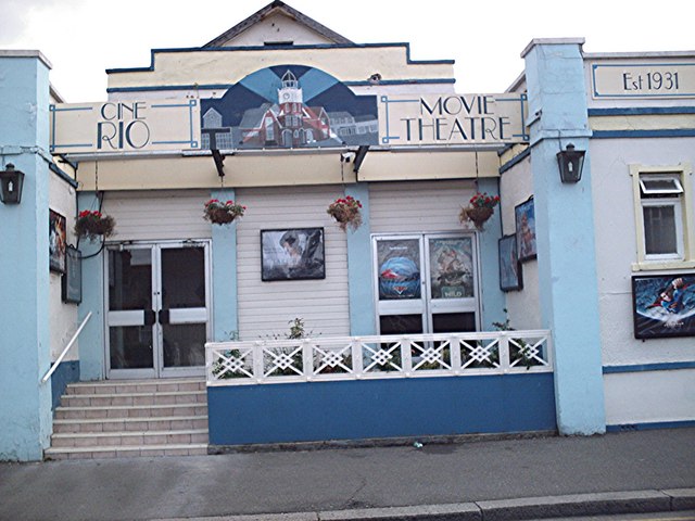
Rio Cinema (Burnham on Crouch)

The Rio Cinema is a purpose-built, two-screen, 280-seat cinema in Burnham on Crouch, Essex in the United Kingdom. The building dates from 1931. The Burnham...

Royal Corinthian Yacht Club

The Royal Corinthian Yacht Club is a watersports organisation based at Burnham-on-Crouch, Essex. == History == === Early history === The club was founded...

Burnham-on-Crouch & District Museum

The Burnham-on-Crouch and District Museum, located in Burnham-on-Crouch, Essex, is a registered charity run by members of the Burnham History Society,...

Burnham-on-Crouch

Burnham-on-Crouch is a town and civil parish in the Maldon District of Essex, in the East of England; it lies on the north bank of the River Crouch. It...

Nearby Amenities

Located within 500m of 51.625213,0.817738
Source: PGS
Lat/Long: 51.6258687/0.8116489
Source: PGS
Lat/Long: 51.6257355/0.8126437
Source: PGS
Lat/Long: 51.6254993/0.8145762
Source: PGS
Lat/Long: 51.6249519/0.8173295
Source: PGS
Lat/Long: 51.6244437/0.8188943
Source: PGS
Lat/Long: 51.6245083/0.8189882
Source: PGS
Lat/Long: 51.6238714/0.8211098
Source: PGS
Lat/Long: 51.6238518/0.8215178
Source: PGS
Lat/Long: 51.6237164/0.8218609
Source: PGS
Lat/Long: 51.6232412/0.8229636
Source: PGS
Lat/Long: 51.6232079/0.8233284
Noexit: yes
Lat/Long: 51.6263877/0.8168934
Bus Stop
Burnham Library
Bench: no
Bin: no
Bus: yes
Naptan AtcoCode: 150012005009
Naptan Bearing: N
Naptan CommonName: Burnham Library
Naptan Crossing: Queens Road
Naptan Indicator: Opp
Naptan Landmark: Burnham Library
Naptan NaptanCode: esxawtmd
Naptan Street: Station Road
Public Transport: platform
Shelter: no
Source: naptan_import
Lat/Long: 51.6292251/0.814655
Bus Stop
Burnham Library
Bench: no
Bin: no
Bus: yes
Naptan AtcoCode: 150012005010
Naptan Bearing: S
Naptan CommonName: Burnham Library
Naptan Crossing: Queens Road
Naptan Indicator: o/s
Naptan Landmark: Burnham Library
Naptan NaptanCode: esxawtmg
Naptan Street: Station Road
Public Transport: platform
Shelter: no
Source: naptan_import
Lat/Long: 51.6292629/0.8147885
Bus Stop
Burnham Cinema
Bench: no
Bin: no
Bus: yes
Naptan AtcoCode: 150012005011
Naptan Bearing: NW
Naptan CommonName: Burnham Cinema
Naptan Indicator: Opp
Naptan Landmark: Burnham Cinema
Naptan NaptanCode: esxawtmj
Naptan Street: Station Road
Public Transport: platform
Shelter: no
Source: naptan_import
Lat/Long: 51.6269641/0.8149528
Bus Stop
Burnham Cinema
Bus: yes
Naptan AtcoCode: 150012005012
Naptan Bearing: SE
Naptan CommonName: Burnham Cinema
Naptan Indicator: o/s
Naptan Landmark: Burnham Cinema
Naptan NaptanCode: esxawtmp
Naptan Street: Station Road
Naptan Verified: no
Public Transport: platform
Source: naptan_import
Lat/Long: 51.6267726/0.8151881
Bus Stop
Clock Tower
Bench: yes
Bin: yes
Bus: yes
Lit: yes
Naptan AtcoCode: 1500IM2082
Naptan Bearing: W
Naptan CommonName: Clock Tower
Naptan Indicator: o/s
Naptan Landmark: Clock Tower
Naptan NaptanCode: esxawtmt
Naptan Street: High Street
Public Transport: platform
Shelter: no
Source: naptan_import
Lat/Long: 51.6252617/0.8192981
Bus Stop
Clock Tower
Bus: yes
Naptan AtcoCode: 1500IM2082Y
Naptan Bearing: E
Naptan BusStopType: CUS
Naptan CommonName: Clock Tower
Naptan Indicator: Opp
Naptan Landmark: Clock Tower
Naptan NaptanCode: esxjdgwm
Naptan Street: High Street
Naptan Verified: no
Public Transport: platform
Source: naptan_import
Lat/Long: 51.6253383/0.8193236
Post Box
Lat/Long: 51.6263411/0.8155467
Bicycle Parking
Bicycle Parking: stands
Covered: no
Lat/Long: 51.6253651/0.8195818
Post Box
Post Box Type: pillar
Lat/Long: 51.6253874/0.8194291
Crossing
Crossing: marked
Crossing Island: no
Crossing Markings: yes
Tactile Paving: yes
Lat/Long: 51.6273485/0.8148243
Crossing
Crossing: marked
Crossing Island: no
Crossing Markings: yes
Tactile Paving: yes
Lat/Long: 51.6289015/0.8145406
Toilets
Pooh Corner
Female: yes
Male: yes
Note: Near Harbour Authority
Lat/Long: 51.6250041/0.817556
Noexit: yes
Lat/Long: 51.6251834/0.8115846
Noexit: yes
Lat/Long: 51.6252276/0.8113076
War Memorial
Historic: memorial
Memorial: war_memorial
Lat/Long: 51.6253802/0.8165397
Atm
Operator: Tesco
Lat/Long: 51.6277357/0.8148541
Bench
Backrest: yes
Material: wood
Lat/Long: 51.6260421/0.8108423
Noexit: yes
Lat/Long: 51.6288295/0.8135993
Noexit: yes
Lat/Long: 51.6269921/0.8192693
Board Type: board
Information: board
Tourism: information
Lat/Long: 51.6253896/0.8188101
Post Box
Operator: Royal Mail
Operator Wikidata: Q638098
Post Box Mounting: brick_pillar
Post Box Type: wall
Royal Cypher: EIIR
Lat/Long: 51.6278361/0.8188253
Addr City: Burnham-On-Crouch
Addr Country: GB
Addr Housenumber: 30
Addr Street: Providence
Lat/Long: 51.6264907/0.8195603
Seamark Buoy Lateral Category: starboard
Seamark Buoy Lateral Colour: green
Seamark Buoy Lateral Shape: conical
Seamark Buoy Lateral System: iala-a
Seamark Name: Burnham Fairway No.9
Seamark Type: buoy_lateral
Source: Crouch Harbour Authority;survey
Lat/Long: 51.6222852/0.8125929
Entrance: main
Lat/Long: 51.6258401/0.8126643
Entrance: main
Lat/Long: 51.625834/0.8123121
Crossing
Crossing: unmarked
Crossing Markings: no
Lat/Long: 51.625382/0.8197193
Crossing
Crossing: unmarked
Crossing Markings: no
Lat/Long: 51.625428/0.8188954
Crossing
Crossing: unmarked
Crossing Markings: no
Tactile Paving: no
Lat/Long: 51.6253562/0.8171711
Crossing: informal
Lat/Long: 51.6263958/0.8154889
Crossing
Crossing: unmarked
Crossing Island: no
Crossing Markings: no
Tactile Paving: yes
Lat/Long: 51.6272728/0.8149501
Crossing
Crossing: unmarked
Crossing Markings: no
Tactile Paving: yes
Lat/Long: 51.6274851/0.8147731
Crossing
Crossing: unmarked
Crossing Island: no
Crossing Markings: no
Tactile Paving: no
Lat/Long: 51.6286824/0.8145023
Crossing
Crossing: unmarked
Crossing Island: no
Crossing Markings: no
Tactile Paving: no
Lat/Long: 51.6252187/0.8219981
Crossing
Crossing: unmarked
Crossing Island: no
Crossing Markings: no
Tactile Paving: yes
Lat/Long: 51.6252566/0.8187462
Crossing
Crossing: unmarked
Crossing Island: no
Crossing Markings: no
Tactile Paving: yes
Lat/Long: 51.6252558/0.8176691
Crossing
Crossing: unmarked
Crossing Island: no
Crossing Markings: no
Tactile Paving: no
Lat/Long: 51.6268418/0.8150501
Crossing
Crossing: unmarked
Crossing Island: no
Crossing Markings: no
Tactile Paving: yes
Lat/Long: 51.6275713/0.8145521
Crossing
Crossing: unmarked
Crossing Island: no
Crossing Markings: no
Tactile Paving: yes
Lat/Long: 51.6283982/0.8142152
Restaurant
Bistro on the Quay
Addr City: Burnham-On-Crouch
Addr Postcode: CM0 8AT
Addr Street: The Quay
Check Date: 2024-01-27
Fhrs Id: 1199589
Fhrs Local Authority Id: 19/00055/CPREM
Source Addr: FHRS Open Data
Lat/Long: 51.6245144/0.8192714
Fast Food
Jolly Fryer
Addr City: Burnham-On-Crouch
Addr Housenumber: 43
Addr Postcode: CM0 8AG
Addr Street: High Street
Cuisine: fish_and_chips
Fhrs Id: 1582464
Fhrs Local Authority Id: 23/00001/CPREM
Source Addr: FHRS Open Data
Lat/Long: 51.6252383/0.8182186
Cafe
Peaberries
Addr City: Burnham-On-Crouch
Addr Housenumber: 41
Addr Postcode: CM0 8AG
Addr Street: High Street
Breakfast: yes
Check Date: 2024-01-27
Contact Email: peaberriescoffee@outlook.com
Contact Facebook: https://www.facebook.com/peaberriescoffee
Contact Instagram: https://www.instagram.com/peaberriescoffee/
Contact Phone: +44 1621 929477
Cuisine: coffee_shop
Diet Vegan: yes
Diet Vegetarian: yes
Fhrs Id: 1138624
Fhrs Local Authority Id: 19/00022/CPREM
Indoor Seating: yes
Internet Access: wlan
Level: 0
Opening Hours: Mo-Fr 08:00-17:00; Sa-Su 08:00-16:00
Operator: Peaberries Ltd
Outdoor Seating: yes
Source: survey
Source Addr: FHRS Open Data
Takeaway: yes
Website: https://www.peaberriescoffee.co.uk/
Lat/Long: 51.6252333/0.818114
Restaurant
Curry Cottage
Addr City: Burnham-On-Crouch
Addr Housenumber: 47
Addr Postcode: CM0 8AG
Addr Street: High Street
Check Date: 2024-01-27
Cuisine: indian
Fhrs Id: 444750
Fhrs Local Authority Id: 12/00062/CPREM
Source Addr: FHRS Open Data
Lat/Long: 51.6252383/0.8183628
Man Made: crane
Lat/Long: 51.6235577/0.8222788
Bench
Backrest: yes
Material: wood
Lat/Long: 51.6255306/0.8148872
Bench
Backrest: yes
Material: wood
Lat/Long: 51.6255233/0.8149178
Ferry Terminal
Ferry: yes
Public Transport: station
Lat/Long: 51.6241433/0.8185272
Burnham Vapes
Shop: e-cigarette
Lat/Long: 51.6252875/0.8169994
Clothes: vintage
Shop: clothes
Lat/Long: 51.62527/0.8170997
Public Bookcase
Booth: K6
Disused Amenity: telephone
Man Made: telephone_box
Public Bookcase Type: phone_box
Lat/Long: 51.6249782/0.8174823
Noexit: yes
Lat/Long: 51.6260547/0.81881
Barrier: bollard
Lat/Long: 51.6247779/0.8179044
Noexit: yes
Lat/Long: 51.625853/0.8148127
Noexit: yes
Lat/Long: 51.6257052/0.8144073
Noexit: yes
Lat/Long: 51.6284752/0.8134148
The data included in this document is from www.openstreetmap.org. The data is made available under ODbL.

Have you been to Burnham-On-Crouch?

Leave your review of Burnham-On-Crouch below (or comments, questions and feedback).