Yarburgh

Civil Parish in Lincolnshire East Lindsey

England

Yarburgh

Cropmark of moated site in field at Yarburgh: aerial 2021 (1) Showing up well as a positive cropmark, believed site of a Grange of Alvingham Priory.

See: <span class="nowrap"><a title="https://www.heritagegateway.org.uk/Gateway/Results_Single.aspx?uid=MLI41250&resourceID=1006" rel="nofollow ugc noopener" href="https://www.heritagegateway.org.uk/Gateway/Results_Single.aspx?uid=MLI41250&resourceID=1006">Link</a><img style="margin-left:2px;" alt="External link" title="External link - shift click to open in new window" src="https://s1.geograph.org.uk/img/external.png" width="10" height="10"/></span> and <a href="https://www.geograph.org.uk/photo/4858171">TF3593 : Yarburgh and cropmarks: aerial 2006</a>.
Cropmark of moated site in field at Yarburgh: aerial 2021 (1) Credit: Simon Tomson

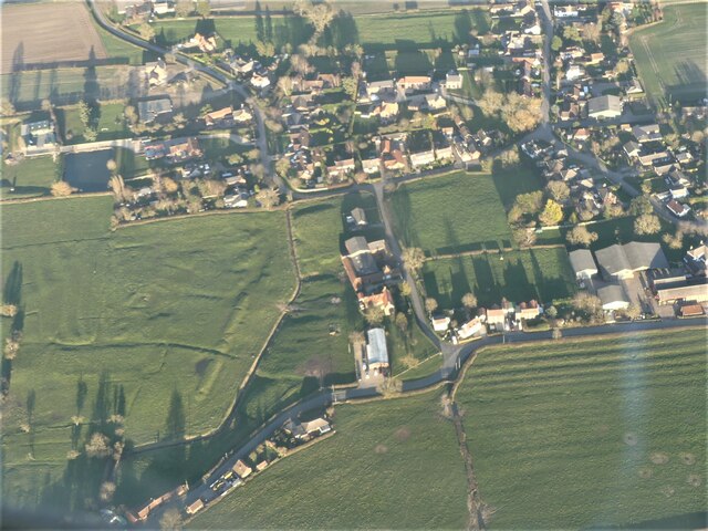
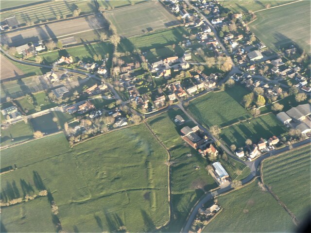
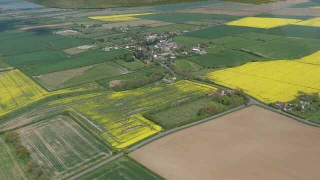
Yarburgh is a civil parish located in the East Lindsey district of Lincolnshire, England. Situated approximately 6 miles north-east of the town of Louth, it covers an area of about 5 square miles. The parish is predominantly rural, characterized by its picturesque countryside and rolling hills.

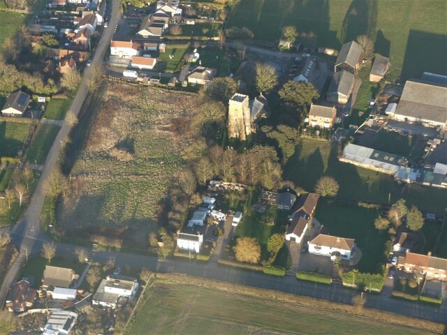
The village of Yarburgh itself is small, with a population of around 120 people. It is known for its charming and historic architecture, including the Grade I listed St. John the Baptist Church, which dates back to the 12th century. The church boasts a notable Norman tower and several intriguing medieval features.

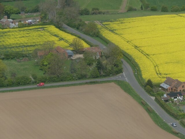
Yarburgh is surrounded by fertile agricultural land, with farming being a significant economic activity in the area. The landscape is dotted with farms and fields, creating a tranquil and idyllic atmosphere. The parish is also crisscrossed by a network of footpaths and bridleways, making it a popular destination for walkers and nature enthusiasts.

Although Yarburgh is primarily a residential and agricultural area, it benefits from its proximity to nearby towns and villages. The market town of Louth offers a range of amenities, including shops, schools, and healthcare facilities. Additionally, the coastal resorts of Cleethorpes and Mablethorpe are within easy reach, providing opportunities for leisure and tourism activities.

Overall, Yarburgh is a peaceful and picturesque civil parish in Lincolnshire, offering a close-knit community, stunning natural scenery, and easy access to nearby towns and the coast.

If you have any feedback on the listing, please let us know in the comments section below.

Yarburgh Images

Images are sourced within 2km of 53.418442/0.033776 or Grid Reference TF3593. Thanks to Geograph Open Source API. All images are credited.

Cropmark of moated site in field at Yarburgh: aerial 2021 (1) Showing up well as a positive cropmark, believed site of a Grange of Alvingham Priory.

See: <span class="nowrap"><a title="https://www.heritagegateway.org.uk/Gateway/Results_Single.aspx?uid=MLI41250&resourceID=1006" rel="nofollow ugc noopener" href="https://www.heritagegateway.org.uk/Gateway/Results_Single.aspx?uid=MLI41250&resourceID=1006">Link</a><img style="margin-left:2px;" alt="External link" title="External link - shift click to open in new window" src="https://s1.geograph.org.uk/img/external.png" width="10" height="10"/></span> and <a href="https://www.geograph.org.uk/photo/4858171">TF3593 : Yarburgh and cropmarks: aerial 2006</a>.
Cropmark of moated site in field at Yarburgh: aerial 2021 (1)
Showing up well as a positive cropmark, believed site of a Grange of Alvingham Priory. See: LinkExternal link and TF3593 : Yarburgh and cropmarks: aerial 2006.
Cropmark of moated site in field at Yarburgh: aerial 2021 (2) Showing up well as a positive cropmark, believed site of a Grange of Alvingham Priory.

See: <span class="nowrap"><a title="https://www.heritagegateway.org.uk/Gateway/Results_Single.aspx?uid=MLI41250&resourceID=1006" rel="nofollow ugc noopener" href="https://www.heritagegateway.org.uk/Gateway/Results_Single.aspx?uid=MLI41250&resourceID=1006">Link</a><img style="margin-left:2px;" alt="External link" title="External link - shift click to open in new window" src="https://s1.geograph.org.uk/img/external.png" width="10" height="10"/></span> and <a href="https://www.geograph.org.uk/photo/4858171">TF3593 : Yarburgh and cropmarks: aerial 2006</a>.
Cropmark of moated site in field at Yarburgh: aerial 2021 (2)
Showing up well as a positive cropmark, believed site of a Grange of Alvingham Priory. See: LinkExternal link and TF3593 : Yarburgh and cropmarks: aerial 2006.
Soilmarks on field at Yarburgh: aerial 2022
Ridge and furrow at Covenham St. Mary: aerial 2022
Mound in field south of Covenham St. Mary: aerial 2022 Listed as a prehistoric barrow: <span class="nowrap"><a title="https://www.heritagegateway.org.uk/Gateway/Results_Single.aspx?uid=MLI87809&resourceID=1006" rel="nofollow ugc noopener" href="https://www.heritagegateway.org.uk/Gateway/Results_Single.aspx?uid=MLI87809&resourceID=1006">Link</a><img style="margin-left:2px;" alt="External link" title="External link - shift click to open in new window" src="https://s1.geograph.org.uk/img/external.png" width="10" height="10"/></span>

Surrounded by ridge and furrow.
Mound in field south of Covenham St. Mary: aerial 2022
Listed as a prehistoric barrow: LinkExternal link Surrounded by ridge and furrow.
Alvingham: aerial 2022 (1)  Extensive earthworks have been noted in and around the village of Alvingham. Evidence for tofts, crofts and strip fields seen from aerial photographs spreading out from present village area.

See: <span class="nowrap"><a title="https://www.heritagegateway.org.uk/Gateway/Results_Single.aspx?uid=MLI41254&resourceID=1006" rel="nofollow ugc noopener" href="https://www.heritagegateway.org.uk/Gateway/Results_Single.aspx?uid=MLI41254&resourceID=1006">Link</a><img style="margin-left:2px;" alt="External link" title="External link - shift click to open in new window" src="https://s1.geograph.org.uk/img/external.png" width="10" height="10"/></span>
Alvingham: aerial 2022 (1)
Extensive earthworks have been noted in and around the village of Alvingham. Evidence for tofts, crofts and strip fields seen from aerial photographs spreading out from present village area. See: LinkExternal link
Alvingham: aerial 2022 Extensive earthworks have been noted in and around the village of Alvingham. Evidence for tofts, crofts and strip fields seen from aerial photographs spreading out from present village area.

See: <span class="nowrap"><a title="https://www.heritagegateway.org.uk/Gateway/Results_Single.aspx?uid=MLI41254&resourceID=1006" rel="nofollow ugc noopener" href="https://www.heritagegateway.org.uk/Gateway/Results_Single.aspx?uid=MLI41254&resourceID=1006">Link</a><img style="margin-left:2px;" alt="External link" title="External link - shift click to open in new window" src="https://s1.geograph.org.uk/img/external.png" width="10" height="10"/></span>
Alvingham: aerial 2022
Extensive earthworks have been noted in and around the village of Alvingham. Evidence for tofts, crofts and strip fields seen from aerial photographs spreading out from present village area. See: LinkExternal link
Yarburgh church and village: aerial 2022
Corner of Westfield Road, Yarburgh: aerial 2022
Yarburgh: aerial 2022 (1)
Fields near Covenham St Mary
Main Road over Poulton Drain The church is on the right.
Main Road over Poulton Drain
The church is on the right.
St Mary's church, Covenham St Mary The church stands surrounded by trees near the road.
St Mary's church, Covenham St Mary
The church stands surrounded by trees near the road.
Interior, St Mary's church, Covenham St Mary Grade II* listed

The church dates from mid 14th C. onwards.
There is a West tower, nave, chancel, and south porch.

The tower is 15th C. with an embattled parapet and pinnacles.
The Chancel was licensed in 1359.
Nave  and chancel roofs are 19th C. timber barrel vaulted. The nave walls have wooden panelling.
There is an Easter sepulchre or tomb arch in the north chancel wall.

The 15th C. Font is decorated with shields featuring instruments of the passion.

There are no Stained glass windows.
Interior, St Mary's church, Covenham St Mary
Grade II* listed The church dates from mid 14th C. onwards. There is a West tower, nave, chancel, and south porch. The tower is 15th C. with an embattled parapet and pinnacles. The Chancel was licensed in 1359. Nave and chancel roofs are 19th C. timber barrel vaulted. The nave walls have wooden panelling. There is an Easter sepulchre or tomb arch in the north chancel wall. The 15th C. Font is decorated with shields featuring instruments of the passion. There are no Stained glass windows.
Font, St Mary's church, Covenham St Mary One of the more interesting features of this rather dull church.
Font, St Mary's church, Covenham St Mary
One of the more interesting features of this rather dull church.
Grotesque corbel, St Mary's church, Covenham St Mary Grade II* listed

The church dates from mid 14th C. onwards.
There is a West tower, nave, chancel, and south porch.

The tower is 15th C. with an embattled parapet and pinnacles.
The Chancel was licensed in 1359.
Nave  and chancel roofs are 19th C. timber barrel vaulted. The nave walls have wooden panelling.
There is an Easter sepulchre or tomb arch in the north chancel wall.

The 15th C. Font is decorated with shields featuring instruments of the passion.

There are no Stained glass windows.
Grotesque corbel, St Mary's church, Covenham St Mary
Grade II* listed The church dates from mid 14th C. onwards. There is a West tower, nave, chancel, and south porch. The tower is 15th C. with an embattled parapet and pinnacles. The Chancel was licensed in 1359. Nave and chancel roofs are 19th C. timber barrel vaulted. The nave walls have wooden panelling. There is an Easter sepulchre or tomb arch in the north chancel wall. The 15th C. Font is decorated with shields featuring instruments of the passion. There are no Stained glass windows.
St Bartholomew's church, Covenham St Bartholomew View from the south east.
St Bartholomew's church, Covenham St Bartholomew
View from the south east.
St Bartholomew's church, Covenham St Bartholomew From the south west.
St Bartholomew's church, Covenham St Bartholomew
From the south west.
Show me another place!

Yarburgh is located at Grid Ref: TF3593 (Lat: 53.418442, Lng: 0.033776)

Administrative County: Lincolnshire

District: East Lindsey

Police Authority: Lincolnshire

What 3 Words

///rise.unloading.spell. Near Louth, Lincolnshire

Nearby Locations

Yarburgh

Related Wikis

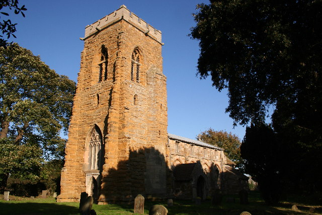
St John the Baptist's Church, Yarburgh

St John the Baptist's Church is a redundant Anglican church in the village of Yarburgh, Lincolnshire, England. It is recorded in the National Heritage...

Yarburgh

Yarburgh is a village and civil parish in the East Lindsey district of Lincolnshire, England, and situated approximately 4 miles (6 km) north-east from...

Alvingham

Alvingham is a village and civil parish in the East Lindsey district of Lincolnshire, England. It is situated 3 miles (5 km) north-east from the market...

Covenham St Bartholomew

Covenham St Bartholomew is a village in the East Lindsey district of Lincolnshire, England. It is situated approximately 5 miles (8 km) north from Louth...

Nearby Amenities

Located within 500m of 53.418442,0.033776
Yarburgh
Is In: Lincolnshire, England, UK
Place: hamlet
Source: npe
Lat/Long: 53.4170967/0.0306739
Bus Stop
Village Hall
Naptan AtcoCode: 270000009940
Naptan Bearing: NW
Naptan CommonName: Village Hall
Naptan Indicator: adj
Naptan Landmark: Village Hall
Naptan NaptanCode: linjgjpd
Naptan Street: Yarburgh
Naptan Verified: no
Source: naptan_import
Lat/Long: 53.4171779/0.0294839
Bus Stop
Village Hall
Naptan AtcoCode: 2700LY001908
Naptan Bearing: SE
Naptan CommonName: Village Hall
Naptan Indicator: opp
Naptan Landmark: Village Hall
Naptan NaptanCode: linamwgp
Naptan Street: Yarburgh
Naptan Verified: no
Source: naptan_import
Lat/Long: 53.4172388/0.0296072
Glebe Farm
Place: farm
Source: Bing
Lat/Long: 53.4167148/0.0322234
Ivy House Farm
Place: farm
Source: Bing
Lat/Long: 53.4158419/0.0327526
Model Farm
Place: farm
Source: Bing
Lat/Long: 53.4187467/0.0329988
Poultry Farm
Place: farm
Source: Bing
Lat/Long: 53.4199057/0.0371467
Generator Method: photovoltaic
Generator Output Electricity: yes
Generator Source: solar
Generator Type: solar_photovoltaic_panel
Location: roof
Power: generator
Lat/Long: 53.4179859/0.0324801
Generator Method: photovoltaic
Generator Output Electricity: yes
Generator Source: solar
Generator Type: solar_photovoltaic_panel
Location: roof
Power: generator
Lat/Long: 53.4179635/0.032405
Generator Method: photovoltaic
Generator Output Electricity: yes
Generator Source: solar
Generator Type: solar_photovoltaic_panel
Location: roof
Power: generator
Lat/Long: 53.4179939/0.0305945
Post Box
Collection Times: Mo-Fr 09:00; Sa 07:00
Operator: Royal Mail
Operator Wikidata: Q638098
Ref: LN11 68
Lat/Long: 53.4162899/0.0301272
Bench
Backrest: yes
Lat/Long: 53.4172299/0.0296459
The data included in this document is from www.openstreetmap.org. The data is made available under ODbL.

Have you been to Yarburgh?

Leave your review of Yarburgh below (or comments, questions and feedback).