Allaston

Settlement in Gloucestershire Forest of Dean

England

Allaston

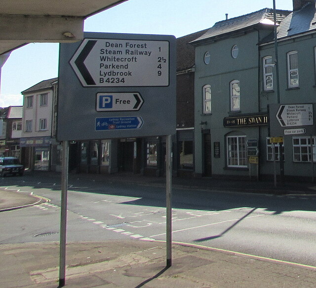
Directions sign, Hill Street, Lydney On a lamppost on the approach to the B4234 for Whitecroft and Parkend.
Directions sign, Hill Street, Lydney Credit: Jaggery

Allaston is a small village located in the county of Gloucestershire, England. Situated approximately 4 miles southeast of the town of Thornbury, Allaston is nestled in the picturesque countryside of the South West region. The village is part of the Thornbury Rural ward.

Allaston is a quintessential English village with a tranquil and rural atmosphere. It is known for its charming cottages, many of which date back to the 17th and 18th centuries, adding to the village's historical character. The surrounding landscape boasts rolling green hills, meadows, and scenic woodland, making it a perfect destination for nature lovers and outdoor enthusiasts.

The population of Allaston is relatively small, with around 200 residents. The village does not have its own school or post office, but amenities such as shops, schools, and healthcare facilities can be found in nearby Thornbury. Allaston is primarily a residential area, offering a peaceful and close-knit community for its residents.

Despite its small size, Allaston is not devoid of attractions. The village is conveniently located near the famous Berkeley Castle, a medieval fortress that offers guided tours and hosts various events throughout the year. Additionally, the nearby Thornbury Golf Centre provides opportunities for golf enthusiasts.

Allaston embodies the charm of rural England, offering a serene and idyllic setting for those seeking a peaceful retreat while still being within reach of larger towns and cities.

If you have any feedback on the listing, please let us know in the comments section below.

Allaston Images

Images are sourced within 2km of 51.732145/-2.524875 or Grid Reference SO6303. Thanks to Geograph Open Source API. All images are credited.

Directions sign, Hill Street, Lydney On a lamppost on the approach to the B4234 for Whitecroft and Parkend.
Directions sign, Hill Street, Lydney
On a lamppost on the approach to the B4234 for Whitecroft and Parkend.
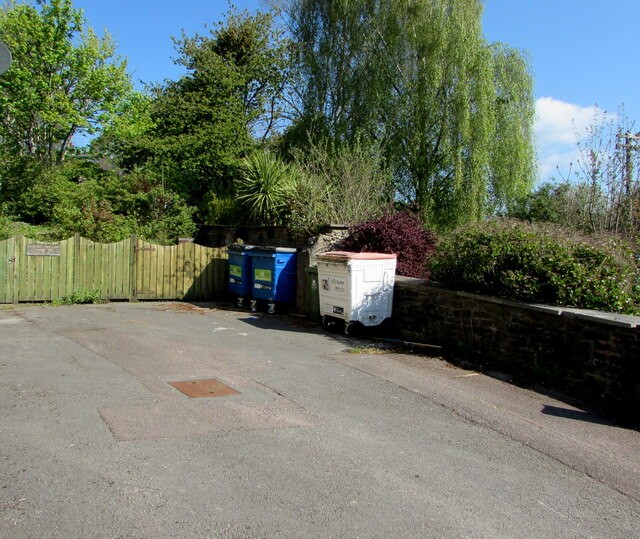
Suez wheelie bins, Lydney Large wheelie bins near the corner of Hill Street and Hill View in May 2021.
Suez wheelie bins, Lydney
Large wheelie bins near the corner of Hill Street and Hill View in May 2021.
Up Hill View, Lydney Dead-end Hill View ascends from Hill Street.
Up Hill View, Lydney
Dead-end Hill View ascends from Hill Street.
Warning sign alongside Hill Street, Lydney Showing Patrol 85yds. The car is turning into Bathurst Park Road in May 2021.
Warning sign alongside Hill Street, Lydney
Showing Patrol 85yds. The car is turning into Bathurst Park Road in May 2021.
Single-track railway in Lydney This part of the heritage Dean Forest Railway is past the edge of Town Station Business Park.
Single-track railway in Lydney
This part of the heritage Dean Forest Railway is past the edge of Town Station Business Park.
Town Station Business Park access road, Lydney On the north side of Hill Street.
Town Station Business Park access road, Lydney
On the north side of Hill Street.
Thank You to our NHS workers and all key workers, Lydney Alongside Town Station Business Park access road in May 2021 during the Coronavirus (COVID-19) pandemic.
Thank You to our NHS workers and all key workers, Lydney
Alongside Town Station Business Park access road in May 2021 during the Coronavirus (COVID-19) pandemic.
Town Station Business Park name sign, Lydney In the background here <a title="https://www.geograph.org.uk/photo/6983679" href="https://www.geograph.org.uk/photo/6983679">Link</a> in May 2021. Also shown are a Lydney Space Station sign and a Velux sign. The rusty railings on the left are at the edge of the heritage Dean Forest Railway. <a title="https://www.geograph.org.uk/photo/6983653" href="https://www.geograph.org.uk/photo/6983653">Link</a>
Town Station Business Park name sign, Lydney
In the background here Link in May 2021. Also shown are a Lydney Space Station sign and a Velux sign. The rusty railings on the left are at the edge of the heritage Dean Forest Railway. Link
Dominant trees in Lydney Viewed across Hill Street.
Dominant trees in Lydney
Viewed across Hill Street.
SSE along Bathurst Park Road, Lydney From Hill Street, Bathurst Park Road leads to Bathurst Park. 
Formerly Lydney Police Station, the building on the corner is now (2021) in business use.
SSE along Bathurst Park Road, Lydney
From Hill Street, Bathurst Park Road leads to Bathurst Park. Formerly Lydney Police Station, the building on the corner is now (2021) in business use.
Stay Safe, Shop Local, Lydney On a Hill Street lamppost in May 2021 during the Coronavirus (COVID-19) pandemic.
Stay Safe, Shop Local, Lydney
On a Hill Street lamppost in May 2021 during the Coronavirus (COVID-19) pandemic.
Windows on the west side of Watney Hall, Lydney The name sign shows WATNEY HALL AT 3 HILL STREET.
Windows on the west side of Watney Hall, Lydney
The name sign shows WATNEY HALL AT 3 HILL STREET.
Sorry We Are Closed, Watney Hall, Lydney The notice is at the entrance to Watney Hall at 3 Hill Street in May 2021 during the Coronavirus (COVID-19) pandemic. It shows 

SORRY WE ARE CLOSED. 

We did try to open but we completely understand why some customers do not feel comfortable and it was difficult to socialise in the safe environment that we have created.

We will keep the matter under review in line with the regulations, but we do not expect to reopen until at least October.
Sorry We Are Closed, Watney Hall, Lydney
The notice is at the entrance to Watney Hall at 3 Hill Street in May 2021 during the Coronavirus (COVID-19) pandemic. It shows SORRY WE ARE CLOSED. We did try to open but we completely understand why some customers do not feel comfortable and it was difficult to socialise in the safe environment that we have created. We will keep the matter under review in line with the regulations, but we do not expect to reopen until at least October.
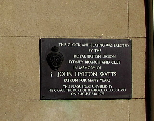
Plaque dated 1973, Hill Street, Lydney The plaque on the wall of 3 Hill Street <a title="https://www.geograph.org.uk/photo/3805239" href="https://www.geograph.org.uk/photo/3805239">Link</a> shows THIS CLOCK AND SEATING WAS ERECTED BY THE ROYAL BRITISH LEGION LYDNEY BRANCH AND CLUB IN MEMORY OF JOHN HYLTON WATTS PATRON FOR MANY YEARS. THIS PLAQUE WAS UNVEILED BY HIS GRACE THE DUKE OF BEAUFORT K.G. P.C. G.C.V.O. ON AUGUST 5TH 1973.
Plaque dated 1973, Hill Street, Lydney
The plaque on the wall of 3 Hill Street Link shows THIS CLOCK AND SEATING WAS ERECTED BY THE ROYAL BRITISH LEGION LYDNEY BRANCH AND CLUB IN MEMORY OF JOHN HYLTON WATTS PATRON FOR MANY YEARS. THIS PLAQUE WAS UNVEILED BY HIS GRACE THE DUKE OF BEAUFORT K.G. P.C. G.C.V.O. ON AUGUST 5TH 1973.
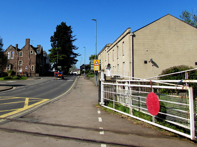
Level crossing gate, Hill Street, Lydney In the foreground the track of the Dean Forest Railway crosses Hill Street.
Level crossing gate, Hill Street, Lydney
In the foreground the track of the Dean Forest Railway crosses Hill Street.
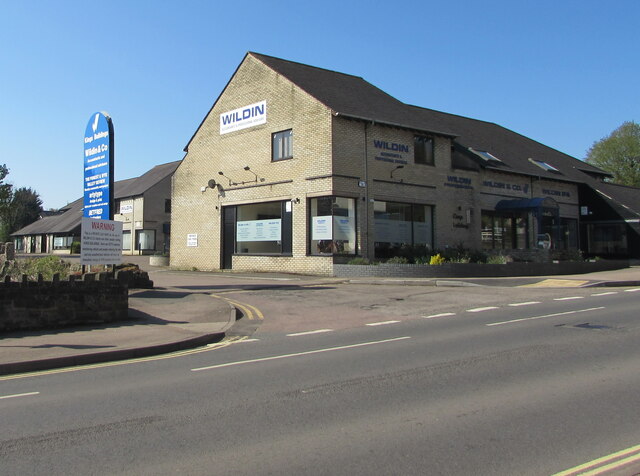
Wildin & Co, Hill Street, Lydney Accountants offices in King's Buildings.
Wildin & Co, Hill Street, Lydney
Accountants offices in King's Buildings.
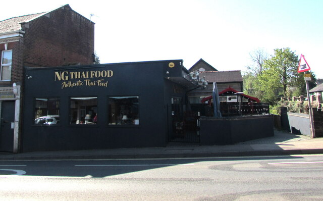
NG Thai Food, 18 Hill Street, Lydney On the right here. <a title="https://www.geograph.org.uk/photo/6869015" href="https://www.geograph.org.uk/photo/6869015">Link</a>
NG Thai Food, 18 Hill Street, Lydney
On the right here. Link
B4234 direction and distances sign, Hill Street, Lydney Turn left here into the B4234 Forest Road for the Dean Forest Steam railway (1 mile), Whitecroft (2½), Parkend (4), Lydbrook (9).
B4234 direction and distances sign, Hill Street, Lydney
Turn left here into the B4234 Forest Road for the Dean Forest Steam railway (1 mile), Whitecroft (2½), Parkend (4), Lydbrook (9).
Show me another place!

Allaston is located at Grid Ref: SO6303 (Lat: 51.732145, Lng: -2.524875)

Administrative County: Gloucestershire

District: Forest of Dean

Police Authority: Gloucestershire

What 3 Words

///dodging.impresses.composes. Near Lydney, Gloucestershire

Related Wikis

Nearby Amenities

Located within 500m of 51.732145,-2.524875
Bus Stop
Augustus Way
Naptan AtcoCode: 1600GL3122
Naptan Bearing: E
Naptan CommonName: Augustus Way
Naptan NaptanCode: gloajajt
Naptan Street: Centurion Rd
Naptan Verified: no
Source: naptan_import
Lat/Long: 51.7327227/-2.523947
Bus Stop
Post Office
Naptan AtcoCode: 1600GL3897
Naptan Bearing: N
Naptan CommonName: Post Office
Naptan NaptanCode: gloagwda
Naptan Street: Primrose Hill Rd
Naptan Verified: no
Source: naptan_import
Lat/Long: 51.7339871/-2.5307243
Bus Stop
Post Office
Naptan AtcoCode: 1600GL3898
Naptan Bearing: S
Naptan CommonName: Post Office
Naptan Indicator: Opp
Naptan NaptanCode: gloagwdp
Naptan Street: Primrose Hill Rd
Naptan Verified: no
Source: naptan_import
Lat/Long: 51.7338438/-2.5305923
Bus Stop
Almond Walk
Naptan AtcoCode: 1600GL3901
Naptan Bearing: N
Naptan CommonName: Almond Walk
Naptan Indicator: Opp
Naptan NaptanCode: gloagwjw
Naptan Street: Primrose Way
Naptan Verified: no
Source: naptan_import
Lat/Long: 51.7326565/-2.5287104
Bus Stop
Almond Walk
Naptan AtcoCode: 1600GL3902
Naptan Bearing: S
Naptan CommonName: Almond Walk
Naptan NaptanCode: gloagwma
Naptan Street: Primrose Way
Naptan Verified: no
Source: naptan_import
Lat/Long: 51.7327019/-2.5285951
Bus Stop
Lancaster Drive
Naptan AtcoCode: 1600GL3903
Naptan Bearing: W
Naptan CommonName: Lancaster Drive
Naptan Indicator: Opp
Naptan NaptanCode: gloagwjd
Naptan Street: Primrose Way
Naptan Verified: no
Source: naptan_import
Lat/Long: 51.7342731/-2.5291202
Bus Stop
Lancaster Drive
Naptan AtcoCode: 1600GL3904
Naptan Bearing: E
Naptan CommonName: Lancaster Drive
Naptan NaptanCode: gloagwjg
Naptan Street: Primrose Way
Naptan Verified: no
Source: naptan_import
Lat/Long: 51.7343633/-2.5290489
Bus Stop
Cherry Walk
Naptan AtcoCode: 1600GL5323
Naptan Bearing: NE
Naptan CommonName: Cherry Walk
Naptan NaptanCode: gloagwgp
Naptan Street: Woodland Rise
Naptan Verified: no
Source: naptan_import
Lat/Long: 51.731161/-2.529359
Bus Stop
Cherry Walk
Naptan AtcoCode: 1600GL5324
Naptan Bearing: SW
Naptan BusStopType: CUS
Naptan CommonName: Cherry Walk
Naptan Indicator: Opp
Naptan NaptanCode: gloagwgt
Naptan Street: Woodland Rise
Naptan Verified: no
Source: naptan_import
Lat/Long: 51.731071/-2.529358
Bus Stop
Centurion Road
Naptan AtcoCode: 1600GLF229
Naptan Bearing: SW
Naptan CommonName: Centurion Road
Naptan NaptanCode: gloajdap
Naptan Street: Highfield Rd
Naptan Verified: no
Source: naptan_import
Lat/Long: 51.7322281/-2.5199303
Bus Stop
Cross Hands
Naptan AtcoCode: 1600GLF230
Naptan Bearing: NE
Naptan CommonName: Cross Hands
Naptan NaptanCode: gloajawp
Naptan Street: Highfield Rd
Naptan Verified: no
Source: naptan_import
Lat/Long: 51.7328614/-2.5190397
Bus Stop
Kimberley Drive
Naptan AtcoCode: 1600GLF231
Naptan Bearing: SW
Naptan CommonName: Kimberley Drive
Naptan NaptanCode: gloajagt
Naptan Street: Highfield Rd
Naptan Verified: no
Shelter: no
Source: naptan_import
Lat/Long: 51.7306315/-2.523112
Bus Stop
Kimberley Drive
Naptan AtcoCode: 1600GLF232
Naptan Bearing: NE
Naptan CommonName: Kimberley Drive
Naptan Indicator: Opp
Naptan NaptanCode: gloajagw
Naptan Street: Highfield Rd
Naptan Verified: no
Source: naptan_import
Lat/Long: 51.7302406/-2.5240631
Bus Stop
Car Park
Naptan AtcoCode: 1600GLF333
Naptan Bearing: NW
Naptan CommonName: Car Park
Naptan NaptanCode: gloagwmd
Naptan Street: Albert St
Naptan Verified: no
Source: naptan_import
Lat/Long: 51.7282342/-2.5283692
Bus Stop
Livia Way
Naptan AtcoCode: 1600GLF349
Naptan Bearing: W
Naptan BusStopType: CUS
Naptan CommonName: Livia Way
Naptan Indicator: Opp
Naptan NaptanCode: gloagwtj
Naptan Street: Centurion Rd
Naptan Verified: no
Source: naptan_import
Lat/Long: 51.7324992/-2.5256821
Bus Stop
Livia Way
Naptan AtcoCode: 1600GLF350
Naptan Bearing: E
Naptan CommonName: Livia Way
Naptan NaptanCode: gloagwtg
Naptan Street: Centurion Rd
Naptan Verified: no
Source: naptan_import
Lat/Long: 51.7326306/-2.5264511
Bus Stop
Beauchamp Meadow
Naptan AtcoCode: 1600GLF351
Naptan Bearing: NW
Naptan CommonName: Beauchamp Meadow
Naptan Indicator: Opp
Naptan NaptanCode: gloajapt
Naptan Street: Centurion Rd
Naptan Verified: no
Source: naptan_import
Lat/Long: 51.7327467/-2.5205734
Bus Stop
Beauchamp Meadow
Naptan AtcoCode: 1600GLF352
Naptan Bearing: SE
Naptan CommonName: Beauchamp Meadow
Naptan NaptanCode: gloajapw
Naptan Street: Centurion Rd
Naptan Verified: no
Source: naptan_import
Lat/Long: 51.7327029/-2.5203122
Bus Stop
Kimberley Close
Naptan AtcoCode: 1600GLF355
Naptan Bearing: SW
Naptan CommonName: Kimberley Close
Naptan Indicator: Opp
Naptan NaptanCode: gloajajm
Naptan Street: Kimberley Drive
Naptan Verified: no
Source: naptan_import
Lat/Long: 51.7283191/-2.5234618
Bus Stop
Springfield Methodist Church
Naptan AtcoCode: 1600GLF703
Naptan Bearing: NW
Naptan CommonName: Springfield Methodist Church
Naptan NaptanCode: gloagwga
Naptan Street: Albert St
Naptan Verified: no
Source: naptan_import
Lat/Long: 51.7297263/-2.5304717
Bus Stop
Springfield Methodist Church
Naptan AtcoCode: 1600GLF704
Naptan Bearing: SE
Naptan CommonName: Springfield Methodist Church
Naptan Indicator: Opp
Naptan NaptanCode: gloagwgd
Naptan Street: Albert St
Naptan Verified: no
Source: naptan_import
Lat/Long: 51.7297453/-2.5302402
Place Of Worship
Springfield Methodist Church
Denomination: methodist
Religion: christian
Source: NPE + NaPTAN
Lat/Long: 51.729746/-2.5307928
Bus Stop
Car Park
Bus: yes
Naptan AtcoCode: 1600GLF334
Naptan Bearing: SE
Naptan CommonName: Car Park
Naptan Indicator: opp
Naptan NaptanCode: gloagwmw
Naptan Street: Albert Street
Naptan Verified: no
Public Transport: platform
Lat/Long: 51.7282568/-2.5281168
Traffic Signals
Lat/Long: 51.7328739/-2.518815
Primrose Hill
Place: locality
Source: OS_OpenData_StreetView
Lat/Long: 51.7330725/-2.5315446
Leisure: playground
Lat/Long: 51.7323308/-2.5320165
Bench
Backrest: yes
Lat/Long: 51.7320223/-2.5316718
The data included in this document is from www.openstreetmap.org. The data is made available under ODbL.

Have you been to Allaston?

Leave your review of Allaston below (or comments, questions and feedback).