Steeple with Tyneham

Civil Parish in Dorset Purbeck

England

Steeple with Tyneham

View northeast along the ridge from Tyneham Cap This path is one of the Range Walks, descending along the Purbeck limestone ridge from the heights of Tyneham Cap. In the distance are the Purbeck Hills, a chalk ridge that runs parallel to, and to the north of, the limestone ridge. The notch in the chalk ridge is at Corfe Castle, where the Corfe River cuts through on its way to Poole Harbour.
View northeast along the ridge from Tyneham Cap Credit: Jim Champion

Steeple with Tyneham is a civil parish located in the county of Dorset, England. It is situated within the Isle of Purbeck, an area known for its scenic beauty and rich history. The parish covers an area of approximately 15 square kilometers and is home to a small population.

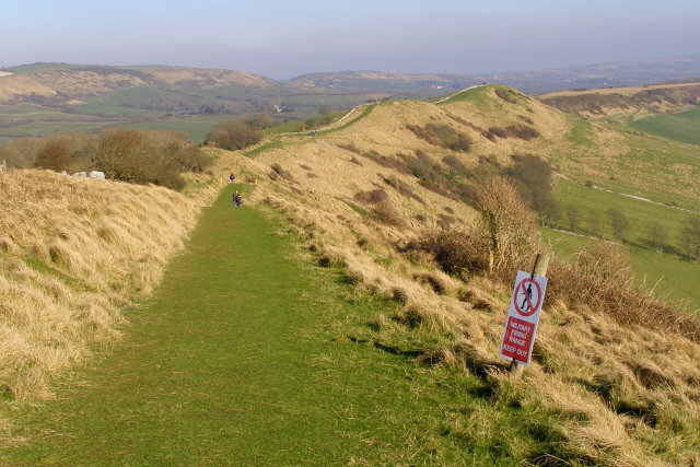
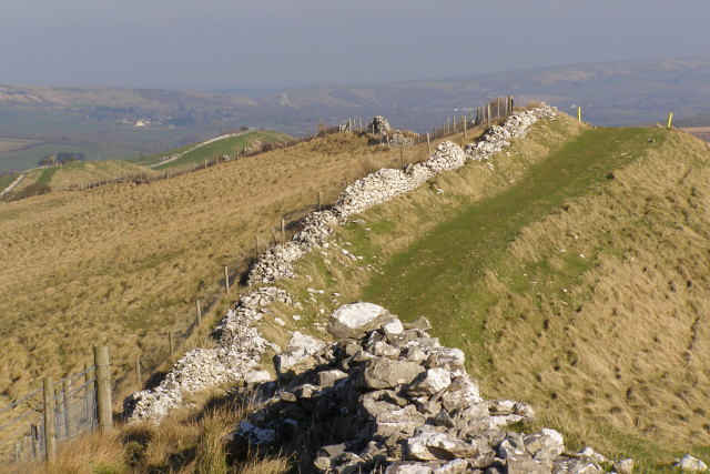
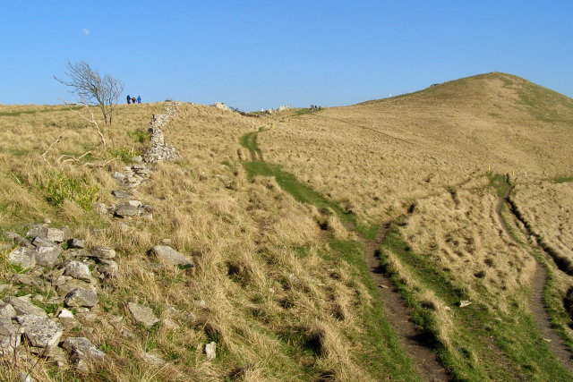
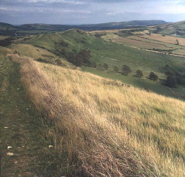
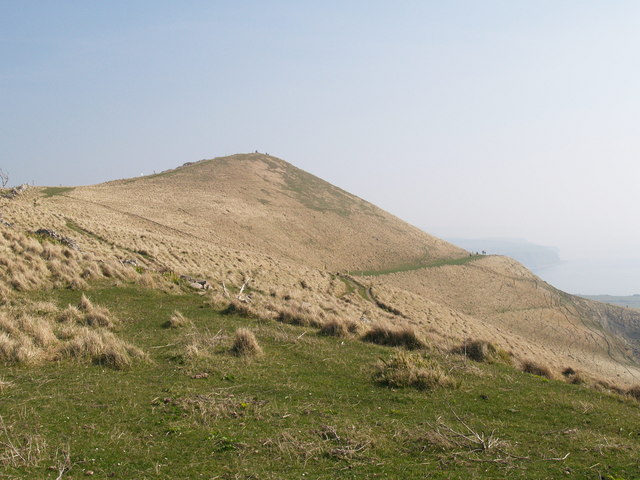
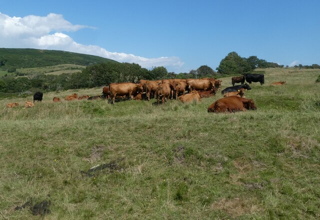
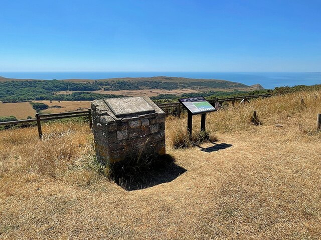
Steeple with Tyneham is characterized by its picturesque countryside, rolling hills, and charming rural villages. The parish is renowned for its natural beauty, with stunning landscapes that attract visitors and nature enthusiasts alike. Many visitors come to explore the nearby chalk downs and coastal areas, which offer breathtaking views and a diverse range of flora and fauna.

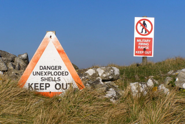
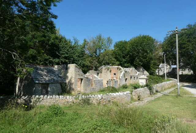
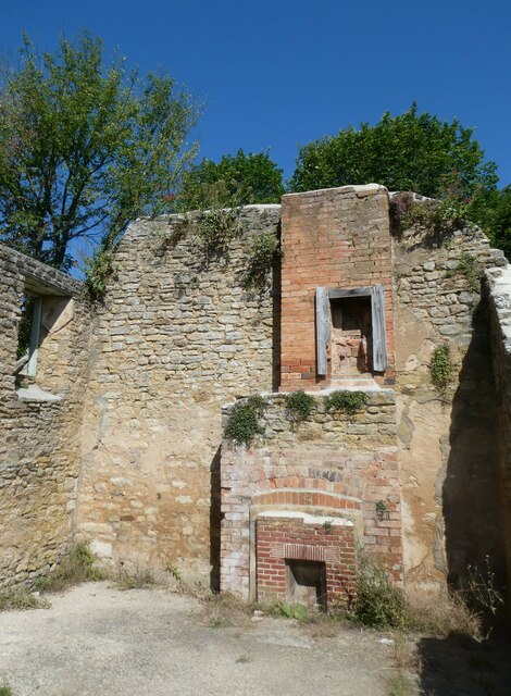
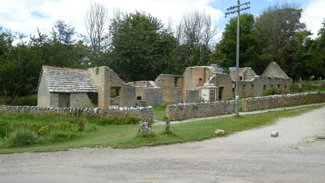
One of the notable features of Steeple with Tyneham is the abandoned village of Tyneham. During World War II, the village was evacuated by the military in order to use the land as a training ground. Although the villagers were promised that they could return after the war, the village remained deserted and has since become a poignant reminder of the impact of war on rural communities. Today, the village is maintained by the Ministry of Defence and is open to the public on specified days, allowing visitors to explore the preserved houses and gain insight into the lives of the former residents.

Steeple with Tyneham offers a tranquil and idyllic setting, with its unspoiled landscapes and historic village. It is a place where visitors can immerse themselves in nature and experience a glimpse of the past, making it a popular destination for those seeking a unique and authentic English countryside experience.

If you have any feedback on the listing, please let us know in the comments section below.

Steeple with Tyneham Images

Images are sourced within 2km of 50.635101/-2.149928 or Grid Reference SY8981. Thanks to Geograph Open Source API. All images are credited.

View northeast along the ridge from Tyneham Cap This path is one of the Range Walks, descending along the Purbeck limestone ridge from the heights of Tyneham Cap. In the distance are the Purbeck Hills, a chalk ridge that runs parallel to, and to the north of, the limestone ridge. The notch in the chalk ridge is at Corfe Castle, where the Corfe River cuts through on its way to Poole Harbour.
View northeast along the ridge from Tyneham Cap
This path is one of the Range Walks, descending along the Purbeck limestone ridge from the heights of Tyneham Cap. In the distance are the Purbeck Hills, a chalk ridge that runs parallel to, and to the north of, the limestone ridge. The notch in the chalk ridge is at Corfe Castle, where the Corfe River cuts through on its way to Poole Harbour.
View along the Ridge, Tyneham Cap This drystone wall follows the top of the Purbeck limestone ridge, with one of the Lulworth Range Walks following it on the southern (right) side. In the far distance is the Purbeck Hills chalk ridge, and the ruins of Corfe Castle are just about visible through the haze.
View along the Ridge, Tyneham Cap
This drystone wall follows the top of the Purbeck limestone ridge, with one of the Lulworth Range Walks following it on the southern (right) side. In the far distance is the Purbeck Hills chalk ridge, and the ruins of Corfe Castle are just about visible through the haze.
Warning signs, west of Tyneham Cap These warning signs are typical of those found throughout the Lulworth Range, alongside the waymarked Range Walks. Apparently there have been very few instances of civilians being injured by ordnance on the Lulworth range (something to do with fossil hunters in a quarry) - the Range Walks are checked for hazards by the MOD before they are opened to the public. The gunnery generally goes on to the north of the Purbeck chalk ridge, but there is danger of ricochet in this area to the south.
Warning signs, west of Tyneham Cap
These warning signs are typical of those found throughout the Lulworth Range, alongside the waymarked Range Walks. Apparently there have been very few instances of civilians being injured by ordnance on the Lulworth range (something to do with fossil hunters in a quarry) - the Range Walks are checked for hazards by the MOD before they are opened to the public. The gunnery generally goes on to the north of the Purbeck chalk ridge, but there is danger of ricochet in this area to the south.
Tyneham Cap from the west The Range Walk path splits here, with the left branch climbing up to Tyneham Cap (the pointy hill on the right) and the right branch continuing along the coast of Brandy Bay towards Broad Bench. The three figures on the left are likely to explode at any moment. Above the tree on the left is a waxing gibbous moon.
Tyneham Cap from the west
The Range Walk path splits here, with the left branch climbing up to Tyneham Cap (the pointy hill on the right) and the right branch continuing along the coast of Brandy Bay towards Broad Bench. The three figures on the left are likely to explode at any moment. Above the tree on the left is a waxing gibbous moon.
Ridge path above South Egliston Looking east along the path which follows the gentle curve of the Purbeck stone ridge above Kimmeridge village (just visible on the extreme right). The second curving ridge beyond this one is the Purbeck Hills chalk ridge, ending on the right at Brenscombe Hill and Nine Barrow Down above Corfe and Swanage.
Ridge path above South Egliston
Looking east along the path which follows the gentle curve of the Purbeck stone ridge above Kimmeridge village (just visible on the extreme right). The second curving ridge beyond this one is the Purbeck Hills chalk ridge, ending on the right at Brenscombe Hill and Nine Barrow Down above Corfe and Swanage.
Tyneham Cap
Tyneham Cap
Cows resting at Tyneham Farm
Approaching the lost village of Tyneham
Inside the shepherd's cottage at Tyneham
Rectory Cottages, Tyneham In the first half of the twentieth century, Tyneham would have been an idyllic countryside village, only a couple of miles from the sea and the delightful Worbarrow Bay.  

All changed towards the end of 1943, when the village of Tyneham and 7,500 acres of surrounding heathland and chalk downland were commandeered by the War Office, for use as firing ranges for training troops. Altogether, 252 people were displaced. The villagers were told that this measure was to be temporary for the duration of World War II, but in 1948 the army placed a compulsory purchase order on the land and it has remained in use for military training ever since. The villagers were not allowed to return to their homes, but were given new accommodation. 

The village of Tyenham has remained uninhabited for nearly seventy years.  In 1975, after complaints from tourists and locals, the Ministry of Defence began opening the village and footpaths across the ranges at weekends and throughout August. The church and school have been restored and act as a museum; many of the other buildings stand in various states of disrepair.

<span class="nowrap"><a title="http://www.tynehamopc.org.uk/tyneham_village.html" rel="nofollow ugc noopener" href="http://www.tynehamopc.org.uk/tyneham_village.html">Link</a><img style="margin-left:2px;" alt="External link" title="External link - shift click to open in new window" src="https://s1.geograph.org.uk/img/external.png" width="10" height="10"/></span> and <span class="nowrap"><a title="http://www.isleofpurbeck.com/tyneham.html" rel="nofollow ugc noopener" href="http://www.isleofpurbeck.com/tyneham.html">Link</a><img style="margin-left:2px;" alt="External link" title="External link - shift click to open in new window" src="https://s1.geograph.org.uk/img/external.png" width="10" height="10"/></span> for more details
Rectory Cottages, Tyneham
In the first half of the twentieth century, Tyneham would have been an idyllic countryside village, only a couple of miles from the sea and the delightful Worbarrow Bay. All changed towards the end of 1943, when the village of Tyneham and 7,500 acres of surrounding heathland and chalk downland were commandeered by the War Office, for use as firing ranges for training troops. Altogether, 252 people were displaced. The villagers were told that this measure was to be temporary for the duration of World War II, but in 1948 the army placed a compulsory purchase order on the land and it has remained in use for military training ever since. The villagers were not allowed to return to their homes, but were given new accommodation. The village of Tyenham has remained uninhabited for nearly seventy years. In 1975, after complaints from tourists and locals, the Ministry of Defence began opening the village and footpaths across the ranges at weekends and throughout August. The church and school have been restored and act as a museum; many of the other buildings stand in various states of disrepair. LinkExternal link and LinkExternal link for more details
View from the churchyard at Tyneham
Graves of The Rev Henry and Mrs Editha Bond Also see <span class="nowrap"><a title="http://www.thepeerage.com/p43150.htm#i431494" rel="nofollow ugc noopener" href="http://www.thepeerage.com/p43150.htm#i431494">Link</a><img style="margin-left:2px;" alt="External link" title="External link - shift click to open in new window" src="https://s1.geograph.org.uk/img/external.png" width="10" height="10"/></span> and <span class="nowrap"><a title="https://tynehamvillage.org/the-bond-family/" rel="nofollow ugc noopener" href="https://tynehamvillage.org/the-bond-family/">Link</a><img style="margin-left:2px;" alt="External link" title="External link - shift click to open in new window" src="https://s1.geograph.org.uk/img/external.png" width="10" height="10"/></span>
Graves of The Rev Henry and Mrs Editha Bond
Also see LinkExternal link and LinkExternal link
Information panel on Povington Hill Viewpoint overlooking Tyneham and the army training area
Information panel on Povington Hill
Viewpoint overlooking Tyneham and the army training area
Former church of St Mary The village of Tyneham was evacuated in 1943 when the surrounding land was required for military training in preparation for D-Day. Most of the buildings have fallen into disrepair but both the restored church and school building are still intact and house exhibitions about the village and villagers
Former church of St Mary
The village of Tyneham was evacuated in 1943 when the surrounding land was required for military training in preparation for D-Day. Most of the buildings have fallen into disrepair but both the restored church and school building are still intact and house exhibitions about the village and villagers
Tyneham telephone kiosk This public telephone kiosk was installed outside the Post Office, only a few weeks before the village was evacuated in 1943.
Tyneham telephone kiosk
This public telephone kiosk was installed outside the Post Office, only a few weeks before the village was evacuated in 1943.
Former schoolhouse The village of Tyneham was evacuated in 1943 when the surrounding land was required for military training in preparation for D-Day. Most of the buildings have fallen into disrepair but both the restored school and church building are still intact and house exhibitions about the village and villagers
Former schoolhouse
The village of Tyneham was evacuated in 1943 when the surrounding land was required for military training in preparation for D-Day. Most of the buildings have fallen into disrepair but both the restored school and church building are still intact and house exhibitions about the village and villagers
Abandoned cottages in The Row The village of Tyneham was evacuated in 1943 when the surrounding land was required for military training in preparation for D-Day. Most of the buildings have fallen into disrepair.
Abandoned cottages in The Row
The village of Tyneham was evacuated in 1943 when the surrounding land was required for military training in preparation for D-Day. Most of the buildings have fallen into disrepair.
Tyneham village Tyneham abandoned village, what remains of the village
Tyneham village
Tyneham abandoned village, what remains of the village
Show me another place!

Steeple with Tyneham is located at Grid Ref: SY8981 (Lat: 50.635101, Lng: -2.149928)

Administrative County: Dorset

District: Purbeck

Police Authority: Dorset

What 3 Words

///snowy.latched.linguists. Near Wareham, Dorset

Related Wikis

Povington Hill

Povington Hill, at 198 metres (650 ft) high, is one of the highest points on the chain of the Purbeck Hills in south Dorset on the southern coast of England...

Povington Priory

Povington Priory was a Benedictine priory in Tyneham, Dorset, England. It was established as an alien priory of the Abbey of Bec. This term could mean...

Lulworth Ranges

The Lulworth Ranges are military firing ranges located between Wareham and Lulworth in Dorset, England. They cover an area of more than 2,830 hectares...

Creech Grange

Creech Grange is a country house in Steeple, south of Wareham in Dorset at the foot of the Purbeck Hills. Historic England designate it as a Grade I listed...

Steeple, Dorset

Steeple is a hamlet and former civil parish, now in the civil parish of Steeple with Tyneham, in the Purbeck district of the English county of Dorset....

Grange Arch

Grange Arch, also known as Creech Folly, is an 18th-century folly that is located near the second highest point of the Purbeck Hills, Ridgeway Hill (199...

St Mary's Church, Tyneham

St Mary's Church is a former Church of England parish church in Tyneham, Dorset, England. The church, which is a Grade II listed building, has 13th-century...

Tyneham

Tyneham is a ghost village abandoned in 1943 and former civil parish, now in the parish of Steeple with Tyneham, in the Dorset district, in the south of...

Nearby Amenities

Located within 500m of 50.635101,-2.149928
West Creech Hill
Ele: 174
Natural: peak
Source: OS OpenData StreetView
Lat/Long: 50.6334489/-2.150212
Crossing: informal
Lat/Long: 50.6334278/-2.1493926
The data included in this document is from www.openstreetmap.org. The data is made available under ODbL.

Have you been to Steeple with Tyneham?

Leave your review of Steeple with Tyneham below (or comments, questions and feedback).