Shrewton
Civil Parish in Wiltshire
England
Shrewton

Shrewton is a civil parish located in the county of Wiltshire, England. It is situated approximately 9 miles north of Salisbury and covers an area of around 5.7 square miles. The village of Shrewton itself is small, with a population of just over 1,000 residents.
Shrewton is known for its picturesque countryside and rural charm, with rolling hills and farmland surrounding the village. The area is popular with hikers and nature enthusiasts, thanks to its proximity to the Salisbury Plain and the River Till.
The village has a few amenities, including a primary school, village hall, post office, and a handful of shops and pubs. The parish church, St. Mary's, is a notable landmark in the village and dates back to the 12th century.
Overall, Shrewton is a peaceful and idyllic village, offering a quiet and rural lifestyle for its residents. Its close proximity to Salisbury and the surrounding countryside make it a desirable location for those looking to escape the hustle and bustle of city life.
If you have any feedback on the listing, please let us know in the comments section below.
Shrewton Images
Images are sourced within 2km of 51.188536/-1.920553 or Grid Reference SU0543. Thanks to Geograph Open Source API. All images are credited.

![Orcheston houses [17] Almost hidden in the trees, Drax House, Whatcombe Brow, is a former farmhouse. Built in the mid 17th century in two phases, with an early 19th century rear extension. Constructed of flint and limestone, the extension in brick, all under tile roofs. Some original internal features and fittings remain. Listed, grade II, with details at: <span class="nowrap"><a title="https://historicengland.org.uk/listing/the-list/list-entry/1023981" rel="nofollow ugc noopener" href="https://historicengland.org.uk/listing/the-list/list-entry/1023981">Link</a><img style="margin-left:2px;" alt="External link" title="External link - shift click to open in new window" src="https://s1.geograph.org.uk/img/external.png" width="10" height="10"/></span>
The small village of Orcheston lies on Salisbury Plain about a mile northwest of Shrewton and some 6¼ miles west of Durrington. Salisbury plain has been inhabited since prehistoric times, and Orcheston is recorded in the 1086 Domesday Book. The source of the River Till is nearby. The village has two 13th century churches.](https://s1.geograph.org.uk/geophotos/07/37/97/7379769_f4973535.jpg)
![Orcheston buildings [2] Orcheston village hall, Whatcombe Brow, is not the most attractive building in the village.
The small village of Orcheston lies on Salisbury Plain about a mile northwest of Shrewton and some 6¼ miles west of Durrington. Salisbury plain has been inhabited since prehistoric times, and Orcheston is recorded in the 1086 Domesday Book. The source of the River Till is nearby. The village has two 13th century churches.](https://s2.geograph.org.uk/geophotos/07/37/97/7379778_a4030ee3.jpg)
![Orcheston houses [18] The Old Rectory is just visible behind the garden wall. Built in the 17th and 18th centuries, with alterations in the early and mid 19th century when the rear service wing was added. The main front is at right angles to the road and the service wing is now a separate dwelling. Constructed of brick with limestone quoins and some flint, all under a tile roof. Listed, grade II, with details at: <span class="nowrap"><a title="https://historicengland.org.uk/listing/the-list/list-entry/1023980" rel="nofollow ugc noopener" href="https://historicengland.org.uk/listing/the-list/list-entry/1023980">Link</a><img style="margin-left:2px;" alt="External link" title="External link - shift click to open in new window" src="https://s1.geograph.org.uk/img/external.png" width="10" height="10"/></span>
The small village of Orcheston lies on Salisbury Plain about a mile northwest of Shrewton and some 6¼ miles west of Durrington. Salisbury plain has been inhabited since prehistoric times, and Orcheston is recorded in the 1086 Domesday Book. The source of the River Till is nearby. The village has two 13th century churches.](https://s3.geograph.org.uk/geophotos/07/37/97/7379787_39fb7ede.jpg)
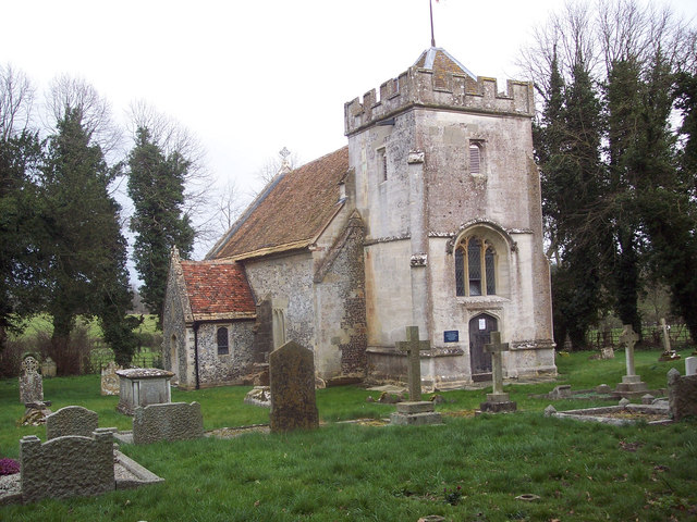
![Orcheston buildings [3] The former Anglican parish church of St George is now redundant and in the care of the Churches Conservation Trust. Built in the 13th century with a late 15th century chancel, the church was restored in 1833 and in 1858. Constructed of flint and limestone, the tower is of ashlar, all under a tile roof. Listed, grade II*, with details at: <span class="nowrap"><a title="https://historicengland.org.uk/listing/the-list/list-entry/1024021" rel="nofollow ugc noopener" href="https://historicengland.org.uk/listing/the-list/list-entry/1024021">Link</a><img style="margin-left:2px;" alt="External link" title="External link - shift click to open in new window" src="https://s1.geograph.org.uk/img/external.png" width="10" height="10"/></span>
The small village of Orcheston lies on Salisbury Plain about a mile northwest of Shrewton and some 6¼ miles west of Durrington. Salisbury plain has been inhabited since prehistoric times, and Orcheston is recorded in the 1086 Domesday Book. The source of the River Till is nearby. The village has two 13th century churches.](https://s0.geograph.org.uk/geophotos/07/37/98/7379848_1fc1587f.jpg)
![Orcheston buildings [4] The former Anglican parish church of St George is now redundant and in the care of the Churches Conservation Trust. Built in the 13th century with a late 15th century chancel, the church was restored in 1833 and in 1858. Constructed of flint and limestone, the tower is of ashlar, all under a tile roof. Listed, grade II*, with details at: <span class="nowrap"><a title="https://historicengland.org.uk/listing/the-list/list-entry/1024021" rel="nofollow ugc noopener" href="https://historicengland.org.uk/listing/the-list/list-entry/1024021">Link</a><img style="margin-left:2px;" alt="External link" title="External link - shift click to open in new window" src="https://s1.geograph.org.uk/img/external.png" width="10" height="10"/></span>
The small village of Orcheston lies on Salisbury Plain about a mile northwest of Shrewton and some 6¼ miles west of Durrington. Salisbury plain has been inhabited since prehistoric times, and Orcheston is recorded in the 1086 Domesday Book. The source of the River Till is nearby. The village has two 13th century churches.](https://s1.geograph.org.uk/geophotos/07/37/98/7379849_0ab0cd7a.jpg)
![Orcheston buildings [5] Part of the churchyard.
The former Anglican parish church of St George is now redundant and in the care of the Churches Conservation Trust. Built in the 13th century with a late 15th century chancel, the church was restored in 1833 and in 1858. Constructed of flint and limestone, the tower is of ashlar, all under a tile roof. Listed, grade II*, with details at: <span class="nowrap"><a title="https://historicengland.org.uk/listing/the-list/list-entry/1024021" rel="nofollow ugc noopener" href="https://historicengland.org.uk/listing/the-list/list-entry/1024021">Link</a><img style="margin-left:2px;" alt="External link" title="External link - shift click to open in new window" src="https://s1.geograph.org.uk/img/external.png" width="10" height="10"/></span>
The small village of Orcheston lies on Salisbury Plain about a mile northwest of Shrewton and some 6¼ miles west of Durrington. Salisbury plain has been inhabited since prehistoric times, and Orcheston is recorded in the 1086 Domesday Book. The source of the River Till is nearby. The village has two 13th century churches.](https://s2.geograph.org.uk/geophotos/07/37/98/7379850_373ec9fb.jpg)
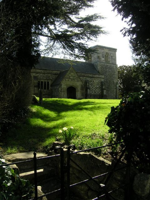
![Parish church [1] The Anglican parish church of St Mary the Virgin is located in High Street. Built on the site of an earlier Saxon church, there is a late 12th or early 13th century nave, with the tower and chancel added in the 16th century. The building was extensively restored in 1855. Constructed of limestone and flint chequers, the tower is of limestone ashlar, all under Welsh slate roofs. Listed, grade II*, with details at: <span class="nowrap"><a title="https://historicengland.org.uk/listing/the-list/list-entry/1023996" rel="nofollow ugc noopener" href="https://historicengland.org.uk/listing/the-list/list-entry/1023996">Link</a><img style="margin-left:2px;" alt="External link" title="External link - shift click to open in new window" src="https://s1.geograph.org.uk/img/external.png" width="10" height="10"/></span>
The village of Shrewton is located on Salisbury Plain and is made up of several early communities and was, until 1934 three separate parishes. The name Shrewton comes from the Old English word for sheriff’s farm or settlement. The village lies on the east to west road from London to Bridgwater via Amesbury and Warminster. The River Till which rises near Tilshead flows through the village on its way to join the River Wylye near Stapleford.](https://s2.geograph.org.uk/geophotos/07/38/04/7380466_e965add0.jpg)
![Parish church [2] The fine 19th century arch-braced collar roof of the nave.
The Anglican parish church of St Mary the Virgin is located in High Street. Built on the site of an earlier Saxon church, there is a late 12th or early 13th century nave, with the tower and chancel added in the 16th century. The building was extensively restored in 1855. Constructed of limestone and flint chequers, the tower is of limestone ashlar, all under Welsh slate roofs. Listed, grade II*, with details at: <span class="nowrap"><a title="https://historicengland.org.uk/listing/the-list/list-entry/1023996" rel="nofollow ugc noopener" href="https://historicengland.org.uk/listing/the-list/list-entry/1023996">Link</a><img style="margin-left:2px;" alt="External link" title="External link - shift click to open in new window" src="https://s1.geograph.org.uk/img/external.png" width="10" height="10"/></span>
The village of Shrewton is located on Salisbury Plain and is made up of several early communities and was, until 1934 three separate parishes. The name Shrewton comes from the Old English word for sheriff’s farm or settlement. The village lies on the east to west road from London to Bridgwater via Amesbury and Warminster. The River Till which rises near Tilshead flows through the village on its way to join the River Wylye near Stapleford.](https://s3.geograph.org.uk/geophotos/07/38/04/7380467_4b2ede71.jpg)
![Parish church [3] The nave and chancel arch.
The Anglican parish church of St Mary the Virgin is located in High Street. Built on the site of an earlier Saxon church, there is a late 12th or early 13th century nave, with the tower and chancel added in the 16th century. The building was extensively restored in 1855. Constructed of limestone and flint chequers, the tower is of limestone ashlar, all under Welsh slate roofs. Listed, grade II*, with details at: <span class="nowrap"><a title="https://historicengland.org.uk/listing/the-list/list-entry/1023996" rel="nofollow ugc noopener" href="https://historicengland.org.uk/listing/the-list/list-entry/1023996">Link</a><img style="margin-left:2px;" alt="External link" title="External link - shift click to open in new window" src="https://s1.geograph.org.uk/img/external.png" width="10" height="10"/></span>
The village of Shrewton is located on Salisbury Plain and is made up of several early communities and was, until 1934 three separate parishes. The name Shrewton comes from the Old English word for sheriff’s farm or settlement. The village lies on the east to west road from London to Bridgwater via Amesbury and Warminster. The River Till which rises near Tilshead flows through the village on its way to join the River Wylye near Stapleford.](https://s0.geograph.org.uk/geophotos/07/38/04/7380468_18fd571a.jpg)
![Parish church [4] The chancel and east window.
The Anglican parish church of St Mary the Virgin is located in High Street. Built on the site of an earlier Saxon church, there is a late 12th or early 13th century nave, with the tower and chancel added in the 16th century. The building was extensively restored in 1855. Constructed of limestone and flint chequers, the tower is of limestone ashlar, all under Welsh slate roofs. Listed, grade II*, with details at: <span class="nowrap"><a title="https://historicengland.org.uk/listing/the-list/list-entry/1023996" rel="nofollow ugc noopener" href="https://historicengland.org.uk/listing/the-list/list-entry/1023996">Link</a><img style="margin-left:2px;" alt="External link" title="External link - shift click to open in new window" src="https://s1.geograph.org.uk/img/external.png" width="10" height="10"/></span>
The village of Shrewton is located on Salisbury Plain and is made up of several early communities and was, until 1934 three separate parishes. The name Shrewton comes from the Old English word for sheriff’s farm or settlement. The village lies on the east to west road from London to Bridgwater via Amesbury and Warminster. The River Till which rises near Tilshead flows through the village on its way to join the River Wylye near Stapleford.](https://s1.geograph.org.uk/geophotos/07/38/04/7380469_0cd7be75.jpg)
![Parish church [5] The 19th century Romanesque style font.
The Anglican parish church of St Mary the Virgin is located in High Street. Built on the site of an earlier Saxon church, there is a late 12th or early 13th century nave, with the tower and chancel added in the 16th century. The building was extensively restored in 1855. Constructed of limestone and flint chequers, the tower is of limestone ashlar, all under Welsh slate roofs. Listed, grade II*, with details at: <span class="nowrap"><a title="https://historicengland.org.uk/listing/the-list/list-entry/1023996" rel="nofollow ugc noopener" href="https://historicengland.org.uk/listing/the-list/list-entry/1023996">Link</a><img style="margin-left:2px;" alt="External link" title="External link - shift click to open in new window" src="https://s1.geograph.org.uk/img/external.png" width="10" height="10"/></span>
The village of Shrewton is located on Salisbury Plain and is made up of several early communities and was, until 1934 three separate parishes. The name Shrewton comes from the Old English word for sheriff’s farm or settlement. The village lies on the east to west road from London to Bridgwater via Amesbury and Warminster. The River Till which rises near Tilshead flows through the village on its way to join the River Wylye near Stapleford.](https://s2.geograph.org.uk/geophotos/07/38/04/7380470_2f6a56f0.jpg)
![Parish church [6] Part of the churchyard.
The Anglican parish church of St Mary the Virgin is located in High Street. Built on the site of an earlier Saxon church, there is a late 12th or early 13th century nave, with the tower and chancel added in the 16th century. The building was extensively restored in 1855. Constructed of limestone and flint chequers, the tower is of limestone ashlar, all under Welsh slate roofs. Listed, grade II*, with details at: <span class="nowrap"><a title="https://historicengland.org.uk/listing/the-list/list-entry/1023996" rel="nofollow ugc noopener" href="https://historicengland.org.uk/listing/the-list/list-entry/1023996">Link</a><img style="margin-left:2px;" alt="External link" title="External link - shift click to open in new window" src="https://s1.geograph.org.uk/img/external.png" width="10" height="10"/></span>
The village of Shrewton is located on Salisbury Plain and is made up of several early communities and was, until 1934 three separate parishes. The name Shrewton comes from the Old English word for sheriff’s farm or settlement. The village lies on the east to west road from London to Bridgwater via Amesbury and Warminster. The River Till which rises near Tilshead flows through the village on its way to join the River Wylye near Stapleford.](https://s3.geograph.org.uk/geophotos/07/38/04/7380471_3a8c6e6d.jpg)
![Parish church [7] Part of the churchyard.
The Anglican parish church of St Mary the Virgin is located in High Street. Built on the site of an earlier Saxon church, there is a late 12th or early 13th century nave, with the tower and chancel added in the 16th century. The building was extensively restored in 1855. Constructed of limestone and flint chequers, the tower is of limestone ashlar, all under Welsh slate roofs. Listed, grade II*, with details at: <span class="nowrap"><a title="https://historicengland.org.uk/listing/the-list/list-entry/1023996" rel="nofollow ugc noopener" href="https://historicengland.org.uk/listing/the-list/list-entry/1023996">Link</a><img style="margin-left:2px;" alt="External link" title="External link - shift click to open in new window" src="https://s1.geograph.org.uk/img/external.png" width="10" height="10"/></span>
The village of Shrewton is located on Salisbury Plain and is made up of several early communities and was, until 1934 three separate parishes. The name Shrewton comes from the Old English word for sheriff’s farm or settlement. The village lies on the east to west road from London to Bridgwater via Amesbury and Warminster. The River Till which rises near Tilshead flows through the village on its way to join the River Wylye near Stapleford.](https://s0.geograph.org.uk/geophotos/07/38/04/7380472_1dc5813e.jpg)

![Parish church [8] The railings and gates in front of the church of St Mary the Virgin were erected in 1832. Made of cast iron, set on a low wall, with a length of some 45 yards, there is a pair of double gates and a single gate. Listed, grade II, with details at: <span class="nowrap"><a title="https://historicengland.org.uk/listing/the-list/list-entry/1355662" rel="nofollow ugc noopener" href="https://historicengland.org.uk/listing/the-list/list-entry/1355662">Link</a><img style="margin-left:2px;" alt="External link" title="External link - shift click to open in new window" src="https://s1.geograph.org.uk/img/external.png" width="10" height="10"/></span>
The Anglican parish church of St Mary the Virgin is located in High Street. Built on the site of an earlier Saxon church, there is a late 12th or early 13th century nave, with the tower and chancel added in the 16th century. The building was extensively restored in 1855. Constructed of limestone and flint chequers, the tower is of limestone ashlar, all under Welsh slate roofs. Listed, grade II*, with details at: <span class="nowrap"><a title="https://historicengland.org.uk/listing/the-list/list-entry/1023996" rel="nofollow ugc noopener" href="https://historicengland.org.uk/listing/the-list/list-entry/1023996">Link</a><img style="margin-left:2px;" alt="External link" title="External link - shift click to open in new window" src="https://s1.geograph.org.uk/img/external.png" width="10" height="10"/></span>
The village of Shrewton is located on Salisbury Plain and is made up of several early communities and was, until 1934 three separate parishes. The name Shrewton comes from the Old English word for sheriff’s farm or settlement. The village lies on the east to west road from London to Bridgwater via Amesbury and Warminster. The River Till which rises near Tilshead flows through the village on its way to join the River Wylye near Stapleford.](https://s3.geograph.org.uk/geophotos/07/38/04/7380475_6a58bc71.jpg)
![Shrewton houses [29] In High Street and mostly hidden behind the garden wall and entrance gates are Church Cottage and, to the left, Church House. Church House was built in the mid 17th century with a bay added in the early 19th century. Constructed of cob and flint, the first floor timber framed, the 19th century addition in brick, all under a hipped tile roof. The interior retains some important 17th century features. Listed, grade II, with details at: <span class="nowrap"><a title="https://historicengland.org.uk/listing/the-list/list-entry/1182053" rel="nofollow ugc noopener" href="https://historicengland.org.uk/listing/the-list/list-entry/1182053">Link</a><img style="margin-left:2px;" alt="External link" title="External link - shift click to open in new window" src="https://s1.geograph.org.uk/img/external.png" width="10" height="10"/></span>
The village of Shrewton is located on Salisbury Plain and is made up of several early communities and was, until 1934 three separate parishes. The name Shrewton comes from the Old English word for sheriff’s farm or settlement. The village lies on the east to west road from London to Bridgwater via Amesbury and Warminster. The River Till which rises near Tilshead flows through the village on its way to join the River Wylye near Stapleford.](https://s2.geograph.org.uk/geophotos/07/38/05/7380550_f234ab59.jpg)
Shrewton is located at Grid Ref: SU0543 (Lat: 51.188536, Lng: -1.920553)
Unitary Authority: Wiltshire
Police Authority: Wiltshire
What 3 Words
///coasted.conducted.curry. Near Shrewton, Wiltshire
Nearby Locations
Related Wikis
St Mary's Church, Maddington
St Mary's Church in the Maddington area of Shrewton, Wiltshire, in the west of England, was built in the late 12th century. It is recorded in the National...

Shrewton
Shrewton is a village and civil parish on Salisbury Plain in Wiltshire, England, around 6 miles (9.7 km) west of Amesbury and 14 miles (23 km) north of...

Rollestone
Rollestone is a small village and former civil parish on Salisbury Plain in Wiltshire, England. It is near the River Till. Its nearest town is Amesbury...
St George's Church, Orcheston
St George's Church in Orcheston, Wiltshire, England, was built in the 13th century. It is recorded in the National Heritage List for England as a Grade...
Have you been to Shrewton?
Leave your review of Shrewton below (or comments, questions and feedback).