Shaw cum Donnington

Civil Parish in Berkshire

England

Shaw cum Donnington

A34 northbound towards the M4
A34 northbound towards the M4 Credit: Ian S

Shaw cum Donnington is a civil parish located in the county of Berkshire, England. Situated just south of the River Thames, it covers an area of approximately 7.5 square miles. The parish consists of the two villages of Shaw and Donnington, which are separated by a small stream.

Shaw is the larger of the two villages and has a population of around 3,000 residents. It is a predominantly residential area, with a mix of housing styles ranging from modern developments to traditional cottages. The village is well-served by amenities, including a primary school, a post office, a convenience store, and several pubs.

Donnington, on the other hand, is a smaller village with a population of around 1,000 residents. It has a more rural character, with a number of farms and open fields in the surrounding area. The village is known for its historic church, which dates back to the 12th century and attracts visitors interested in its architectural features.

Both Shaw and Donnington benefit from their proximity to Newbury, a larger town located just a few miles to the west. Residents have easy access to an array of shops, restaurants, and leisure facilities in Newbury, as well as excellent transport links, including a train station and major road networks.

Overall, Shaw cum Donnington offers a pleasant and peaceful living environment with a strong sense of community. Its convenient location and range of amenities make it an attractive place to reside for both families and individuals seeking a rural setting within easy reach of larger urban areas.

If you have any feedback on the listing, please let us know in the comments section below.

Shaw cum Donnington Images

Images are sourced within 2km of 51.424485/-1.319074 or Grid Reference SU4769. Thanks to Geograph Open Source API. All images are credited.

A34 northbound towards the M4
The A34 northbound at the M4 junction
The A34 looking northbound
A New Gate On Arlington Grange Farm.
A New Gate
On Arlington Grange Farm.
Home Farm
Home Farm
The Fox and Hounds, Donnington If ever a pub was a survivor, it's this one.
Originally an isolated roadside pub beside the old A34, which is the road in front, now unclassified, it was firstly by passed by a new A34 alignment running behind the pub, and then by yet another  rebuild of the A34, the Newbury by pass, on an embankment in front again.
The pub is sandwiched onto this narrow island of land between the three roads, and is still serving a decent pint.
The Fox and Hounds, Donnington
If ever a pub was a survivor, it's this one. Originally an isolated roadside pub beside the old A34, which is the road in front, now unclassified, it was firstly by passed by a new A34 alignment running behind the pub, and then by yet another rebuild of the A34, the Newbury by pass, on an embankment in front again. The pub is sandwiched onto this narrow island of land between the three roads, and is still serving a decent pint.
Fire & Flood Snelsmore Common is a variable environment. In dry weather, fire on the gorse and heather heath is a constant threat, hence the need for this watchtower.
But in wet weather, many areas become very waterlogged.
Fire & Flood
Snelsmore Common is a variable environment. In dry weather, fire on the gorse and heather heath is a constant threat, hence the need for this watchtower. But in wet weather, many areas become very waterlogged.
Fire Beaters, Snelsmore Common
Curridge Road bridge over A34 The A34 is a major road which runs from the A33 and M3 at Winchester in Hampshire, to the A6 & A6042 in Salford, Greater Manchester. It forms a large part of the major trunk route from Southampton, via Oxford, to Birmingham, The Potteries and Manchester.

The road is in two sections. The northern section runs south through Manchester and Cheadle, and bypasses Handforth, Wilmslow and Alderley Edge, before passing through Congleton, Newcastle-under-Lyme, and the southern suburbs of Stoke-on-Trent. It then continues south via Stone, Stafford, Cannock and Walsall, passes through the middle of Birmingham (where it briefly merges with the A41), before meeting the M42 motorway at junction 4 south of Solihull.

The southern section begins some 50 miles (80 km) to the south, at junction 9 of the M40 motorway, 10 miles (16 km) north of Oxford. It continues south as the western part of the Oxford Ring Road, crossing the River Thames on the A34 Road Bridge. It then bypasses Abingdon, Didcot, and Newbury before finally finishing just east of Winchester, at junction 9 of the M3 motorway. This part of the A34 is dual carriageway throughout.

Together with parts of the M3 and the M40, the southern section of the A34 forms an important route carrying freight from Southampton to the Midlands. Because of the volume of traffic, bypasses were built along this route; at Newbury on the A34, and at Twyford Down near Winchester on the M3, but these were controversial for environmental reasons and were the scene of significant direct action environmental protests in the 1990s. Instead of cutting a short road tunnel through Twyford Down, the entire escarpment was carved-out and the motorway placed through it.

(abridged from Wikipedia <span class="nowrap"><a title="http://en.wikipedia.org/wiki/A34_road" rel="nofollow ugc noopener" href="http://en.wikipedia.org/wiki/A34_road">Link</a><img style="margin-left:2px;" alt="External link" title="External link - shift click to open in new window" src="https://s1.geograph.org.uk/img/external.png" width="10" height="10"/></span> )
Curridge Road bridge over A34
The A34 is a major road which runs from the A33 and M3 at Winchester in Hampshire, to the A6 & A6042 in Salford, Greater Manchester. It forms a large part of the major trunk route from Southampton, via Oxford, to Birmingham, The Potteries and Manchester. The road is in two sections. The northern section runs south through Manchester and Cheadle, and bypasses Handforth, Wilmslow and Alderley Edge, before passing through Congleton, Newcastle-under-Lyme, and the southern suburbs of Stoke-on-Trent. It then continues south via Stone, Stafford, Cannock and Walsall, passes through the middle of Birmingham (where it briefly merges with the A41), before meeting the M42 motorway at junction 4 south of Solihull. The southern section begins some 50 miles (80 km) to the south, at junction 9 of the M40 motorway, 10 miles (16 km) north of Oxford. It continues south as the western part of the Oxford Ring Road, crossing the River Thames on the A34 Road Bridge. It then bypasses Abingdon, Didcot, and Newbury before finally finishing just east of Winchester, at junction 9 of the M3 motorway. This part of the A34 is dual carriageway throughout. Together with parts of the M3 and the M40, the southern section of the A34 forms an important route carrying freight from Southampton to the Midlands. Because of the volume of traffic, bypasses were built along this route; at Newbury on the A34, and at Twyford Down near Winchester on the M3, but these were controversial for environmental reasons and were the scene of significant direct action environmental protests in the 1990s. Instead of cutting a short road tunnel through Twyford Down, the entire escarpment was carved-out and the motorway placed through it. (abridged from Wikipedia LinkExternal link )
Flyover for A339 northbound over A34 The A34 is a major road which runs from the A33 and M3 at Winchester in Hampshire, to the A6 & A6042 in Salford, Greater Manchester. It forms a large part of the major trunk route from Southampton, via Oxford, to Birmingham, The Potteries and Manchester.

The road is in two sections. The northern section runs south through Manchester and Cheadle, and bypasses Handforth, Wilmslow and Alderley Edge, before passing through Congleton, Newcastle-under-Lyme, and the southern suburbs of Stoke-on-Trent. It then continues south via Stone, Stafford, Cannock and Walsall, passes through the middle of Birmingham (where it briefly merges with the A41), before meeting the M42 motorway at junction 4 south of Solihull.

The southern section begins some 50 miles (80 km) to the south, at junction 9 of the M40 motorway, 10 miles (16 km) north of Oxford. It continues south as the western part of the Oxford Ring Road, crossing the River Thames on the A34 Road Bridge. It then bypasses Abingdon, Didcot, and Newbury before finally finishing just east of Winchester, at junction 9 of the M3 motorway. This part of the A34 is dual carriageway throughout.

Together with parts of the M3 and the M40, the southern section of the A34 forms an important route carrying freight from Southampton to the Midlands. Because of the volume of traffic, bypasses were built along this route; at Newbury on the A34, and at Twyford Down near Winchester on the M3, but these were controversial for environmental reasons and were the scene of significant direct action environmental protests in the 1990s. Instead of cutting a short road tunnel through Twyford Down, the entire escarpment was carved-out and the motorway placed through it.

(abridged from Wikipedia <span class="nowrap"><a title="http://en.wikipedia.org/wiki/A34_road" rel="nofollow ugc noopener" href="http://en.wikipedia.org/wiki/A34_road">Link</a><img style="margin-left:2px;" alt="External link" title="External link - shift click to open in new window" src="https://s1.geograph.org.uk/img/external.png" width="10" height="10"/></span> )
Flyover for A339 northbound over A34
The A34 is a major road which runs from the A33 and M3 at Winchester in Hampshire, to the A6 & A6042 in Salford, Greater Manchester. It forms a large part of the major trunk route from Southampton, via Oxford, to Birmingham, The Potteries and Manchester. The road is in two sections. The northern section runs south through Manchester and Cheadle, and bypasses Handforth, Wilmslow and Alderley Edge, before passing through Congleton, Newcastle-under-Lyme, and the southern suburbs of Stoke-on-Trent. It then continues south via Stone, Stafford, Cannock and Walsall, passes through the middle of Birmingham (where it briefly merges with the A41), before meeting the M42 motorway at junction 4 south of Solihull. The southern section begins some 50 miles (80 km) to the south, at junction 9 of the M40 motorway, 10 miles (16 km) north of Oxford. It continues south as the western part of the Oxford Ring Road, crossing the River Thames on the A34 Road Bridge. It then bypasses Abingdon, Didcot, and Newbury before finally finishing just east of Winchester, at junction 9 of the M3 motorway. This part of the A34 is dual carriageway throughout. Together with parts of the M3 and the M40, the southern section of the A34 forms an important route carrying freight from Southampton to the Midlands. Because of the volume of traffic, bypasses were built along this route; at Newbury on the A34, and at Twyford Down near Winchester on the M3, but these were controversial for environmental reasons and were the scene of significant direct action environmental protests in the 1990s. Instead of cutting a short road tunnel through Twyford Down, the entire escarpment was carved-out and the motorway placed through it. (abridged from Wikipedia LinkExternal link )
B4494 bridge over A34 The A34 is a major road which runs from the A33 and M3 at Winchester in Hampshire, to the A6 & A6042 in Salford, Greater Manchester. It forms a large part of the major trunk route from Southampton, via Oxford, to Birmingham, The Potteries and Manchester.

The road is in two sections. The northern section runs south through Manchester and Cheadle, and bypasses Handforth, Wilmslow and Alderley Edge, before passing through Congleton, Newcastle-under-Lyme, and the southern suburbs of Stoke-on-Trent. It then continues south via Stone, Stafford, Cannock and Walsall, passes through the middle of Birmingham (where it briefly merges with the A41), before meeting the M42 motorway at junction 4 south of Solihull.

The southern section begins some 50 miles (80 km) to the south, at junction 9 of the M40 motorway, 10 miles (16 km) north of Oxford. It continues south as the western part of the Oxford Ring Road, crossing the River Thames on the A34 Road Bridge. It then bypasses Abingdon, Didcot, and Newbury before finally finishing just east of Winchester, at junction 9 of the M3 motorway. This part of the A34 is dual carriageway throughout.

Together with parts of the M3 and the M40, the southern section of the A34 forms an important route carrying freight from Southampton to the Midlands. Because of the volume of traffic, bypasses were built along this route; at Newbury on the A34, and at Twyford Down near Winchester on the M3, but these were controversial for environmental reasons and were the scene of significant direct action environmental protests in the 1990s. Instead of cutting a short road tunnel through Twyford Down, the entire escarpment was carved-out and the motorway placed through it.

(abridged from Wikipedia <span class="nowrap"><a title="http://en.wikipedia.org/wiki/A34_road" rel="nofollow ugc noopener" href="http://en.wikipedia.org/wiki/A34_road">Link</a><img style="margin-left:2px;" alt="External link" title="External link - shift click to open in new window" src="https://s1.geograph.org.uk/img/external.png" width="10" height="10"/></span> )
B4494 bridge over A34
The A34 is a major road which runs from the A33 and M3 at Winchester in Hampshire, to the A6 & A6042 in Salford, Greater Manchester. It forms a large part of the major trunk route from Southampton, via Oxford, to Birmingham, The Potteries and Manchester. The road is in two sections. The northern section runs south through Manchester and Cheadle, and bypasses Handforth, Wilmslow and Alderley Edge, before passing through Congleton, Newcastle-under-Lyme, and the southern suburbs of Stoke-on-Trent. It then continues south via Stone, Stafford, Cannock and Walsall, passes through the middle of Birmingham (where it briefly merges with the A41), before meeting the M42 motorway at junction 4 south of Solihull. The southern section begins some 50 miles (80 km) to the south, at junction 9 of the M40 motorway, 10 miles (16 km) north of Oxford. It continues south as the western part of the Oxford Ring Road, crossing the River Thames on the A34 Road Bridge. It then bypasses Abingdon, Didcot, and Newbury before finally finishing just east of Winchester, at junction 9 of the M3 motorway. This part of the A34 is dual carriageway throughout. Together with parts of the M3 and the M40, the southern section of the A34 forms an important route carrying freight from Southampton to the Midlands. Because of the volume of traffic, bypasses were built along this route; at Newbury on the A34, and at Twyford Down near Winchester on the M3, but these were controversial for environmental reasons and were the scene of significant direct action environmental protests in the 1990s. Instead of cutting a short road tunnel through Twyford Down, the entire escarpment was carved-out and the motorway placed through it. (abridged from Wikipedia LinkExternal link )
Lay-by by A34 The A34 is on an embankment here, which means that the embankment has been made wider to give space for this lay-by
Lay-by by A34
The A34 is on an embankment here, which means that the embankment has been made wider to give space for this lay-by
Old Milestone by the former A34, north of Donnington Carved stone post by the UC road (was A34), in parish of Shaw cum Donnington (West Berkshire District), opposite the Fox & Hounds PH just South of by-pass bridge, on wide grass verge behind footpath and cycle track, on West side of road. Ilsley gable, erected by the Andover & Chilton Pond turnpike trust in the 18th century. 

Inscription reads:-
To
Newbury 2
Miles
Ilsley 7
Abingdon 18
Oxford 24
1776 
Carved benchmark at bottom of face. 

Milestone Society National ID: BE_ABNE18
Old Milestone by the former A34, north of Donnington
Carved stone post by the UC road (was A34), in parish of Shaw cum Donnington (West Berkshire District), opposite the Fox & Hounds PH just South of by-pass bridge, on wide grass verge behind footpath and cycle track, on West side of road. Ilsley gable, erected by the Andover & Chilton Pond turnpike trust in the 18th century. Inscription reads:- To Newbury 2 Miles Ilsley 7 Abingdon 18 Oxford 24 1776 Carved benchmark at bottom of face. Milestone Society National ID: BE_ABNE18
Snelsmore Common Fire Tower
Snelsmore Common
Fire Tower
A34 northbound
A34 northbound
A34 northbound Approaching the flying junction with the A339.
A34 northbound
Approaching the flying junction with the A339.
Fields at Grange Farm
Path near Grange Farm
Show me another place!

Shaw cum Donnington is located at Grid Ref: SU4769 (Lat: 51.424485, Lng: -1.319074)

Unitary Authority: West Berkshire

Police Authority: Thames Valley

What 3 Words

///lousy.vesting.soil. Near Newbury, Berkshire

Related Wikis

Shaw-cum-Donnington

Shaw-cum-Donnington is a civil parish in West Berkshire, England with all of its urban or suburban area immediately north of the largest town in the district...

Donnington, Berkshire

Donnington is an English suburban village in the civil parish of Shaw-cum-Donnington, just north of the town of Newbury, Berkshire. It contains a ruined...

Trinity School, Newbury

Trinity School is a co-educational secondary school with academy status in Newbury, Berkshire, England. The school opened in September 1999 when two existing...

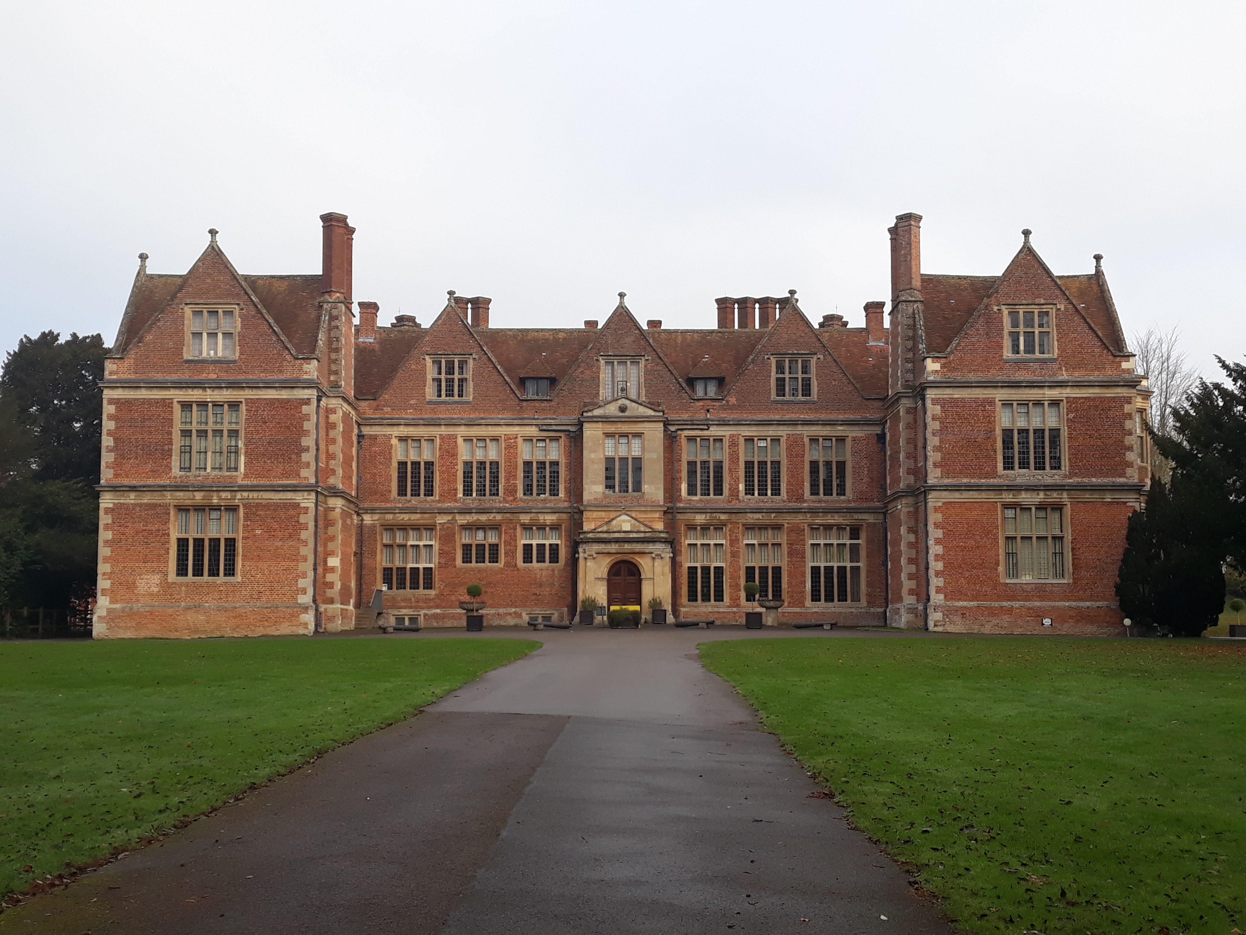
Shaw House, Berkshire

Shaw House is an important example of an early symmetrical H-plan Elizabethan mansion, located at Shaw, on the north-eastern outskirts of Newbury in Berkshire...

Donnington Friary

Donnington Friary was a friary of crouched friars at Donnington in the English county of Berkshire. At the time of suppression the establishment was recorded...
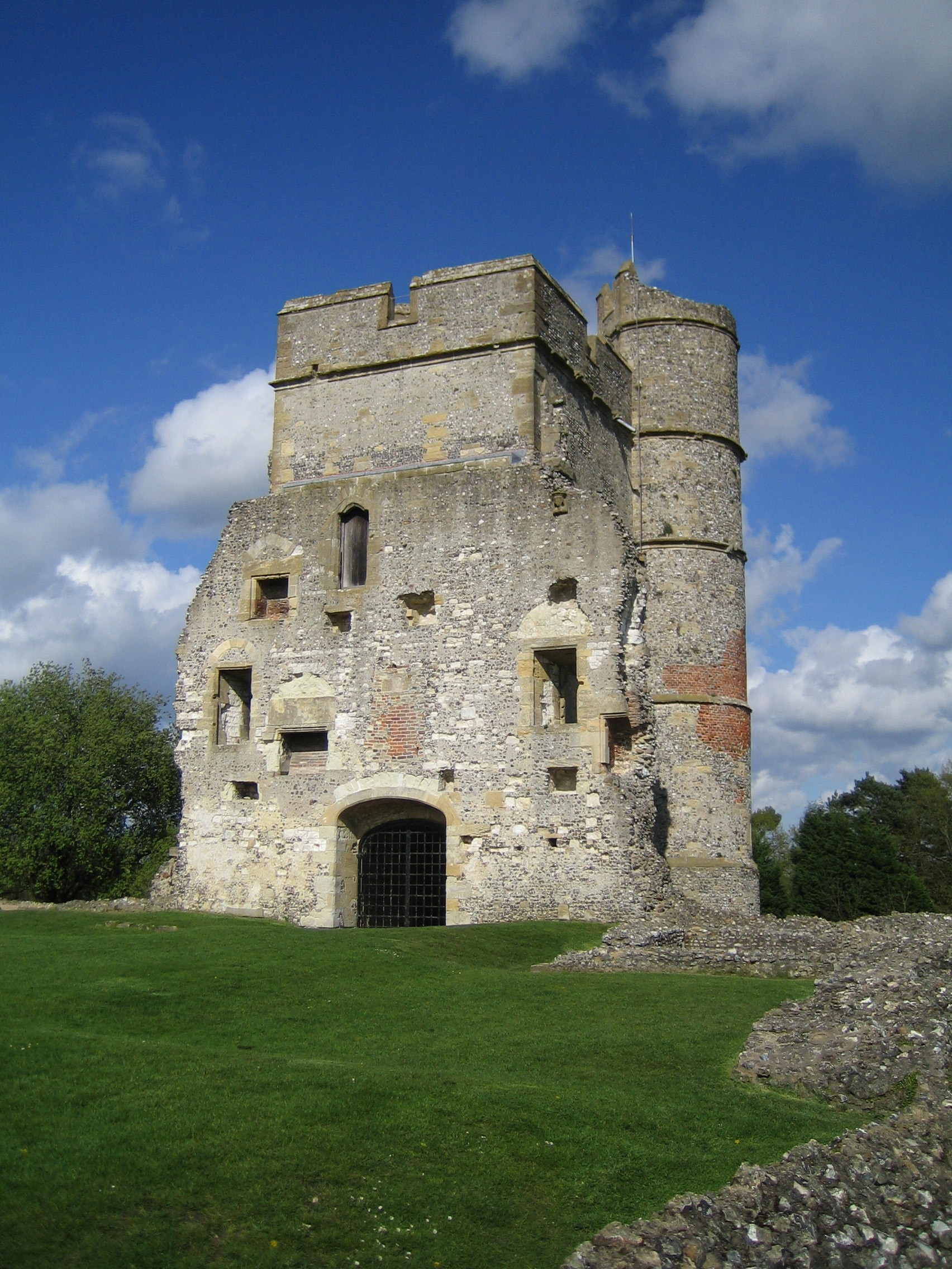
Donnington Castle

Donnington Castle is a ruined medieval castle, situated in the small village of Donnington, just north of the town of Newbury in the English county of...

Second Battle of Newbury

The Second Battle of Newbury was a battle of the First English Civil War fought on 27 October 1644, in Speen, adjoining Newbury in Berkshire. The battle...

Mary Hare School

Mary Hare School is a residential co-educational Non-Maintained special school for deaf pupils in Newbury, Berkshire, England. It consists of around 230...

Nearby Amenities

Located within 500m of 51.424485,-1.319074
Power: tower
Lat/Long: 51.421582/-1.3145694
Power: tower
Lat/Long: 51.4218663/-1.3165167
Power: tower
Lat/Long: 51.4221172/-1.3183889
Power: tower
Lat/Long: 51.4218981/-1.3197219
Power: tower
Lat/Long: 51.4216898/-1.3209799
Power: tower
Lat/Long: 51.4214632/-1.322321
Material: wood
Power: tower
Lat/Long: 51.4217961/-1.3237412
The data included in this document is from www.openstreetmap.org. The data is made available under ODbL.

Have you been to Shaw cum Donnington?

Leave your review of Shaw cum Donnington below (or comments, questions and feedback).